


Mount Rainier, Maryland
Mount Rainier is a city of 8,245 people in Prince George's County, Maryland, founded in 1910.
Why visit Mount Rainier
Townapedia lists 84 museums and landmarks, 50 parks and trails, 48 places to eat, 1 place to stay and 14 attractions in and around town.
Highlights include Amtrak Railroad Anacostia Bridge, Carroll Avenue Bridge, Adams Memorial and Alexander Crummell School.
July is the warmest month, with average highs of 90°F; January lows average 28°F.
Weather in Mount Rainier
Forecast from the National Weather Service. Full forecast
About Mount Rainier
Mount Rainier () is a city in Prince George's County, Maryland, United States, bordering Washington, D.C. The population was 8,333 at the 2020 census. Mount Rainier is contained between the Northwest Branch Anacostia River, Cedar Lane Alley, and 34th Street to the north, 37th Street and 37th Place to the northeast, Upshur Street and Queens Chapel Road to the west, the CSX Capital Subdivision train tracks to the east, and Eastern Avenue NE to the south. Mount Rainier got its start as a streetcar suburb, when tracks were laid for the 82 Streetcar Line.
From the Wikipedia article Mount Rainier, Maryland (this version), under CC BY-SA 4.0.
Things to do14

Amtrak Railroad Anacostia Bridge
Bridge · 2.1 mi
Bridge in United States of America
Carroll Avenue Bridge
Bridge · 3.4 mi
Bridge in Takoma Park, Maryland, United States
New York Avenue Bridge
Bridge · 3.0 mi
Bridge crossing over Amtrak, CSX, and WMATA railway lines in Washington, D.C.
New York Avenue Bridge
Bridge · 2.1 mi
Bridge crossing over the Anacostia River in Washington, D.C.

School of Nursing at The Catholic University of America
School · 1.9 mi
Nursing school of Washington, D.C., U.S
University of Maryland
School · 3.4 mi
Public research university in the city of College Park in Prince George's County, Maryland, USA
University of Maryland Global Campus
School · 3.0 mi
One of 11 degree-granting institutions within the University System of Maryland

2 more on the map.
Museums and landmarks84

Adams Memorial
Monument and historic site · National Register of Historic Places · 2.5 mi
Artwork by Augustus Saint-Gaudens

Alexander Crummell School
Monument and historic site · National Register of Historic Places · 2.3 mi
Historic school building in Washington, DC

Andrew Rankin Memorial Chapel, Frederick Douglas Memorial Hall, Founders Library
Monument and historic site · National Register of Historic Places · 3.3 mi
Library
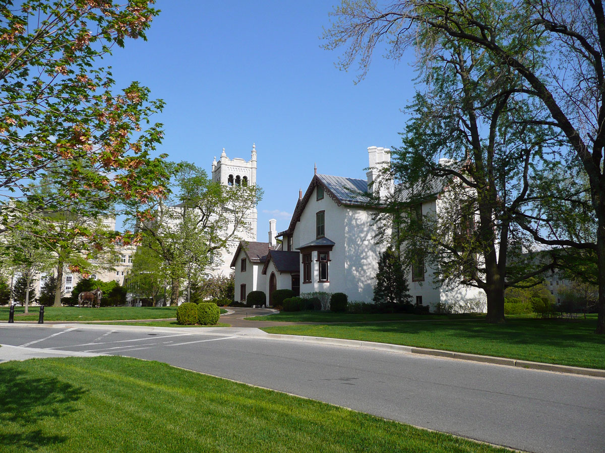
Armed Forces Retirement Home-Washington
Monument and historic site · National Register of Historic Places · 2.4 mi
United States historic place
Atlas Performing Arts Center
Monument and historic site · National Register of Historic Places · 3.2 mi
Arts centre in Washington, D.C.
Blanche Kelso Bruce Elementary School
Monument and historic site · National Register of Historic Places · 3.4 mi
All-black school and community center during the Jim Crow era in the United States
Bloomingdale
Monument and historic site · National Register of Historic Places · 3.1 mi
Neighborhood and historic district in Washington, D.C.

Brooks Mansion
Monument and historic site · National Register of Historic Places · 1.7 mi
Greek Revival plantation house
Children's Country Home
Monument and historic site · National Register of Historic Places · 0.7 mi
Hospital
College Heights Estates Historic District
Monument and historic site · National Register of Historic Places · 2.5 mi
Historic district in Maryland, United States

Engine Company 12
Monument and historic site · National Register of Historic Places · 3.2 mi
Fire station in Washington, D.C.


Engine Company 27
Monument and historic site · National Register of Historic Places · 3.1 mi
Fire station in Washington, D.C.
72 more on the map.
Parks, trails and playgrounds50

Schuetzen Park
Park · 3.2 mi
German-American community recreation area (1866–1891)
Swampoodle Park
Park · 3.4 mi
Urban Park in the NoMa neighborhood of Washington, DC
David C. Driskell Community Park
Park · 1.0 mi
32 acres of park land Two picnic pavilions, available by permit only Basketball court Tennis courts Playgrounds Walking and biking...
3911 Hamilton Street, Hyattsville
38 more on the map.
Restaurants and cafes48

Pizzeria Paradiso
Restaurant · Pizza · 1.2 mi
Casual restaurant with a central oven for wood-fired pizzas has a vast menu of international beers.
4800 Rhode Island Avenue, Hyattsville
We-Th 16:00-21:00; Fr-Su 13:00-21:00
Krystal Tex-Mex
Restaurant · Mexican, Tex-Mex · 1.5 mi
3629 12th Street Northeast, Washington
Mo-Su 11:00-21:00
Mid Atlantic Seafood
Restaurant · Fish · 0.6 mi
3100 Queens Chapel Road, Hyattsville
Mo-Th,Sa 10:00-21:00; Fr 10:00-21:30; Su 11:00-21:00
Pennyroyal Station
Restaurant · Comfort Food · 0.4 mi
3310 Rhode Island Avenue, Mount Rainier
We-Fr 11:00-14:30, Tu-Th 16:00-21:00, Fr,Sa 17:00-22:00, Su...

DC Brau
Brewery and winery · 0.9 mi
3178 Bladensburg Road Northeast
Th 16:00-21:00, Fr 15:00-23:00, Sa 12:00-20:00, Su 12:00-18:00
Dodah's Kitchen
Restaurant · 0.4 mi
4300 Rhode Island Avenue, Mount Rainier
Mo-Sa 11:00-20:00; Su 11:00-18:00

Maryland Meadworks
Bar and pub · 1.1 mi
4700 Rhode Island Avenue, Hyattsville
Th 16:00-19:00; Fr 16:00-22:00; Sa 14:00-22:00; Su 11:00-19:00
The Public Option
Brewery and winery · 1.5 mi
1601 Rhode Island Avenue Northeast, Washington
Fr 16:00-23:00; Sa 14:00-23:00; Su 14:00-21:00
La Cocina Tex-Mex
Restaurant · Tacos, Mexican, Tex-Mex · 1.5 mi
3740 12th Street NE;12th Street Northeast, Washington

36 more on the map.
History
In 1891, the City of Mount Rainier was named by a group of developers after the famous mountain in the state of Washington.
In 1899, the streetcar lines were extended from Washington D.C. through Hyattsville, Maryland. The Mount Rainier stop was located at the intersection of what is now known as Rhode Island Avenue and 34th Street. It was called the District Line Station. With the stop at Mount Rainier, it was easier to attract developers and prospective buyers because now the city offered easy access to get into and out of Washington.
Houses started to be built near the District Line Station after 1902. The homes in Mount Rainier were considered affordable, ranging from $2,000 to $5,000.
The business district aggregated around the streetcar station. In addition to the station, there were shops, grocery stores, a barbershop, laundry, and dry good stores. The first post office was established in 1904.
In 1910, the residents in the area around the streetcar station petitioned the Maryland State Legislature to incorporate Mount Rainier, and the city was incorporated by a charter granted on April 14, 1910.
In January 1912, the Mount Rainier volunteer fire department was created. The fire department was first located in a frame building and later moved to a brick structure located on 34th at Shepherd Street
From the History section of Mount Rainier, Maryland on Wikipedia, under CC BY-SA 4.0.
Where to stay1
Churches and places of worship60
Franciscan Monastery and Memorial
Church · Catholic · 1.1 mi
1400 Quincy Street Northeast
Israel Metropolitan Christian Methodist Episcopal Church
Church · 3.0 mi
Union Wesley African Methodist Episcopal Zion Church
Church · African Methodist Episcopal Zion · 0.8 mi
1860 Michigan Avenue Northeast, Washington
Shopping15
Gas and EV charging14
Schools, colleges and libraries77
Healthcare6
Rehabilitation & Specialized Care - Bunker Hill Road
Hospital · 0.9 mi
1731 Bunker Hill Road Northeast, Washington
Kaiser Permanente West Hyattsville Medical Center
Clinic and pharmacy · 1.1 mi
5320 Ager Road, Hyattsville
Map of Mount Rainier
250 places. The map loads OpenStreetMap tiles when you open it.
Climate by month
Monthly table
| Month | High | Low | Rain | Snow |
|---|---|---|---|---|
| Jan | 45°F | 28°F | 3.0 in | 4.7 in |
| Feb | 48°F | 30°F | 2.8 in | 2.3 in |
| Mar | 56°F | 36°F | 4.0 in | 1.4 in |
| Apr | 68°F | 46°F | 3.4 in | 0.0 in |
| May | 77°F | 57°F | 4.3 in | 0.0 in |
| Jun | 85°F | 66°F | 4.6 in | 0.0 in |
| Jul | 90°F | 71°F | 4.6 in | 0.0 in |
| Aug | 88°F | 69°F | 3.7 in | 0.0 in |
| Sep | 82°F | 62°F | 4.1 in | 0.0 in |
| Oct | 70°F | 49°F | 4.2 in | 0.0 in |
| Nov | 58°F | 39°F | 3.2 in | 0.0 in |
| Dec | 49°F | 32°F | 3.7 in | 1.3 in |
U.S. Climate Normals 1991-2020 for Natl Arboretum Dc (2 mi away), NOAA NCEI.
People and cost of living
American Community Survey 5-year estimates, 2020-2024, U.S. Census Bureau. Estimates have margins of error, larger for small towns.
Disaster history
Prince George's County has had 13 federal disaster declarations since 2000, most often for hurricanes.
- 2026-01-24: Severe Winter Storm (Winter Storm)
- 2020-03-26: Covid-19 Pandemic (Biological)
- 2020-03-13: Covid-19 (Biological)
- 2016-03-04: Severe Winter Storm And Snowstorm (Snowstorm)
- 2012-11-20: Hurricane Sandy (Hurricane)
- 2012-10-28: Hurricane Sandy (Hurricane)
OpenFEMA disaster declarations summaries.
Getting there and nearby towns
College Park Airport (CGS) is the nearest airport with scheduled flights listed in OpenStreetMap, 4 miles away.
- Brentwood 0 mi east, about 1 min by car
- Cottage City 1 mi east, about 1 min by car
- Hyattsville 1 mi north, about 2 min by car
- Chillum 2 mi northwest, about 3 min by car
- Colmar Manor 2 mi southeast, about 2 min by car
- Bladensburg 2 mi east, about 3 min by car
- Edmonston 2 mi east, about 3 min by car
- East Riverdale 3 mi northeast, about 5 min by car
- Cheverly 3 mi east, about 5 min by car
- Washington 4 mi southwest, about 6 min by car
Drive times are estimates from straight-line distance, not routes.
Local news
Headlines from INDB, the NEMICO news database.
Reviews, tips and questions
Loading what members have shared...
Sources and licences
- NCES EDGE (Public domain): public schools
- NOAA NCEI U.S. Climate Normals 1991-2020 (Public domain): climate by month
- OpenFEMA (Public domain): disaster declarations
- OpenStreetMap contributors (ODbL 1.0): places, airports, map data
- U.S. Census Bureau (Public domain): population, income, housing, education, commute
- Wikidata (CC0 1.0): elevation, founding date, time zone, website, landmarks and historic places
- Wikimedia Commons (see each image): photos
- Wikipedia (CC BY-SA 4.0): overview and history text
Photo credits
- Saint James Church (Mt Rainier, Maryland), Farragutful, CC BY-SA 3.0
- Engine House No 10 DC, Smallbones, CC0
- Kingman Park - 1991 - outlined in red, DefenseImagery.com, United States Department of Defense. MSGT Ken Hammond, photographer, Public domain
- Gallaudet tower, Andrew Kuchling from Vienna, Virginia, USA, CC BY-SA 2.0
- Deanwood Old Church, Smallbones, CC0
- Engine Co 12 DC, Farragutful, CC BY-SA 3.0
- H Street Playhouse, AgnosticPreachersKid, CC BY-SA 3.0
- Kenilworthgarden1, Jennifer Boyer from Maryland, USA, CC BY 2.0
- Gage School DC, Farragutful, CC BY-SA 3.0
- Entrance - Glenwood Cemetery - 2014-09-14, Tim1965, CC BY-SA 4.0
- National Home for Destitute Colored Women and Children, Farragutful, CC BY-SA 4.0
- St. Paul's Church, Cliff, CC BY 2.0
- Samuel-gompers-house, Dmadeo, CC BY-SA 3.0
- Petworth Branch Library, Farragutful, CC BY-SA 4.0
- LeDroit Park - intersection of 4th & T Streets, NW, AgnosticPreachersKid at English Wikipedia, CC BY-SA 3.0
- Mount St Sepulchre DC, Abraham Sobkowski OFM, CC BY-SA 2.5
- Langston Golf Course, NPS Photo, Public domain
- Theodore Roosevelt High School, 13th St. in upper NW, Washington, D.C., Carol M. Highsmith, Public domain
- Mayfair Mansons DC, Farragutful, CC BY-SA 3.0
- Ralph Bunche House DC, Smallbones, CC0
- Engine Company 27 DC, Smallbones, CC0
- Brooks Mansion DC, Smallbones, CC0
- Margaret Murray Washington School 2013, Farragutful, CC BY-SA 3.0
- DC Fire Alarm HQ, Smallbones, CC0
- Hecht warehouse washington dc, Superbass, CC BY-SA 3.0
- St. Gabriel Church DC 01, Farragutful, CC BY-SA 3.0
- Mary Church Terrell House, Shujenchang, CC BY-SA 3.0
- Alexander Crummell School, AgnosticPreachersKid, CC BY-SA 3.0
- Hampshire Garden Apartments DC, Farragutful, CC BY-SA 3.0
- Woodward and Lothrop Service Warehouse, AgnosticPreachersKid, CC BY-SA 3.0
- Uline Arena (Washington Coliseum), Rudi Riet from Washington, DC, United States, CC BY-SA 2.0
- General Oliver Otis Howard House - Howard University, AgnosticPreachersKid, CC BY-SA 3.0
- Newton Theater, AgnosticPreachersKid, CC BY-SA 3.0
- Andrew Rankin Chapel, Douglass Hall, and Founders Library at Howard University, Qwerty0 ( talk ), CC BY-SA 3.0
- Langston Terrace DC 1, Smallbones, CC0
- Glenwood Cemetery Mortuary Chapel DC, Farragutful, CC BY-SA 3.0
- Lincoln Cottage 2009, Hal Jespersen,, Public domain
- Miner Teachers College - Washington, D.C., AgnosticPreachersKid, CC BY-SA 3.0
- Rock Creek Cemetery, grave marker, AgnosticPreachersKid, CC BY-SA 3.0
- John Fox Slater Elementary School, Farragutful, CC BY-SA 3.0


Page built October 30, 2026. Spotted a mistake? Tell us or suggest a place.