



San Miguel Zinacantepec, Mexico
San Miguel Zinacantepec is a town of 54,220 people in México, Mexico.
Why visit San Miguel Zinacantepec
Townapedia lists 32 museums and landmarks, 38 parks and trails, 68 places to eat, 8 places to stay and 8 attractions in and around town.
Highlights include Universidad Autónoma del Estado de México, Monterrey Institute of Technology and Higher Education, Toluca, Calixtlahuaca and Cosmovitral.
Weather in San Miguel Zinacantepec
Forecast from MET Norway (CC BY 4.0). Full forecast
About San Miguel Zinacantepec
Zinacantepec is a municipality located just west of the city of Toluca in Mexico State, Mexico. The municipal seat is the town of San Miguel Zinacantepec. Zinacantepec is Nahuatl for "bat mountain" and its Aztec glyph is a bat on a mountain. It is named after a small mountain which contained two caves which used to be filled with thousands of bats.
From the Wikipedia article Zinacantepec (this version), under CC BY-SA 4.0.
Things to do8

Universidad Autónoma del Estado de México
School · 6.0 km
Public university in Mexico
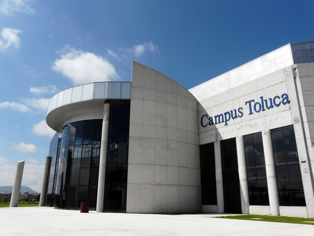
Monterrey Institute of Technology and Higher Education, Toluca
School · 3.5 km

Cine Colibrí Zinacantepec
Cinema and theater · 3.1 km
1600 Carretera a Almoloya de Juárez, Zinacantepec
Mo-Su 11:00-23:00

Museums and landmarks32

Calixtlahuaca
Monument and historic site · 7.0 km
Archaeological site in Toluca Municipality, Mexico

Cosmovitral
Museum · 8.6 km
Stained glass mural and botanical garden located in Toluca, Mexico

Fine Arts Museum of Toluca
Museum · 8.3 km
Art museum in Toluca de Lerdo, Mexico


Museo de Antropología e Historia
Museum · 3.7 km
302 Jesús Reyes Heroles, Toluca de Lerdo
Martes-Sábado 10:00 - 18:00 / Domingo 10:00 - 15:00


Clases De Baile Step By Step
Museum
Calle Sebastián Lerdo De Tejada
Destiny Escuela De Baile
Museum · 5.1 km
Avenida Profesora María Del Refugio Alejandro Tarrello
20 more on the map.
Parks, trails and playgrounds38


Nevado de Toluca National Park
Park · 14.8 km
National Park in Mexico

Paseo Matlazincas
Park · 5.7 km
Superficie en m2: 2,921
Paseo de los Matlatzincas, Toluca de Lerdo
24/7
Arroyo Cano
Park · 5.8 km
Superficie en m2: 1,552
112 Privada Lago Gatún, Toluca de Lerdo
24/7
Ayuntamiento
Park · 4.3 km
Superficie en m2: 895
Calle H. Ayuntamiento, Toluca de Lerdo
24/7
Capulines
Park · 5.5 km
Superficie en m2: 193
Calle Laguna 7 Colores, Toluca de Lerdo
24/7
El Trigo
Park · 4.6 km
Superficie en m2: 1,322
Calle El Trigo, Toluca de Lerdo
24/7
Felipe Villarelo
Park · 5.5 km
Superficie en m2: 269
Calle Felipe Villarello, Toluca de Lerdo
24/7
Ing Anselmo Camacho
Park · 4.6 km
Superficie de 1261 m2
208 Corralitos, Toluca de Lerdo
24/7
Jardín de la Asunción
Park · 5.1 km
Superficie en m2:1,699
Calle Laguna Misteriosa, Toluca
24/7
Lago Caimanero
Park · 5.5 km
Superficie en m2: 273
Calle Lago Caimanero, Toluca de Lerdo
24/7
Las Islas
Park · 5.9 km
Superficie en m2: 9,204
Boulevard Adolfo López Mateos, Toluca de Lerdo
24/7
Parque Alameda 2000
Park · 4.3 km
Superficie en m2: 950,588
s/n Boulevard Jesús Reyes Heroles, Toluca de Lerdo
24/7
26 more on the map.
Restaurants and cafes68



uno:quince
Cafe · Coffee Shop · 5.8 km
300b Calle Lago Nexpa
Mo 12:30-19:30; Tu-Sa 09:30-19:30
56 more on the map.
History
The history of the town and municipality begins about 1500 years ago at an elevation now named "Cerro de Murciélago" or Bat Mountain. The hill contained two caves that used to be filled with thousands of bats. The presence of these animals was considered a sign of fertility. The hill remained populated until the 18th century, when a plague pushed the population toward the Franciscan monastery, which functioned as a hospital. A deity named Zinacan was associated with the mountain. Shortly after the Spanish Conquest, this deity would be believed to be an incarnation of the Devil. Today, the bat population of the area is limited to a few caves in the Nevado de Toluca National Park. The mountain is mined for gravel and alongside it is the Hacienda de Santa Cruz de los Patos, which is now part of the Mexiquense College, as a research center and library.
The earliest known ethnicity in the area is the Otomi, who still are present, especially in smaller communities in the municipality such as San Luis Mextepec and Acahulaco. In the south of the municipality, there are Matlatzincas; however, there are very few. The area was conquered by the Aztecs in the latter 15th century by Axayacatl. Zinacantepec was then ruled from Tlacopan as a tributary province.
From the History section of Zinacantepec on Wikipedia, under CC BY-SA 4.0.
Where to stay8
Churches and places of worship35
Iglesia de san Isidro
Church · Roman Catholic · 3.9 km
Calle Nicolas Bravo, Zinacantepec
Parroquia de San Francisco de Asis
Church · Roman Catholic · 3.5 km
Avenida Miguel Hidalgo, San Francisco Tlalcilalcalpan
Parroquia de San Luis Mextepec
Church · Catholic · 1.6 km
Calle Reforma, Zinacantepec
Parroquia San Antonio Acahualco
Church · Roman Catholic · 4.1 km
Calle Miguel Hidalgo, San Antonio Acahualco
San Mateo
Church · Roman Catholic · 5.2 km
Nicolas Bravo, Delegacion De San Mateo Oxtotitlan
Shopping51
Aplicaciones a acavados Jilo
Hardware store · 3.1 km
Calle Valle De Bravo, Toluca
Cementos Aceros y Herramientas Tejupilco
Hardware store · 5.8 km
Toluca-temascaltepec
Taller De Carpinteria Con Venta De Madera El Polin
Hardware store · 4.6 km
Calle Parque Sierra Morelos
Gas and EV charging28
Pemex
Gas station · 5.2 km
Avenida Profesora María Del Refugio Alejandro Tarrello
Schools, colleges and libraries203
Centro De Capacitacion Para El Trabajo Industrial Número 37 15dbtoo37y
School
Calle Ignacio López Rayón
Escuela Secundaria Tecnica Numero 67 Jose Maria Luis Mora
School · 1.6 km
Cerrada 3 de Mayo, Zinacantepec
Healthcare95
Farmacia Guadalajara
Clinic and pharmacy · 4.0 km
Blvd Adolfo López Mateos, Toluca de Lerdo
Clinica De Especialidades Medicas San Luis
Clinic and pharmacy · 1.9 km
Calle Del Trabajo, Zinacantepec
Clinica de medicina familiar Nueva Oxtotitlán Iste
Clinic and pharmacy · 4.7 km
Calle Laguna 7 Colores
Consultorio De Nutricion
Clinic and pharmacy
Avenida José María Morelos, San Miguel Zinacantepec
Consultorio Gi
Clinic and pharmacy · 3.6 km
Avenida Independencia, San Francisco Tlalcilalcalpan
Consultorio Medico
Clinic and pharmacy · 4.8 km
Avenida Profesor Filiberto Navas, Toluca
Map of San Miguel Zinacantepec
250 places. The map loads OpenStreetMap tiles when you open it.
Getting there and nearby towns
Toluca International Airport (TLC) is the nearest airport with scheduled flights listed in OpenStreetMap, 19 km away.
- Toluca 9 km east, about 9 min by car
- Xonacatlán 25 km northeast, about 25 min by car
- Santiago Tianguistenco de Galeana 30 km east, about 30 min by car
- Miguel Hidalgo 59 km east, about 59 min by car
- Villa Nicolás Romero 58 km northeast, about 58 min by car
- Tlalpan 60 km east, about 1 h by car
- Ciudad López Mateos 60 km northeast, about 1 h by car
- Azcapotzalco 62 km east, about 1 h by car
- Tlalnepantla 63 km northeast, about 1 h by car
- Mexico City 66 km east, about 1 h by car
Drive times are estimates from straight-line distance, not routes.
Local news
Headlines from INDB.
Reviews, tips and questions
Loading what members have shared...
Sources and licences
- GeoNames (CC BY 4.0): population, coordinates, regions and time zone
- OpenStreetMap contributors (ODbL 1.0): places, airports, map data
- Wikidata (CC0 1.0): elevation, founding date, time zone, website, landmarks and historic places
- Wikimedia Commons (see each image): photos
- Wikipedia (CC BY-SA 4.0): overview and history text
Photo credits
- PlazaZinacantepec, Thelmadatter, CC BY-SA 3.0
- ITESM Campus Toluca (Gym), eBraulio Bañuelos, CC BY-SA 2.0
- Jardín Botánico Cosmovitral en Toluca Estado de México, Stephaya, CC BY-SA 4.0
- Bellas artes de Toluca - panoramio, Octavio Alonso Maya …, CC BY-SA 3.0
- MuseoCienciasIndusTOL, Thelmadatter, CC BY-SA 3.0
- Nevado de Toluca Peak, December 2005, Christopher Kessler, Attribution
- CatTolucaMexSt, Thelmadatter, CC BY-SA 3.0
- Museo de Numismática, Amadeus Torres, CC BY-SA 4.0
- MuseoCulturasPopulares03, Thelmadatter, CC BY-SA 3.0
- MuralKioskZin2, Thelmadatter, CC BY-SA 3.0
- KioskZinacantepec, Thelmadatter, CC BY-SA 3.0
- MuralKioskZin1, Thelmadatter, CC BY-SA 3.0
- Iglesia al costado del museo virreinal, Zahiled rivera, CC BY-SA 4.0
- ZinMuniPalace1, Thelmadatter, CC BY-SA 3.0
- ZinMuniPal2, Thelmadatter, CC BY-SA 3.0
- Fuera del museo del virreinal en Zinacantepec, Zahiled rivera, CC BY-SA 4.0
- Museo Virreinal, Zinacantepec, Subsecretaría de Turismo. Estado de México, CC BY-SA 4.0
- Balcón del museo virreinal, Zahiled rivera, CC BY-SA 4.0
- Sagrario del Antiguo Convento de San Miguel Arcángel, Richard Xingú, CC BY-SA 3.0
- Fachada del Templo y Capilla abierta del Antiguo Convento de San Miguel Arcángel (Hoy Museo Virreinal), Richard Xingú, CC BY-SA 3.0
- AltarOpenChZin, Thelmadatter, CC BY-SA 3.0
- ChapelEntVicMusZin, Thelmadatter, CC BY-SA 3.0
- CloisterBellTower, Thelmadatter, CC BY-SA 3.0
- CloisterDomeZin, Thelmadatter, CC BY-SA 3.0
- Monjes del museo virreinal, Zahiled rivera, CC BY-SA 4.0
- ExMonasteryZinacantepec, Thelmadatter, CC BY-SA 3.0
- PilgrimsEntranceZina, Thelmadatter, CC BY-SA 3.0
- Cultura Mexicana, Stephanie Sotomayor, CC BY-SA 4.0
- Calles de Valle de Bravo, Estado de México, Rosario Rogel, CC BY-SA 4.0
- Campo baldio - panoramio, Carlos Alejandro C.R…, CC BY-SA 3.0
- MÉXICO ES PASIÓN Y COLOR, José Miguel Arce Lujano, CC BY-SA 4.0
- MÉXICO ES PASIÓN, José Miguel Arce Lujano, CC BY-SA 4.0
- MusModArtToluca03, Thelmadatter, CC BY-SA 3.0
- MusModArtToluca02, Thelmadatter, CC BY-SA 3.0
- MusModArtToluca01, Thelmadatter, CC BY-SA 3.0
- Panorámica del Centro Cultural Mexiquense, RMdnss, CC BY-SA 4.0
- CCMexiquenseMMA01, Thelmadatter, CC BY-SA 3.0
- CCMexiquenseMMA02, Thelmadatter, CC BY-SA 3.0
- MuseoCulturasPopulares02, Thelmadatter, CC BY-SA 3.0
- MuseoAntroToluca01, Thelmadatter, CC BY-SA 3.0


Page built November 4, 2026. Spotted a mistake? Tell us or suggest a place.