


New Canaan, Connecticut
New Canaan is a community of 6,896 people in Connecticut, founded in 1731.
Why visit New Canaan
Townapedia lists 27 museums and landmarks, 13 parks and trails, 24 places to eat and 6 attractions in and around town.
Highlights include Turn-of-River Bridge, The Playhouse, Waveny Park and Arthur and Lyn Chivvis House.
July is the warmest month, with average highs of 85°F; January lows average 22°F, and about 34 inches of snow fall in a normal year.
Weather in New Canaan
Forecast from the National Weather Service. Full forecast
About New Canaan
New Canaan () is a town in Fairfield County, Connecticut. The population was 20,622 according to the 2020 census. The town is part of the Western Connecticut Planning Region.
From the Wikipedia article New Canaan, Connecticut (this version), under CC BY-SA 4.0.
Things to do6
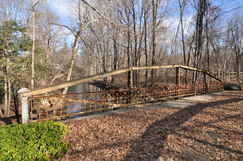
Turn-of-River Bridge
Bridge · National Register of Historic Places · 3.4 mi
Truss bridge in Connecticut, United States of America


Museums and landmarks27

Waveny Park
Monument and historic site · National Register of Historic Places · 1.3 mi
Park with 1912 mansion in New Canaan, Connecticut, USA
Arthur and Lyn Chivvis House
Monument and historic site · National Register of Historic Places · 2.9 mi
Historic house at 2 Wydendown Road in New Canaan, Connecticut

Benjamin Hait House
Monument and historic site · National Register of Historic Places · 3.2 mi
House in Stamford, Connecticut, US

Deacon John Davenport House
Monument and historic site · National Register of Historic Places · 2.2 mi
Historic house in Connecticut, United States

Durisol House
Monument and historic site · National Register of Historic Places · 1.3 mi
Historic house in New Canaan, Connecticut

Elinor and Sherman Ford House
Monument and historic site · National Register of Historic Places · 1.9 mi
Historic house in New Canaan, Connecticut

Enos Kellogg House
Monument and historic site · National Register of Historic Places · 1.8 mi
Historic house in Norwalk, Connecticut

Glass House
Museum · National Register of Historic Places · 2.0 mi
House in New Canaan, Connecticut designed by Philip Johnson

Hampton Inn
Monument and historic site · National Register of Historic Places · 1.0 mi
Listed on the National Register of Historic Places (NRHP) in Connecticut

Hanford Davenport House
Monument and historic site · National Register of Historic Places · 1.4 mi
Historic house in Connecticut, United States

Hoyt-Burwell-Morse House
Monument and historic site · National Register of Historic Places · 1.9 mi
House in New Canaan, Connecticut, United States
Isaac Davis and Marion Dalton Hall House
Monument and historic site · National Register of Historic Places · 1.4 mi
Historic house in New Canaan, Connecticut, USA
15 more on the map.
Parks, trails and playgrounds13




1 more on the map.
Restaurants and cafes24

Greens on the Go
Restaurant · Sandwich, Smoothie, Salad, Bowl, Tex-Mex, Mediterranean, Moroccan · 0.4 mi
Cali-inspired salads, grain bowls, smoothies, snacks
75 Pine Street, New Canaan
Mo-Fr 10:00-16:00

Zumbach's Gourmet Coffee
Cafe · Coffee Shop · 0.5 mi
77 Pine Street, New Canaan
Mo-Fr 07:00-17:30; Sa 08:00-17:00; Su 08:00-15:00
12 more on the map.
History
In 1731, Connecticut's colonial legislature established Canaan Parish as a religious entity in northwestern Norwalk and northeastern Stamford. The right to form a Congregational church was granted to the few families scattered through the area. As inhabitants of Norwalk or Stamford, Canaan Parish settlers still had to vote, pay some taxes—no income tax, and many other modern taxes did not yet exist—serve on juries, and file deeds in their hometowns. Because Canaan Parish was not planned as a town when it was first settled in 1731, when New Canaan was incorporated in 1801, it found itself without a central common, a main street, or a town hall.
Until the Revolutionary War, New Canaan was primarily an agricultural community; after the war, the town's major industry was shoemaking. As New Canaan's shoe business gathered momentum early in the 19th century, instead of a central village, regional settlements of clustered houses, mill, and school developed into distinct district centers. Some of the districts were centered on Ponus Ridge, West Road, Oenoke Ridge, Smith Ridge, Talmadge Hill, and Silvermine, a pattern that the village gradually outgrew.
From the History section of New Canaan, Connecticut on Wikipedia, under CC BY-SA 4.0.
Churches and places of worship8
The Congregational Church of New Canaan
Church · United Church Of Christ · 0.6 mi
The Church of Jesus Christ of Latter-day Saints
Church · Latter-Day Saints · 1.2 mi
Shopping4
Gas and EV charging2
Schools, colleges and libraries44
Healthcare2
Map of New Canaan
130 places. The map loads OpenStreetMap tiles when you open it.
Climate by month
Monthly table
| Month | High | Low | Rain | Snow |
|---|---|---|---|---|
| Jan | 38°F | 22°F | 4.3 in | 9.1 in |
| Feb | 41°F | 23°F | 3.1 in | 11.9 in |
| Mar | 49°F | 30°F | 4.7 in | 5.9 in |
| Apr | 62°F | 40°F | 4.4 in | 0.5 in |
| May | 72°F | 50°F | 4.1 in | 0.0 in |
| Jun | 80°F | 58°F | 4.9 in | 0.0 in |
| Jul | 85°F | 64°F | 3.8 in | 0.0 in |
| Aug | 83°F | 63°F | 3.8 in | 0.0 in |
| Sep | 76°F | 56°F | 5.2 in | 0.0 in |
| Oct | 64°F | 45°F | 4.6 in | 0.0 in |
| Nov | 53°F | 35°F | 4.2 in | 0.8 in |
| Dec | 43°F | 27°F | 4.4 in | 5.8 in |
U.S. Climate Normals 1991-2020 for Stamford 5 N Hcn (3 mi away), NOAA NCEI.
People and cost of living
American Community Survey 5-year estimates, 2020-2024, U.S. Census Bureau. Estimates have margins of error, larger for small towns.
Disaster history
The county has had 25 federal disaster declarations since 2000, most often for hurricanes.
- 2024-09-20: Severe Storm, Flooding, Landslides, And Mudslides (Severe Storm)
- 2024-08-21: Severe Storms, Flooding, Landslides, And Mudslides (Severe Storm)
- 2021-10-30: Remnants Of Hurricane Ida (Hurricane)
- 2021-08-22: Hurricane Henri (Hurricane)
- 2021-01-12: Tropical Storm Isaias (Hurricane)
- 2020-08-06: Tropical Storm Isaias (Hurricane)
OpenFEMA disaster declarations summaries.
Getting there and nearby towns
Westchester County Airport (HPN) is the nearest airport with scheduled flights listed in OpenStreetMap, 12 miles away.
- South Wilton 4 mi northeast, about 7 min by car
- Norwalk 5 mi southeast, about 8 min by car
- Stamford 5 mi southwest, about 8 min by car
- Darien Downtown 5 mi south, about 7 min by car
- Poplar Plains 6 mi east, about 10 min by car
- Compo 7 mi east, about 12 min by car
- Georgetown 7 mi north, about 12 min by car
- Cos Cob 8 mi southwest, about 13 min by car
- Coleytown 8 mi east, about 13 min by car
- Greens Farms 9 mi east, about 14 min by car
Drive times are estimates from straight-line distance, not routes.
Local news
Headlines from INDB, the NEMICO news database.
Reviews, tips and questions
Loading what members have shared...
Sources and licences
- NCES EDGE (Public domain): public schools
- NOAA NCEI U.S. Climate Normals 1991-2020 (Public domain): climate by month
- OpenFEMA (Public domain): disaster declarations
- OpenStreetMap contributors (ODbL 1.0): places, airports, map data
- U.S. Census Bureau (Public domain): population, income, housing, education, commute
- Wikidata (CC0 1.0): elevation, founding date, time zone, website, landmarks and historic places
- Wikimedia Commons (see each image): photos
- Wikipedia (CC BY-SA 4.0): overview and history text
Photo credits
- WavenyParkNewCanaanCt07252007, User:Noroton, Public domain
- Waveny Park, Karl Thomas Moore, CC BY-SA 4.0
- Maxwell-E-Perkins-House-New-Canaan-CT-USA, Staib, CC BY-SA 3.0
- NewCanaanCT DavisHallHouse, Magicpiano, CC BY-SA 3.0
- NewCanaanCT ChivvisHouse, Magicpiano, CC BY-SA 4.0
- Stephen-tyng-mather-house, Jack Boucher, Public domain
- NewCanaanCT FirstJohnBlackLeeHouse, Magicpiano, CC BY-SA 4.0
- Perry Avenue Bridge 011, Pedro Xing, CC0
- NewCanaanCT MarcelBreuerHouseII, Magicpiano, CC BY-SA 3.0
- Deacon John Davenport House, Zachary Groz, CC BY-SA 3.0
- StamfordCT TurnOfRiverBridge 1, Magicpiano, CC BY-SA 3.0
- SilvermineTavernMillPond08042007, Noroton at en.wikipedia, Public domain
- NewCanaanCT HanfordDavenportHouse, Magicpiano, CC BY-SA 3.0
- Enos Kellogg House, Norwalk, CT, JohnHarrington1972, CC BY-SA 3.0
- Benjamin Hait House, Zachary Groz, CC BY-SA 3.0
- NewCanaanCT HodgsonHouse, Magicpiano, CC BY-SA 4.0
- NewCanaanCT DurisolHouse, Magicpiano, CC BY-SA 3.0
- NewCanaanCT FordHouse, Magicpiano, CC BY-SA 3.0
- NewCanaanCT HoytBurwellMorseHouse, Magicpiano, CC BY-SA 4.0
- Glass House 2006, Carol M. Highsmith, Public domain
- Bendel Pond, Stamford Museum & Nature Center, CC BY-SA 3.0


Page built October 30, 2026. Spotted a mistake? Tell us or suggest a place.