


New Carrollton, Maryland
New Carrollton is a city of 13,564 people in Prince George's County, Maryland, founded in April 11, 1953.
Why visit New Carrollton
Townapedia lists 13 museums and landmarks, 7 parks and trails, 20 places to eat, 5 places to stay and 1 attraction in and around town.
Highlights include Greenbelt Arts Center, Beall's Pleasure, Calvert Hills Historic District and Greenbelt Park.
July is the warmest month, with average highs of 88°F; January lows average 22°F.
Weather in New Carrollton
Forecast from the National Weather Service. Full forecast
About New Carrollton
New Carrollton is a city in central Prince George's County, Maryland, 10 miles (16 km) east of Washington, D.C. According to the 2020 census, the population was 13,715.
From the Wikipedia article New Carrollton, Maryland (this version), under CC BY-SA 4.0.
Things to do1

Greenbelt Arts Center
Cinema and theater · 2.5 mi
Performance art theatre in the Roosevelt Center in Greenbelt, Maryland, United States
Museums and landmarks13

Beall's Pleasure
Monument and historic site · National Register of Historic Places · 2.4 mi
Historic house in Landover, Maryland, United States

Calvert Hills Historic District
Monument and historic site · National Register of Historic Places · 3.1 mi
Historic district in Maryland, United States

College Park Airport
Monument and historic site · National Register of Historic Places · 2.6 mi
Airport in College Park, Maryland, United States

Greenbelt Historic District
Monument and historic site · National Register of Historic Places · 2.5 mi
National Historic Landmark District in Prince George’s County, Maryland, United States

Harry Smith House
Monument and historic site · National Register of Historic Places · 3.0 mi
Historic house in Maryland, United States

Hilltop Manor
Monument and historic site · National Register of Historic Places · 3.2 mi
Building in Maryland, United States

Marenka House
Monument and historic site · National Register of Historic Places · 2.1 mi
Historic house at 7300 Radcliffe Drive in College Park, Maryland

O'Dea House
Monument and historic site · National Register of Historic Places · 2.8 mi
Historic house in Maryland, United States

Old Town College Park
Monument and historic site · National Register of Historic Places · 3.2 mi
Historic district in Prince George's County, MD

Riverdale Park Historic District
Monument and historic site · National Register of Historic Places · 3.2 mi
Historic residential subdivision in Riverdale Park, Maryland, United States
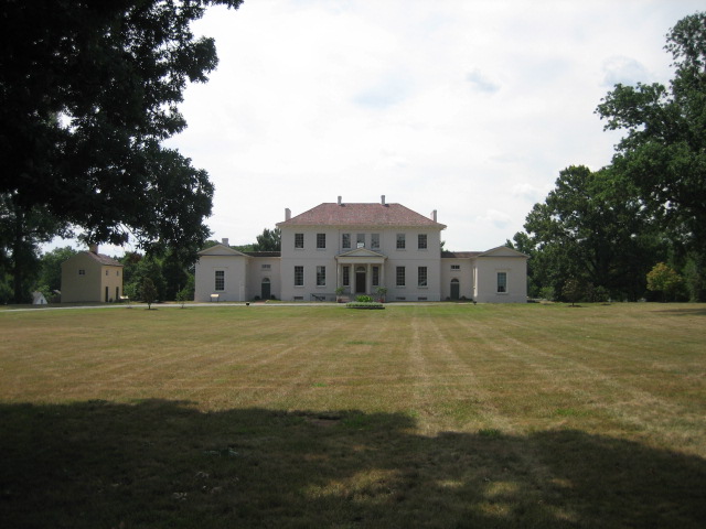
Riversdale
Monument and historic site · National Register of Historic Places · 2.9 mi
Georgian mansion in Maryland, United States

Thomas J. Calloway House
Monument and historic site · National Register of Historic Places · 3.1 mi
Historic house in Maryland, United States
1 more on the map.
Parks, trails and playgrounds7


Greenbelt Park
Park · 1.6 mi
Park in Greenbelt, Maryland, managed by the United States National Park Service

Restaurants and cafes20

House of Chickens
Restaurant · Mexican, Peruvian · 1.2 mi
7460 Annapolis Road, Hyattsville
Mo-Sa 10:00-21:00; Su 11:00-19:00
Murugan Temple Kitchen
Restaurant · Indian · 0.6 mi
6300 Princess Garden Parkway, Lanham
Fr 18:00-20:00; Sa,Su 09:00-20:00; Mo-Th off

Jamaican Country Kitchen
Restaurant · Jamaican · 1.1 mi
7572 Annapolis Road, Hyattsville

Burger King
Fast food · Burger · 0.8 mi
8903 Annapolis Road, Lanham Seabrook
Mo-Sa 06:00-22:00; Su 07:00-22:00
Domino's
Fast food · Pizza · 1.0 mi
7699 Annapolis Road, Lanham
Mo-Th 10:00-24:00; Fr-Sa 10:00-01:00; Su 10:00-24:00
Dunkin'
Fast food · Donut, Coffee Shop · 0.8 mi
7903 Annapolis Road, Lanham
Mo-Sa 05:00-21:00; Su 05:30-20:00
8 more on the map.
History
Developer Albert W. Turner acquired the former estate of horse racing figure Edward L. Mahoney after Mahoney's death in 1957 and transformed it into a planned suburb. Turner had secured a charter for the City of Carrollton from the Maryland General Assembly on April 11, 1953. He named the community after Charles Carroll of Carrollton, an early Maryland settler and the last surviving signatory of the Declaration of Independence.
Since two other Maryland communities also carried the name Carrollton, voters approved renaming the city to New Carrollton in a referendum on May 2, 1966.
From the History section of New Carrollton, Maryland on Wikipedia, under CC BY-SA 4.0.
Where to stay5
Red Roof Inn Washington, DC - Lanham
Motel and hotel · 1.0 mi
9050 Lanham Severn Road, Lanham
Churches and places of worship24
Saint Mary Catholic Church
Church · Catholic · 1.5 mi
7202 Annapolis Road, Hyattsville
Reid Temple African Methodist Episcopal Church
Church · Methodist · 0.8 mi
6705 Good Luck Road, Lanham
Brookins Faith Temple African Methodist Episcopal Church
Church · Methodist · 0.9 mi
Shopping3
Gas and EV charging5
Schools, colleges and libraries57
Healthcare2
Map of New Carrollton
137 places. The map loads OpenStreetMap tiles when you open it.
Climate by month
Monthly table
| Month | High | Low | Rain | Snow |
|---|---|---|---|---|
| Jan | 44°F | 22°F | 2.9 in | 5.7 in |
| Feb | 47°F | 23°F | 2.4 in | 5.0 in |
| Mar | 55°F | 31°F | 3.7 in | 2.5 in |
| Apr | 66°F | 41°F | 3.3 in | 0.1 in |
| May | 75°F | 51°F | 4.3 in | 0.0 in |
| Jun | 82°F | 61°F | 4.2 in | 0.0 in |
| Jul | 88°F | 66°F | 4.5 in | 0.0 in |
| Aug | 87°F | 65°F | 3.9 in | 0.0 in |
| Sep | 79°F | 57°F | 4.4 in | 0.0 in |
| Oct | 68°F | 44°F | 4.0 in | 0.0 in |
| Nov | 57°F | 33°F | 2.9 in | 0.2 in |
| Dec | 48°F | 27°F | 3.5 in | 2.3 in |
U.S. Climate Normals 1991-2020 for Glenn Dale Bell Stn Hcn (4 mi away), rain and snow from Beltsville Hcn, NOAA NCEI.
People and cost of living
American Community Survey 5-year estimates, 2020-2024, U.S. Census Bureau. Estimates have margins of error, larger for small towns.
Disaster history
Prince George's County has had 13 federal disaster declarations since 2000, most often for hurricanes.
- 2026-01-24: Severe Winter Storm (Winter Storm)
- 2020-03-26: Covid-19 Pandemic (Biological)
- 2020-03-13: Covid-19 (Biological)
- 2016-03-04: Severe Winter Storm And Snowstorm (Snowstorm)
- 2012-11-20: Hurricane Sandy (Hurricane)
- 2012-10-28: Hurricane Sandy (Hurricane)
OpenFEMA disaster declarations summaries.
Getting there and nearby towns
College Park Airport (CGS) is the nearest airport with scheduled flights listed in OpenStreetMap, 2 miles away.
- East Riverdale 2 mi west, about 3 min by car
- Greenbelt 2 mi north, about 3 min by car
- Lanham 2 mi east, about 3 min by car
- Landover 3 mi south, about 5 min by car
- College Park 4 mi northwest, about 6 min by car
- Hyattsville 4 mi west, about 7 min by car
- Glenn Dale 4 mi east, about 7 min by car
- Lake Arbor 5 mi southeast, about 7 min by car
- Chillum 5 mi west, about 9 min by car
- Adelphi 5 mi northwest, about 8 min by car
Drive times are estimates from straight-line distance, not routes.
Local news
Headlines from INDB, the NEMICO news database.
Reviews, tips and questions
Loading what members have shared...
Sources and licences
- NCES EDGE (Public domain): public schools
- NOAA NCEI U.S. Climate Normals 1991-2020 (Public domain): climate by month
- OpenFEMA (Public domain): disaster declarations
- OpenStreetMap contributors (ODbL 1.0): places, airports, map data
- U.S. Census Bureau (Public domain): population, income, housing, education, commute
- Wikidata (CC0 1.0): elevation, founding date, time zone, website, landmarks and historic places
- Wikimedia Commons (see each image): photos
- Wikipedia (CC BY-SA 4.0): overview and history text
Photo credits
- New Carrollton, Maryland, Christopher Sayan, CC BY-SA 3.0
- 2019-06-04 10 37 12 View south along the inner loop of the Capital Beltway (Interstate 95-Interstate 495) just north of Exit 20 in New Carrollton, Prince George's County, Maryland, Famartin, CC BY-SA 4.0
- 2016-07-04 08 17 42 View south along the inner loop of the Capital Beltway (Interstate 95 and Interstate 495) at Exit 20 (Maryland State Route 450-Annapolis Road, Bladensburg, Lanham) in New..., Famartin, CC BY-SA 4.0
- 2019-05-27 13 17 11 View south along the inner loop of the Capital Beltway (Interstate 95 and Interstate 495) at Exit 20 (Maryland State Route 450-Annapolis Road, Bladensburg, Lanham) in New..., Famartin, CC BY-SA 4.0
- 2019-06-04 10 25 36 View north along the outer loop of the Capital Beltway (Interstate 95-Interstate 495) just north of Exit 20 in New Carrollton, Prince George's County, Maryland, Famartin, CC BY-SA 4.0
- New Carrollton, MD, USA - panoramio, Андрей Бобровский, CC BY 3.0
- 2019-06-04 10 44 37 View west along Maryland State Route 450 (Annapolis Road) just west of Interstate 95-Interstate 495 (Capital Beltway) in New Carrollton, Prince George's County, Maryland, Famartin, CC BY-SA 4.0
- 2020-08-25 15 51 57 View east along Maryland State Route 450 (Annapolis Road) at the exit for Interstate 95-Interstate 495 SOUTH (Andrews Air Force Base, Richmond VA) in New Carrollton, Prince..., Famartin, CC BY-SA 4.0
- 2020-08-25 13 13 05 View west along Maryland State Route 450 (Annapolis Road) from the overpass for Interstate 95-Interstate 495 (Capital Beltway) in New Carrollton, Prince George's County, Maryland, Famartin, CC BY-SA 4.0
- 2021-08-04 12 41 18 View south along Maryland State Route 433 (85th Avenue) at Maryland State Route 450 (Annapolis Road) in New Carrollton, Prince George's County, Maryland, Famartin, CC BY-SA 4.0
- 2021-08-04 13 05 07 View north along Maryland State Route 433 (85th Avenue) between Harkins Road and Maryland State Route 450 (Annapolis Road) in New Carrollton, Prince George's County, Maryland, Famartin, CC BY-SA 4.0
- Riverdale Park Station Dec 08, Pubdog ( talk ), Public domain
- Riversdale 1, Quarterczar, Public domain
- Smith House Riverdale Dec 08, Pubdog ( talk ), Public domain
- Calvert Hills 1 Dec 08, Pubdog ( talk ), Public domain
- Greenbelt Community Center 2018, Carol M. Highsmith, Public domain
- Calvert Street in College Park, Ser Amantio di Nicolao, CC BY-SA 3.0
- Bealls Pleasure 1936 HABS, John O. Brostrup, Public domain
- Thomas J. Calloway House Dec 10, Pubdog, Public domain
- Hilltop Manor Entrance Dec 08, Pubdog ( talk ), Public domain
- ODea House Dec 08, Pubdog ( talk ), Public domain
- Marenka House, Farragutful, CC BY-SA 4.0
- Microstegium vimineum - Greenbelt MD, Michael Ellis, CC BY-SA 4.0
- St Ambrose, Cheverly, MD, Roberto221, CC BY-SA 4.0
- 90 degree elbow, MauryMartinez, CC BY-SA 3.0
- P trap pvc, MauryMartinez, CC BY-SA 3.0
- Better addition option, MauryMartinez, CC BY-SA 3.0
- 2016-07-04 08 17 03 View south along the inner loop of the Capital Beltway (Interstate 95 and Interstate 495) 1-2 mile north of Exit 20 (Maryland State Route 450-Annapolis Road, Bladensburg, Lanham)..., Famartin, CC BY-SA 4.0
- Murugan Temple in Lanham Maryland, Marvelmurugan, CC BY-SA 3.0
- 2019-05-27 15 00 03 View north along the outer loop of the Capital Beltway (Interstate 95 and Interstate 495) at Exit 20B (Maryland State Route 450 WEST-Annapolis Road, Bladensburg) in Seabrook..., Famartin, CC BY-SA 4.0
- 2020-08-25 13 11 19 View east along Maryland State Route 450 (Annapolis Road) from the overpass for Interstate 95-Interstate 495 (Capital Beltway) on the edge of Lanham and Seabrook in Prince..., Famartin, CC BY-SA 4.0
- 2020-08-25 13 10 23 View west along Maryland State Route 450 (Annapolis Road) at the exit for Interstate 95-Interstate 495 SOUTH (Andrews Air Force Base, Richmond VA) on the edge of Lanham and..., Famartin, CC BY-SA 4.0
- 2020-08-25 15 55 56 View east along Maryland State Route 450 (Annapolis Road) at the exit for Interstate 95-Interstate 495 NORTH (Baltimore, College Park) on the edge of Lanham and Seabrook in Prince..., Famartin, CC BY-SA 4.0
- 2020-08-25 13 06 57 View west along Maryland State Route 450 (Annapolis Road) at the exit for Interstate 95-Interstate 495 NORTH (Baltimore, College Park) on the edge of Lanham and Seabrook in Prince..., Famartin, CC BY-SA 4.0
- 2020-08-25 15 58 39 View east along Maryland State Route 450 (Annapolis Road) at Lanham Station Road and Princess Garden Parkway on the edge of Lanham and Seabrook in Prince George's County, Maryland, Famartin, CC BY-SA 4.0
- 2019-05-27 14 57 40 View north along the outer loop of the Capital Beltway (Interstate 95 and Interstate 495) at Exit 20A (Maryland State Route 450 EAST-Annapolis Road, Lanham) in Lanham, Prince..., Famartin, CC BY-SA 4.0
- 2020-08-25 13 04 53 View west along Maryland State Route 450 (Annapolis Road) at the exit for Princess Garden Parkway on the edge of Lanham and Seabrook in Prince George's County, Maryland, Famartin, CC BY-SA 4.0
- 2016-01-22 09 26 57 View north along the outer loop of the Capital Beltway (Interstate 95 and Interstate 495) at Exit 20 (Maryland State Route 450-Annapolis Road, Bladensburg, Lanham) in Lanham..., Famartin, CC BY-SA 4.0
- 2020-08-25 16 01 50 View east along Maryland State Route 450 (Annapolis Road) at the exit for Maryland State Route 564 (Lanham Severn Road) on the edge of Lanham and Seabrook in Prince George's..., Famartin, CC BY-SA 4.0
- 2006 05 12 - Good Luck Rd @ I495 - EB 03, Andrew Bossi, CC BY-SA 2.5


Page built October 30, 2026. Spotted a mistake? Tell us or suggest a place.