


Why visit New Milford
Townapedia lists 14 museums and landmarks, 13 parks and trails, 24 places to eat and 7 attractions in and around town.
Highlights include Lover's Leap Bridge, Aspetuck Hill, New Milford Center Historic District and Boardman's Bridge.
July is the warmest month, with average highs of 85°F; January lows average 20°F, and about 49 inches of snow fall in a normal year.
Weather in New Milford
Forecast from the National Weather Service. Full forecast
About New Milford
Downtown New Milford is a district/census-designated place (CDP) in Litchfield County, Connecticut, United States. It comprises the main population center within the town of New Milford. As of the 2010 census, the population of Downtown New Milford was 6,523, out of 28,142 in the entire town of New Milford.
From the Wikipedia article New Milford (CDP), Connecticut (this version), under CC BY-SA 4.0.
Things to do7

Lover's Leap Bridge
Bridge · National Register of Historic Places · 2.5 mi
Bridge in United States of America


Museums and landmarks14

New Milford Center Historic District
Monument and historic site · National Register of Historic Places
Historic district in Connecticut, United States
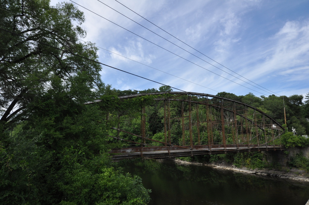
Boardman's Bridge
Bridge · National Register of Historic Places · 2.6 mi
Historic lenticular truss bridge

Bridgewater Center Historic District
Monument and historic site · National Register of Historic Places · 3.7 mi
Bridgewater, Connecticut, listed on the NRHP in Connecticut

E. A. Wildman & Co. Tobacco Warehouse
Monument and historic site · National Register of Historic Places · 0.5 mi
Building in New Milford, United States of America

Frederick S. Sanford House
Monument and historic site · National Register of Historic Places · 3.5 mi
Historic house in Connecticut, United States

Mine Hills Preserve
Monument and historic site · National Register of Historic Places · 3.8 mi
Archaeological site in Connecticut, United States

New Milford station
Monument and historic site · National Register of Historic Places · 0.5 mi
Historic railway station in New Milford, Connecticut, United States
United Bank Building
Monument and historic site · National Register of Historic Places · 0.5 mi
Building in New Milford, Connecticut, United States

Carl F. Schoverling Tobacco Warehouse
Monument and historic site · National Register of Historic Places · 0.6 mi

J. S. Halpine Tobacco Warehouse
Monument and historic site · National Register of Historic Places · 0.7 mi


Merritt Beach & Son Building
Monument and historic site · National Register of Historic Places · 0.5 mi

2 more on the map.
Parks, trails and playgrounds13

Sunny Valley Preserve
Park · 1.7 mi
Nature preserve and farm in Connecticut, United States

Pratt Valley Prese. (Ct Audubon Society) 2 Parcels
Hiking and trails · 2.0 mi
Private, Open To Public Without Fee
Pratt Valley Preserve
Hiking and trails · 2.1 mi
Private, Open To Public Without Fee
1 more on the map.
Restaurants and cafes24

Brickhouse Pizza & Restaurant
Restaurant · Pizza, Italian, Soup · 0.9 mi
33 Danbury Road
Mo-Sa 11:00-22:00; Su 12:00-21:00
Great Taste Fusion
Restaurant · Chinese · 0.4 mi
27 Main Street, New Milford
Su 12:00-22:00; Mo 07:00-22:00; Tu-Th 11:00-22:00; Fr-Sa 11:00-23:00
Greca Mediterranean Kitchen + Bar
Restaurant · Mediterranean · 0.9 mi
1 Kent Road, New Milford
Mo-Su 11:30-21:00; Su 11:30-20:30
John's Best
Restaurant · Pizza · 1.8 mi
129 Danbury Road, New Milford
Mo-Th 10:00-22:00; Fr,Sa 10:00-23:00; Su 11:00-22:00
New Oriental House
Restaurant · Chinese
44 East Street, New Milford
Tu,We,Th,Su 11:00-21:30; Fr-Sa 11:00-22:00


Jesse's Ice Cream
Ice cream · Italian · 0.4 mi
Main Street, New Milford
Mo-Th,Su 11:00-21:30; Fr,Sa 11:00-22:00
El Coyote
Restaurant · Mexican · 1.8 mi
129 Danbury Road, New Milford

12 more on the map.
Churches and places of worship4
First Congregational Church United Church of Christ
Church · United Church Of Christ · 0.4 mi
36 Main St, New Milford
St John's Episcopal Church
Church · Episcopal · 0.4 mi
7 Whittlesey Avenue, New Milford
Shopping5
Gas and EV charging3
Schools, colleges and libraries13
Healthcare3
Map of New Milford
86 places. The map loads OpenStreetMap tiles when you open it.
Climate by month
Monthly table
| Month | High | Low | Rain | Snow |
|---|---|---|---|---|
| Jan | 36°F | 20°F | 3.7 in | 15.7 in |
| Feb | 39°F | 22°F | 3.3 in | 11.0 in |
| Mar | 48°F | 29°F | 4.4 in | 10.4 in |
| Apr | 60°F | 39°F | 4.2 in | 1.7 in |
| May | 72°F | 49°F | 4.2 in | 0.0 in |
| Jun | 80°F | 59°F | 4.8 in | 0.0 in |
| Jul | 85°F | 64°F | 5.0 in | 0.0 in |
| Aug | 82°F | 63°F | 4.9 in | 0.0 in |
| Sep | 75°F | 55°F | 4.9 in | 0.0 in |
| Oct | 62°F | 43°F | 5.0 in | 0.0 in |
| Nov | 50°F | 34°F | 4.0 in | 1.9 in |
| Dec | 40°F | 26°F | 4.6 in | 8.6 in |
U.S. Climate Normals 1991-2020 for Danbury (12 mi away), NOAA NCEI.
People and cost of living
American Community Survey 5-year estimates, 2020-2024, U.S. Census Bureau. Estimates have margins of error, larger for small towns.
Disaster history
The county has had 23 federal disaster declarations since 2000, most often for hurricanes.
- 2024-09-20: Severe Storm, Flooding, Landslides, And Mudslides (Severe Storm)
- 2024-08-21: Severe Storms, Flooding, Landslides, And Mudslides (Severe Storm)
- 2021-10-30: Remnants Of Hurricane Ida (Hurricane)
- 2021-08-22: Hurricane Henri (Hurricane)
- 2021-01-12: Tropical Storm Isaias (Hurricane)
- 2020-08-06: Tropical Storm Isaias (Hurricane)
OpenFEMA disaster declarations summaries.
Getting there and nearby towns
Danbury Municipal Airport (DXR) is the nearest airport with scheduled flights listed in OpenStreetMap, 15 miles away.
- Inglenook 5 mi southwest, about 9 min by car
- New Preston 8 mi northeast, about 14 min by car
- Heritage Village 11 mi southeast, about 18 min by car
- Woodbury Center 11 mi east, about 17 min by car
- Bethlehem Village 11 mi northeast, about 18 min by car
- Danbury 13 mi south, about 21 min by car
- Newtown 13 mi south, about 20 min by car
- Bethel 15 mi south, about 24 min by car
- Waterbury 19 mi east, about 31 min by car
- Naugatuck 19 mi east, about 31 min by car
Drive times are estimates from straight-line distance, not routes.
Local news
Headlines from INDB, the NEMICO news database.
Reviews, tips and questions
Loading what members have shared...
Sources and licences
- NCES EDGE (Public domain): public schools
- NOAA NCEI U.S. Climate Normals 1991-2020 (Public domain): climate by month
- OpenFEMA (Public domain): disaster declarations
- OpenStreetMap contributors (ODbL 1.0): places, airports, map data
- U.S. Census Bureau (Public domain): population, income, housing, education, commute
- Wikidata (CC0 1.0): landmarks and historic places
- Wikimedia Commons (see each image): photos
- Wikipedia (CC BY-SA 4.0): overview and history text
Photo credits
- New Milford Downtown, AirportExpert, CC BY-SA 4.0
- New Milford, Connecticut - 5588634408, Dougtone, CC BY-SA 2.0
- New Milford, Connecticut - 5588036009, Dougtone, CC BY-SA 2.0
- New Milford, Connecticut - 5588038317, Dougtone, CC BY-SA 2.0
- New Milford, Connecticut - 5588042475, Dougtone, CC BY-SA 2.0
- New Milford, Connecticut - 5588626388, Dougtone, CC BY-SA 2.0
- New Milford station canopy, April 2010, Doug Kerr from Albany, NY, United States, CC BY-SA 2.0
- New Milford, Connecticut - 5588030737, Dougtone, CC BY-SA 2.0
- New Milford, Connecticut - 5588041511, Dougtone, CC BY-SA 2.0
- New Milford, Connecticut - 5588622836, Dougtone, CC BY-SA 2.0
- New Milford, Connecticut 052508 492, Dougtone, CC BY-SA 2.0
- New Milford, Connecticut - 5588029299, Dougtone, CC BY-SA 2.0
- New Milford, Connecticut - 5588627670, Dougtone, CC BY-SA 2.0
- New Milford, Connecticut - 5588028337, Dougtone, CC BY-SA 2.0
- New Milford, Connecticut - 5588631160, Dougtone, CC BY-SA 2.0
- BridgewaterCT EpiscopalChurch, Magicpiano, CC BY-SA 3.0
- RoxburyCT IronFurnace 7, Magicpiano, CC BY-SA 3.0
- Lover's Leap Lenticular Bridge, Spanning Housatonic River on Pumpkin Hill Road, New Milford (Litchfield County, Connecticut), Jet Lowe, Public domain
- BridgewaterCT FrederickSanfordHouse, Magicpiano, CC BY-SA 3.0
- NewMilfordCT BoardmansBridge, Magicpiano, CC BY-SA 3.0
- New Milford station under canopy, April 2010, Doug Kerr from Albany, NY, United States, CC BY-SA 2.0
- NewMilfordCT FormerWildmanTobaccoWarehouse, Doug Kerr, CC BY-SA 2.0
- NewMilfordCT CarlFSchoverlingTobaccoWarehouse, Magicpiano, CC BY-SA 3.0
- NewMilfordCT JSHalpineTobaccoWarehouse, Magicpiano, CC BY-SA 3.0
- NewMilfordCT MerrittBeachAndSonBuilding, Doug Kerr, CC BY-SA 2.0
- Suillus granulatus 107779218, Christine, CC BY 4.0
- Rhytisma acerinum 133667701, Christine, CC BY 4.0
- Stereum subtomentosum 107778356, Christine, CC BY 4.0
- Rhytisma acerinum 133667969, Christine, CC BY 4.0
- Epirrhoe alternata 197286558, Christine, CC BY 4.0
- Gyroporus cyanescens 108944184, Christine, CC BY 4.0
- Parapoynx badiusalis 102535982, Christine, CC BY 4.0
- NewMilfordCT Library, Magicpiano, CC BY-SA 3.0
- NewMilfordCT CenterHD 2, Magicpiano, CC BY-SA 3.0
- NewMilfordCT CenterHD 4, Magicpiano, CC BY-SA 3.0
- NewMilfordCT CenterHD 1, Magicpiano, CC BY-SA 3.0
- NewMilfordCT Green, Magicpiano, CC BY-SA 3.0
- NewMilfordCT TownHall, Magicpiano, CC BY-SA 3.0
- NewMilfordCT BankStreetTheater, Magicpiano, CC BY-SA 3.0
- NewMilfordCT CenterHD 3, Magicpiano, CC BY-SA 3.0


Page built October 30, 2026. Spotted a mistake? Tell us or suggest a place.