


Why visit Owatonna
Townapedia lists 34 museums and landmarks, 37 parks and trails, 41 places to eat, 10 places to stay and 1 attraction in and around town.
Highlights include Northwoods Cinema 10, Owatonna Public Library, Bridge No. L-5573 and Owatonna Country Club.
July is the warmest month, with average highs of 82°F; January lows average 5°F, and about 44 inches of snow fall in a normal year.
Weather in Owatonna
Forecast from the National Weather Service. Full forecast
About Owatonna
Owatonna () is a city in and the county seat of Steele County, Minnesota, United States. The population was 26,420 at the 2020 census. Owatonna is home to the Steele County Fairgrounds, which hosts the Steele County Free Fair in August. Interstate 35 and U.S.
From the Wikipedia article Owatonna, Minnesota (this version), under CC BY-SA 4.0.
Things to do1

Museums and landmarks34

Owatonna Public Library
Monument and historic site · National Register of Historic Places · 0.7 mi
Public library in Owatonna, Minnesota, United States

Bridge No. L-5573
Bridge · National Register of Historic Places · 3.5 mi
Bridge in United States of America

Daniel S. Piper House
Monument and historic site · National Register of Historic Places · 5.2 mi
Historic house in Minnesota, United States

Dr. John H. Adair House
Monument and historic site · National Register of Historic Places · 0.8 mi
Historic house in Owatonna, Minnesota

Ezra Abbott House
Monument and historic site · National Register of Historic Places · 0.9 mi
United States historic place
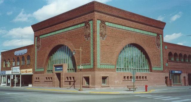
National Farmers' Bank of Owatonna
Monument and historic site · National Register of Historic Places · 0.6 mi
Historic bank building in Minnesota, USA

Owatonna City and Firemen's Hall
Monument and historic site · National Register of Historic Places · 0.7 mi
Building in Minnesota, United States
Owatonna Commercial Historic District
Monument and historic site · National Register of Historic Places · 0.6 mi
Historic district in Minnesota, USA

Pillsbury Baptist Bible College
Monument and historic site · National Register of Historic Places · 1.0 mi
Bible college in Minnesota, USA


Steele County Courthouse
Monument and historic site · National Register of Historic Places · 0.8 mi
Courthouse in Minnesota, United States

Minnesota State Public School for Dependent and Neglected Children
Museum · National Register of Historic Places
Minnesota State School Orphanage Museum
Museum
540 West Hills Circle, Owatonna
Mo-Fr 08:00-17:00, Sa-Su 13:00-17:00
22 more on the map.
Parks, trails and playgrounds37



Hazel Park
Park
This .60 acre was designated as public land in the Riverside Addition plat on December 12, 1887. This park is undeveloped due to severe...
425 Kelly Street, Owatonna
Willow Park
Park · 0.4 mi
On December 12, 1887 the land which is now identified as Willow Park was so designated as public land in the Riverside Addition plat....
305 Highland Avenue, owatonna
Crocus Park
Park
On December 12, 1887, the land which is now labeled Crocus Park was designated as public land in the Riverside Addition plat. The park...
Leo Rudolph Nature Reserve
Park · 1.3 mi
Leo Rudolph Nature Reserve is a 1.4 mile lightly trafficked loop trail located near Owatonna, Minnesota that offers scenic views and is...
25 more on the map.
Restaurants and cafes41

Basilleo's on Bridge
Restaurant · Italian Pizza · 0.8 mi
685 Suite 4 West Bridge Street
Su 11:00-22:00; Mo-Th 16:00-22:00; Fr-Sa 11:00-23:00

Godfather's Pizza
Restaurant · Pizza · 1.9 mi
116 Oakdale Street
Su-Th 11:00-21:30; Fr-Sa 11:00-22:30

Mineral Springs Brewery
Bar and pub · 0.5 mi
111 North Walnut Avenue
We-Th 16:00-21:00; Fr-Sa 12:00-22:00; Su 14:00-19:00


29 more on the map.
History
Whites settled in the Owatonna area in 1853 around the Straight River. Most of the white settlers were Yankees from New England and Upstate New York. The community was named after the Straight River, which in the Dakota language is Wakpá Owóthaŋna. A popular, but apocryphal, story is that the town is named after "Princess Owatonna", the daughter of local Native American Chief Wabena who was supposedly healed by a nearby spring's magic waters, which were said to be rich in iron and sulfur. The earliest the Owatonna area was settled was in 1854. It was platted in September 1855, incorporated as a town on August 9, 1858, and as a city on February 23, 1865.
From the History section of Owatonna, Minnesota on Wikipedia, under CC BY-SA 4.0.
Where to stay10
Churches and places of worship23
Grace Baptist Church
Church · Baptist · 1.3 mi
265 26th Street Northeast, Owatonna
New Beginnings Church
Church · Christian · 0.8 mi
332 14th Street Northeast, Owatonan
Trinity Lutheran Church
Church · Evangelical · 1.3 mi
609 Lincoln Avenue South, Owatonna
Good Shepherd Lutheran Church
Church · 1.6 mi
2500 7th Avenue Northeast, Owatonna
Seventh Day Adventist Church
Place of worship · 1.5 mi
2373 7th Avenue Northeast, Owatonna
Shopping10
Gas and EV charging8
Schools, colleges and libraries19
Healthcare2
Map of Owatonna
185 places. The map loads OpenStreetMap tiles when you open it.
Climate by month
Monthly table
| Month | High | Low | Rain | Snow |
|---|---|---|---|---|
| Jan | 22°F | 5°F | 0.9 in | 9.5 in |
| Feb | 27°F | 9°F | 0.9 in | 10.2 in |
| Mar | 40°F | 22°F | 2.0 in | 6.8 in |
| Apr | 55°F | 34°F | 3.2 in | 2.6 in |
| May | 68°F | 47°F | 4.6 in | 0.5 in |
| Jun | 78°F | 58°F | 5.3 in | 0.0 in |
| Jul | 82°F | 62°F | 4.8 in | 0.0 in |
| Aug | 79°F | 60°F | 4.8 in | 0.0 in |
| Sep | 73°F | 51°F | 3.8 in | 0.0 in |
| Oct | 59°F | 38°F | 2.5 in | 0.3 in |
| Nov | 42°F | 25°F | 1.6 in | 3.1 in |
| Dec | 28°F | 13°F | 1.1 in | 11.2 in |
U.S. Climate Normals 1991-2020 for Owatonna (0 mi away), NOAA NCEI.
People and cost of living
American Community Survey 5-year estimates, 2020-2024, U.S. Census Bureau. Estimates have margins of error, larger for small towns.
Disaster history
Steele County has had 11 federal disaster declarations since 2000, most often for floods.
- 2024-06-28: Severe Storms And Flooding (Flood)
- 2020-04-07: Covid-19 Pandemic (Biological)
- 2020-03-13: Covid-19 (Biological)
- 2019-06-12: Severe Winter Storm, Straight-Line Winds, And Flooding (Flood)
- 2016-11-02: Severe Storms And Flooding (Flood)
- 2014-07-21: Severe Storms, Straight-Line Winds, Flooding, Landslides, And Mudslides (Flood)
OpenFEMA disaster declarations summaries.
Getting there and nearby towns
Owatonna Municipal Airport (OWA) is the nearest airport with scheduled flights listed in OpenStreetMap, 2 miles away.
- Faribault 15 mi north, about 23 min by car
- Northfield 25 mi north, about 41 min by car
- Albert Lea 31 mi south, about 50 min by car
- Austin 32 mi southeast, about 51 min by car
- Mankato 37 mi west, about 1 h by car
- Rochester 38 mi east, about 1 h by car
- Farmington 39 mi north, about 1 h by car
- Lakeville 40 mi north, about 1 h by car
- North Mankato 41 mi west, about 1 h by car
- Apple Valley 45 mi north, about 1 h 15 min by car
Drive times are estimates from straight-line distance, not routes.
Local news
Headlines from INDB, the NEMICO news database.
Reviews, tips and questions
Loading what members have shared...
Sources and licences
- NCES EDGE (Public domain): public schools
- NOAA NCEI U.S. Climate Normals 1991-2020 (Public domain): climate by month
- OpenFEMA (Public domain): disaster declarations
- OpenStreetMap contributors (ODbL 1.0): places, airports, map data
- U.S. Census Bureau (Public domain): population, income, housing, education, commute
- Wikidata (CC0 1.0): elevation, founding date, time zone, website, landmarks and historic places
- Wikimedia Commons (see each image): photos
- Wikipedia (CC BY-SA 4.0): overview and history text
Photo credits
- Owatonna, Minnesota 5, Jon Platek, CC BY-SA 3.0
- OldCityHallOwatonnaMN, Jonathunder, GFDL 1.2
- Owatonna Firemen's Hall, Cardiff1921, CC BY-SA 4.0
- Red Massey Ferguson 1085 during a parade in Owatonna, Minnesota, Greg Gjerdingen from Willmar, USA, CC BY 2.0
- Owatonna, Minnesota, Wikideas1, CC0
- Three T-38 Planes at Owatonna Degner Regional Airport, Minnesota (29173873334), Tony Webster from Minneapolis, Minnesota, United States, CC BY-SA 2.0
- OwatonnaLibrary, Jonathunder, GFDL 1.2
- OwatonnaBank, Unknown author, Public domain
- 345EastBroadwayOwatonnaMN, Jonathunder, GFDL 1.2
- 2010-1021-08-BridgeL-5573, Bobak Ha'Eri, CC BY 3.0
- 2010-1021-AdairHouse, Bobak Ha'Eri, CC BY 3.0
- 2010-1021-PillsburyACampusHD-OldMain-Kelly, Bobak Ha'Eri, CC BY 3.0
- 2010-1021-DanielSPiperHouse, Bobak Ha'Eri, CC BY 3.0
- CourthouseSteeleCountyMN, Jonathunder, GFDL 1.2
- Minnesota State Public School Orphanage Museum, McGhiever, CC BY-SA 3.0
- MNorphanage, Jonathunder, CC BY-SA 3.0
- Panna Cotta (Unsplash), Karly Gomez karlygomez, CC0
- Blood Orange Chiffon Cake with Mango Curd (Unsplash), Karly Gomez karlygomez, CC0
- Happy Birthday (Unsplash), Karly Gomez karlygomez, CC0
- 19FireMensHall06, Jonathunder, GFDL 1.2
- SteeleCountyCourthouse, Jonathunder, GFDL 1.2
- Main entrance of OHS- 2014-06-10 11-41, User:Cardiff1921, CC BY-SA 3.0
- Buick LeSabre (5889155187), Greg Gjerdingen from Willmar, USA, CC BY 2.0
- 89 Buick LeSabre Limited (5889724250), Greg Gjerdingen from Willmar, USA, CC BY 2.0
- 89 Buick LeSabre Limited (5889151989), Greg Gjerdingen from Willmar, USA, CC BY 2.0
- 89 Buick LeSabre Limited (5889149851), Greg Gjerdingen from Willmar, USA, CC BY 2.0
- 89 Buick LeSabre Limited (5889721110), Greg Gjerdingen from Willmar, USA, CC BY 2.0
- 89 Buick LeSabre Limited (5889153005), Greg Gjerdingen from Willmar, USA, CC BY 2.0
- ISS035-E-6553 - View of Earth, Earth Science and Remote Sensing Unit , Lyndon B. Johnson Space Center, Public domain
- 2025TimPenny, NeroSpicy, CC BY-SA 4.0
- Town Hall - Village of Yesteryear, Myotus, CC BY-SA 4.0
- International Harvester 660 (5889118657), Greg Gjerdingen from Willmar, USA, CC BY 2.0
- IH McCormick Farmall (5889130025), Greg Gjerdingen from Willmar, USA, CC BY 2.0
- IH Farmall (5889113923), Greg Gjerdingen from Willmar, USA, CC BY 2.0
- 2010 Hyundai Accent (5889677108) (cropped), Greg Gjerdingen from Willmar, USA, CC BY 2.0
- 2010 Hyundai Accent (5889108701), Greg Gjerdingen from Willmar, USA, CC BY 2.0
- 2010 Hyundai Accent (5889677108), Greg Gjerdingen from Willmar, USA, CC BY 2.0
- 2010 Hyundai Accent (5889678108), Greg Gjerdingen from Willmar, USA, CC BY 2.0
- ISS018-E-27544 - View of Earth, Earth Science and Remote Sensing Unit , Lyndon B. Johnson Space Center, Public domain


Page built October 30, 2026. Spotted a mistake? Tell us or suggest a place.