


Pascoag, Rhode Island
Pascoag is a community of 4,410 people in Providence County, Rhode Island.
Why visit Pascoag
Townapedia lists 6 museums and landmarks, 10 parks and trails, 3 places to eat and 2 attractions in and around town.
Highlights include Oak Hill, Wolf Hill, Bridgeton School and Chepachet.
July is the warmest month, with average highs of 80°F; January lows average 18°F, and about 62 inches of snow fall in a normal year.
Weather in Pascoag
Forecast from the National Weather Service. Full forecast
About Pascoag
Pascoag (PASS-ko or PASS-kog) is a census-designated place (CDP) and village in Providence County, Rhode Island, United States. As of the 2020 census, Pascoag had a population of 4,641. Pascoag is one of eight villages that make up the town of Burrillville.
From the Wikipedia article Pascoag, Rhode Island (this version), under CC BY-SA 4.0.
Things to do2

Museums and landmarks6

Bridgeton School
Monument and historic site · National Register of Historic Places · 0.9 mi
School building in Burrillville, United States of America

Chepachet
Monument and historic site · National Register of Historic Places · 3.2 mi
Village and census-designated place in the town of Glocester, Rhode Island

Moses Taft House
Monument and historic site · National Register of Historic Places · 1.1 mi
Listed on the NRHP in Providence County

Oakland
Monument and historic site · National Register of Historic Places · 2.9 mi
Village in Burrillville, Rhode Island,
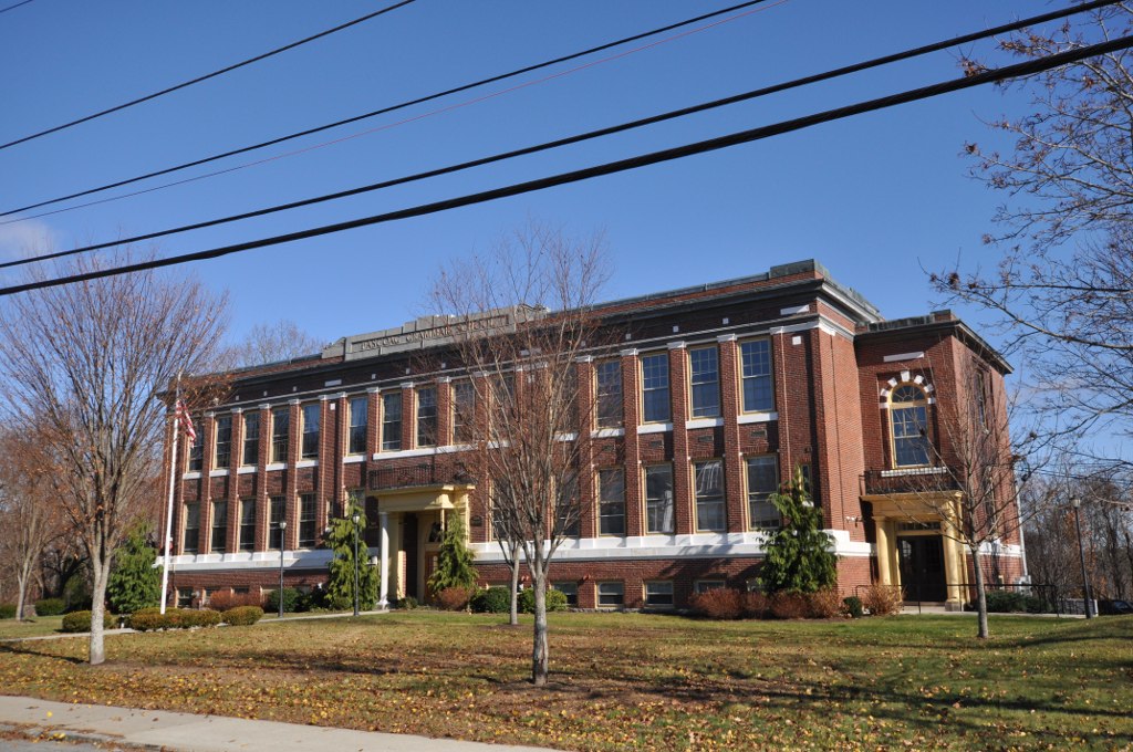
Pascoag Grammar School
Monument and historic site · National Register of Historic Places · 0.6 mi
School building in Rhode Island, United States of America
Parks, trails and playgrounds10


Restaurants and cafes3




History
The name of Burrillville's principal village, Pascoag, named after the Pascoag River upon which it is located, probably derives from an Algonquian Indian root. The Nipmuc word for snake was rendered "askug" by Roger Williams in his A Key Into the Language of America, and "askoog" by the Reverend John Eliot in his Algonquian translation of the Bible.
Pascoag can trace its origins back to the first half of the 18th century, when a saw mill and other businesses were built in what is now the village center. In the 19th century, Pascoag became a textile manufacturing town, an industry that continued until after World War II. From 1891 until the 1930s the Woonsocket and Pascoag Railroad operated trains to Pascoag, but the line (currently operated by the Providence & Worcester Railroad) now terminates in Slatersville.
The horror author HP Lovecraft set part of his story "The Horror at Red Hook" (1925) in Pascoag.
From the History section of Pascoag, Rhode Island on Wikipedia, under CC BY-SA 4.0.
Churches and places of worship6
Saint Patrick Catholic Church
Church · Roman Catholic · 1.6 mi
45 Harrisville Main Street, Harrisville
Shopping1
Schools, colleges and libraries13
Map of Pascoag
41 places. The map loads OpenStreetMap tiles when you open it.
Climate by month
Monthly table
| Month | High | Low | Rain | Snow |
|---|---|---|---|---|
| Jan | 35°F | 18°F | 4.5 in | 15.5 in |
| Feb | 38°F | 20°F | 3.9 in | 15.6 in |
| Mar | 46°F | 27°F | 5.2 in | 13.4 in |
| Apr | 58°F | 37°F | 4.7 in | 2.6 in |
| May | 68°F | 46°F | 3.8 in | 0.0 in |
| Jun | 76°F | 56°F | 4.5 in | 0.0 in |
| Jul | 80°F | 61°F | 3.6 in | 0.0 in |
| Aug | 79°F | 60°F | 4.5 in | 0.0 in |
| Sep | 72°F | 53°F | 4.4 in | 0.0 in |
| Oct | 61°F | 42°F | 5.0 in | 0.5 in |
| Nov | 50°F | 33°F | 4.5 in | 2.0 in |
| Dec | 40°F | 24°F | 5.2 in | 12.4 in |
U.S. Climate Normals 1991-2020 for N Foster 1 E (7 mi away), NOAA NCEI.
People and cost of living
American Community Survey 5-year estimates, 2020-2024, U.S. Census Bureau. Estimates have margins of error, larger for small towns.
Disaster history
Providence County has had 17 federal disaster declarations since 2000, most often for severe storms.
- 2024-03-20: Severe Storms And Flooding (Severe Storm)
- 2024-03-20: Severe Storm And Flooding (Severe Storm)
- 2024-01-07: Severe Storms, Flooding, And Tornadoes (Severe Storm)
- 2022-05-12: Severe Winter Storm And Snowstorm (Snowstorm)
- 2021-08-21: Hurricane Henri (Hurricane)
- 2020-03-30: Covid-19 Pandemic (Biological)
OpenFEMA disaster declarations summaries.
Getting there and nearby towns
North Central State Airport (SFZ) is the nearest airport with scheduled flights listed in OpenStreetMap, 11 miles away.
- Harrisville 2 mi northeast, about 3 min by car
- Chepachet 4 mi southeast, about 6 min by car
- Harmony 6 mi southeast, about 10 min by car
- Greenville 9 mi southeast, about 15 min by car
- East Douglas 9 mi north, about 14 min by car
- North Grosvenor Dale 10 mi west, about 17 min by car
- Woonsocket 11 mi east, about 18 min by car
- Webster 11 mi northwest, about 17 min by car
- Putnam 11 mi west, about 18 min by car
- Whitinsville 12 mi north, about 19 min by car
Drive times are estimates from straight-line distance, not routes.
Local news
Headlines from INDB, the NEMICO news database.
Reviews, tips and questions
Loading what members have shared...
Sources and licences
- NCES EDGE (Public domain): public schools
- NOAA NCEI U.S. Climate Normals 1991-2020 (Public domain): climate by month
- OpenFEMA (Public domain): disaster declarations
- OpenStreetMap contributors (ODbL 1.0): places, airports, map data
- U.S. Census Bureau (Public domain): population, income, housing, education, commute
- Wikidata (CC0 1.0): elevation, founding date, time zone, website, landmarks and historic places
- Wikimedia Commons (see each image): photos
- Wikipedia (CC BY-SA 4.0): overview and history text
Photo credits
- PascoagRI BridgetonSchool, User:Magicpiano, CC BY-SA 4.0
- Union Mill and office, Pascoag, Rhode Island - postcard, Unknown author Unknown author, Public domain
- Main Street, Pascoag, Rhode Island - 1908 postcard, Unknown author Unknown author, Public domain
- Pascoag station postcard (2), Unknown author Unknown author, Public domain
- Pascoag station postcard (3), Unknown author Unknown author, Public domain
- Pascoag station postcard, Unknown author Unknown author, Public domain
- North abutment of P&S bridge over the Pascoag River, December 2024, Pi.1415926535, CC BY-SA 4.0
- Remains of P&S bridge over the Pascoag River (2), December 2024, Pi.1415926535, CC BY-SA 4.0
- Remains of P&S bridge over the Pascoag River (1), December 2024, Pi.1415926535, CC BY-SA 4.0
- Church Street, Pascoag, Rhode Island - postcard, Unknown author Unknown author, Public domain
- White Mill millpond, Pascoag, Rhode Island, December 2024, Pi.1415926535, CC BY-SA 4.0
- Former P&S abutment in Pascoag (2), June 2021, Pi.1415926535, CC BY-SA 4.0
- Former P&S abutment in Pascoag (1), June 2021, Pi.1415926535, CC BY-SA 4.0
- Stone walls along Clear River in Pascoag, December 2024, Pi.1415926535, CC BY-SA 4.0
- Remains of P&S Clear River bridge in Pascoag (4), December 2024, Pi.1415926535, CC BY-SA 4.0
- Remains of P&S Clear River bridge in Pascoag (3), December 2024, Pi.1415926535, CC BY-SA 4.0
- Remains of P&S Clear River bridge in Pascoag (5), December 2024, Pi.1415926535, CC BY-SA 4.0
- Harrisville–Pascoag Pedestrian Path (2), June 2021, Pi.1415926535, CC BY-SA 4.0
- Culvert under Harrisville–Pascoag Pedestrian Path, June 2021, Pi.1415926535, CC BY-SA 4.0
- Harrisville–Pascoag Pedestrian Path (1), June 2021, Pi.1415926535, CC BY-SA 4.0
- Connector trail to Harrisville–Pascoag Pedestrian Path, June 2021, Pi.1415926535, CC BY-SA 4.0
- East end of the Harrisville–Pascoag Pedestrian Path, June 2021, Pi.1415926535, CC BY-SA 4.0
- Pascoag Extension railbed east of Harrisville (1), December 2024, Pi.1415926535, CC BY-SA 4.0
- Pascoag Extension railbed east of Harrisville (2), December 2024, Pi.1415926535, CC BY-SA 4.0
- OaklandRI MillRuin, User:Magicpiano, CC BY-SA 4.0
- Moses Taft House, Burrillville RI, John Phelan, CC BY-SA 3.0
- PascoagRI PascoagGrammarSchool, User:Magicpiano, CC BY-SA 4.0
- Chepachet general store, Swampyank at English Wikipedia, CC BY-SA 3.0
- Spergularia rubra (red sand-spurry), Burrillville, RI (32017373662), Doug McGrady from Warwick, RI, USA, CC BY 2.0
- White Mill Park footbridge (1), December 2024, Pi.1415926535, CC BY-SA 4.0
- White Mill Park footbridge (3), December 2024, Pi.1415926535, CC BY-SA 4.0
- White Mill Park footbridge (2), December 2024, Pi.1415926535, CC BY-SA 4.0
- White Mill Park footbridge (4), December 2024, Pi.1415926535, CC BY-SA 4.0
- Clear River downtown of White Mill footbridge, December 2024, Pi.1415926535, CC BY-SA 4.0
- South abutment of P&S Clear River bridge, December 2024, Pi.1415926535, CC BY-SA 4.0
- Main Street bridge abutment in Burrillville, December 2024, Pi.1415926535, CC BY-SA 4.0
- Railroad Avenue bridge, Burrilville, Rhode Island, June 2021, Pi.1415926535, CC BY-SA 4.0
- P&S railbed east of Mowry Street, June 2021, Pi.1415926535, CC BY-SA 4.0
- P&S railbed near Wilson Reservoir (1), December 2024, Pi.1415926535, CC BY-SA 4.0
- P&S cattle pass near Wilson Reservoir, December 2024, Pi.1415926535, CC BY-SA 4.0


Page built October 30, 2026. Spotted a mistake? Tell us or suggest a place.