
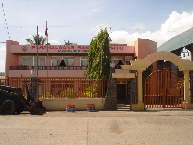


Why visit Bato
Townapedia lists 3 museums and landmarks, 5 parks and trails, 70 places to eat, 10 places to stay and 1 attraction in and around town.
Weather in Bato
Forecast from MET Norway (CC BY 4.0). Full forecast
About Bato
Bato, officially the Municipality of Bato (Rinconada Bikol: Banwāan ka Bato; Tagalog: Bayan ng Bato), is a municipality in the province of Camarines Sur, Philippines. According to the 2024 census, it has a population of 52,021 people.
From the Wikipedia article Bato, Camarines Sur (this version), under CC BY-SA 4.0.
Travel tips from other travellers: Bato on Wikivoyage (CC BY-SA 4.0).
Things to do1

Museums and landmarks3

Parks, trails and playgrounds5



Restaurants and cafes70



58 more on the map.
History
This town was formerly called as "Kaliligno" or "Caliligno" named by the natives that settled along the river area.
This small village later was elevated into a status of a town under the decree of Spanish Superior Government on February 15, 1753. Years back, a parish was already existing which was also made under the same decree. This parish adopted "The Most Holy Trinity" as its patron saint. Its feast day is celebrated every Sunday after the Pentecost. The Bato is also known for its best noodles called Pansit Bato.
From the History section of Bato, Camarines Sur on Wikipedia, under CC BY-SA 4.0.
Where to stay10
Churches and places of worship43
Iglesia ni Cristo - Lokal ng Bato
Church · Iglesia Ni Cristo · 2.2 km
Maharlika Highway
St. Michael the Archangel Chapel
Church · Roman Catholic · 5.7 km
Maharlika Highway, Nabua
Shopping11
Gas and EV charging18
Schools, colleges and libraries95
Rinconada National Technical Vocational School Annex, San Francisco Elementary School Campus
School · 8.2 km
Morning Glory Street, Iriga
Healthcare15
Map of Bato
250 places. The map loads OpenStreetMap tiles when you open it.
Getting there and nearby towns
Naga Airport (WNP) is the nearest airport with scheduled flights listed in OpenStreetMap, 28 km away.
- Nabua 6 km north, about 6 min by car
- Libon 10 km southeast, about 10 min by car
- Iriga City 10 km northeast, about 10 min by car
- Baao 11 km north, about 11 min by car
- Polangui 14 km southeast, about 14 min by car
- Bula 16 km northwest, about 16 min by car
- Oas 17 km southeast, about 17 min by car
- Buhi 18 km northeast, about 18 min by car
- Ligao 22 km southeast, about 22 min by car
- Naga 36 km northwest, about 36 min by car
Drive times are estimates from straight-line distance, not routes.
Local news
Headlines from INDB.
Reviews, tips and questions
Loading what members have shared...
Sources and licences
- GeoNames (CC BY 4.0): population, coordinates, regions and time zone
- OpenStreetMap contributors (ODbL 1.0): places, airports, map data
- Wikidata (CC0 1.0): elevation, founding date, time zone, website, landmarks and historic places
- Wikimedia Commons (see each image): photos
- Wikipedia (CC BY-SA 4.0): overview and history text
Photo credits
- Munisipyo Bato CS, The original uploader was Ringer at Central Bikol Wikipedia ., CC BY-SA 3.0
- Tilapia sa Bato, Free2barredo, CC BY-SA 4.0
- Bomba sa Bato, Free2barredo, CC BY-SA 4.0
- Traditional way of washing Clothes in Bato, Free2barredo, CC BY-SA 4.0
- Banco Santiago De Libon Bato, Free2barredo, CC BY-SA 4.0
- Boat in Lake Bato, Free2barredo, CC BY-SA 4.0
- EATHADS BURGER IN BATO, Free2barredo, CC BY-SA 4.0
- Paratarok sa Bato, Free2barredo, CC BY-SA 4.0
- PANSIT BATO, Free2barredo, CC BY-SA 4.0
- Tricycle in Bato, Free2barredo, CC BY-SA 4.0
- Bato Tilapia Landmark, Free2barredo, CC BY-SA 4.0
- Bamboo Craft in Bato Cam Sur, Free2barredo, CC BY-SA 4.0
- Saint Anthony Padua Hall, Mark Balang, CC BY-SA 4.0
- Signage in Rinconada, Free2barredo, CC BY-SA 4.0
- A MATERIAL USED IN TEACHING BATUANON DIALECT, Free2barredo, CC BY-SA 4.0
- A MATERIAL USED IN TEACHING BATUANON DIALECT 2, Free2barredo, CC BY-SA 4.0
- Michael Sisno in action, Free2barredo, CC BY-SA 4.0
- Church of Heavenly Christian in the Philippines, Free2barredo, CC BY-SA 4.0
- Sisgundo Pansit Shop, Free2barredo, CC BY-SA 4.0
- FARMERS PLANTING RICE SEEDS, Free2barredo, CC BY-SA 4.0
- Pang Gatong, Free2barredo, CC BY-SA 4.0
- HOUSE OF THE BEAUTY QUEEN VENUS RAJ, Free2barredo, CC BY-SA 4.0
- Highway in Nabua, No machine-readable author provided. Vencel assumed (based on copyright claims)., Public domain
- Nabua Public Cemetery, Free2barredo, CC BY-SA 4.0
- Kwek kwek, ShmilyDigital, CC BY-SA 4.0
- Taro Plantation in Nabua, Camarines Sur, MarvinBikolano, CC BY-SA 4.0
- Nabua National HS, Cam Sur, May 2025, Ralff Nestor Nacor, CC BY-SA 4.0
- Maharlika Highway, Nabua, Cam Sur, May 2025, Ralff Nestor Nacor, CC BY-SA 4.0
- Spamsilog, ShmilyDigital, CC BY-SA 4.0
- Team Piltik in Nabua, Free2barredo, CC BY-SA 4.0
- Camarines Sur Polyticnic College, Free2barredo, CC BY-SA 4.0
- Nabua Fire Station, Cam Sur, May 2025, Ralff Nestor Nacor, CC BY-SA 4.0
- Camarines Sur Polytechnic Colleges, Nabua, Cam Sur, May 2025, Ralff Nestor Nacor, CC BY-SA 4.0
- Chicken Pastil 01, ShmilyDigital, CC BY-SA 4.0
- Chicken Pastil 02, ShmilyDigital, CC BY-SA 4.0
- Chicken Pastil, ShmilyDigital, CC BY-SA 4.0
- Fried Kikiam, ShmilyDigital, CC BY-SA 4.0
- Chicken Tenderloin Tips, ShmilyDigital, CC BY-SA 4.0
- Beef Nachos 02, ShmilyDigital, CC BY-SA 4.0
- Beef Nachos 01, ShmilyDigital, CC BY-SA 4.0
- Nabua Veterans Park, Cam Sur, May 2025 (3), Ralff Nestor Nacor, CC BY-SA 4.0


Page built November 7, 2026. Spotted a mistake? Tell us or suggest a place.