


Consolacion, Philippines
Consolacion is a town of 48,638 people in Central Visayas, Philippines, founded in 1920.
Why visit Consolacion
Townapedia lists 3 museums and landmarks, 11 parks and trails, 196 places to eat, 24 places to stay and 6 attractions in and around town.
Highlights include Mactan–Mandaue Bridge, Bagacay Point Lighthouse and Cebu Business Park.
Weather in Consolacion
Forecast from MET Norway (CC BY 4.0). Full forecast
About Consolacion
Consolacion, officially the Municipality of Consolacion (Cebuano: Lungsod sa Consolacion; Tagalog: Bayan ng Consolacion), is a municipality in the province of Cebu, Philippines. According to the 2024 census, it has a population of 153,931 people.
From the Wikipedia article Consolacion (this version), under CC BY-SA 4.0.
Travel tips from other travellers: Consolacion on Wikivoyage (CC BY-SA 4.0).
Things to do6

Mactan–Mandaue Bridge
Bridge · 6.3 km
Bridge in Metro Cebu, Philippines

Bagacay Point Lighthouse
Lighthouse · 6.7 km
Lighthouse in the Philippines
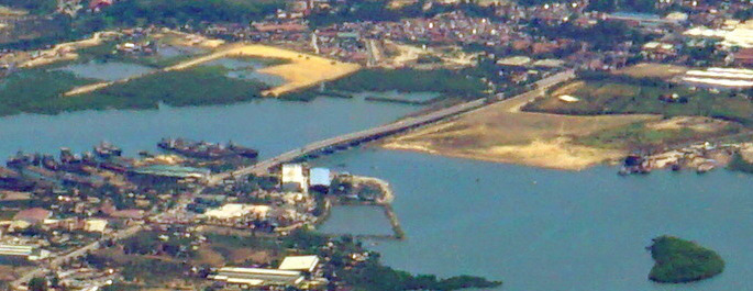
Cansaga Bay Bridge
Bridge · 3.3 km
Bridge in Mandaue and Consolacion, Cebu


Muelle Osmeña Lighthouse
Lighthouse · 7.1 km
Lighthouse in Poblacion, Lapu Lapu, Philippines

Museums and landmarks3

Parks, trails and playgrounds11


Cebu Business Park
Park · 8.4 km
Central business district in Central Visayas, Philippines


Restaurants and cafes196

Soba Kamakura
Restaurant · Japanese · 4.5 km
Greenhills Road
Tu-Su 11:30-13:00, 16:30-20:30; Mo off || "Reservations only. Call...

Otaku-Yaki Restaurant
Restaurant · Takoyaki · 2.1 km
Aurelio V. Alivio, Sr. Street, Mandaue
Mo-Su 10:00-22:00
SEOUL
Restaurant · Korean · 0.9 km
Cebu North Road
Mo-Su 10:00-19:00

Anita's Bakery
Bakery · 4.5 km
Manuel L. Quezon
Mo-Su 06:00-21:00
Mags Manok & Liempo - Ibabao-Mandaue Branch
Restaurant · Chicken, Liempo · 4.4 km
S.B. Cabahug Street, Mandaue City
Mo-Su 09:00-21:00
184 more on the map.
History
Consolacion was a component barangay first founded in 1871 with a population of 14,248. Before this, it was only a barrio of the municipality of Mandaue. The barrio, formerly named "Kampi-ig" named after a kind of crab living in mangroves, which was abundant in the area, became a separate town in 1871. However, in 1902 and 1903, unable to maintain its status as an independent municipality, it reverted to Mandaue.
In 1920, Consolacion was again made an independent municipality after a petition was accepted by the governor. So grateful were the townspeople to the Cebuano governor that they named their new town after his daughter – Consolacion – and they also chose San Narciso as their patron saint, the namesake of the governor's wife, Narcisa.
A year after the construction of the Casa Real or municipal hall, the people built their first church. Because it was made of wood, nipa, and bamboo, it was totally destroyed by a typhoon in 1888. A second one was also destroyed by a typhoon in 1892. A third one was built just before World War II, on its current site.
From the History section of Consolacion on Wikipedia, under CC BY-SA 4.0.
Where to stay24
Churches and places of worship38
The Church of Jesus Christ of Latter-day Saints
Church · Mormon · 4.6 km
Cebu North Road
Our Lady of Fatima Parish Church
Church · Roman Catholic · 2.5 km
M. C. Briones Street, Mandaue
The Church of Jesus Christ of Latter-day Saints
Church · Latter-Day Saints · 4.3 km
Governor M. Cuenco Avenue, Cebu City
Christ The King Parish Church
Church · Roman Catholic · 4.9 km
Don G. LL. Ouano Street
Shopping62
Gaisano Grand Mandaue North
Shopping center · 2.3 km
Cebu North Road, Mandaue City
Gas and EV charging58
Schools, colleges and libraries87
Mandaue City Science High School
School · 4.8 km
Don G. LL. Ouano Street, Mandaue
Exceptional Childrens Education Center - EC2
School · 4.9 km
M. Cuenco Avenue, Cebu City
Sacred Heart School - Ateneo De Cebu
School · Catholic · 3.6 km
H. Abellana Street, Mandaue
Healthcare47
Kauswagan Community Clinic and Social Center
Clinic and pharmacy · 4.6 km
Cabangahan Road
Map of Consolacion
250 places. The map loads OpenStreetMap tiles when you open it.
Getting there and nearby towns
Mactan–Cebu International Airport (CEB) is the nearest airport with scheduled flights listed in OpenStreetMap, 8 km away.
- Liloan 5 km northeast, about 5 min by car
- Mandaue City 7 km southwest, about 7 min by car
- Lapu-Lapu City 7 km south, about 7 min by car
- Cebu City 10 km southwest, about 10 min by car
- Compostela 10 km northeast, about 10 min by car
- Danao 18 km northeast, about 18 min by car
- Talisay 19 km southwest, about 19 min by car
- Minglanilla 23 km southwest, about 23 min by car
- Naga 29 km southwest, about 29 min by car
- Toledo 35 km west, about 35 min by car
Drive times are estimates from straight-line distance, not routes.
Local news
Headlines from INDB.
Reviews, tips and questions
Loading what members have shared...
Sources and licences
- GeoNames (CC BY 4.0): population, coordinates, regions and time zone
- OpenStreetMap contributors (ODbL 1.0): places, airports, map data
- Wikidata (CC0 1.0): elevation, founding date, time zone, website, landmarks and historic places
- Wikimedia Commons (see each image): photos
- Wikipedia (CC BY-SA 4.0): overview and history text
Photo credits
- Cebu coastline from the air (49537057808), Matt Kieffer from London, United Kingdom, CC BY-SA 2.0
- CityMall Consolacion (2023-09-09), PaulGorduiz106, CC BY-SA 4.0
- Consolacion Public Market (01) (2023-09-09), PaulGorduiz106, CC BY-SA 4.0
- Consolacion Public Market (02) (2023-09-09), PaulGorduiz106, CC BY-SA 4.0
- Enjoy Shopping Center at Consolacion (12-22-2022), PaulGorduiz106, CC BY-SA 4.0
- Consolacion Public Market (03) (2023-09-09), PaulGorduiz106, CC BY-SA 4.0
- Consolacion Public Market (04) (2023-09-09), PaulGorduiz106, CC BY-SA 4.0
- BPI at Consolacion (12-22-2022), PaulGorduiz106, CC BY-SA 4.0
- Central Nautical Highway at Consolacion (12-22-2022), PaulGorduiz106, CC BY-SA 4.0
- A Little Tea at SM City Consolacion (12-22-2022), PaulGorduiz106, CC BY-SA 4.0
- SM City Consolacion entrance (12-22-2022), PaulGorduiz106, CC BY-SA 4.0
- SM City Consolacion (12-22-2022), PaulGorduiz106, CC BY-SA 4.0
- Nissan dealership at SM City Consolacion (12-22-2022), PaulGorduiz106, CC BY-SA 4.0
- SM Markets at SM City Consolacion (12-22-2022), PaulGorduiz106, CC BY-SA 4.0
- SM Appliance Center at SM City Consolacion (12-22-2022), PaulGorduiz106, CC BY-SA 4.0
- Miniso at SM City Consolacion (12-22-2022), PaulGorduiz106, CC BY-SA 4.0
- National Book Store at SM City Consolacion (12-22-2022), PaulGorduiz106, CC BY-SA 4.0
- The SM Store at SM City Consolacion (12-22-2022), PaulGorduiz106, CC BY-SA 4.0
- SM City Consolacion ground floor (12-22-2022), PaulGorduiz106, CC BY-SA 4.0
- Burger Steak and Lumpia at SM City Consolacion (12-22-2022), PaulGorduiz106, CC BY-SA 4.0
- Jollibee at SM City Consolacion (12-22-2022), PaulGorduiz106, CC BY-SA 4.0
- Greenwich at SM City Consolacion (12-22-2022), PaulGorduiz106, CC BY-SA 4.0
- Chowking at SM City Consolacion (12-22-2022), PaulGorduiz106, CC BY-SA 4.0
- LBC Express at SM City Consolacion (12-22-2022), PaulGorduiz106, CC BY-SA 4.0
- South Shores at SM City Consolacion (12-22-2022), PaulGorduiz106, CC BY-SA 4.0
- Orange Brutus at SM City Consolacion (12-22-2022), PaulGorduiz106, CC BY-SA 4.0
- K-Star at SM City Consolacion (12-22-2022), PaulGorduiz106, CC BY-SA 4.0
- SM Supermarket at SM City Consolacion (01) (12-22-2022), PaulGorduiz106, CC BY-SA 4.0
- Turks at SM City Consolacion (12-22-2022), PaulGorduiz106, CC BY-SA 4.0
- Bo's Coffee at SM City Consolacion (12-22-2022), PaulGorduiz106, CC BY-SA 4.0
- SM Food Court at SM City Consolacion (01) (12-22-2022), PaulGorduiz106, CC BY-SA 4.0
- World of Fun at SM City Consolacion (12-22-2022), PaulGorduiz106, CC BY-SA 4.0
- Cyberzone entrance at SM City Consolacion (12-22-2022), PaulGorduiz106, CC BY-SA 4.0
- SM Food Court at SM City Consolacion (02) (12-22-2022), PaulGorduiz106, CC BY-SA 4.0
- Mactan-Mandaue Bridge, Mike Gonzalez ( TheCoffee ), Public domain
- Bagacay Point Lighthouse 2022 01 002, Martin Michlmayr, CC BY-SA 4.0
- Cebu coastline from the air - Cansaga Bay Bridge (cropped), Matt Kieffer from London, United Kingdom, CC BY-SA 2.0
- Marcelo Fernan Bridge, Unknown author, Public domain
- Muelle Osmeña, Tribu akru, Public domain
- Cebu Business Park skyscrapers view from Luz (Cebu City; 01-16-2024), Patrickroque01, CC BY-SA 4.0
- National Shrine of St Joseph 2022 01 004, Martin Michlmayr, CC BY-SA 4.0
- Book of Mormon English Missionary Edition Soft Cover, photo by user:Ricardo630 , cover by The Church of Jesus Christ of Latter-day Saints which is {{PD-ineligible}}, Public domain
- Cebu City after dark, Ubo Pakes from Cebu City, Philippines, CC BY 2.0


Page built November 7, 2026. Spotted a mistake? Tell us or suggest a place.