


Why visit Leon
Townapedia lists 21 museums and landmarks, 8 parks and trails, 53 places to eat, 8 places to stay and 2 attractions in and around town.
Weather in Leon
Forecast from MET Norway (CC BY 4.0). Full forecast
About Leon
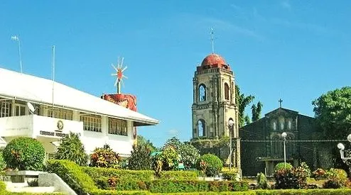
Leon, officially the Municipality of Leon (Hiligaynon: Banwa sang Leon, Kinaray-a: Banwa kang Leon, Tagalog: Bayan ng Leon), is a municipality in the province of Iloilo, Philippines. According to the 2024 census, it has a population of 52,777 people.
From the Wikipedia article Leon, Iloilo (this version), under CC BY-SA 4.0.
Things to do2

DMTT View Point
Scenic view · 4.0 km
View of Mt. Napulak (Igbaras). Mt. Pinihakang Daraga, Guinobatan (Tubungan). Iloilo City

Museums and landmarks21

Gat Andres Bonifacio Monument
Monument and historic site · 9.5 km
Guimbal-Tubungan Road
9 more on the map.
Parks, trails and playgrounds8

Restaurants and cafes53


Aunt Pauline's Cousine
Restaurant · Regional · 0.9 km
Fish;chinese;breakfast;filipino;chicken;asian




Soup-soup Higop Resto
Restaurant · Regional · 7.9 km
Batchoy,_Linaga,_Igma,_etc...
41 more on the map.
Where to stay8
Churches and places of worship27
Kingdom Hall of Jehovah's Witnesses
Church · Jehovahs Witness · 1.0 km
Bancal-Leon Road
Shopping26
Camcu Sub Standard Construction & Supply
Hardware store · 2.8 km
Leon-Antique Boundary Road
Gas and EV charging12
Schools, colleges and libraries108
Alimodian National Comprehensive High School
School · 6.6 km
Alibango Street, Alimodian
Bayag National High School
School · 4.4 km
Guimbal-Igbaras-Tubungan-Leon Road, Leon
Gelacio Allones Memorial Elementary School
School · 5.0 km
Aleosan-Alimodian Road, Alimodian
Iloilo Science and Technology University – Leon Campus
School
F. Cabarles Street, Leon
Isian Norte Elementary School
School · 3.2 km
Guimbal-Igbaras-Tubungan-Leon Road, Leon
Healthcare14
Map of Leon
250 places. The map loads OpenStreetMap tiles when you open it.
Getting there and nearby towns
Iloilo International Airport (ILO) is the nearest airport with scheduled flights listed in OpenStreetMap, 13 km away.
- Tigbauan 12 km south, about 12 min by car
- Oton 13 km southeast, about 13 min by car
- Maasin 13 km north, about 13 min by car
- Santa Barbara 17 km east, about 17 min by car
- Pavia 17 km east, about 17 min by car
- Iloilo 21 km southeast, about 21 min by car
- Janiuay 23 km northeast, about 23 min by car
- Miagao 23 km southwest, about 23 min by car
- Leganes 22 km east, about 22 min by car
- Pototan 32 km northeast, about 32 min by car
Drive times are estimates from straight-line distance, not routes.
Local news
Headlines from INDB.
Reviews, tips and questions
Loading what members have shared...
Sources and licences
- GeoNames (CC BY 4.0): population, coordinates, regions and time zone
- Mapillary (see each image): photos
- OpenStreetMap contributors (ODbL 1.0): places, airports, map data
- Wikidata (CC0 1.0): elevation, founding date, time zone, website
- Wikimedia Commons (see each image): photos
- Wikipedia (CC BY-SA 4.0): overview and history text
Photo credits
- The way to imoy falls, si kwan, CC BY 2.0
- Leon, Iloilo, Philippines - panoramio, mix villanueva, CC BY 3.0
- ISS064-E-50358 - View of Earth, Earth Science and Remote Sensing Unit , Lyndon B. Johnson Space Center, Public domain
- Tubungan Municipal Hall, Paolobon140, CC BY-SA 3.0
- ISS064-E-50357 - View of Earth, Earth Science and Remote Sensing Unit , Lyndon B. Johnson Space Center, Public domain
- ISS022-E-67307 - View of Earth, Earth Science and Remote Sensing Unit , Lyndon B. Johnson Space Center, Public domain
- Street-level photo, titoinks, CC BY-SA 4.0
Page built November 7, 2026. Spotted a mistake? Tell us or suggest a place.