



Schererville, Indiana
Schererville is a town of 29,701 people in Lake County, Indiana, founded in 1866.
Why visit Schererville
Townapedia lists 10 museums and landmarks, 42 parks and trails, 101 places to eat, 7 places to stay and 4 attractions in and around town.
Highlights include AMC Schererville 12, AMC Schereville 16, E.J. and E. Griffith Interlocking Tower and Francis P. Keilman House.
Weather in Schererville
Forecast from the National Weather Service. Full forecast
About Schererville
Schererville is a town in St. John and Center townships, Lake County, Indiana, United States. The population was 29,646 at the 2020 census It is a suburb of Chicago, located 30 miles south of the city.
From the Wikipedia article Schererville, Indiana (this version), under CC BY-SA 4.0.
Things to do4


Sauzer's Kiddieland
Monument and historic site · 1.7 mi
Former amusement park in Schererville, Indiana, United States

Museums and landmarks10
E.J. and E. Griffith Interlocking Tower
Monument and historic site · National Register of Historic Places · 2.6 mi
Signalling control in Griffith, United States of America
Francis P. Keilman House
Monument and historic site · National Register of Historic Places · 2.8 mi
Historic house in Indiana, United States
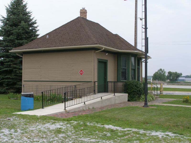
Griffith Grand Trunk Depot
Monument and historic site · National Register of Historic Places · 2.6 mi
Railway station in Griffith, the United States of America
Griffith State Bank
Monument and historic site · National Register of Historic Places · 3.3 mi
Historic building in Griffith, Indiana


Lake County Tuberculosis Sanatorium, Nurses Home and Superintendent's House
Monument and historic site · National Register of Historic Places · 4.7 mi
Building in Indiana, United States of America
Meyer's Castle
Monument and historic site · National Register of Historic Places · 2.8 mi
Building in Indiana, United States
Parks, trails and playgrounds42




30 more on the map.
Restaurants and cafes101

Grindhouse Cafe
Cafe · Coffee Shop, Deli, Local · 2.8 mi
146 North Broad Street, Griffith
Mo-Su 06:00-19:00

Pepino's Italian Restaurant
Restaurant · Italian · 1.6 mi
2410 Ontario Street, Schererville
Su, Tu-Th 11:00-20:00; Fr-Sa 11:00-21:00
Red Robin
Restaurant · Burger · 1.6 mi
1410 Indianapolis Boulevard, Schererville
Mo-Th 11:00-22:00; Fr-Sa 11:00-23:00; Su 11:00-21:00
Tandoor Cuisine of India
Restaurant · Indian · 1.5 mi
1535 Indianapolis Boulevard, Schererville
Mo-Su 11:00-14:45, 17:00-22:00
Thaal
Restaurant · Indian · 3.0 mi
827 Main Street, Schererville
Tu, Th-Su 11:00-22:00; We 10:00-22:00
Tomato Bar Pizza Bakery
Restaurant · Pizza · 2.8 mi
79 Indianapolis Boulevard, Schererville
Su-Th 11:00-21:00; Fr-Sa 11:00-22:00
Naan & Kabab
Restaurant · Indian, International · 1.6 mi
1686 Indianapolis Boulevard, Schererville
We-Mo 11:30-14:30, 16:30-22:00


89 more on the map.
History
Long before Indiana became a state, long before the founding of Schererville, people called the area the "Crossroads," as several Native American trails intersected here, that later became routes for the wagons of settlers traveling west.
One of those settlers was Nicholas Scherer, who was born in 1830 at Scheuern, today part of Tholey, Saarland, in southwestern Germany, who arrived in the U.S. in 1846. When he came to this place at the southern tip of Lake Michigan in 1865, he founded the community that bears his name.
Today, trails still cross at Schererville, the modern trails of a motorized society, U.S. Highways 41 and 30. Nearby are newer trails, I-80/94 and I-65. All these are primary transcontinental routes and gives Schererville its slogan: "Crossroads of the Nation."
Schererville's former Town Council President, Perry Ferrini, died on December 13, 2009. The Town Council's new president became Jerry Tippy, and the vacant seat held by Perry was filled by Sharon Moore on January 9, 2010.
The town of Schererville celebrated its sesquicentennial in September 2016.
From the History section of Schererville, Indiana on Wikipedia, under CC BY-SA 4.0.
Where to stay7
Holiday Inn Express & Suites Schererville
Motel and hotel · 1.7 mi
1773 Fountain Park Drive, Schererville
Churches and places of worship15
Saint George Greek Orthodox Church
Church · Greek Orthodox · 1.2 mi
528 West 77th Avenue, Schererville
Community United Reformed Church
Church · United Reformed · 1.7 mi
8405 Alexander Street, Schererville
Crossroads Community Church
Church · Nondenominational · 2.2 mi
1538 Janice Drive, Schererville
St. Michael's Church
Church · Roman Catholic · 0.5 mi
16 West Wilhelm Street, Schererville
Shopping26
Gas and EV charging11
Schools, colleges and libraries53
Griffith Senior High School
School · 3.2 mi
600 North Wiggs Street, Griffith
Healthcare8
Midwest Express Clinic Urgent Care
Clinic and pharmacy · 1.6 mi
1500 Indianapolis Boulevard, Schererville
Schererville Dialysis Center
Clinic and pharmacy · 1.6 mi
1534 Indianapolis Boulevard, Schererville
Meijer Pharmacy
Clinic and pharmacy · 3.3 mi
10138 Indianapolis Boulevard, Highland
Map of Schererville
250 places. The map loads OpenStreetMap tiles when you open it.
People and cost of living
American Community Survey 5-year estimates, 2020-2024, U.S. Census Bureau. Estimates have margins of error, larger for small towns.
Disaster history
Lake County has had 19 federal disaster declarations since 2000, most often for severe storms.
- 2026-08-25: Severe Storms, Straight-Line Winds, Tornadoes, And Flooding (Flood)
- 2026-08-15: Severe Storms, Straight-Line Winds, Tornadoes, And Flooding (Flood)
- 2026-01-24: Severe Winter Storm (Winter Storm)
- 2023-04-15: Severe Storms, Straight-Line Winds, And Tornadoes (Severe Storm)
- 2020-04-03: Covid-19 Pandemic (Biological)
- 2020-03-13: Covid-19 (Biological)
OpenFEMA disaster declarations summaries.
Getting there and nearby towns
Gary/Chicago International Airport (GYY) is the nearest airport with scheduled flights listed in OpenStreetMap, 9 miles away.
- Griffith 3 mi north, about 5 min by car
- St. John 3 mi southwest, about 5 min by car
- Dyer 4 mi west, about 6 min by car
- Highland 4 mi north, about 7 min by car
- Munster 5 mi northwest, about 9 min by car
- Merrillville 7 mi east, about 11 min by car
- Crown Point 7 mi southeast, about 12 min by car
- Lansing 8 mi northwest, about 12 min by car
- Cedar Lake 8 mi south, about 13 min by car
- Gary 9 mi northeast, about 14 min by car
Drive times are estimates from straight-line distance, not routes.
Local news
Headlines from INDB, the NEMICO news database.
Reviews, tips and questions
Loading what members have shared...
Sources and licences
- NCES EDGE (Public domain): public schools
- OpenFEMA (Public domain): disaster declarations
- OpenStreetMap contributors (ODbL 1.0): places, airports, map data
- U.S. Census Bureau (Public domain): population, income, housing, education, commute
- Wikidata (CC0 1.0): elevation, founding date, time zone, website, landmarks and historic places
- Wikimedia Commons (see each image): photos
- Wikipedia (CC BY-SA 4.0): overview and history text
Photo credits
- Schererville, JoeyBLS ( talk ), Public domain
- Lake County Sanatorium Nurses Home, Nyttend, Public domain
- EJ&E Interlocking Tower Griffith, IN P7150029 Tower, Chris Light ( talk ), CC BY-SA 3.0
- Grand Trunk Depot Griffith 7150025 Train Station, Chris Light ( talk ), CC BY-SA 3.0
- Illiana Motor Speedway 2012, Brandon Zeman, CC BY-SA 2.0
- First Detonics MTX produced, Melensdad at en.wikipedia, CC0
- Enbridge hartsdale mother duck construction, User:Visviva, Public domain
- Enbridge hartsdale mother duck tank, User:Visviva, Public domain
- Enbridge hartsdale hoosier prairie, User:Visviva, Public domain
- ISS050-E-29301 - View of Earth, Earth Science and Remote Sensing Unit , Lyndon B. Johnson Space Center, Public domain
- ISS067-E-106305 - View of Earth, Earth Science and Remote Sensing Unit , Lyndon B. Johnson Space Center, Public domain
- ISS067-E-106307 - View of Earth, Earth Science and Remote Sensing Unit , Lyndon B. Johnson Space Center, Public domain
- ISS053-E-2704 - View of Earth, Earth Science and Remote Sensing Unit , Lyndon B. Johnson Space Center, Public domain
- ISS053-E-2703 - View of Earth, Earth Science and Remote Sensing Unit , Lyndon B. Johnson Space Center, Public domain
- ISS067-E-106306 - View of Earth, Earth Science and Remote Sensing Unit , Lyndon B. Johnson Space Center, Public domain
- ISS067-E-106304 - View of Earth, Earth Science and Remote Sensing Unit , Lyndon B. Johnson Space Center, Public domain
- Erie Lackawanna Trail trailhead in Griffith, Indiana 20250628 28, David Wilson, CC BY 4.0
- Joseph Ernest Meyer House through the trees, Nyttend, Public domain
- Francis P. Keilman House, Nyttend, Public domain
- Chicago Loop and Downtown Chicago from 30,000 feet in a plane. (June 26, 2025), Czbik, CC0
- Hand injury, roelynn70, CC BY-SA 4.0
- ISS026-E-7950 - View of Earth, Earth Science and Remote Sensing Unit , Lyndon B. Johnson Space Center, Public domain
- ISS045-E-92718 - View of Earth, Earth Science and Remote Sensing Unit , Lyndon B. Johnson Space Center, Public domain
- ISS006-E-49795 - View of Illinois, Earth Science and Remote Sensing Unit , Lyndon B. Johnson Space Center, Public domain
- ISS067-E-106302 - View of Earth, Earth Science and Remote Sensing Unit , Lyndon B. Johnson Space Center, Public domain
- ISS053-E-2702 - View of Earth, Earth Science and Remote Sensing Unit , Lyndon B. Johnson Space Center, Public domain
- ISS045-E-92717 - View of Earth, Earth Science and Remote Sensing Unit , Lyndon B. Johnson Space Center, Public domain
- ISS045-E-92715 - View of Earth, Earth Science and Remote Sensing Unit , Lyndon B. Johnson Space Center, Public domain
- ISS067-E-106303 - View of Earth, Earth Science and Remote Sensing Unit , Lyndon B. Johnson Space Center, Public domain
- ISS045-E-92714 - View of Earth, Earth Science and Remote Sensing Unit , Lyndon B. Johnson Space Center, Public domain
- ISS045-E-92716 - View of Earth, Earth Science and Remote Sensing Unit , Lyndon B. Johnson Space Center, Public domain
- ISS045-E-92713 - View of Earth, Earth Science and Remote Sensing Unit , Lyndon B. Johnson Space Center, Public domain
- STS133-E-12420 - View of clouds, NASA, Public domain
- ISS022-E-76713 - View of Earth, Earth Science and Remote Sensing Unit , Lyndon B. Johnson Space Center, Public domain
- Griffith July 4th Parade 2, Paulmcdonald, CC BY-SA 3.0
- Griffith July 4th Parade 1, Paulmcdonald, CC BY-SA 3.0


Page built October 30, 2026. Spotted a mistake? Tell us or suggest a place.