


Sheffield, Ohio
Sheffield is a village of 4,380 people in Lorain County, Ohio, founded in 1817.
Why visit Sheffield
Townapedia lists 8 museums and landmarks, 35 parks and trails, 47 places to eat, 3 places to stay and 5 attractions in and around town.
Highlights include Lorain Palace Theatre, Charles Berry Bridge, 103rd Ohio Volunteer Infantry Association Barracks and Antlers Hotel.
July is the warmest month, with average highs of 85°F; January lows average 22°F, and about 44 inches of snow fall in a normal year.
Weather in Sheffield
Forecast from the National Weather Service. Full forecast
About Sheffield
Sheffield is a village in Lorain County, Ohio, United States, along the Black River. The population was 4,135 at the 2020 census. It is part of the Cleveland metropolitan area.
From the Wikipedia article Sheffield, Ohio (this version), under CC BY-SA 4.0.
Things to do5

Lorain Palace Theatre
Cinema and theater · National Register of Historic Places · 4.2 mi
Theater and former movie theater in Lorain, Ohio, United States


Lofton Henderson Memorial Bridge
Bridge · 3.4 mi
Bridge in Lorain County, Ohio

Museums and landmarks8

103rd Ohio Volunteer Infantry Association Barracks
Monument and historic site · National Register of Historic Places · 3.2 mi
United States historic place

Antlers Hotel
Monument and historic site · National Register of Historic Places · 4.5 mi
Historic hotel building in Lorain, Ohio
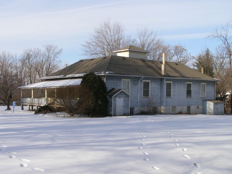
Avon Isle
Monument and historic site · National Register of Historic Places · 3.2 mi
Building in Ohio, United States

Eagles Building
Monument and historic site · National Register of Historic Places · 4.3 mi
Building in Lorain, Ohio, United States

Lorain Fire Station No. 1
Monument and historic site · National Register of Historic Places · 4.5 mi
Fire station in Lorain, Ohio

St. Ladislaus Roman Catholic Church
Monument and historic site · National Register of Historic Places · 3.0 mi
Church building in Ohio, United States of America
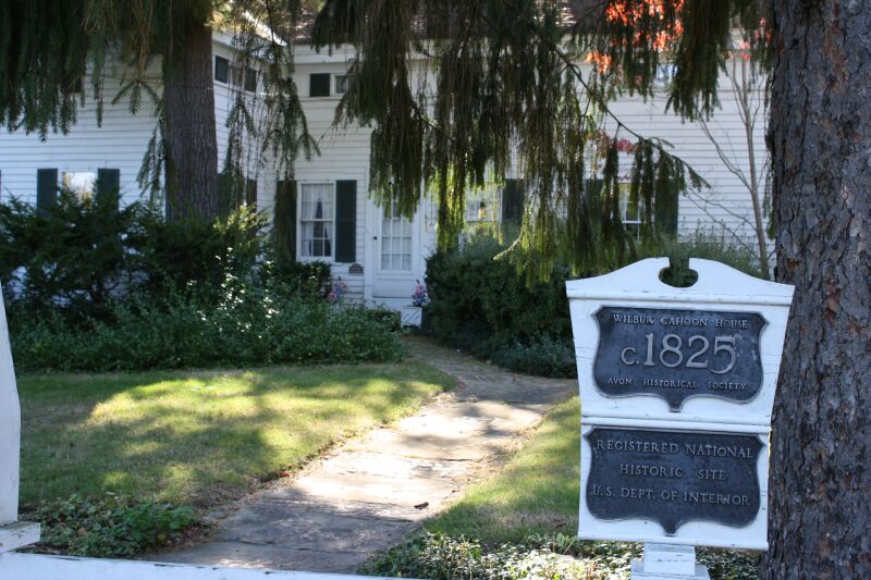


Wilbur Cahoon House
Monument and historic site · National Register of Historic Places · 3.2 mi
Historic house in Ohio, United States

Parks, trails and playgrounds35

Mercy Health Stadium
Sports field and stadium · 1.7 mi
2009 Baseball Boulevard, Avon


23 more on the map.
Restaurants and cafes47


Fiesta Habaneros Mexican Grill
Restaurant · Mexican · 2.0 mi
38790 Chester Road, Avon

Royal Grill Sushi Buffet
Restaurant · Sushi · 2.7 mi
5234 Cobblestone Road, Sheffield


The Cardinal Scoop
Ice cream · 2.4 mi
Sep-May: Mo-Fr 16:30-21:00; Sep-May: Sa,Su 12:00-21:00
35 more on the map.
Where to stay3
Extended Stay America Select Suites - Cleveland - Avon
Motel and hotel · 2.4 mi
1610 Moore Road, Avon
Fairfield Inn & Suites Cleveland Avon
Motel and hotel · 2.0 mi
39050 Colorado Avenue, Avon
Churches and places of worship22
Iglesia Pentecostal Avivamiento Final Maranatha
Church · Pentecostal · 2.3 mi
3334 Wilson Street, Lorain
Mount Zion Baptist Church
Church · Baptist · 3.0 mi
1516 East 30th Street, Lorain
New Hope Missionary Baptist Church
Church · Baptist · 3.0 mi
1512 East 28th Street, Lorain
Saint John the Baptist Ukrainian Catolic Church
Church · Ukrainian Greek Catholic · 1.4 mi
3038 Charleston Avenue, Lorain
Shopping10
Gas and EV charging15
Schools, colleges and libraries52
Constellation Schools: Lorain Community Elementary
School · 4.7 mi
1110 W 4Th St, Lorain
Constellation Schools: Lorain Community Middle
School · 4.7 mi
1110 W 4Th St, Lorain
Healthcare5
Cleveland Clinic - Sheffield Family Health Center
Clinic and pharmacy · 2.7 mi
5334 Meadow Lane, Sheffield Village
Discount Drug Mart
Clinic and pharmacy · 2.5 mi
5298 Detroit Road, Sheffield Village
University Hospitals - Avon Rehabilitation Hospital
Hospital · 2.7 mi
37900 Chester Road, Avon
Map of Sheffield
202 places. The map loads OpenStreetMap tiles when you open it.
Climate by month
Monthly table
| Month | High | Low | Rain | Snow |
|---|---|---|---|---|
| Jan | 36°F | 22°F | 2.8 in | 12.9 in |
| Feb | 40°F | 23°F | 2.4 in | 10.2 in |
| Mar | 49°F | 30°F | 3.0 in | 7.6 in |
| Apr | 63°F | 40°F | 3.8 in | 1.9 in |
| May | 73°F | 51°F | 3.9 in | 0.0 in |
| Jun | 81°F | 60°F | 4.0 in | 0.0 in |
| Jul | 85°F | 65°F | 4.1 in | 0.0 in |
| Aug | 83°F | 63°F | 4.1 in | 0.0 in |
| Sep | 77°F | 56°F | 4.0 in | 0.0 in |
| Oct | 65°F | 46°F | 3.6 in | 0.0 in |
| Nov | 52°F | 36°F | 3.0 in | 2.2 in |
| Dec | 41°F | 27°F | 3.1 in | 8.8 in |
U.S. Climate Normals 1991-2020 for Elyria 3 E (6 mi away), NOAA NCEI.
People and cost of living
American Community Survey 5-year estimates, 2020-2024, U.S. Census Bureau. Estimates have margins of error, larger for small towns.
Disaster history
Lorain County has had 9 federal disaster declarations since 2000, most often for severe storms.
- 2020-03-31: Covid-19 Pandemic (Biological)
- 2020-03-13: Covid-19 (Biological)
- 2012-06-30: Severe Storms (Severe Storm)
- 2005-09-13: Hurricane Katrina Evacuation (Hurricane)
- 2005-02-15: Severe Winter Storms, Flooding, And Mudslides (Severe Storm)
- 2004-09-19: Severe Storms And Flooding (Severe Storm)
OpenFEMA disaster declarations summaries.
Getting there and nearby towns
Cleveland Hopkins International Airport (CLE) is the nearest airport with scheduled flights listed in OpenStreetMap, 13 miles away.
- Lorain 5 mi west, about 7 min by car
- Avon 5 mi east, about 8 min by car
- Avon Lake 5 mi northeast, about 8 min by car
- Elyria 5 mi south, about 9 min by car
- North Ridgeville 6 mi southeast, about 10 min by car
- Amherst 8 mi southwest, about 13 min by car
- Westlake 8 mi east, about 14 min by car
- Bay Village 9 mi east, about 14 min by car
- North Olmsted 10 mi east, about 15 min by car
- South Amherst 11 mi southwest, about 17 min by car
Drive times are estimates from straight-line distance, not routes.
Local news
Headlines from INDB, the NEMICO news database.
Reviews, tips and questions
Loading what members have shared...
Sources and licences
- NCES EDGE (Public domain): public schools
- NOAA NCEI U.S. Climate Normals 1991-2020 (Public domain): climate by month
- OpenFEMA (Public domain): disaster declarations
- OpenStreetMap contributors (ODbL 1.0): places, airports, map data
- U.S. Census Bureau (Public domain): population, income, housing, education, commute
- Wikidata (CC0 1.0): elevation, founding date, time zone, website, landmarks and historic places
- Wikimedia Commons (see each image): photos
- Wikipedia (CC BY-SA 4.0): overview and history text
Photo credits
- Jabez and Robbins Burrell House, Nyttend, Public domain
- Sheffield Village Hall, Nyttend, Public domain
- Small boat harbor, Sheffield Lake (cropped), Rona Proudfoot, CC BY-SA 2.0
- Small boat harbor, Sheffield Lake, Rona Proudfoot, CC BY-SA 2.0
- Fire station no 1, N8hawk, CC BY-SA 3.0
- Palace Theater Lorain OH, TnrSmith, CC BY-SA 3.0
- 103rd OVI Infantry Barracks Museum, Philip Sutherland, CC BY-SA 4.0
- 2940 Stoney Ridge Wilbur Cahoon Home IMG 2073, Chris Light, CC BY-SA 3.0
- Antlers 2, N8hawk, CC BY-SA 3.0
- Eagles Bldg - Tall White facade - background P2160052, Chris Light ( talk ), CC BY-SA 3.0
- Avon Isle Park22, Chris Light, CC BY-SA 3.0
- Joseph H. Thompson, Rona Proudfoot, CC BY-SA 2.0
- French Creek Reservation toward Burrell Fort, Nyttend, Public domain
- Burrell Orchard Site from road, Nyttend, Public domain
- Eiden district from State Route 611, Nyttend, Public domain
- Johnson Steel Street Railway Company General Offices Building, Nyttend, Public domain
- Milton Garfield House, Nyttend, Public domain
- Halsey Garfield House, Nyttend, Public domain
- Lorain YMCA Building, Nyttend, Public domain
- Faygo at Discount Drug Mart, JJonahJackalope, CC BY-SA 4.0
- Pittsfield Center intersection, Nyttend, Public domain
- Steel mill in Lorain, Nyttend, Public domain
- Jay Terrell P5080730, Chris Light, CC BY-SA 4.0
- Jay Terrell P5080732, Chris Light, CC BY-SA 4.0
- Jay Terrell P5080731, Chris Light, CC BY-SA 4.0
- Jay Terrell P5080729, Chris Light, CC BY-SA 4.0
- William H. Root House, Nyttend, Public domain
- Avon Lake Ohio Veterans Park, Jason Damman, CC BY 3.0
- ISS060-E-3974 - View of Earth, Earth Science and Remote Sensing Unit, NASA Johnson Space Center, Public domain
- ISS060-E-3975 - View of Earth, Earth Science and Remote Sensing Unit, NASA Johnson Space Center, Public domain
- St Ladislaus' Catholic Church, Lorain, Nyttend, Public domain


Page built October 30, 2026. Spotted a mistake? Tell us or suggest a place.