




Shrewsbury, New Jersey
Shrewsbury is a borough of 4,179 people in Monmouth County, New Jersey.
Why visit Shrewsbury
Townapedia lists 19 museums and landmarks, 17 parks and trails, 38 places to eat, 1 place to stay and 5 attractions in and around town.
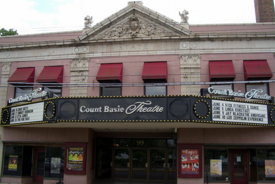
Highlights include Count Basie Theatre, Marion Huber Theater, Allen House and Anthony Reckless Estate.
July is the warmest month, with average highs of 84°F; January lows average 25°F.
Weather in Shrewsbury
Forecast from the National Weather Service. Full forecast
About Shrewsbury
Shrewsbury is a borough in eastern Monmouth County, in the U.S. state of New Jersey. Located within the heart of the northern Jersey Shore region, the borough is a bedroom community of New York City. As of the 2020 United States census, the borough's population was 4,184, its highest decennial count ever and an increase of 375 (+9.8%) from the 2010 census count of 3,809, which in turn reflected an increase of 219 (+6.1%) from the 3,590 counted in the 2000 census.
From the Wikipedia article Shrewsbury, New Jersey (this version), under CC BY-SA 4.0.
Things to do5
Count Basie Theatre
Cinema and theater · National Register of Historic Places · 1.7 mi
Theater in Red Bank, New Jersey, United States

Marion Huber Theater
Cinema and theater · 1.2 mi
Smaller stage of the Two River Theater in Red Bank, New Jersey


Two River Theater
Cinema and theater · 1.8 mi
Theater in Red Bank, New Jersey
Museums and landmarks19

Allen House
Monument and historic site · National Register of Historic Places
Historic house in Shrewsbury, New Jersey

Anthony Reckless Estate
Monument and historic site · National Register of Historic Places · 1.4 mi
Historic house in Monmouth County, New Jersey

Grover House
Monument and historic site · National Register of Historic Places · 2.8 mi
Historic house in Monmouth County, New Jersey

Little Silver
Monument and historic site · National Register of Historic Places · 0.9 mi
NJ Transit rail station

Parker Homestead
Monument and historic site · National Register of Historic Places · 1.2 mi
Building in New Jersey, United States

Red Bank
Monument and historic site · National Register of Historic Places · 1.8 mi
New Jersey Transit rail station in Red Bank, New Jersey, United States

T. Thomas Fortune House
Monument and historic site · National Register of Historic Places · 1.4 mi
Historic house in New Jersey, United States

Wardell House
Monument and historic site · National Register of Historic Places · 0.4 mi
Historic house in New Jersey, United States


Old Mill at Tinton Falls
Monument and historic site · National Register of Historic Places · 2.7 mi
Fort Monmouth Historic District
Monument and historic site · 1.2 mi
National Register of Historic Places ID: 13000764
T. Thomas Fortune Cultural Center
Monument and historic site · 1.3 mi
94 Drs. James Parker Boulevard, Red Bank

7 more on the map.
Parks, trails and playgrounds17


5 more on the map.
Restaurants and cafes38

Bombay River
Restaurant · Indian · 1.6 mi
90 Broad Street, Red Bank
Tu-Su 12:00-15:00,16:00-21:30; Mo off
Round Dough With a Hole
Restaurant · Bagel, Sandwich · 1.3 mi
700 Oceanport Avenue, Oceanport
Mo-Su 06:00-14:00



Fable Creamery
Ice cream · 1.7 mi
14 Monmouth Street, Red Bank
We,Th 12:00-20:00; Fr, Sa 12:00-21:00; Su 12:00-18:00


26 more on the map.
History
Shrewsbury was part of the Navesink Patent or Monmouth Tract granted soon after the creation of East Jersey in 1665. The tract included Shrewsbury, along with the other historic communities of Freehold Township in western Monmouth County and Middletown Township in northern Monmouth County.
When it was formed in 1693, Shrewsbury covered an area of almost 1,000 square miles (2,600 km2), extending to the north to the Navesink River, south to include all of present-day Ocean County, east to the Atlantic Ocean and west to the present-day border of Monmouth County. It retained its size and scope until 1750, when various different municipalities began to break off from it. The first of those being Stafford Township, which was formed in 1750 and taking away much of modern-day Ocean County. The Parker Homestead, one of the oldest structures in the state, was built by early settlers to the region. Many of the early settlers of the region originated from Long Island, Rhode Island, and Massachusetts.
What is now Shrewsbury Township was originally formed on October 31, 1693, and was created as a township by the Township Act of 1798 of the New Jersey Legislature on February 21, 1798. Shrewsbury Borough broke off from Shrewsbury Township, and was officially established on May 11, 1926.
From the History section of Shrewsbury, New Jersey on Wikipedia, under CC BY-SA 4.0.
Where to stay1
Churches and places of worship27
Christ Church (Episcopal), Shrewsbury
Church · National Register of Historic Places
St. James Memorial Church of Eatontown
Church · National Register of Historic Places · 1.4 mi
St. John's Episcopal Church
Church · National Register of Historic Places · 1.4 mi
Shopping10
Gas and EV charging9
Schools, colleges and libraries56
Atlantic Highlands Elementary School
School · 6.0 mi
140 First Avenue, Atlantic Highlands
Joseph M. Ferraina Early Childhood Learning Center
School · 4.0 mi
80 Avenel Boulevard, Long Branch
Healthcare5
The Kaga Academy of Aesthetic and Concierge Medicine
Clinic and pharmacy
830 Broad Street, Shrewsbury
Passport Health Shrewsbury Travel Clinic
Clinic and pharmacy · 0.8 mi
655 Shrewsbury Avenue, Shrewsbury
Map of Shrewsbury
187 places. The map loads OpenStreetMap tiles when you open it.
Climate by month
Monthly table
| Month | High | Low | Rain |
|---|---|---|---|
| Jan | 42°F | 25°F | 4.2 in |
| Feb | 43°F | 26°F | 3.3 in |
| Mar | 49°F | 32°F | 4.3 in |
| Apr | 59°F | 41°F | 3.9 in |
| May | 68°F | 51°F | 4.1 in |
| Jun | 78°F | 61°F | 4.3 in |
| Jul | 84°F | 67°F | 4.4 in |
| Aug | 82°F | 65°F | 6.3 in |
| Sep | 76°F | 59°F | 4.3 in |
| Oct | 66°F | 47°F | 4.7 in |
| Nov | 56°F | 37°F | 3.8 in |
| Dec | 47°F | 30°F | 4.8 in |
U.S. Climate Normals 1991-2020 for Long Branch-Oakhurst Hcn (4 mi away), NOAA NCEI.
People and cost of living
American Community Survey 5-year estimates, 2020-2024, U.S. Census Bureau. Estimates have margins of error, larger for small towns.
Disaster history
Monmouth County has had 16 federal disaster declarations since 2000, most often for hurricanes.
- 2021-09-05: Remnants Of Hurricane Ida (Hurricane)
- 2021-09-02: Remnants Of Hurricane Ida (Hurricane)
- 2020-12-11: Tropical Storm Isaias (Hurricane)
- 2020-03-25: Covid-19 Pandemic (Biological)
- 2020-03-13: Covid-19 (Biological)
- 2016-03-14: Severe Winter Storm And Snowstorm (Severe Storm)
OpenFEMA disaster declarations summaries.
Getting there and nearby towns
Monmouth Executive Airport (BLM) is the nearest airport with scheduled flights listed in OpenStreetMap, 11 miles away.
- Little Silver 1 mi northeast, about 2 min by car
- Red Bank 2 mi north, about 3 min by car
- Oceanport 2 mi east, about 4 min by car
- Eatontown 2 mi south, about 4 min by car
- Fair Haven 3 mi north, about 4 min by car
- Fairview 3 mi northwest, about 5 min by car
- Rumson 4 mi northeast, about 6 min by car
- Long Branch 4 mi southeast, about 7 min by car
- Lincroft 4 mi west, about 6 min by car
- Monmouth Beach 4 mi east, about 6 min by car
Drive times are estimates from straight-line distance, not routes.
Local news
Headlines from INDB, the NEMICO news database.
Reviews, tips and questions
Loading what members have shared...
Sources and licences
- NCES EDGE (Public domain): public schools
- NOAA NCEI U.S. Climate Normals 1991-2020 (Public domain): climate by month
- OpenFEMA (Public domain): disaster declarations
- OpenStreetMap contributors (ODbL 1.0): places, airports, map data
- U.S. Census Bureau (Public domain): population, income, housing, education, commute
- Wikidata (CC0 1.0): elevation, founding date, time zone, website, landmarks and historic places
- Wikimedia Commons (see each image): photos
- Wikipedia (CC BY-SA 4.0): overview and history text
Photo credits
- Episcopalian church in Shrewsbury New Jersey on Route 35, Tomwsulcer, CC0
- AllenHouseShrewsburyNJ, ClassicLady, CC BY-SA 3.0
- Fisk Chapel (7), Apc106, CC BY-SA 3.0
- Basie theatre, Wikijazz at English Wikipedia, Public domain
- St. James Memorial Church of Eatontown, akaBuddy, CC BY-SA 3.0
- Grover House, Middletown, NJ, USA 2, ScottCAbel, CC BY-SA 4.0
- LSticketbooth, Wikijazz at English Wikipedia, Public domain
- Anthony Reckless Estate, Red Bank, New Jersey (3969287329), Jazz Guy from New Jersey, United States, CC BY 2.0
- Parker Homestead (1), Apc106, CC BY-SA 3.0
- 7.9.12RedBankRailStationByLuigiNovi4, Nightscream, CC BY 3.0
- Wardell House, Ashley Blalock, CC BY-SA 3.0
- St. John's Episcopal Church (2), Apc106, CC BY-SA 3.0
- Old Mill at Tinton Falls, Ashley Blalock, CC BY-SA 3.0
- TRTCExterior 30 compress, Jkamouh, Public domain

Page built October 30, 2026. Spotted a mistake? Tell us or suggest a place.