


South Amboy, New Jersey
South Amboy is a city of 9,989 people in Middlesex County, New Jersey.
Why visit South Amboy
Townapedia lists 15 museums and landmarks, 15 parks and trails, 18 places to eat, 2 places to stay and 6 attractions in and around town.
Highlights include Driscoll Bridge, Edison Bridge, Great Beds Light and Proprietary House.
July is the warmest month, with average highs of 86°F; January lows average 23°F, and about 29 inches of snow fall in a normal year.
Weather in South Amboy
Forecast from the National Weather Service. Full forecast
About South Amboy
South Amboy is a city in Middlesex County, in the U.S. state of New Jersey, located on Raritan Bay. As of the 2020 United States census, the city's population was 9,411, an increase of 780 (+9.0%) from the 2010 census count of 8,631, which in turn reflected an increase of 718 (+9.1%) from the 7,913 counted in the 2000 census.
From the Wikipedia article South Amboy, New Jersey (this version), under CC BY-SA 4.0.
Things to do6

Driscoll Bridge
Bridge · 1.8 mi
Toll bridge in New Jersey carrying the Garden State Parkway

Morgan Draw
Bridge · 2.1 mi
Bridge in Morgan and Laurence Harbor, New Jersey
Outerbridge Crossing
Bridge · 3.0 mi
Bridge between New Jersey and New York

Raritan Bay Drawbridge
Bridge · 0.5 mi
Bridge in United States of America

Museums and landmarks15

Great Beds Light
Lighthouse · National Register of Historic Places · 1.4 mi
Lighthouse in New Jersey, United States

Proprietary House
Museum · National Register of Historic Places · 1.2 mi
Historic building in Perth Amboy, New Jersey
149 Kearny Avenue, Perth Amboy
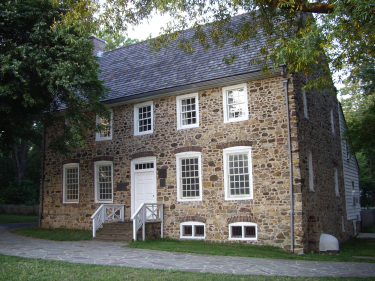
Conference House
Monument and historic site · National Register of Historic Places · 1.7 mi
Staten Island, New York location listed on National Register of Historic Places

Kearny Cottage
Monument and historic site · National Register of Historic Places · 1.4 mi
Historic house in New Jersey, United States

Perth Amboy
Monument and historic site · National Register of Historic Places · 1.5 mi
NJ Transit railway station

Perth Amboy City Hall and Surveyor General's Office
Monument and historic site · National Register of Historic Places · 1.4 mi
Historic buildings in Perth Amboy, New Jersey

Perth Amboy Public Library
Monument and historic site · National Register of Historic Places · 1.6 mi
Public library in Perth Amboy, New Jersey

Ward's Point
Monument and historic site · National Register of Historic Places · 1.6 mi
Southernmost point in the State of New York
Eagleswood Military Academy
Monument and historic site · National Register of Historic Places · 1.8 mi

Perth Amboy Ferry Slip
Monument and historic site · National Register of Historic Places · 1.6 mi


3 more on the map.
Parks, trails and playgrounds15

Conference House Park
Park · 1.7 mi
Park in the United States of America

3 more on the map.
Restaurants and cafes18

Costa Verde
Restaurant · Portuguese, Spanish · 1.0 mi
6039 State Route 35, South Amboy
Mo-Su 11:30-14:00
Hung Ling Chinese Food
Restaurant · Chinese · 1.1 mi
521 Raritan Street, Sayreville
Mo-Th 11:00-20:30; Fr-Sa 11:00-23:10
Nunzio's Kitchen
Restaurant · Pizza · 1.1 mi
521 Raritan Street, Sayreville
Mo-Sa 11:00-20:00; Su closed

Broadway Diner
Restaurant · Italian, American
126 North Broadway Street, South Amboy
Tu-Su 08:00-14:00

Dunkin' Donuts/Baskin Robbins
Cafe · Coffee Shop, Ice Cream, Donut
139-145 S Broadway, South Amboy
05:00-20:00
Classique Restaurant
Restaurant · Italian · 1.1 mi
521 Raritan Street, Sayreville
6 more on the map.
History
First settled by the Lenape Native Americans, who called the area around Perth Amboy by the name "Ompoge" (meaning "level ground"), the settlement ultimately became a key port for commerce between Lower New York Bay and Philadelphia, connected first by stagecoach and eventually by railroad. The city was initially founded as a village by Dutch fishermen known as Radford's Ferry, but later become a key city to safeguard New Amsterdam from the British. When settled by Europeans in 1684, the city was named New Perth in honor of James Drummond, Earl of Perth, one of the associates of a company of Scottish proprietaries. The Algonquian language name was corrupted to Ambo, or Point Amboy, and eventually a combination of the native and colonial names was used. South Amboy is mentioned during the Revolutionary War in letters to and from George Washington referring to an "officer stationed on the South Amboy shore" and by General Washington himself writing that he was "now in Jersey" and suggesting the enemy "may proceed to South Amboy". Once known as Radford's Ferry, as well as the South Ward of Perth Amboy, South Amboy became one of the earliest townships around 1685 as well as one of the largest at 18 miles long and six miles wide.
From the History section of South Amboy, New Jersey on Wikipedia, under CC BY-SA 4.0.
Where to stay2
Churches and places of worship21
Simpson United Methodist Church
Church · National Register of Historic Places · 1.6 mi
St. Peter's Episcopal Church
Church · National Register of Historic Places · 1.3 mi
Saint Demetrios Greek Orthodox Church
Church · Greek Orthodox · 0.9 mi
41-47 Wisteria Street, Perth Amboy
Saint Peters Episcopal Church
Church · Episcopal · 1.3 mi
183 Rector Street, Perth Amboy
Everlasting Strength Ministries Hope Chapel
Church · Nondenominational · 0.4 mi
241 2nd Street, South Amboy
First Presbyterian Church of South Amboy
Church · Presbyterian Church Usa
150 North Broadway Street, South Amboy
Shopping5
YCapellan Custom Balloons Gifts & More
Shop · 1.4 mi
261 Madison Avenue, Perth Amboy
Schools, colleges and libraries50
South Amboy Middle High School
School · 0.6 mi
200 Governor Hoffman Plaza, South Amboy
Academy For Urban Leadership Charter School
School · 2.3 mi
612 Amboy Ave, Perth Amboy
Benjamin Franklin Elementary School
School · 5.5 mi
2485 Woodbridge Avenue, Edison
Healthcare3
Map of South Amboy
135 places. The map loads OpenStreetMap tiles when you open it.
Climate by month
Monthly table
| Month | High | Low | Rain | Snow |
|---|---|---|---|---|
| Jan | 40°F | 23°F | 3.7 in | 8.3 in |
| Feb | 43°F | 24°F | 3.0 in | 9.3 in |
| Mar | 51°F | 31°F | 4.4 in | 5.2 in |
| Apr | 62°F | 41°F | 3.9 in | 0.6 in |
| May | 72°F | 51°F | 4.0 in | 0.0 in |
| Jun | 81°F | 60°F | 4.8 in | 0.0 in |
| Jul | 86°F | 66°F | 4.8 in | 0.0 in |
| Aug | 85°F | 64°F | 4.7 in | 0.0 in |
| Sep | 78°F | 56°F | 4.2 in | 0.0 in |
| Oct | 66°F | 44°F | 4.1 in | 0.2 in |
| Nov | 56°F | 35°F | 3.4 in | 0.5 in |
| Dec | 45°F | 28°F | 4.5 in | 4.9 in |
U.S. Climate Normals 1991-2020 for New Brunswick 3 Se Hcn (8 mi away), NOAA NCEI.
People and cost of living
American Community Survey 5-year estimates, 2020-2024, U.S. Census Bureau. Estimates have margins of error, larger for small towns.
Disaster history
Middlesex County has had 17 federal disaster declarations since 2000, most often for hurricanes.
- 2021-09-05: Remnants Of Hurricane Ida (Hurricane)
- 2021-09-02: Remnants Of Hurricane Ida (Hurricane)
- 2020-03-25: Covid-19 Pandemic (Biological)
- 2020-03-13: Covid-19 (Biological)
- 2016-03-14: Severe Winter Storm And Snowstorm (Severe Storm)
- 2012-10-30: Hurricane Sandy (Hurricane)
OpenFEMA disaster declarations summaries.
Getting there and nearby towns
Linden Airport (LDJ) is the nearest airport with scheduled flights listed in OpenStreetMap, 9 miles away.
- Perth Amboy 2 mi north, about 4 min by car
- Keasbey 2 mi northwest, about 4 min by car
- Sayreville 3 mi southwest, about 5 min by car
- Hopelawn 3 mi north, about 5 min by car
- Madison Park 3 mi south, about 5 min by car
- Laurence Harbor 3 mi south, about 5 min by car
- Fords 4 mi northwest, about 6 min by car
- Sewaren 4 mi north, about 6 min by car
- Woodbridge 4 mi north, about 7 min by car
- Cliffwood Beach 4 mi southeast, about 7 min by car
Drive times are estimates from straight-line distance, not routes.
Local news
Headlines from INDB, the NEMICO news database.
Reviews, tips and questions
Loading what members have shared...
Sources and licences
- NCES EDGE (Public domain): public schools
- NOAA NCEI U.S. Climate Normals 1991-2020 (Public domain): climate by month
- OpenFEMA (Public domain): disaster declarations
- OpenStreetMap contributors (ODbL 1.0): places, airports, map data
- U.S. Census Bureau (Public domain): population, income, housing, education, commute
- Wikidata (CC0 1.0): elevation, founding date, time zone, website, landmarks and historic places
- Wikimedia Commons (see each image): photos
- Wikipedia (CC BY-SA 4.0): overview and history text
Photo credits
- Downtown South Amboy, NJ, Mr. Matté (if there is an issue with this image, contact me using this image's Commons talk page , my Commons user talk page , or my English Wikipedia user talk page ; I'll know about it a lot faster), CC BY-SA 3.0
- South Amboy station main entry, Reddeleon, CC0
- South Amboy station September 11 memorial, Reddeleon, CC0
- South Amboy station September 11 memorial plaque, Reddeleon, CC0
- Broadway sb, South Amboy, NJ, Dec. 2025, Mr. Matté (if there is an issue with this image, contact me using this image's Commons talk page , my Commons user talk page , or my English Wikipedia user talk page ; I'll know about it a lot faster), CC BY-SA 4.0
- GG1 4873 at South Amboy NJ, WES, CC BY 2.0
- Broadway nb, South Amboy, NJ, Dec. 2025, Mr. Matté (if there is an issue with this image, contact me using this image's Commons talk page , my Commons user talk page , or my English Wikipedia user talk page ; I'll know about it a lot faster), CC BY-SA 4.0
- South Amboy Nj, Chester Cory Roberts Ii, CC BY 3.0
- South Amboy NJ - panoramio, Zdenek Gazda, CC BY-SA 3.0
- South Amboy, NJ post office, Dec. 2025, Mr. Matté (if there is an issue with this image, contact me using this image's Commons talk page , my Commons user talk page , or my English Wikipedia user talk page ; I'll know about it a lot faster), CC BY-SA 4.0
- Middlesex CR 615 sb, South Amboy, NJ, Dec. 2025, Mr. Matté (if there is an issue with this image, contact me using this image's Commons talk page , my Commons user talk page , or my English Wikipedia user talk page ; I'll know about it a lot faster), CC BY-SA 4.0
- 2020-10-09 08 55 09 View south along Middlesex County Route 535 (Raritan Street) at U.S. Route 9 and New Jersey State Route 35 in South Amboy, Middlesex County, New Jersey, Famartin, CC BY-SA 4.0
- 2018-05-21 10 57 30 View south along U.S. Route 9 and New Jersey State Route 35 at Washington Road in South Amboy, Middlesex County, New Jersey, Famartin, CC BY-SA 4.0
- 2020-08-14 10 18 17 View south along U.S. Route 9 and New Jersey State Route 35 at the exit for U.S. Route 9 SOUTH (Freehold, Atlantic City) in South Amboy, Middlesex County, New Jersey, Famartin, CC BY-SA 4.0
- 2020-08-14 10 17 21 View south along U.S. Route 9 and New Jersey State Route 35 at the exit for U.S. Route 9 SOUTH (Freehold, Atlantic City) in South Amboy, Middlesex County, New Jersey, Famartin, CC BY-SA 4.0
- 2020-08-22 13 09 45 View north along U.S. Route 9 at the exit for Main Street (South Amboy) in South Amboy, Middlesex County, New Jersey, Famartin, CC BY-SA 4.0
- 2018-05-21 10 19 35 View north along U.S. Route 9 at the junction with New Jersey State Route 35 and Main Street in South Amboy, Middlesex County, New Jersey, Famartin, CC BY-SA 4.0
- 2021-09-26 11 23 50 View south along Middlesex County Route 535 (Raritan Street) from the overpass for U.S. Route 9 and New Jersey State Route 35 in South Amboy, Middlesex County, New Jersey, Famartin, CC BY-SA 4.0
- 2021-09-26 11 26 00 View north along Middlesex County Route 535 (Raritan Street) from the overpass for U.S. Route 9 and New Jersey State Route 35 in South Amboy, Middlesex County, New Jersey, Famartin, CC BY-SA 4.0
- 2020-10-09 16 03 29 View north along Middlesex County Route 535 (Raritan Street) at U.S. Route 9 and New Jersey State Route 35 in South Amboy, Middlesex County, New Jersey, Famartin, CC BY-SA 4.0
- 2018-05-18 16 38 37 View north along New Jersey State Route 35 at Portia Street in South Amboy, Middlesex County, New Jersey, Famartin, CC BY-SA 4.0
- 2018-05-18 16 08 23 View south along New Jersey State Route 35 at Portia Street in South Amboy, Middlesex County, New Jersey, Famartin, CC BY-SA 4.0
- 2020-07-11 15 28 46 View north along New Jersey State Route 444 (Garden State Parkway) at Exit 125 (U.S. Route 9 SOUTH, New Jersey State Route 35, Sayreville, South Amboy) in Sayreville, Middlesex..., Famartin, CC BY-SA 4.0
- ProprietaryHousePerthAmboy, Rafaelgarcia, Public domain
- Perth Amboy Station - April 2015, Adam Moss, CC BY-SA 2.0
- South Pole SI jeh, Jim.henderson, Public domain
- Perth Amboy Public Library, NJ - 2025, Zeete, CC BY-SA 4.0
- Conference-house-staten-island, Dmadeo, CC BY-SA 3.0
- StPetersPerthAmboy, KForce, CC BY-SA 3.0
- Simpson United Methodist Church, PeterMac13, CC BY-SA 3.0
- LawrenceKearnyHouse, KForce, CC BY-SA 3.0
- PerthAmboyFerrySlip, KForce at en.wikipedia, CC BY-SA 3.0
- Raritan Bay Bridge, Lithium6ion, Public domain
- Driscoll-vieser-edison bridges 2002, Lamune, CC BY 3.0
- Our Lady Help of Christians Church, Staten Island, New York, Regimus LaFort is listed as the Censor Librorum, and Cardinal John Farley is listed as the Imprimatur., Public domain
- Victory Bridge from US 9, O, Public domain
- George Washington by Nels N. Alling, Market Square, Perth Amboy, NJ, Zeete, Public domain
- Surveyor General's Office, Perth Amboy, NJ, Zeete, CC BY-SA 4.0
- Raritan Bay Drawbridge and replacement bridge under construction January 2025, Jonathan Schilling, CC BY-SA 4.0
- 2025-09-15 16 12 51 Aerial view of the Driscoll, Edison and Victory Bridges (from middle to bottom) spanning the Raritan River between Sayreville, Woodbridge and Perth Amboy in Middlesex County, New..., Famartin, CC BY-SA 4.0


Page built October 30, 2026. Spotted a mistake? Tell us or suggest a place.