

Spring Lake Park, Minnesota
Spring Lake Park is a city of 7,032 people in Anoka County, Minnesota.
Why visit Spring Lake Park
Townapedia lists 1 museum or landmark, 19 parks and trails, 43 places to eat, 1 place to stay and 1 attraction in and around town.
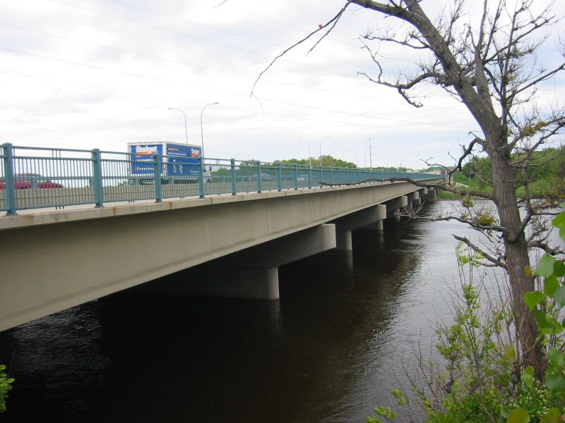
Highlights include Richard P. Braun Bridge, Banfill Tavern and Four Seasons Curling Club.
July is the warmest month, with average highs of 83°F; January lows average 7°F.
Weather in Spring Lake Park
Forecast from the National Weather Service. Full forecast
About Spring Lake Park
Spring Lake Park is a city in Anoka and Ramsey counties in the state of Minnesota. The population was 7,188 at the 2020 census. The city is located mainly within Anoka County. Minnesota State Highways 47 and 65 and County Highway 10 are three of the main routes in the city.
From the Wikipedia article Spring Lake Park, Minnesota (this version), under CC BY-SA 4.0.
Things to do1
Richard P. Braun Bridge
Bridge · 2.8 mi
Highway bridge across the Mississippi River between Brooklyn Park, Minnesota and Coon Rapids, Minnesota
Museums and landmarks1
Banfill Tavern
Monument and historic site · National Register of Historic Places · 2.4 mi
Building in Fridley, Minnesota, United States
Parks, trails and playgrounds19





7 more on the map.
Restaurants and cafes43

85°C Bakery Cafe
Cafe · Coffee Shop, Chinese · 1.1 mi
301 Northtown Drive Northeast, Blaine
Mo-Su 10:00-20:00

Baba Saj Mediterranean Food
Restaurant · Arab, Grill, Mediterranean · 1.0 mi
8685 Central Avenue Northeast
Mo-Su 09:00-25:00
Chingu Korean Fried Chicken
Restaurant · Korean · 1.1 mi
301 Northtown Drive Northeast, Blaine
Mo-Su 11:00-20:00
Guang Zhou Restaurant
Restaurant · Chinese · 0.7 mi
8478 Central Avenue Northeast, Spring Lake Park
Mo-Sa 11:00-20:00
Hokkaido Ramen House
Restaurant · Ramen · 1.1 mi
301 Northtown Drive Northeast, Blaine
Mo-Sa 11:00-21:00; Su 11:00-20:00
Mashawi Halal Grill
Restaurant · Middle Eastern · 1.2 mi
8510 Springbrook Drive Northwest, Coon Rapids
Mo-Su 09:00-21:00
Pho Mai Cafe
Cafe · Bubble Tea · 1.1 mi
301 Northtown Drive Northeast, Blaine
Mo-Sa 11:00-20:30; Su 11:00-19:30
Pho Mai Express
Restaurant · Vietnamese · 1.1 mi
301 Northtown Drive Northeast, Blaine
Mo-Sa 11:00-20:30; Su 11:00-19:30
Qamaria Yemeni Coffee Co
Cafe · Arab, Coffee Shop, Tea · 1.0 mi
8685 Central Avenue Northeast
Fr-Su 08:00-01:00; Mo-Th 08:00-23:00
Sidewalk Steak
Restaurant · Steak House, Taiwanese · 1.1 mi
301 Northtown Drive Northeast, Blaine
Mo-Su 11:00-20:00
Spice & Smoke
Restaurant · Korean, Barbecue, Hotpot · 1.1 mi
301 Northtown Drive Northeast, Blaine
Mo-Fr 12:00-21:00; Sa-Su 11:30-21:00
Friday's Little Mexico Restaurant
Restaurant · Mexican · 0.9 mi
8197 University Avenue Northeast
Su 10:00-23:00, Mo-Th 10:00-22:00, Fr-Sa 10:00-02:00
31 more on the map.
Where to stay1
Churches and places of worship6
Abiding Savior Lutheran Church
Church · Lutheran · 1.4 mi
8211 Red Oak Drive, Mounds View
Shopping13
Gas and EV charging5
Schools, colleges and libraries46
Anoka-Hennepin Regn Hs Summer Prog
School · 3.7 mi
1313 Coon Rapids Blvd Nw, Coon Rapids
Athlos Leadership Academy
School · 4.7 mi
10100 Noble Parkway North, Brooklyn Park
Healthcare3
Map of Spring Lake Park
138 places. The map loads OpenStreetMap tiles when you open it.
Climate by month
Monthly table
| Month | High | Low | Rain |
|---|---|---|---|
| Jan | 24°F | 7°F | 0.6 in |
| Feb | 29°F | 11°F | 0.6 in |
| Mar | 42°F | 23°F | 1.4 in |
| Apr | 57°F | 35°F | 2.9 in |
| May | 70°F | 47°F | 4.3 in |
| Jun | 79°F | 58°F | 4.4 in |
| Jul | 83°F | 62°F | 4.2 in |
| Aug | 81°F | 60°F | 4.1 in |
| Sep | 73°F | 52°F | 3.2 in |
| Oct | 58°F | 38°F | 2.6 in |
| Nov | 42°F | 26°F | 1.5 in |
| Dec | 29°F | 13°F | 0.9 in |
U.S. Climate Normals 1991-2020 for Mpls Crystal Ap (6 mi away), NOAA NCEI.
People and cost of living
American Community Survey 5-year estimates, 2020-2024, U.S. Census Bureau. Estimates have margins of error, larger for small towns.
Disaster history
Anoka County has had 6 federal disaster declarations since 2000, most often for biologicals.
- 2020-04-07: Covid-19 Pandemic (Biological)
- 2020-03-13: Covid-19 (Biological)
- 2011-06-07: Severe Storms And Tornadoes (Severe Storm)
- 2005-09-13: Hurricane Katrina Evacuation (Hurricane)
- 2001-05-16: Severe Winter Storms, Flooding, And Tornadoes (Flood)
- 2000-10-20: Mn - Carlos Edge Fire Complex - 10/19/2000 (Fire)
OpenFEMA disaster declarations summaries.
Getting there and nearby towns
Crystal Airport (MIC) is the nearest airport with scheduled flights listed in OpenStreetMap, 6 miles away.
- Mounds View 2 mi east, about 3 min by car
- Fridley 2 mi south, about 4 min by car
- New Brighton 4 mi southeast, about 6 min by car
- Blaine 4 mi northeast, about 7 min by car
- Lexington 4 mi northeast, about 6 min by car
- Columbia Heights 5 mi south, about 7 min by car
- Brooklyn Park 5 mi west, about 8 min by car
- Brooklyn Center 5 mi southwest, about 8 min by car
- Coon Rapids 5 mi northwest, about 9 min by car
- Arden Hills 5 mi southeast, about 8 min by car
Drive times are estimates from straight-line distance, not routes.
Local news
Headlines from INDB, the NEMICO news database.
Reviews, tips and questions
Loading what members have shared...
Sources and licences
- NCES EDGE (Public domain): public schools
- NOAA NCEI U.S. Climate Normals 1991-2020 (Public domain): climate by month
- OpenFEMA (Public domain): disaster declarations
- OpenStreetMap contributors (ODbL 1.0): places, airports, map data
- U.S. Census Bureau (Public domain): population, income, housing, education, commute
- Wikidata (CC0 1.0): elevation, founding date, time zone, website, landmarks and historic places
- Wikimedia Commons (see each image): photos
- Wikipedia (CC BY-SA 4.0): overview and history text
Photo credits
- Banfill Tavern, McGhiever, CC BY-SA 3.0
- RichardPBraunBridge, Todd Murray, CC BY-SA 3.0
Page built October 30, 2026. Spotted a mistake? Tell us or suggest a place.