


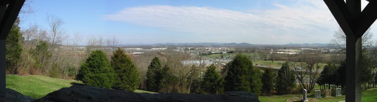
Thompson's Station, Tennessee
Thompson's Station is a town of 8,294 people in Williamson County, Tennessee.
Why visit Thompson's Station
Townapedia lists 27 museums and landmarks, 5 parks and trails, 25 places to eat, 1 place to stay and 2 attractions in and around town.
Highlights include Chambers Hill, Lookout Hill, Claiborne Kinnard House and Cleburne Jersey Farm.
July is the warmest month, with average highs of 89°F; January lows average 28°F.
Weather in Thompson's Station
Forecast from the National Weather Service. Full forecast
About Thompson's Station
Thompson's Station is a town in Williamson County, Tennessee. The population has grown from 2,194 at the 2010 Census to 7,485 in the 2020 Census. Locations in Thompson's Station listed on the U.S. National Register of Historic Places include the Jacob Critz House and the Thomas L. Critz House, Thompson's Station Bank, John Neely House, James P.
From the Wikipedia article Thompson's Station, Tennessee (this version), under CC BY-SA 4.0.
Things to do2

Museums and landmarks27

Claiborne Kinnard House
Monument and historic site · National Register of Historic Places · 4.5 mi
Historic house in Tennessee, United States

Cleburne Jersey Farm
Monument and historic site · National Register of Historic Places · 3.0 mi
Historic house in Tennessee, United States

Douglass-Reams House
Monument and historic site · National Register of Historic Places · 5.5 mi
Franklin, Tennessee, listed on the NRHP in Williamson County, Tennessee

Dr. Hezekiah Oden House
Monument and historic site · National Register of Historic Places · 5.1 mi
Historic house in Tennessee, United States

Ewell Farm
Monument and historic site · National Register of Historic Places · 4.1 mi
Farmhouse in Maury County, Tennessee, United States

Forest Hills School
Monument and historic site · National Register of Historic Places · 4.3 mi
Listed on the U.S. National Register of Historic Places

Franklin Hardeman House
Monument and historic site · National Register of Historic Places · 4.3 mi
Historic house in Tennessee, United States

H. G. W. Mayberry House
Monument and historic site · National Register of Historic Places · 5.1 mi
Historic house in Tennessee, United States

Harrison House
Monument and historic site · National Register of Historic Places · 5.1 mi
Historic house in Franklin, Tennessee, United States

Homestead Manor
Monument and historic site · National Register of Historic Places · 0.6 mi
Historic house in Tennessee, United States


Huff's Store
Monument and historic site · National Register of Historic Places · 4.1 mi
General store in Burwood, Tennessee, on the National Register of Historic Places
Jacob Critz House
Monument and historic site · National Register of Historic Places · 2.2 mi
Historic house in Tennessee, United States
15 more on the map.
Parks, trails and playgrounds5

Restaurants and cafes25

Baskin-Robbins
Ice cream · Ice Cream · 3.0 mi
2098 Wall Street, Spring Hill
Mo-Sa 05:00-22:00; Su 06:00-22:00


Starbucks
Cafe · Coffee Shop · 2.2 mi
4839 Columbia Pike, Spring Hill
Mo-Th, Su 05:30-20:30 open; Fr-Sa 05:30-19:00 open

Mojo's Tacos - Tollgate
Restaurant · Tex-Mex, Mexican, Tacos · 1.7 mi
2000 Tollgate Boulevard, Thompson's Station
Sunny China
Restaurant · Chinese · 2.5 mi
4910 Campbell Station Parkway, Spring Hill
Su-Mo, We-Th 10:30-21:00; Fr-Sa 10:30-22:00
Don Arturo's Mexican Grill
Restaurant · Mexican · 2.6 mi
4910 Main St, Spring Hill
Su-Th 11:00-21:00; Fr-Sa 11:00-22:00

13 more on the map.
History
The first settlers arrived in what is now Thompson's Station in the late 18th century. The community was originally known as "White House," but changed its name to "Littlebury" in 1836. After the arrival of the railroad in 1855, Dr. Elijah Thompson donated land for a town and train station, and the community was renamed for him.
On March 5, 1863, during the Civil War, the Battle of Thompson's Station was fought, with Confederate forces led by General Earl Van Dorn defeating Union forces under Colonel John Coburn.
From the History section of Thompson's Station, Tennessee on Wikipedia, under CC BY-SA 4.0.
Where to stay1
Churches and places of worship34
Grace Episcopal Church
Church · National Register of Historic Places · 4.3 mi
Spring Hill Presbyterian Church
Church · National Register of Historic Places · 4.6 mi
St. Mark United Primitive Baptist Church
Church · National Register of Historic Places · 4.5 mi
Rolling Hills Church of Christ
Church · Church Of Christ · 2.6 mi
2001 Wall Street, Spring Hill
Thompson Station Church of Christ
Church · Church Of Christ · 1.3 mi
4721 Columbia Pike, Thompson"s Station
Catholic Church of the Nativity
Church · 3.5 mi
2793 Buckner Lane, Thompson's Station
Connection Hill Primitive Baptist Church
Church · 2.1 mi
2732 Thompsons Station Road East, Thompson's Station
Cowles Chapel United Methodist Church
Church · 3.3 mi
2891 Critz Lane, Thompson's Station
Shopping5
Gas and EV charging7
Schools, colleges and libraries21
Stegmanns School of Performing Arts
School · 2.4 mi
2001 Campbell Station Parkway, Suite 4, Spring Hill
Healthcare2
Map of Thompson's Station
129 places. The map loads OpenStreetMap tiles when you open it.
Climate by month
Monthly table
| Month | High | Low | Rain | Snow |
|---|---|---|---|---|
| Jan | 48°F | 28°F | 4.6 in | 1.2 in |
| Feb | 51°F | 32°F | 5.2 in | 1.5 in |
| Mar | 61°F | 39°F | 5.0 in | 0.5 in |
| Apr | 71°F | 47°F | 5.3 in | 0.0 in |
| May | 79°F | 57°F | 5.1 in | 0.0 in |
| Jun | 87°F | 66°F | 4.6 in | 0.0 in |
| Jul | 89°F | 69°F | 4.6 in | 0.0 in |
| Aug | 89°F | 69°F | 3.6 in | 0.0 in |
| Sep | 84°F | 62°F | 4.1 in | 0.0 in |
| Oct | 73°F | 49°F | 3.8 in | 0.0 in |
| Nov | 61°F | 38°F | 4.2 in | 0.0 in |
| Dec | 51°F | 32°F | 5.8 in | 0.3 in |
U.S. Climate Normals 1991-2020 for Thompson Stn (4 mi away), NOAA NCEI.
People and cost of living
American Community Survey 5-year estimates, 2020-2024, U.S. Census Bureau. Estimates have margins of error, larger for small towns.
Disaster history
Williamson County has had 10 federal disaster declarations since 2000, most often for severe storms.
- 2026-02-06: Severe Winter Storm (Winter Storm)
- 2026-01-24: Severe Winter Storm (Winter Storm)
- 2025-04-02: Severe Storms, Straight-Line Winds, Tornadoes, And Flooding (Severe Storm)
- 2021-05-08: Severe Storms, Tornadoes, And Flooding (Tornado)
- 2020-04-02: Covid-19 Pandemic (Biological)
- 2020-03-13: Covid-19 (Biological)
OpenFEMA disaster declarations summaries.
Getting there and nearby towns
Maury County Airport (MRC) is the nearest airport with scheduled flights listed in OpenStreetMap, 24 miles away.
- Spring Hill 5 mi south, about 8 min by car
- Franklin 8 mi northeast, about 12 min by car
- Brentwood 15 mi northeast, about 24 min by car
- Columbia 15 mi southwest, about 24 min by car
- Nolensville 17 mi northeast, about 27 min by car
- Fairview 17 mi northwest, about 27 min by car
- Chapel Hill 17 mi southeast, about 28 min by car
- Forest Hills 18 mi north, about 29 min by car
- Oak Hill 19 mi north, about 30 min by car
- Nashville-Davidson 26 mi north, about 42 min by car
Drive times are estimates from straight-line distance, not routes.
Local news
Headlines from INDB, the NEMICO news database.
Reviews, tips and questions
Loading what members have shared...
Sources and licences
- NCES EDGE (Public domain): public schools
- NOAA NCEI U.S. Climate Normals 1991-2020 (Public domain): climate by month
- OpenFEMA (Public domain): disaster declarations
- OpenStreetMap contributors (ODbL 1.0): places, airports, map data
- U.S. Census Bureau (Public domain): population, income, housing, education, commute
- Wikidata (CC0 1.0): elevation, founding date, time zone, website, landmarks and historic places
- Wikimedia Commons (see each image): photos
- Wikipedia (CC BY-SA 4.0): overview and history text
Photo credits
- Thompsons station town hall tennessee 2010, Ichabod, CC BY-SA 3.0
- Homestead Manor 2, rossograph, CC BY-SA 4.0
- Cheairs Mansion Spring Hill TN, Hal Jespersen at en.wikipedia, Public domain
- Thompson Station Bank, Joe Elliott, CC BY-SA 3.0
- John Pope House (Burwood, Tennessee), Skye Marthaler, CC BY-SA 3.0
- Winstead Hill Franklin TN, J. Williams, Public domain
- Douglas-Reams House-Franklin, TN, rossograph, CC BY-SA 4.0
- Grace Episcopal Church Spring Hill, TN, Skye Marthaler, CC BY-SA 3.0
- HARRISON HOUSE, JERRYE & ROY KLOTZ MD, CC BY-SA 3.0
- Spring Hill Presbyterian Church, Skye Marthaler, CC BY-SA 3.0
- White Hall, Skye Marthaler, CC BY-SA 3.0
- St. Mark United Primitive Baptist Church, Skye Marthaler, CC BY-SA 3.0
- Franklin Hardeman House, rossograph, CC BY-SA 4.0
- Huff's Store, Skye Marthaler, CC BY-SA 3.0
- Thomas L. Critz House, rossograph, CC BY-SA 4.0
- Dr. Hezekiah Oden House-Franklin, TN, rossograph, CC BY-SA 4.0
- Spencer Buford House *, Wptitus, CC BY-SA 3.0
- James P. Johnson, Mthunter58, CC BY-SA 4.0
- Clairborne Kinnard House, Skye Marthaler, CC BY-SA 3.0
- H.G.W. Mayberry House, Skye Marthaler, CC BY-SA 3.0
- Ewell Farm Spring Hill TN, Hal Jespersen at en.wikipedia, Public domain
- Forest Hills School, Skye Marthaler, CC BY-SA 3.0
- Ritter-Morton House, Skye Marthaler, CC BY-SA 3.0


Page built October 30, 2026. Spotted a mistake? Tell us or suggest a place.