
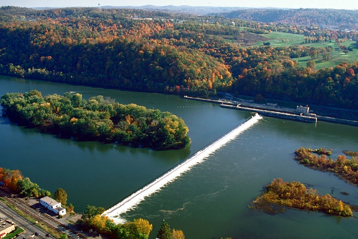


Verona, Pennsylvania
Verona is a borough of 2,524 people in Allegheny County, Pennsylvania, founded in 1769.
Why visit Verona
Townapedia lists 8 museums and landmarks, 23 parks and trails, 23 places to eat, 1 place to stay and 4 attractions in and around town.
Highlights include Bessemer & Lake Erie Railroad Bridge, Jonathon Hulton Bridge, Allegheny River Lock and Dam No. 3 and Dr. Thomas R. Kerr House and Office.
July is the warmest month, with average highs of 83°F; January lows average 19°F.
Weather in Verona
Forecast from the National Weather Service. Full forecast
About Verona
Verona is a borough in Allegheny County, Pennsylvania, United States. It is 13 miles (21 km) northeast of downtown Pittsburgh, along the left bank of the Allegheny River. As of the 2020 census, the borough had a population of 2,492.
From the Wikipedia article Verona, Pennsylvania (this version), under CC BY-SA 4.0.
Things to do4

Bessemer & Lake Erie Railroad Bridge
Bridge · 2.5 mi
Bridge over the Allegheny River in Pennsylvania

Jonathon Hulton Bridge
Bridge · 1.6 mi
Bridge over the Allegheny River in Pennsylvania


Museums and landmarks8
Allegheny River Lock and Dam No. 3
Monument and historic site · National Register of Historic Places · 2.7 mi
Place in Pennsylvania listed on National Register of Historic Places

Dr. Thomas R. Kerr House and Office
Monument and historic site · National Register of Historic Places · 0.8 mi
Oakmont, Pennsylvania, NRHP-listed
Longue Vue Club and Golf Course
Monument and historic site · National Register of Historic Places · 1.9 mi
Golf course in Verona, Pennsylvania
Oakmont Country Club
Monument and historic site · National Register of Historic Places · 1.6 mi
Country club in the eastern United States
Sauer Buildings Historic District
Monument and historic site · National Register of Historic Places · 3.3 mi
Historic district in Pennsylvania, United States
Lehner Grain-and-Cider Mill and House
Monument and historic site · National Register of Historic Places

Parks, trails and playgrounds23





11 more on the map.
Restaurants and cafes23

Leone's Pizza
Restaurant · Pizza, Italian · 0.9 mi
608 Allegheny River Boulevard, Oakmont
Mo-Sa 11:00-22:00, Su 11:00-19:00



Off the Rails Barbecue & Drafthouse
Restaurant · Barbecue
549 Allegheny River Boulevard, Verona

11 more on the map.
History
Verona was named by creating a portmanteau of the names of the Verner and Iona railroad stops along the Allegheny Valley Railroad. James Verner was the town's founder.
From the History section of Verona, Pennsylvania on Wikipedia, under CC BY-SA 4.0.
Where to stay1
Churches and places of worship12
Shopping8
Gas and EV charging3
Schools, colleges and libraries50
Healthcare3
Map of Verona
135 places. The map loads OpenStreetMap tiles when you open it.
Climate by month
Monthly table
| Month | High | Low | Rain |
|---|---|---|---|
| Jan | 36°F | 19°F | 3.4 in |
| Feb | 40°F | 21°F | 2.9 in |
| Mar | 49°F | 28°F | 3.7 in |
| Apr | 62°F | 38°F | 3.7 in |
| May | 72°F | 48°F | 3.9 in |
| Jun | 79°F | 58°F | 4.5 in |
| Jul | 83°F | 62°F | 4.5 in |
| Aug | 82°F | 60°F | 3.6 in |
| Sep | 76°F | 54°F | 4.2 in |
| Oct | 64°F | 43°F | 3.3 in |
| Nov | 51°F | 32°F | 3.3 in |
| Dec | 42°F | 26°F | 3.7 in |
U.S. Climate Normals 1991-2020 for Acmetonia Lock 3 (3 mi away), NOAA NCEI.
People and cost of living
American Community Survey 5-year estimates, 2020-2024, U.S. Census Bureau. Estimates have margins of error, larger for small towns.
Disaster history
Allegheny County has had 8 federal disaster declarations since 2000, most often for hurricanes.
- 2020-03-30: Covid-19 Pandemic (Biological)
- 2020-03-13: Covid-19 (Biological)
- 2013-10-01: Severe Storms, Tornadoes, And Flooding (Severe Storm)
- 2012-10-29: Hurricane Sandy (Hurricane)
- 2010-04-16: Severe Winter Storms And Snowstorms (Snowstorm)
- 2005-09-10: Hurricane Katrina (Hurricane)
OpenFEMA disaster declarations summaries.
Getting there and nearby towns
Allegheny County Airport (AGC) is the nearest airport with scheduled flights listed in OpenStreetMap, 11 miles away.
- Oakmont 1 mi north, about 2 min by car
- Blawnox 1 mi southwest, about 2 min by car
- Fox Chapel 3 mi northwest, about 5 min by car
- Aspinwall 3 mi west, about 5 min by car
- Cheswick 3 mi northeast, about 5 min by car
- Springdale 4 mi northeast, about 6 min by car
- Sharpsburg 4 mi west, about 7 min by car
- Wilkinsburg 5 mi south, about 7 min by car
- Plum 5 mi east, about 8 min by car
- Churchill 5 mi south, about 7 min by car
Drive times are estimates from straight-line distance, not routes.
Local news
Headlines from INDB, the NEMICO news database.
Reviews, tips and questions
Loading what members have shared...
Sources and licences
- NCES EDGE (Public domain): public schools
- NOAA NCEI U.S. Climate Normals 1991-2020 (Public domain): climate by month
- OpenFEMA (Public domain): disaster declarations
- OpenStreetMap contributors (ODbL 1.0): places, airports, map data
- U.S. Census Bureau (Public domain): population, income, housing, education, commute
- Wikidata (CC0 1.0): elevation, founding date, time zone, website, landmarks and historic places
- Wikimedia Commons (see each image): photos
- Wikipedia (CC BY-SA 4.0): overview and history text
Photo credits
- Allegheny Islands State Park, C.W. Bill Young Lock and Dam, U.S. Army Corps of Engineers, Public domain
- Hulton Bridge - 20200706, Derek Kalinosky, CC BY-SA 4.0
- B&lerr, Jet Lowe, National Park Service, Public domain
- Abandoned, Jeremy Levin, CC BY 3.0
- Abandoned, Jeremy Levin, CC BY 3.0
- The Oaks Theater, James Watt, CC0
- Lachnum virgineum 305516769, Julie Travaglini, CC BY 4.0
- Conocybe apala 305392991, Julie Travaglini, CC BY 4.0
- Dr. Thomas R. Kerr Memorial Museum , Oakmont, PA, Marilynmccoy1, CC BY-SA 4.0
- St. Thomas Memorial Church - Oakmont, Pennsylvania 03, Farragutful, CC BY-SA 4.0
- St. Thomas Memorial Church - Oakmont, Pennsylvania 01, Farragutful, CC BY-SA 4.0
- St. Thomas Memorial Church - Oakmont, Pennsylvania 04, Farragutful, CC BY-SA 4.0
- St. Thomas Memorial Church - Oakmont, Pennsylvania 02, Farragutful, CC BY-SA 4.0
- Oakmont UMC, Farragutful, CC BY-SA 4.0
- St. Irenaeus Catholic Church - Oakmont, Pennsylvania, Farragutful, CC BY-SA 4.0
- Fountain Street Rooflines (Blawnox, PA) (1519780542), takomabibelot, CC BY 2.0
- Old factory in Blawnox, takomabibelot, CC BY 2.0
- Trametes trogii 14470803, Garrett Taylor, CC BY 4.0
- Trametes trogii 14394517, Garrett Taylor, CC BY 4.0
- Steccherinum ochraceum 14394510, Garrett Taylor, CC BY 4.0
- Steccherinum ochraceum 14394506, Garrett Taylor, CC BY 4.0
- Loweomyces fractipes 305513387, Julie Travaglini, CC BY 4.0
- Loweomyces fractipes 305513440, Julie Travaglini, CC BY 4.0
- Exidia glandulosa 83681836, Ron Burkert, CC BY 4.0
- Steatoda triangulosa egg sacs, rpburkert, CC BY 4.0
- Nate McLouth (2876295002), John Marino from Pittsburgh, The fine US of A, CC BY 2.0
- Polistes parametricus 23609286, Ron Burkert, CC BY 4.0
- Jonathon Hulton Bridge, Jim Kuhn, CC BY 2.0
- American Bittercress, Ron Burkert, CC BY 4.0
- Hulton Bridge from the Oakmont approach, Doug Kerr from Albany, NY, United States, CC BY-SA 2.0
- Allodus podophylli 272700233, Julie Travaglini, CC BY 4.0
- Tympanis alnea 272701599, Julie Travaglini, CC BY 4.0
- Jonathon Hulton Bridge (3014915789), Doug Kerr from Albany, NY, United States, CC BY-SA 2.0
- Jonathon Hulton Bridge (3014915861), Doug Kerr from Albany, NY, United States, CC BY-SA 2.0
- Hulton Bridge, The original uploader was Cngodles at English Wikipedia ., Public domain


Page built October 30, 2026. Spotted a mistake? Tell us or suggest a place.