


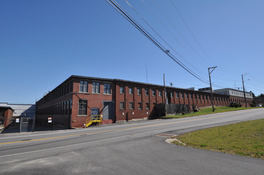


Westbrook, Maine
Westbrook is a city of 20,775 people in Cumberland County, Maine, founded in 1814.
Why visit Westbrook
Townapedia lists 53 museums and landmarks, 116 parks and trails, 79 places to eat, 5 places to stay and 18 attractions in and around town.
Highlights include Institute for Doctoral Studies in the Visual Arts, Martin's Point Bridge, Westbrook College Historic District and Academy Building.
July is the warmest month, with average highs of 80°F; January lows average 16°F, and about 69 inches of snow fall in a normal year.
Weather in Westbrook
Forecast from the National Weather Service. Full forecast
About Westbrook
Westbrook is a city in Cumberland County, Maine, United States and a suburb of Portland. The population was 20,400 at the 2020 census, making it the fastest-growing city in Maine between 2010 and 2020. It is part of the Portland–South Portland–Biddeford, Maine metropolitan statistical area.
From the Wikipedia article Westbrook, Maine (this version), under CC BY-SA 4.0.
Things to do18

Institute for Doctoral Studies in the Visual Arts
School · 5.5 mi
Education organization in Portland, United States




6 more on the map.
Museums and landmarks53

Westbrook College Historic District
Monument and historic site · National Register of Historic Places · 3.3 mi
Historic district in Maine, United States

Academy Building
Monument and historic site · National Register of Historic Places · 5.0 mi
Building in Maine, United States

Adam P. Leighton House
Monument and historic site · National Register of Historic Places · 5.5 mi
House in Portland, Maine

Baxter House
Monument and historic site · National Register of Historic Places · 5.0 mi
Historic house in Maine, United States

Cumberland and Oxford Canal
Monument and historic site · National Register of Historic Places · 4.0 mi
Canal in Cumberland County, Maine, United States of America
Cumberland Mills Historic District
Monument and historic site · National Register of Historic Places · 1.8 mi

Elisha Purington House
Monument and historic site · National Register of Historic Places · 3.9 mi
Historic house in Maine, United States

Evergreen Cemetery
Monument and historic site · National Register of Historic Places · 3.1 mi
Cemetery in Portland, Maine

Falmouth House
Monument and historic site · National Register of Historic Places · 5.1 mi
Historic house in Maine, United States

Gorham Campus Historic District
Monument and historic site · National Register of Historic Places · 5.0 mi
Historic district in Gorham, Maine

Gorham Historic District
Monument and historic site · National Register of Historic Places · 5.0 mi
Historic district in Gorham, Maine

Hall's Tavern
Monument and historic site · National Register of Historic Places · 5.4 mi
Listed on the NRHP in Cumberland County, Maine
41 more on the map.
Parks, trails and playgrounds116


Deering Oaks
Park · National Register of Historic Places · 5.3 mi
Park in Maine, United States of America

Fore River Sanctuary
Park · 3.3 mi
Park in Portland, Cumberland County, United States of America
Baxter Woods
Park · 3.7 mi
Park in Maine, United States of America, United States of America



Riverton Trolley Park
Park · 1.5 mi
822 Riverside Street, Portland
Mo-Su 06:30-22:00
104 more on the map.
Restaurants and cafes79

Blazes Burgers
Restaurant · Burger · 2.3 mi
861 Main Street, Westbrook
Tu,We,Th,Su 11:00-18:00; Fr-Sa 11:00-19:00
Bogusha's Polish Restaurant & Deli
Restaurant · Polish · 3.3 mi
825 Stevens Avenue, Portland
Mo-Sa 10:30-17:00
Casa Novello
Restaurant · Italian · 2.1 mi
694 Main Street, Westbrook
Mo-Th 16:00-20:30; Fr-Sa 16:00-21:30; Su 15:30-20:00
Falafel Time
Restaurant · Middle Eastern · 3.5 mi
1053 Forest Avenue, Portland
Mo 12:00-20:00; We-Su 12:00-20:00
Ginza Town
Restaurant · Japanese · 3.5 mi
1053 Forest Avenue, Portland
Mo-Th 11:00-21:30; Fr,Sa 11:00-22:00; Su 16:00-21:00
Portland House of Pizza
Restaurant · Pizza, Italian, Pasta, Burger, Sandwich · 3.3 mi
1359 Washington Avenue, Portland
Mo-Su 11:00-21:00
Portland Pie Company
Restaurant · Pizza · 2.3 mi
869 Main Street, Westbrook
Mo-Th,Su 11:00-22:00; Fr-Sa 10:00-23:00


Frog & Turtle
Bar and pub · 2.2 mi
3 Bridge Street, Westbrook
Tu-Th 16:00-21:00; Fr-Sa 16:00-23:00; Su 09:00-13:00
67 more on the map.
History
Originally known as Saccarappa after Saccarappa Falls on the Presumpscot River, it was a part of Falmouth, Maine until February 14, 1814, when it was set off and incorporated as Stroudwater. It soon changed its name to Westbrook after Colonel Thomas Westbrook, a commander during Father Rale's War and King's mast agent who was an early settler and mill operator. In 1871, the town of Westbrook amicably split into two municipalities; present-day Westbrook and Deering, which was annexed by Portland in 1898. In 1891, Westbrook was incorporated as a city.
Saccarappa Falls and Congin Falls provided water power for early mills (watermills) within the city. In 1829, a sawmill was built at the former which made the mill town noted for its lumber. Other industries followed, manufacturing grain bags, machinery and water wheels, carriage and harness, boots, shoes and moccasins, tinware, leather board, bricks, wooden boxes, box shooks (slats and boards nailed or stapled together to make boxes), meal, and flour. The Portland Manufacturing Company built a cotton textile mill at Saccarappa Falls for making "sheetings, stripes and ducks." A paper mill was built at Cumberland Mills, once an Indian planting ground known as Ammoncongin. By 1859, it produced 1,000 tons of paper annually. In 1867, the factory's name changed to the S. D. Warren Paper Mill.
From the History section of Westbrook, Maine on Wikipedia, under CC BY-SA 4.0.
Where to stay5
Churches and places of worship30
Saint Edmund Catholic Church
Church · Roman Catholic · 1.1 mi
355 Bridgton Road, Westbrook
Shopping15
Gas and EV charging13
Schools, colleges and libraries43
Walker Memorial Library
Library · National Register of Historic Places · 2.3 mi
800 Main Street, Westbrook
Baxter Academy For Tech & Sciences
School · 5.6 mi
185 Lancaster Street, Portland
Healthcare5
Map of Westbrook
250 places. The map loads OpenStreetMap tiles when you open it.
Climate by month
Monthly table
| Month | High | Low | Rain | Snow |
|---|---|---|---|---|
| Jan | 32°F | 16°F | 3.5 in | 18.6 in |
| Feb | 35°F | 17°F | 3.5 in | 16.6 in |
| Mar | 42°F | 26°F | 4.1 in | 13.6 in |
| Apr | 54°F | 35°F | 4.4 in | 2.8 in |
| May | 64°F | 46°F | 3.7 in | 0.0 in |
| Jun | 74°F | 55°F | 4.2 in | 0.0 in |
| Jul | 80°F | 61°F | 3.4 in | 0.0 in |
| Aug | 79°F | 60°F | 3.6 in | 0.0 in |
| Sep | 71°F | 52°F | 3.8 in | 0.0 in |
| Oct | 60°F | 41°F | 5.2 in | 0.2 in |
| Nov | 48°F | 32°F | 4.2 in | 2.3 in |
| Dec | 38°F | 22°F | 4.5 in | 14.6 in |
U.S. Climate Normals 1991-2020 for Portland Intl Jetport Hcn 72606 (5 mi away), NOAA NCEI.
People and cost of living
American Community Survey 5-year estimates, 2020-2024, U.S. Census Bureau. Estimates have margins of error, larger for small towns.
Disaster history
Cumberland County has had 21 federal disaster declarations since 2000, most often for severe storms.
- 2024-05-24: Severe Winter Storm (Winter Storm)
- 2024-03-20: Severe Storms And Flooding (Severe Storm)
- 2023-09-14: Hurricane Lee (Hurricane)
- 2020-04-04: Covid-19 Pandemic (Biological)
- 2020-03-13: Covid-19 (Biological)
- 2018-01-02: Severe Storm And Flooding (Severe Storm)
OpenFEMA disaster declarations summaries.
Getting there and nearby towns
Portland International Jetport (PWM) is the nearest airport with scheduled flights listed in OpenStreetMap, 5 miles away.
- Gorham 4 mi west, about 7 min by car
- South Portland 6 mi southeast, about 10 min by car
- Portland 10 mi southeast, about 16 min by car
- Saco 13 mi south, about 21 min by car
- Biddeford 19 mi south, about 30 min by car
- Brunswick 24 mi northeast, about 38 min by car
- Auburn 27 mi north, about 43 min by car
- Lewiston 28 mi north, about 45 min by car
- Sanford 28 mi southwest, about 45 min by car
- Augusta 53 mi northeast, about 1 h 30 min by car
Drive times are estimates from straight-line distance, not routes.
Local news
Headlines from INDB, the NEMICO news database.
Reviews, tips and questions
Loading what members have shared...
Sources and licences
- NCES EDGE (Public domain): public schools
- NOAA NCEI U.S. Climate Normals 1991-2020 (Public domain): climate by month
- OpenFEMA (Public domain): disaster declarations
- OpenStreetMap contributors (ODbL 1.0): places, airports, map data
- U.S. Census Bureau (Public domain): population, income, housing, education, commute
- Wikidata (CC0 1.0): elevation, founding date, time zone, website, landmarks and historic places
- Wikimedia Commons (see each image): photos
- Wikipedia (CC BY-SA 4.0): overview and history text
Photo credits
- WestbrookME CumberlandMills 3, Magicpiano, CC BY-SA 3.0
- WestbrookME CumberlandMills 1, Magicpiano, CC BY-SA 3.0
- WestbrookME CumberlandMills 2, Magicpiano, CC BY-SA 3.0
- WestbrookME NathanHarrisHouse, Magicpiano, CC BY-SA 3.0
- WestbrookME StHyacinthSchool, Magicpiano, CC BY-SA 3.0
- Civil War Memorial in Riverbank Park, Westbrook, Maine, Kenneth C. Zirkel, CC BY-SA 4.0
- Civil War Memorial, Riverbank Park, Westbrook, Maine, Kenneth C. Zirkel, CC BY-SA 4.0
- Wv Westbrook banner, Kenneth C. Zirkel, CC BY-SA 4.0
- Old Westbrook High School, Westbrook, Maine, Kenneth C. Zirkel, CC BY-SA 4.0
- Old Westbrook High School, Westbrook ME, John Phelan, CC BY-SA 3.0
- Walker Memorial Library, Westbrook, Maine detail, Kenneth C. Zirkel, CC BY-SA 4.0
- Walker Memorial Library, Westbrook ME, John Phelan, CC BY-SA 3.0
- 36 Monroe Avenue, Westbrook ME, John Phelan, CC BY-SA 3.0
- UNE Ludcke Auditorium, BMRR, CC BY-SA 3.0
- Marine Hospital - Portland, Maine, Farragutful, CC BY-SA 4.0
- 261 Western Promenade, Portland ME, John Phelan, CC BY-SA 3.0
- John B. Russwurm House, Farragutful, CC BY-SA 4.0
- Maine Eye and Ear Infirmary, Portland ME, John Phelan, CC BY-SA 3.0
- Corthell Hall, University of Southern Maine, Gorham ME, John Phelan, CC BY-SA 3.0
- DeeringOaksDeeringAvenue, Unknown author, Public domain
- FalmouthME HallsTavern, Magicpiano, CC BY-SA 4.0
- School Street, Gorham ME, John Phelan, CC BY-SA 3.0
- PortlandME TateHouse 02, User:Magicpiano, CC BY-SA 4.0
- GorhamME IsaacDyerEstate, Magicpiano, CC BY-SA 3.0
- FalmouthME PlummerMotzSchool2, Magicpiano, CC BY-SA 4.0
- Baxter House, Gorham ME, John Phelan, CC BY-SA 3.0
- FalmouthME ElishaPuringtonHouse, Magicpiano, CC BY-SA 4.0
- Current Art Gallery at the University of Southern Maine, Patrick Higgins, CC BY-SA 3.0
- FalmouthME FalmouthHouse, Magicpiano, CC BY-SA 4.0
- Sparrow House - Portland, Maine, Farragutful, CC BY-SA 4.0
- GorhamME SouthStreetHD 4, Magicpiano, CC BY-SA 3.0
- Nathan Clifford Residences, Farragutful, CC BY-SA 4.0
- PortlandME StroudwaterHD, Magicpiano, CC BY-SA 3.0
- Warren Block in 2017, Westbrook, Maine, Kenneth C. Zirkel, CC BY-SA 4.0
- Leonard Bond Chapman House, Farragutful, CC BY-SA 4.0
- GorhamME McLellanHouse, Magicpiano, CC BY-SA 3.0
- Maine Central Railroad General Office Building, Portland, ME, Unknown author Unknown author, Public domain
- University of Southern Maine Academy Building, User:Nickline4, CC0
- EvergreenCemeteryPortland, Thomas.macmillan, CC BY 3.0
- Turdus iliacus, Portland, Maine, USA 111516129, Tova, CC BY-SA 4.0


Page built October 30, 2026. Spotted a mistake? Tell us or suggest a place.