
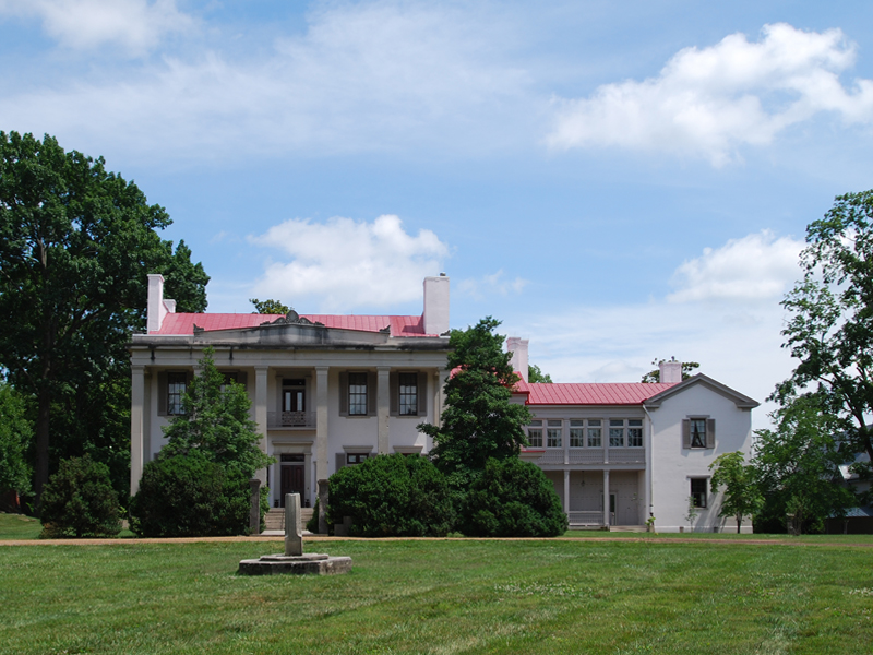


Belle Meade, Tennessee
Belle Meade is a city of 2,708 people in Davidson County, Tennessee.
Why visit Belle Meade
Townapedia lists 25 museums and landmarks, 7 parks and trails, 9 places to eat and 1 attraction in and around town.
Highlights include Darkhorse Theater, Belle Meade Plantation, Belle Meade Apartments and Warner Parks.
July is the warmest month, with average highs of 87°F; January lows average 28°F.
Weather in Belle Meade
Forecast from the National Weather Service. Full forecast
About Belle Meade
Belle Meade is a suburban city on the west side of Nashville, Tennessee in Davidson County. Its total land area is 3.1 square miles (8.0 km2), and its population was 2,901 at the 2020 census. The city functions as an independent municipality with its own regulations, city hall, and police department, distinct from the Metropolitan Nashville Government (Metro). Residents pay property taxes for these services, and also pay taxes to Metro for fire protection, ambulance service, and other municipal functions.
From the Wikipedia article Belle Meade, Tennessee (this version), under CC BY-SA 4.0.
Things to do1

Museums and landmarks25

Belle Meade Plantation
Monument and historic site · National Register of Historic Places · 0.6 mi
Human settlement in United States of America
5025 Harding Pike, Nashville

Belle Meade Apartments
Monument and historic site · National Register of Historic Places
Historic building in Belle Meade, Tennessee

Cheekwood Botanical Garden and Museum of Art
Museum · National Register of Historic Places · 1.3 mi
American nonprofit organization
Dr. Cobb Pilcher House
Monument and historic site · National Register of Historic Places · 2.0 mi
Historic house in Tennessee, United States

Dr. Richard and Mrs. Margaret Martin House
Monument and historic site · National Register of Historic Places · 2.4 mi
Building in Tennessee, United States

Dubuisson-Neuhoff House
Monument and historic site · National Register of Historic Places · 1.9 mi
Building in Tennessee, United States

Gladstone Apartments
Monument and historic site · National Register of Historic Places · 2.6 mi
Building in Tennessee, United States

Glen Oak
Monument and historic site · National Register of Historic Places · 3.6 mi
Building in Tennessee, United States
Guildford Dudley, Sr. and Anne Dallas House
Monument and historic site · National Register of Historic Places · 1.6 mi
Single-family detached home in Forest Hills, United States of America

J.B. Daniel House
Monument and historic site · National Register of Historic Places · 2.9 mi
Mansion in Nashville, Tennessee
Longleat
Monument and historic site · National Register of Historic Places · 1.8 mi
Historic house in Nashville, Tennessee

Mrs. Edward B. Craig House
Monument and historic site · National Register of Historic Places · 2.0 mi
Mansion in Forest Hills, Tennessee
13 more on the map.
Parks, trails and playgrounds7

Warner Parks
Park · National Register of Historic Places · 3.2 mi
Parks located outside downtown Nashville, Tennessee




Restaurants and cafes9

Whitt's Barbecue
Restaurant · Barbecue · 0.8 mi
Regional take-out and drive-through barbecue chain with pulled pork, turkey, ribs, and hot wings.
5310 Highway 70 South, Nashville
Mo-Sa 08:30-20:00

Coco's West Italian Restaurant
Restaurant · Italian · 0.9 mi
5406 Harding Pike, Nashville

History
Belle Meade Plantation— The Belle Meade Plantation once encompassed a vast estate known internationally for its thoroughbred horse breeding. It was founded by planter John Harding and was passed down to his son, William Giles Harding. Before the Civil War, the younger Harding more than doubled the property and in 1853 built a Greek revival mansion, with the labor of the 136 enslaved African people. At its height, the property grew to an eight-square-mile estate nationally renowned for its thoroughbred horse breeding,
The Civil War— In the Civil War, when the Union Army took control of Nashville, the mansion was pillaged and looted by soldiers who spent weeks quartered there; the owner was imprisoned. In the aftermath, the plantation recovered, but with greatly reduced capacity. Roughly half (72) enslaved persons returned as paid employees after emancipation and lived in their own homes nearby. After a financial downturn in 1893 and later the death of the owner and his heir, the estate was dismantled and sold in parcels in 1906. The property was divided into tracts that eventually would include the city of Belle Meade, Cheekwood Botanical Gardens, Percy Warner Park, Belle Meade Country Club, and various upscale residential areas.
From the History section of Belle Meade, Tennessee on Wikipedia, under CC BY-SA 4.0.
Churches and places of worship13
Hillsboro Church of Christ
Church · Church Of Christ · 1.9 mi
5800 Hillsboro Pike, Nashville
Shopping2
Gas and EV charging2
Schools, colleges and libraries52
Healthcare1
Map of Belle Meade
112 places. The map loads OpenStreetMap tiles when you open it.
Climate by month
Monthly table
| Month | High | Low | Rain |
|---|---|---|---|
| Jan | 48°F | 28°F | 5.2 in |
| Feb | 52°F | 31°F | 5.0 in |
| Mar | 61°F | 38°F | 4.7 in |
| Apr | 71°F | 47°F | 4.7 in |
| May | 77°F | 56°F | 5.5 in |
| Jun | 83°F | 64°F | 4.5 in |
| Jul | 87°F | 68°F | 4.7 in |
| Aug | 87°F | 67°F | 3.5 in |
| Sep | 82°F | 60°F | 4.2 in |
| Oct | 71°F | 48°F | 3.9 in |
| Nov | 60°F | 37°F | 3.5 in |
| Dec | 51°F | 31°F | 4.3 in |
U.S. Climate Normals 1991-2020 for Warner Park (4 mi away), NOAA NCEI.
People and cost of living
American Community Survey 5-year estimates, 2020-2024, U.S. Census Bureau. Estimates have margins of error, larger for small towns.
Disaster history
Davidson County has had 21 federal disaster declarations since 2000, most often for severe storms.
- 2026-02-06: Severe Winter Storm (Winter Storm)
- 2026-01-24: Severe Winter Storm (Winter Storm)
- 2025-06-19: Severe Storms, Straight-Line Winds, Tornadoes, And Flooding (Severe Storm)
- 2025-04-02: Severe Storms, Straight-Line Winds, Tornadoes, And Flooding (Severe Storm)
- 2023-12-13: Severe Storms And Tornadoes (Severe Storm)
- 2023-05-17: Severe Storms, Straight-Line Winds, And Tornado (Severe Storm)
OpenFEMA disaster declarations summaries.
Getting there and nearby towns
Nashville International Airport (BNA) is the nearest airport with scheduled flights listed in OpenStreetMap, 10 miles away.
- Nashville-Davidson 6 mi northeast, about 10 min by car
- Brentwood 9 mi southeast, about 14 min by car
- Franklin 13 mi south, about 21 min by car
- Nolensville 14 mi southeast, about 23 min by car
- Ashland City 15 mi northwest, about 24 min by car
- La Vergne 17 mi east, about 28 min by car
- Fairview 17 mi southwest, about 28 min by car
- Goodlettsville 18 mi northeast, about 29 min by car
- Hendersonville 20 mi northeast, about 32 min by car
- Smyrna 21 mi southeast, about 33 min by car
Drive times are estimates from straight-line distance, not routes.
Local news
Headlines from INDB, the NEMICO news database.
Reviews, tips and questions
Loading what members have shared...
Sources and licences
- NCES EDGE (Public domain): public schools
- NOAA NCEI U.S. Climate Normals 1991-2020 (Public domain): climate by month
- OpenFEMA (Public domain): disaster declarations
- OpenStreetMap contributors (ODbL 1.0): places, airports, map data
- U.S. Census Bureau (Public domain): population, income, housing, education, commute
- Wikidata (CC0 1.0): elevation, founding date, time zone, website, landmarks and historic places
- Wikimedia Commons (see each image): photos
- Wikipedia (CC BY-SA 4.0): overview and history text
Photo credits
- Belle Meade Plantation, Colin1769, CC BY-SA 3.0
- Richland Hall, Skye Marthaler, CC BY-SA 3.0
- Woodlawn (Nashville, Tennessee), Skye Marthaler, CC BY-SA 3.0
- Glen Oak, Nashville, Nyttend, Public domain
- WTN PeepHoles 082, Unknown author, Public domain
- Central Avenue in Richland-West End, Nyttend, Public domain
- J.B. Daniel House, Women's Club of Nashville, Nyttend, Public domain
- Belle Meade Apartments, Skye Marthaler, CC BY-SA 3.0
- Overton Lane, Skye Marthaler, CC BY-SA 3.0
- Dubuisson-Neuhoff House, Skye Marthaler, CC BY-SA 3.0
- Overbrook, Skye Marthaler, CC BY-SA 3.0
- West Meade Nashville, TN, Kentondickerson, CC BY-SA 3.0
- Edwin Warner Park 05, Peg Duthie, CC BY-SA 4.0
- West End High School, Www78, CC BY-SA 3.0
- Dr. Richard and Mrs Margaret Martin House, Skye Marthaler, CC BY-SA 3.0
- Gladstone Apartments on West End, Nyttend, Public domain
- Mrs. Edward B. Craig House, Skye Marthaler, CC BY-SA 3.0
- Christ Presbyterian Church Nashville 03, Dclemens1971, CC BY-SA 4.0
- RadnorLakeApril2007, Jonathan James from Nashville, USA, CC BY 2.0


Page built October 30, 2026. Spotted a mistake? Tell us or suggest a place.