
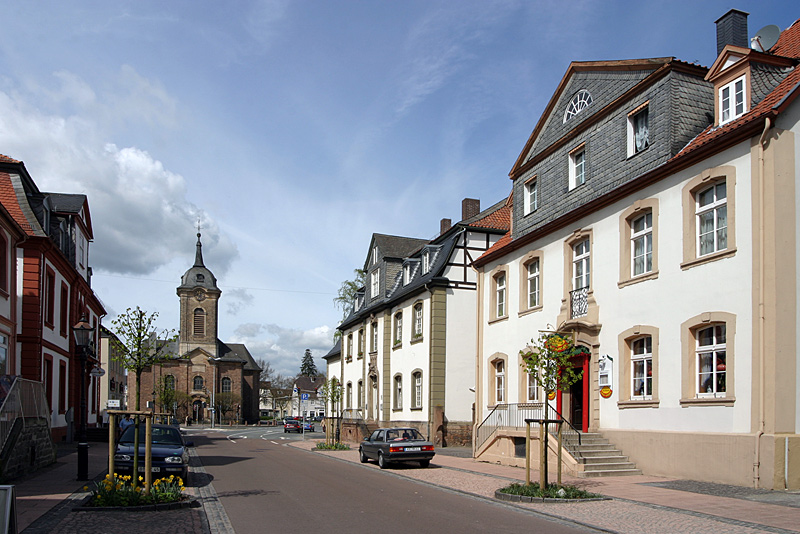


Why visit Bad Arolsen
Townapedia lists 83 museums and landmarks, 38 parks and trails, 95 places to eat, 16 places to stay and 52 attractions in and around town.
Highlights include Outdoor stage Twiste, Schanzenhof, Ausstellung der Arolsen Archives and Landauer Wasserkunst.
Weather in Bad Arolsen
Forecast from MET Norway (CC BY 4.0). Full forecast
About Bad Arolsen
Bad Arolsen (German: [baːt ˈʔaːʁɔlzn̩] , until 1997 Arolsen, Bad being the German name for Spa) is a small town in northern Hesse, Germany, in Waldeck-Frankenberg district. From 1655 until 1918 it served as the residence town of the Princes of Waldeck-Pyrmont and then until 1929 as the capital of the Waldeck Free State. The International Tracing Service has its headquarters in Bad Arolsen.
From the Wikipedia article Bad Arolsen (this version), under CC BY-SA 4.0.
Things to do52





40 more on the map.
Museums and landmarks83


Burg Mengeringhausen
Monument and historic site · 2.6 km
72 Landstraße, Bad Arolsen

71 more on the map.
Parks, trails and playgrounds38

Freizeitbad Arobella
Sports field and stadium
23 Schlesienstraße, Bad Arolsen
Su-Th 10:00-22:00; Fr-Sa 10:00-23:00


Iberg bei Hörle
Hiking and trails · 8.6 km
Kalkmagerrasen mit Waldflächen am Südwesthang des Iberg, östlich von Hörle.

Scheid bei Volkmarsen
Hiking and trails · 8.3 km
Kalk-Halbtrockenrasen mit Büschen und Bäumen, direkt südlich des Ortsrandes von Volkmarsen. Das NSG besteht aus 2 Teilfläche mit einer...

Stadtbruch von Volkmarsen
Hiking and trails · 7.1 km
Grünland mit Wald an der Twiste, am südwestlichen Ortsrand von Volkmarsen.
26 more on the map.
Restaurants and cafes95

Zur Kugelsburg
Restaurant · 8.8 km
1 Kugelsburg, Volkmarsen
Th 17:00-22:00, Fr 11:30-22:00, Sa 11:30-22:30, Su 09:00-21:00
Da Vinci
Restaurant · Italian · 0.9 km
29 Königsbergallee, Bad Arolsen
Mo,We-Su 11:30-14:30,17:30-23:30
Landgasthof Teuteberg
Restaurant · Regional · 5.3 km
8 Rhoder Straße, Schmillinghausen
Mo-Th 17:00+; Fr-Sa 12:00-14:00,17:00+; Su off
Luisen-Mühle
Restaurant · German · 1.8 km
1 Luisenmühler Weg, Bad Arolsen
Sa-Th 12:00-13:30,18:00-21:00; Fr off
Restaurant "Fairway Wetterburg"
Restaurant · German, Fish, Burger, Chicken · 3.0 km
33 Zum Wiggenberg, Bad Arolsen
Tu-Su 11:30-00:00
Schäfer's Restaurant
Restaurant · International
15 Schloßstraße, Bad Arolsen
We-Fr 18:00-21:00; Sa-Su 12:00-14:00,18:00-22:00
Zum Fischhaus
Restaurant · German · 1.6 km
117 Fischhaus, Bad Arolsen
We-Sa 12:00-18:00; Su 11:00-18:00; PH 11:00-18:00



83 more on the map.
History
The earliest documents mentioning Arolsen date back to 1131 when an Augustinian nunnery was established there with the name of "Aroldessen". The nunnery was secularized in 1526 and in 1655 became the residence of the Counts (later Princes) of Waldeck, who converted it into a stately home. It was torn down in 1710 and replaced with a new Baroque structure (1713–1728) by Friedrich Anton Ulrich, Prince of Waldeck and Pyrmont (1676–1728).
From 1918 to 1929 Arolsen was capital of the Free State of Waldeck-Pyrmont (after 1922: Free State of Waldeck), which was subsequently incorporated into Prussia.
During World War II, in 1943–1945, the Nazis operated in Arolsen a subcamp of the Buchenwald concentration camp, which housed a total of 185 prisoners, of whom 35% were from German-occupied Poland, 30% from German-occupied Russia and 15% from Germany. After the war, the town was located within the American-occupied zone of Germany, and became part of West Germany.
From the History section of Bad Arolsen on Wikipedia, under CC BY-SA 4.0.
Where to stay16
Churches and places of worship35
Kirche Braunsen
Church · Protestant · 3.8 km
4 Am Kirchenland, Bad Arolsen
Ev. Kirche Neu-Berich
Church · Protestant · 4.7 km
1 Mühlenfeldstraße, Bad Arolsen
Shopping18
Gas and EV charging6
Schools, colleges and libraries18
Healthcare10
Map of Bad Arolsen
250 places. The map loads OpenStreetMap tiles when you open it.
Getting there and nearby towns
Kassel Airport (KSF) is the nearest airport with scheduled flights listed in OpenStreetMap, 27 km away.
- Wolfhagen 12 km southeast, about 12 min by car
- Korbach 15 km southwest, about 15 min by car
- Hofgeismar 29 km northeast, about 29 min by car
- Bad Wildungen 30 km south, about 30 min by car
- Baunatal 31 km southeast, about 31 min by car
- Kassel 34 km east, about 34 min by car
- Fritzlar 33 km southeast, about 33 min by car
- Frankenberg 39 km southwest, about 39 min by car
- Lohfelden 38 km east, about 38 min by car
- Paderborn 42 km northwest, about 42 min by car
Drive times are estimates from straight-line distance, not routes.
Local news
Headlines from INDB.
Reviews, tips and questions
Loading what members have shared...
Sources and licences
- GeoNames (CC BY 4.0): population, coordinates, regions and time zone
- Mapillary (see each image): photos
- OpenStreetMap contributors (ODbL 1.0): places, airports, map data
- Wikidata (CC0 1.0): elevation, founding date, time zone, website
- Wikimedia Commons (see each image): photos
- Wikipedia (CC BY-SA 4.0): overview and history text
Photo credits
- Innenstadt Bad Arolsen, Unknown author, CC BY-SA 3.0
- Stadtkirche Chor Bad Arolsen, Clemensfranz, CC BY-SA 4.0
- Stadtkirche von Osten Bad Arolsen 2, Clemensfranz, CC BY-SA 4.0
- Stadtkirche südlicher Eingang Bad Arolsen, Clemensfranz, CC BY-SA 4.0
- Altar und Kanzel Stadtkirche Bad Arolsen, Clemensfranz, CC BY-SA 4.0
- Stadtkirche Christian Rauch Bad Arolsen, Clemensfranz, CC BY-SA 4.0
- Orgel Stadtkirche Bad Arolsen, Clemensfranz, CC BY-SA 4.0
- Glaube Liebe Hoffnung Kirche Bad Arolsen, Clemensfranz, CC BY-SA 4.0
- Stadtkirche von südost Bad Arolsen 2, Clemensfranz, CC BY-SA 4.0
- Stadtkirche von Osten Bad Arolsen, Clemensfranz, CC BY-SA 4.0
- Rathaus Bad Arolsen, OCTopus, CC BY-SA 3.0
- Bad Arolsen-St. Johannes Baptist-1-3774, GLSystem, CC BY-SA 3.0
- Bad Arolsen-Gedenkstein-2-3780, GLSystem, CC BY-SA 3.0
- Bad Arolsen-Gedenkstein-1-3777, GLSystem, CC BY-SA 3.0
- Grosse Allee Bad Arolsen-1, OCTopus, CC BY-SA 3.0
- Bad Arolsen-Diakonissenheim-1-3784, GLSystem, CC BY-SA 3.0
- ITS Bad Arolsen, OCTopus, CC BY-SA 3.0
- Bushaltestelle Krankenhaus, 2, Bad Arolsen, Landkreis Waldeck-Frankenberg, GeorgDerReisende, CC BY-SA 4.0
- Bushaltestelle Krankenhaus, 1, Bad Arolsen, Landkreis Waldeck-Frankenberg, GeorgDerReisende, CC BY-SA 4.0
- Fachwerkgebäude mit Sandstein-Gefachen, Am Schloßteich, 34454 Bad Arolsen 01, Kai Kemmann, CC BY-SA 4.0
- Fachwerkgebäude mit Sandstein-Gefachen, Am Schloßteich, 34454 Bad Arolsen 02, Kai Kemmann, CC BY-SA 4.0
- Helisosteig 4, 34454 Bad Arolsen 02, Kai Kemmann, CC BY-SA 4.0
- Helisosteig 4, 34454 Bad Arolsen 01, Kai Kemmann, CC BY-SA 4.0
- Marsberg Naturschutzgebiete Sauerland Ost 455 pk, Teta, CC BY-SA 3.0
- Bad Arolsen - Burghotel Mengeringhausen, Franzfoto, CC BY-SA 3.0
- Marsberg NSG Hummelgrund Sauerland-Ost 203, Michael Kramer, CC BY-SA 3.0
- NSG-Udorfer Mühle, Martin Lindner, CC BY-SA 3.0
- NSG Kleppwiese 9, Falkmart, CC BY-SA 4.0
- Ostfläche Naturschutzgebiet Klebberg, Martin Lindner, CC BY-SA 4.0
- Bismarckwarte im Jahr 2019, LaJo64, CC BY-SA 4.0
- Kirche Elleringhausen 2021-08-25 b, Baummapper, CC BY-SA 3.0 de
- Evangelische Kirche Massenhausen 2026, Fischer1961, CC BY-SA 4.0
- Naturschutzgebiet An der Kleppwiese 11, Falkmart, CC BY-SA 4.0
- Weinberg im NSG Glockengrund, Martin Lindner, CC BY-SA 3.0
- Hummelgrund Mai 2016, Martin Lindner, CC BY-SA 3.0
- Naturschutzgebiet Klebberg Ostfläche, Falkmart, CC BY-SA 4.0
- Marsberg-Udorf Glockenrücken Sauerland-Ost 198, Michael Kramer, CC BY-SA 3.0
- NSG 1635003 Iberg bei Hörle 2022-02-19 d, Baummapper, CC BY-SA 3.0 de
- Volkmarser Weg NSG Scheid Nord, Feuermond16, CC BY-SA 4.0
- NSG 1635024 Stadtbruch von Volkmarsen 2021-10-10 f, Baummapper, CC BY-SA 3.0 de
- Kirche Braunsen 2021-08-25 a, Baummapper, CC BY-SA 3.0 de
- Kirche Elleringhausen 2021-08-25 c, Baummapper, CC BY-SA 3.0 de
- Kirche Külte 2022-02-19 a, Baummapper, CC BY-SA 3.0 de
- Marsberg-Canstein Sauerland Ost 440 pk, Teta, CC BY-SA 3.0
- BadArolsen001, Bytfisch, CC BY-SA 4.0
- Volkmarsen - 2018-04-27 - Iberg bei Hörle (06), Tsungam, CC BY-SA 4.0
- Street-level photo, derlipper, CC BY-SA 4.0
- Street-level photo, ramap, CC BY-SA 4.0
- Street-level photo, hejbjarne, CC BY-SA 4.0
- Street-level photo, sreeh, CC BY-SA 4.0
- Street-level photo, zuse, CC BY-SA 4.0
- Street-level photo, sreeh, CC BY-SA 4.0
- Street-level photo, thetornado76, CC BY-SA 4.0
- Street-level photo, zuse, CC BY-SA 4.0
- Street-level photo, thetornado76, CC BY-SA 4.0
- Street-level photo, thetornado76, CC BY-SA 4.0
- Street-level photo, rb61, CC BY-SA 4.0
- Street-level photo, zuse, CC BY-SA 4.0
- Street-level photo, zuse, CC BY-SA 4.0
- Street-level photo, thetornado76, CC BY-SA 4.0
- Street-level photo, derlipper, CC BY-SA 4.0
- Street-level photo, derlipper, CC BY-SA 4.0
- Street-level photo, thetornado76, CC BY-SA 4.0
- Street-level photo, zuse, CC BY-SA 4.0
- Street-level photo, sreeh, CC BY-SA 4.0
- Street-level photo, zuse, CC BY-SA 4.0
- Street-level photo, derlipper, CC BY-SA 4.0
- Street-level photo, troher15, CC BY-SA 4.0
- Street-level photo, rb61, CC BY-SA 4.0
- Street-level photo, rb61, CC BY-SA 4.0


Page built November 8, 2026. Spotted a mistake? Tell us or suggest a place.