


Why visit Leutershausen
Townapedia lists 52 museums and landmarks, 9 parks and trails, 34 places to eat, 7 places to stay and 28 attractions in and around town.
Highlights include Aubühl, Bromberg, Kreuzstein and Pfarrhaus.
Weather in Leutershausen
Forecast from MET Norway (CC BY 4.0). Full forecast
About Leutershausen
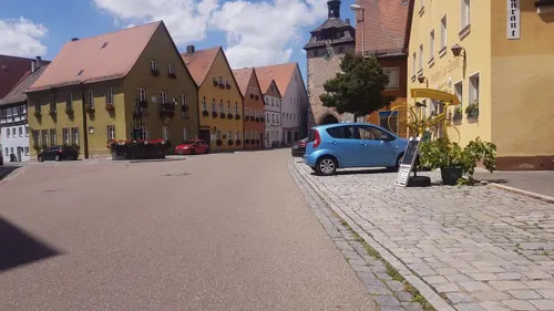
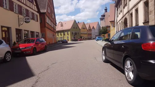
Leutershausen (German pronunciation: [lɔʏtɐsˈhaʊzn̩] ) is a town in the district of Ansbach, in Bavaria, Germany. It is situated on the river Altmühl, 12 km west of Ansbach.
From the Wikipedia article Leutershausen (this version), under CC BY-SA 4.0.
Things to do28

16 more on the map.
Museums and landmarks52





40 more on the map.
Parks, trails and playgrounds9

Altmühlbad Leutershausen
Sports field and stadium · 0.6 km
Naturfreibad Altmühlbad Leutershausen
Schillingsfürster Straße, Leutershausen
Mo-Su,PH 09:00-21:00

Golfclub Ansbach
Golf course · 6.9 km
9 hole Par 34 + 6 hole Par 30 Academy course
35 Rothenburger Straße, Colmberg




Restaurants and cafes34

Bernie’s Fun-Pizzeria
Restaurant · Pizza · 6.5 km
7 Wirtsgasse, Buch am Wald
We-Sa 17:00-22:00; Su 15:00-22:00




Bäckerei Beck
Bakery · 6.1 km
18 Weinberger Straße, Aurach
Mo,Sa 06:00-12:00; Tu-Fr 06:00-18:00; Su,PH off
22 more on the map.
History
Leutershausen was probably founded by Frankish settlers around 800. For the first time it is referred to in a privilege of Emperor Otto III as "Liuthereshusunin" in 1000.
On the 19th of April, 1945, the village was almost completely destroyed by Allied fighter-bombers.
From the History section of Leutershausen on Wikipedia, under CC BY-SA 4.0.
Where to stay7
Churches and places of worship17
St. Georg
Church · Lutheran · 3.7 km
9 Kirchenweg, Neunkirchen bei Leutershausen
St. Johannis Baptista
Church · Lutheran · 1.9 km
1 Hauptstraße, Wiedersbach
Shopping7
Gas and EV charging12
Schools, colleges and libraries6
Healthcare2
Map of Leutershausen
174 places. The map loads OpenStreetMap tiles when you open it.
Getting there and nearby towns
Illesheim Army Heliport (ILH) is the nearest airport with scheduled flights listed in OpenStreetMap, 19 km away.
- Ansbach 13 km east, about 13 min by car
- Feuchtwangen 16 km south, about 16 min by car
- Rothenburg ob der Tauber 19 km northwest, about 19 min by car
- Bad Windsheim 23 km north, about 23 min by car
- Petersaurach 25 km east, about 25 min by car
- Dinkelsbühl 26 km south, about 26 min by car
- Markt Erlbach 28 km northeast, about 28 min by car
- Satteldorf 28 km southwest, about 28 min by car
- Rot am See 29 km west, about 29 min by car
- Crailsheim 31 km southwest, about 31 min by car
Drive times are estimates from straight-line distance, not routes.
Local news
Headlines from INDB.
Reviews, tips and questions
Loading what members have shared...
Sources and licences
- GeoNames (CC BY 4.0): population, coordinates, regions and time zone
- Mapillary (see each image): photos
- OpenStreetMap contributors (ODbL 1.0): places, airports, map data
- Wikidata (CC0 1.0): elevation, founding date, time zone, website
- Wikimedia Commons (see each image): photos
- Wikipedia (CC BY-SA 4.0): overview and history text
Photo credits
- Leutershausen, ehemaliges markgräfliches Stadtschloss 004, Wolkenkratzer, CC BY-SA 4.0
- Leutershausen Altmühlbad 01, Heinrich Stürzl, CC BY-SA 4.0
- Kriegerdenkmal Leutershausen - Ausschnitt Soldat, Mausemarie, CC BY-SA 4.0
- Kriegerdenkmal Leutershausen - Seitenansicht, Mausemarie, CC BY-SA 4.0
- Kriegerdenkmal Leutershausen - Gesamtansicht, Mausemarie, CC BY-SA 4.0
- Leutershausen mit Altmühlwiesen, Mausemarie, CC BY-SA 4.0
- Leutershausen Altmühlbad 02, Heinrich Stürzl, CC BY-SA 4.0
- Altmühlbad Leutershausen, außerhalb der Saison, Mausemarie, CC BY-SA 4.0
- Altmühlbrücke Leutershausen, Mausemarie, CC BY-SA 4.0
- Altmühl-Steinbrücke in Leutershausen - panoramio, Siegmar S., CC BY-SA 3.0
- Altmühl-Steinbrücke in Leutershausen, Padd y, CC BY-SA 4.0
- Friedhof von Leutershausen im Januar 2021, Mausemarie, CC BY-SA 4.0
- Aussegnungshalle im Friedhof von Leutershausen, Mausemarie, CC BY-SA 4.0
- Aussegnungshalle und Eingangstor des Friedhofs von Leutershausen, Mausemarie, CC BY-SA 4.0
- Kirche-St.-Ursula-Colmberg-10-2020, 19Wilhelm18, CC BY-SA 4.0
- Leutershausen, Am Markt 6-001, Tilman2007, CC BY 3.0
- Leutershausen, Hans-Schreyer-Straße 17-002, Tilman2007, CC BY 3.0
- Steinkreuze bei Neunkirchen, Padd y, CC BY-SA 4.0
- Weißenkirchberg, Pfarrhaus-001, Tilman2007, CC BY 3.0
- Gustav Weisskopf Museum Leutershausen, Stefan Karl, CC BY-SA 4.0
- Neunkirchen-Siedlung (4), Steinkreuze, Rensi, CC0
- Leutershausen Dekanatsamt 001, Tilman2007, CC BY-SA 3.0
- Scheerweiher, EapClochydd, CC BY-SA 3.0
- Leutershausen 8, Klaus Graf, CC BY 2.5
- Weißenkirchberg, St. Wenzeslaus-001, Tilman2007, CC BY 3.0
- Neunkirchen (6), St. Georgskirche, Rensi, CC0
- Häslabronn 9 Colmberg 20180216 002, Tilman2007, CC BY-SA 4.0
- Wiedersbach St. Johannis Baptista 001, Tilman2007, CC BY 3.0
- Auerbach-Ansicht von Süden aus dem Ort mit umgebenden Häusern-24032012, Robert Pietschmann, CC BY-SA 4.0
- Jochsberg 2013-07 (1) Kirche, Rensi, CC0
- D-5-71-114-5 Aurach 20220219 0232, Tilman2007, CC BY-SA 4.0
- Neunstetten - St. Vitus, Wave at German Wikipedia, Public domain
- Burg Colmberg 2, Rainer Lippert → Derivative work: Steffen Schmitz ( Carschten ), CC0
- Aurach, Kirche St. Peter und Paul, Rauenstein, CC BY-SA 3.0
- Häslabronn 2014-11 (14), Rensi, CC0
- Leutershausen St. Peter, Mausemarie, CC BY-SA 4.0
- Weißenkirchberg (Leutershausen) (3), Rensi, CC0
- Gustav Weißkopf Denkmal (cropped), Muck, CC BY-SA 4.0
- Gustav Weißkopf Denkmal, Muck, CC BY-SA 4.0
- Mosaikbank vor dem Kulturhaus - panoramio, Siegmar S., CC BY-SA 3.0
- Street-level photo, changchun1, CC BY-SA 4.0
- Street-level photo, changchun1, CC BY-SA 4.0
- Street-level photo, changchun1, CC BY-SA 4.0
- Street-level photo, changchun1, CC BY-SA 4.0
- Street-level photo, zuse, CC BY-SA 4.0
- Street-level photo, changchun1, CC BY-SA 4.0
- Street-level photo, changchun1, CC BY-SA 4.0


Page built November 9, 2026. Spotted a mistake? Tell us or suggest a place.