


Randolph Town, Massachusetts
Randolph Town is a city of 34,878 people in Norfolk County, Massachusetts, founded in 1710.
Why visit Randolph Town
Townapedia lists 50 museums and landmarks, 65 parks and trails, 78 places to eat, 7 places to stay and 13 attractions in and around town.
Highlights include AMC Braintree 10, Chickatawbut Observation Tower, Holbrook Square Historic District and Jonathan Belcher House.
July is the warmest month, with average highs of 82°F; January lows average 18°F, and about 70 inches of snow fall in a normal year.
Weather in Randolph Town
Forecast from the National Weather Service. Full forecast
About Randolph Town
Randolph is a suburban city in Norfolk County, Massachusetts, United States. At the 2020 census, the city population was 34,984. Randolph adopted a charter effective January 2010 providing for a council-manager form of government instead of the traditional town meeting. Randolph is one of thirteen Massachusetts municipalities that have applied for, and been granted, city forms of government but wish to retain "The town of" in their official names.
From the Wikipedia article Randolph, Massachusetts (this version), under CC BY-SA 4.0.
Things to do13

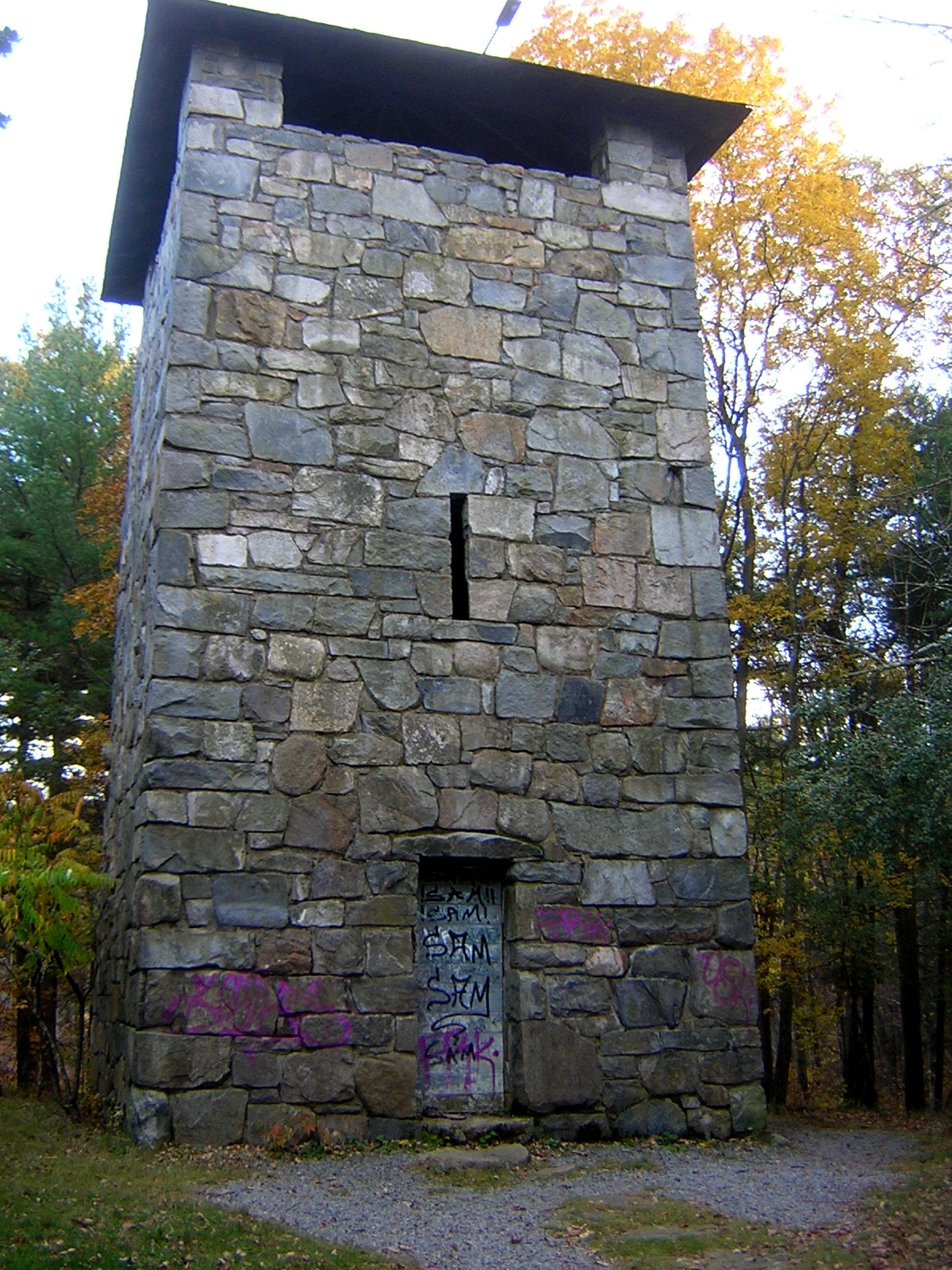
Chickatawbut Observation Tower
Monument and historic site · National Register of Historic Places · 3.2 mi
Observation tower in Quincy, United States of America

Great Blue Hill Observation Tower
Monument and historic site · National Register of Historic Places · 3.9 mi
Observation tower in Milton, United States of America

Blue Hills Ski Area
Ski area · 4.2 mi
Ski area in Canton, Massachusetts

1 more on the map.
Museums and landmarks50

Holbrook Square Historic District
Monument and historic site · National Register of Historic Places · 2.7 mi
Historic district in Massachusetts, United States

Jonathan Belcher House
Monument and historic site · National Register of Historic Places · 0.7 mi
Historic house in Massachusetts

Blue Hill Meteorological Observatory
Monument and historic site · National Register of Historic Places · 3.9 mi
Weather observatory in Milton, United States

Blue Hills Reservation Parkways
Monument and historic site · National Register of Historic Places · 3.2 mi
Historic district in Massachusetts, United States
Blue Hills State Police Barracks Station H-7
Monument and historic site · National Register of Historic Places · 3.2 mi
Police station in Milton, Massachusetts , United States

Brookwood Farm
Monument and historic site · National Register of Historic Places · 3.6 mi
Farm in Canton, Massachusetts, United States

Canton Corner Historic District
Monument and historic site · National Register of Historic Places · 4.3 mi
Historic district in Massachusetts, United States

Comfort Station
Monument and historic site · National Register of Historic Places · 4.4 mi
Public toilet in Milton, Massachusetts

Edward J. Lennon House
Monument and historic site · National Register of Historic Places · 4.5 mi
Historic house in Massachusetts, United States

Eliot Memorial Bridge
Bridge · National Register of Historic Places · 3.9 mi
Footbridge in Massachusetts, United States of America

Eustis Estate
Monument and historic site · National Register of Historic Places · 4.6 mi
Historic home and estate in Milton, Massachusetts

Gen. Sylvanus Thayer House
Monument and historic site · National Register of Historic Places · 3.1 mi
Historic house in Massachusetts, United States
38 more on the map.
Parks, trails and playgrounds65






53 more on the map.
Restaurants and cafes78

Gotcha Fusion
Cafe · Bubble Tea · 0.9 mi
"Bubble tea and Mochi Donut"
324 North Main Street, Randolph
Mo-Sa 10:00-20:00; Su 11:00-18:00

C & J Cuisine
Restaurant · Chinese, Japanese · 1.6 mi
183 South Main Street
Mo-Th 12:30-21:00; Fr,Sa 12:30-22:00; Su 12:30-21:30
Golden Pacific II
Restaurant · Chinese · 0.8 mi
346 North Main Street
Mo-Th 11:00-22:00; Fr,Sa 11:00-23:00; Su 12:00-22:00
LaScala Restaurant
Restaurant · Italian · 1.0 mi
1070 North Main Street, Randolph
Mo-Fr 11:30-16:00,16:30-23:00; Sa 11:30-23:00; Su 13:00-22:00
Malai Thai Cuisine
Restaurant · Thai · 0.9 mi
266 North Main Street, Randolph
Mo-Sa 11:30-22:00; Su 14:00-22:00
Ocean City
Restaurant · Chinese · 1.1 mi
61 Diauto Drive
Mo-Th 11:30-22:30; Fr-Sa 11:30-00:00; Su 12:00-22:30
Pho So 1 Boston
Restaurant · Vietnamese · 1.1 mi
51 Memorial Parkway
Mo-Sa 10:00-22:00; Su 10:00-21:00

Bamboo Moon
Restaurant · Sushi, Chinese · 1.2 mi
41 North Main Street
Mo-Th 11:30-22:30; Fr-Sa 11:30-23:30; Su 13:00-22:30
66 more on the map.
History
It was called Cochaticquom by the local Cochato tribes. The town was incorporated in 1793 from what was formerly the south precinct of the town of Braintree. According to the centennial address delivered by John V. Beal, the town was named after Peyton Randolph, first president of the Continental Congress.
Randolph was formerly the home of several large shoe companies. Many popular styles were made exclusively in Randolph, including the "Randies". At the time of Randolph's incorporation in 1793, local farmers were making shoes and boots to augment household incomes from subsistence farming. In the next half century, this sideline had become the town's major industry, attracting workers from across New England, Canada and Ireland and later from Italy and Eastern Europe, each adding to the quality of life in the town. By 1850, Randolph had become one of the nation's leading boot producers, shipping boots as far away as California and Australia.
The decline of the shoe industry at the beginning of the twentieth century led to Randolph's evolution as a suburban residential community. Boot and shoe making has been supplanted by light manufacturing and service industries. The town's proximity to major transportation networks has resulted in an influx of families from Boston and other localities who live in Randolph but work throughout the metropolitan area.
From the History section of Randolph, Massachusetts on Wikipedia, under CC BY-SA 4.0.
Where to stay7
Ponkapoag Camp of Appalachian Mountain Club
Campground · National Register of Historic Places · 2.0 mi
Churches and places of worship22
All Souls Church
Church · National Register of Historic Places · 4.0 mi
Holbrook Kingdom Hall of Jehovah's Witnesses
Place of worship · Jehovahs Witness · 2.6 mi
314 North Franklin Street, Holbrook
First Congregational Church
Church · United Church Of Christ · 1.3 mi
1 South Main Street, Randolph
New Jerusalem Evangelical Baptist Church
Church · Evangelical · 0.5 mi
871 North Main Street, Randolph
Saint Bernadette Catholic Church
Church · Catholic · 0.9 mi
1027 North Main Street
Shopping7
Gas and EV charging24
Schools, colleges and libraries62
Healthcare7
Map of Randolph Town
250 places. The map loads OpenStreetMap tiles when you open it.
Climate by month
Monthly table
| Month | High | Low | Rain | Snow |
|---|---|---|---|---|
| Jan | 35°F | 18°F | 4.5 in | 18.6 in |
| Feb | 37°F | 20°F | 4.0 in | 18.2 in |
| Mar | 44°F | 27°F | 5.5 in | 15.0 in |
| Apr | 56°F | 38°F | 4.8 in | 2.8 in |
| May | 67°F | 48°F | 3.8 in | 0.0 in |
| Jun | 75°F | 58°F | 4.6 in | 0.0 in |
| Jul | 82°F | 64°F | 3.5 in | 0.0 in |
| Aug | 80°F | 63°F | 3.9 in | 0.0 in |
| Sep | 73°F | 56°F | 4.1 in | 0.0 in |
| Oct | 61°F | 44°F | 5.5 in | 0.7 in |
| Nov | 50°F | 34°F | 4.3 in | 1.8 in |
| Dec | 40°F | 25°F | 5.4 in | 12.6 in |
U.S. Climate Normals 1991-2020 for Blue Hill Coop Hcn (4 mi away), NOAA NCEI.
People and cost of living
American Community Survey 5-year estimates, 2020-2024, U.S. Census Bureau. Estimates have margins of error, larger for small towns.
Disaster history
Norfolk County has had 25 federal disaster declarations since 2000, most often for snowstorms.
- 2023-09-15: Hurricane Lee (Hurricane)
- 2022-04-18: Severe Winter Storm And Snowstorm (Snowstorm)
- 2020-03-27: Covid-19 Pandemic (Biological)
- 2020-03-13: Covid-19 (Biological)
- 2018-07-19: Severe Winter Storm And Snowstorm (Snowstorm)
- 2018-06-25: Severe Winter Storm And Flooding (Severe Storm)
OpenFEMA disaster declarations summaries.
Getting there and nearby towns
Norwood Memorial Airport (OWD) is the nearest airport with scheduled flights listed in OpenStreetMap, 6 miles away.
- Braintree Town 3 mi northeast, about 5 min by car
- Holbrook 4 mi southeast, about 6 min by car
- Milton 5 mi north, about 7 min by car
- Quincy 6 mi north, about 10 min by car
- Brockton 7 mi south, about 11 min by car
- Abington 7 mi southeast, about 11 min by car
- Norwood 7 mi west, about 12 min by car
- Dedham 8 mi northwest, about 13 min by car
- Boston 11 mi north, about 17 min by car
- Brookline 11 mi northwest, about 18 min by car
Drive times are estimates from straight-line distance, not routes.
Local news
Headlines from INDB, the NEMICO news database.
Reviews, tips and questions
Loading what members have shared...
Sources and licences
- NCES EDGE (Public domain): public schools
- NOAA NCEI U.S. Climate Normals 1991-2020 (Public domain): climate by month
- OpenFEMA (Public domain): disaster declarations
- OpenStreetMap contributors (ODbL 1.0): places, airports, map data
- U.S. Census Bureau (Public domain): population, income, housing, education, commute
- Wikidata (CC0 1.0): elevation, founding date, time zone, website, landmarks and historic places
- Wikimedia Commons (see each image): photos
- Wikipedia (CC BY-SA 4.0): overview and history text
Photo credits
- Randolph Town Hall, Marcbela (Marc N. Belanger), Public domain
- Ponkapoag AMC FolsomCabin, User:Magicpiano, CC BY-SA 4.0
- Holbrook Town Hall, MA, John Phelan, CC BY 3.0
- Jonathan Belcher House Randolph MA, Jameslwoodward, CC BY-SA 3.0
- Suffolk Resolves House Milton MA 04, Jameslwoodward, CC BY-SA 3.0
- Thomas Curtis House, Sswonk, CC BY-SA 3.0
- Refreshment Pavilion MIlton MA 03, Jameslwoodward, CC BY-SA 3.0
- Lucius Clapp Memorial, Stoughton MA, John Phelan, CC BY 3.0
- Noah Curtis House, Sswonk, CC BY-SA 3.0
- Quincy Water Company Pumping Station Site, Jameslwoodward, CC BY-SA 3.0
- S. H. Barnicoat Monuments Site Quincy MA, Jameslwoodward, CC BY-SA 3.0
- All Souls Church, Braintree MA, John Phelan, CC BY-SA 3.0
- Edward J Lennon House Quincy MA, Jameslwoodward, CC BY-SA 3.0
- QuincyMA RailwayIncline 1, Magicpiano, CC BY-SA 3.0
- Eliot Tower Milton MA 03, Jameslwoodward, CC BY-SA 3.0
- Lyons Turning Mill Quincy MA 04, Jameslwoodward, CC BY-SA 3.0
- Eustis Estate, Canton Ave., Milton, Massachusetts, Suzanne Grudem, CC BY-SA 4.0
- Great Blue Hill Weather Station Milton MA 03, Jameslwoodward, CC BY-SA 3.0
- Roberts School, Holbrook MA, John Phelan, CC BY 3.0
- Parson Barnard House, Fletcher6, CC BY 4.0
- CantonMA RedmanFarmHouse, User:Magicpiano, CC BY-SA 4.0
- RandolphMA StetsonHall, User:Magicpiano, CC BY-SA 4.0
- Chickatawbut Observation Tower Quincy MA 02, Jameslwoodward, CC BY-SA 3.0
- Braintree Old Library, Marcbela (Marc N. Belanger), Public domain
- Washington Street, Canton MA, Jameslwoodward, CC BY-SA 3.0
- Question Solomon Nightengale House Quincy MA, Jameslwoodward, CC BY-SA 3.0
- Stoughton station from crosswalk, April 2016, Pi.1415926535, CC BY-SA 3.0
- Eliot Bridge Milton MA 04, Jameslwoodward, CC BY-SA 3.0
- Gen. Sylvanus Thayer House, Braintree MA, John Phelan, CC BY 3.0
- Brookwood Farm MA 01, Jameslwoodward, CC BY-SA 3.0
- MiltonMA WakefieldTrustArboretum1, Magicpiano, CC BY-SA 4.0
- Comfort Station Milton MA 01, Jameslwoodward, CC BY-SA 3.0
- Scotts Woods HD Milton MA, Jameslwoodward, CC BY-SA 3.0
- WeymouthMA PondStreetSchool, User:Magicpiano, CC BY-SA 4.0
- MDC Stable MA 02, Jameslwoodward, CC BY-SA 3.0
- Mac Attack!!!, Byron A. Nash, CC BY-SA 2.0
- BAT route 12 bus in Randolph, January 2017, Beantowndude316 from USA, CC BY 2.0
- BAT route 12 bus in Randolph (2), July 2017, Beantowndude316 from USA, CC BY 2.0
- Dighton and Somerset right of way in Randolph, June 2017, Pi.1415926535, CC BY-SA 4.0
- MBTA route 240 bus in Randolph, June 2018, Beantowndude316 from USA, CC BY 2.0


Page built October 30, 2026. Spotted a mistake? Tell us or suggest a place.