
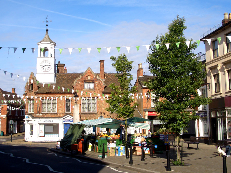


Ampthill, United Kingdom
Ampthill is a town of 20,026 people in England, United Kingdom.
Why visit Ampthill
Townapedia lists 11 museums and landmarks, 13 parks and trails, 47 places to eat and 1 place to stay in and around town.
Highlights include Ruxox Cell, Ailesbury Mausoleum, Cut-throat Meadow and Flitwick Moor.
Weather in Ampthill
Forecast from MET Norway (CC BY 4.0). Full forecast
About Ampthill
Ampthill () is a town and civil parish in the Central Bedfordshire district of Bedfordshire, England. It lies between Bedford and Luton. At the 2021 census it had a population of 8,825.
From the Wikipedia article Ampthill (this version), under CC BY-SA 4.0.
Travel tips from other travellers: Ampthill on Wikivoyage (CC BY-SA 4.0).
Photos of Ampthill


Museums and landmarks11

Ruxox Cell
Monument and historic site · 1.4 mi
Moated site in Flitwick, Bedfordshire, England, UK

Ailesbury Mausoleum
Monument and historic site · 1.6 mi
Mausoleum in Maulden, Central Bedfordshire, England, UK

De Grey Mausoleum
Monument and historic site · 2.0 mi
Grade I listed building in Flitton, Central Bedfordshire, England, UK


Katherine's Cross Ampthill Park
Monument and historic site · 0.7 mi
Architectural structure in Ampthill, Central Bedfordshire, England, UK
Amphill Water Pump
Monument and historic site · 0.4 mi
Https://www.ampthill-tc.gov.uk/amenities/town-pump https://historicengland.org.uk/listing/the-list/list-entry/1321449?section=overview
Parks, trails and playgrounds13



Ampthill Park
Park · 1.0 mi
Country house and former country estate in Ampthill, Bedfordshire, England, UK

Flitwick Football Centre
Sports field and stadium · 0.8 mi
Ampthill Road, Flitwick

1 more on the map.
Restaurants and cafes47
Wakey Joes
Cafe · Coffee Shop, Cake, Breakfast, Juice · 0.6 mi
A kiosk takeaway café serving wooden hill coffee, tea and Matcha. Speciality cakes including Vegan and Gluten Free options. Snacks...
Abbey Lane, Ampthill
Mo-Fr 08:00-16:00



35 more on the map.
Where to stay1

History
The name 'Ampthill' is of Anglo-Saxon origin. The first settlement was called 'Æmethyll', which literally means either 'anthill' or 'ant-infested hill'. In the Domesday Book, Ampthill is referred to as 'Ammetelle', with the landholder in 1086 being Nigel de la Vast. The actual entry reads: Ammetelle: Nigel de la Vast from Nigel d'Aubigny. A further variation may be 'Hampthull', in 1381.
In 1219 King Henry III granted a charter for a weekly market to be held on a Thursday. In 2019 the market celebrated 800 years.
Henry VIII was a frequent visitor to Ampthill Castle, and it was there that Catherine of Aragon lived from 1531 until her marriage was annulled in 1533, when she was moved to Kimbolton. The castle was built in the 15th century by Sir John Cornwall, later Lord Fanhope, from ransoms after the Battle of Agincourt. Today a park remains just north of the town centre, site of Ampthill's former castle, where Henry VIII would come and hunt. It was in the castle's Great Dining Room that Queen Catherine defiantly received news of the end of her marriage. A cross erected in the 1770s marks the site of this important building which is set within Ampthill Great Park, a "Capability" Brown landscape.
Read more of the history
In 1542 an Act of Parliament created the 'Honour of Ampthill', an area of 45 parishes around the town, including 11 in Buckinghamshire, in which the crown owned extensive property and the manorial rights. The Honour was sold to the Dukes of Bedford in parts between 1730 and 1881.
In the mid-1780s, John Fitzpatrick, the 2nd Earl of Upper Ossory, led a campaign to improve the town centre. He created the current market place, erected the water pump and built a new clock tower. Lord Upper Ossory was also responsible for a cross commemorating Catherine of Aragon, with an inscription by Horace Walpole, and a row of thatched cottages built between 1812 and 1816 to house his estate workers.
On the death of Lord Upper Ossory in 1818, Ampthill Park became the seat of Lord Holland in whose time Holland House in Kensington, London, became famous as a gathering place for intellectuals. Lady Holland planted trees to create the Alameda walk, inspired by the Almeida in Madrid. Ampthill Park was later home to Baron Ampthill.
In 1835 Ampthill became the centre of a Poor Law Union, and a workhouse was built on Dunstable Street shortly afterwards to serve the town and surrounding parishes.
The London and North Western Railway's Bedford Railway branch line opened in 1846, with a station at Millbrook, three miles north-west of Ampthill. At different times this station was known as "Ampthill", "Ampthill (Marston)" and "Millbrook for Ampthill", before the name was changed to "Millbrook" in 1910. In 1868 the Midland Railway opened its main line from the Midlands to London. In order to cross the ridge of high ground on which Ampthill stands, the Ampthill Tunnel was built to the west of the town. Ampthill railway station was built to the south of the tunnel, at the bottom of the hill and over a mile from the market place. This station closed in 1959.
During WWII there was a farming camp near Ampthill where volunteers recovered sugarbeet and were accommodated in tents in the grounds of a nearby country mansion.
Recent years have witnessed substantial development in Ampthill and the surrounding area. The former site of the old Ampthill Brewery in Bedford Street area was substantially redeveloped in 2006/2007, with the demolition of a Shell petrol station, shopping arcade and small Budgens supermarket, to make way for a new Waitrose supermarket, an improved town car park and a development of shops and apartments known as Oxlet House. The supermarket opened on 29 September 2006, with Oxlet House being completed in late 2007. Since then, two major new housing estates have been constructed on the south side of town - Ampthill Heights to the west and Ampthill Gardens to the east. Other significant housing developments have been completed behind The Limes, at the former site of Russell House, off Swaffield Close and in the old orchard off Church Street. A microbrewery reviving the name of the Ampthill Brewery was started in 2014 on the Ampthill industrial estate but ceased operations the following year.
From the History section of Ampthill on Wikipedia, under CC BY-SA 4.0.
More about Ampthill
Economy
Ampthill is a commercial centre for surrounding villages; it has several pubs, restaurants, a Waitrose supermarket and a selection of small independent specialist shops. A number of small businesses such as solicitors, estate agents, financial and professional services, hairdressers, are also located in town, with larger businesses found on the commercial and industrial developments on the outskirts, along the town's bypass.
Ampthill is one of the most expensive places to buy a house in Bedfordshire, even in comparison with other mid-Bedfordshire towns such as neighbouring Flitwick, and Cranfield. In a survey, it was found that the majority of Ampthill's workers are employed locally, with around 20% working in Ampthill itself, and most of the remainder travelling to nearby centres of employment such as Bedford, Luton and Milton Keynes. Around 13% of workers commute from Ampthill to London daily. The survey also found that the turnover of residents was low, most having been in Ampthill for well over a decade.
Arts and culture
Ampthill formerly hosted its own annual festival weekend in the summer. This event included two music events: a live rock music event "AmpRocks", which hosted acts such as Razorlight and Toploader, and the "Ampthill Park Proms", where classical music was performed by bands such as Ampthill Orchestra, Ampthill Band and Redborne Jazz Band from the local upper school. This event was held in Ampthill Great Park, where a temporary soundstage was erected to entertain local residents.
The event also included the Ampthill Gala, which began with a parade of floats around the town, built and staffed by people from the local schools and communities. The parade ended at Ampthill Cricket Club, located just outside of Ampthill Great Park, where a variety of stalls set up by local charities and businesses could be found, as well as a number of fairground attractions.
The Ampthill Festival was first held in 1981 and was held annually with some exceptions. In 2023 the event was cancelled due to adverse weather conditions and as a result the company behind the festival, Ampthill Festival CIC, entered administration due to a lack of funding and the event was permanently cancelled in 2024.
From the Wikipedia article Ampthill, under CC BY-SA 4.0.
Notable people from Ampthill
- Richard Nicollsfirst English colonial governor of New York province
- Hugh BillingtonEnglish footballer (1916-1988)
- Cecil LowtherBritish Army officer and politician (1869-1940)
- George MooreAustralian cricketer (1820-1916)
- Thomas BrownEnglish cricketer, born 1854
- Jemmy MooreBritish cricketer (1839-1890)
- Toby LittBritish writer
- George Charles CrickBritish paleontologist
- Benjamin LeePolitician, shipowner and magistrate from New South Wales, Australia
- Arthur SkinnerBritish sports shooter
- John MorrisEnglish first-class cricketer (1880-1960)
Born in Ampthill, according to Wikidata (CC0). Each name links to its Wikipedia article.
Churches and places of worship12
Shopping9
Gas and EV charging3
Schools, colleges and libraries6
Healthcare2
Map of Ampthill
104 places. The map loads OpenStreetMap tiles when you open it.
Getting there and nearby towns
London Luton Airport (LTN) is the nearest airport with scheduled flights listed in OpenStreetMap, 12 miles away.
- Flitwick 2 mi south, about 3 min by car
- Kempston 6 mi north, about 10 min by car
- Bedford 8 mi north, about 12 min by car
- Henlow 9 mi east, about 14 min by car
- Newport Pagnell 10 mi northwest, about 17 min by car
- Luton 11 mi south, about 17 min by car
- Milton Keynes 11 mi west, about 18 min by car
- Biggleswade 11 mi northeast, about 17 min by car
- Sandy 11 mi northeast, about 18 min by car
- Baldock 13 mi east, about 21 min by car
Drive times are estimates from straight-line distance, not routes.
Towns near Ampthill


Keep exploring
Local news
Headlines from INDB.
Reviews, tips and questions
Loading what members have shared...
Sources and licences
- GeoNames (CC BY 4.0): population, coordinates, regions and time zone
- Mapillary (see each image): photos
- OpenStreetMap contributors (ODbL 1.0): places, airports, map data
- Wikidata (CC0 1.0): elevation, founding date, time zone, website, landmarks and historic places
- Wikimedia Commons (see each image): photos
- Wikipedia (CC BY-SA 4.0): overview and history text
Photo credits
- Ampthill market place, APB-CMX at English Wikipedia, Public domain
- 12 Dunstable Street, Ampthill (October 2023), Richard Kelly, CC BY-SA 4.0
- Ruxox Farm moated site 15, Simon Burchell, CC BY-SA 4.0
- Ailesbury Mausoleum 04, Simon Burchell, CC BY-SA 4.0
- De Grey M, Tatraplan at English Wikipedia, Public domain
- Cut-Throat Meadow 3, Dudley Miles, CC BY-SA 4.0
- River Flit in Flitwick Moor 3, Dudley Miles, CC BY-SA 4.0
- Houghton House, APB-CMX at English Wikipedia, Public domain
- Houghton House, Bedfordshire, 2026, Eothan, CC BY-SA 4.0
- A Bedfordshire Rural Water Tender, Slinkierbus268, CC BY-SA 4.0
- Street-level photo, wasd42, CC BY-SA 4.0
- Street-level photo, wasd42, CC BY-SA 4.0
- Street-level photo, sk53, CC BY-SA 4.0
- Street-level photo, ris, CC BY-SA 4.0
- Street-level photo, mappo2, CC BY-SA 4.0
Page built November 10, 2026. Spotted a mistake? Tell us or suggest a place.