



Chicksands, United Kingdom
Chicksands is a town of 1,396 people in England, United Kingdom.
Why visit Chicksands
Townapedia lists 3 museums and landmarks, 3 parks and trails, 19 places to eat, 1 place to stay and 1 attraction in and around town.
Highlights include DITG Theatre, Military Intelligence Museum, Cainhoe Castle and Wrest Park.
Weather in Chicksands
Forecast from MET Norway (CC BY 4.0). Full forecast
About Chicksands
Chicksands is a village in the civil parish of Campton and Chicksands in the Central Bedfordshire district of Bedfordshire, England. It gives its name to MOD Chicksands, a military base which was developed from the 1930s on the Chicksands Priory estate. The village is on the River Flit and lies immediately west of the town of Shefford. At the 2021 census the Chicksands built up area as defined by the Office for National Statistics (which excludes part of the MOD Chicksands base) had a population of 731.
From the Wikipedia article Chicksands (this version), under CC BY-SA 4.0.
Things to do1

Museums and landmarks3


Cainhoe Castle
Monument and historic site · 2.3 mi
11th century Norman castle in England

George Montague Dunk Earl of Halifax memorial
Monument and historic site · 1.2 mi
Parks, trails and playgrounds3

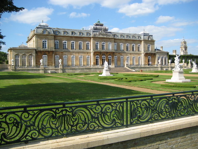
Wrest Park
Park · 3.3 mi
Country estate near Silsoe, Bedfordshire, England, UK

Old Warden Tunnel nature reserve
Park · 3.0 mi
Nature reserve in the United Kingdom
Restaurants and cafes19



Rose Buds @ Duck Lane
Cafe · 1.3 mi
2-4 High Street, Shefford
Tu-Fr 09:30-15:30; Sa 09:00-13:00

7 more on the map.
History
Chicksands appears in the Domesday Book of 1086, where it is listed under the variations Chichesana and Chichesane. William de Cairon was then the tenant of the Bishop of Lincoln, along with three freemen and Walter, holding from Azelina, wife of Ralph Tailbois, as part of her dowry. The place-name itself derives from Old English, meaning “Cicca’s sands,” with Cicca being a personal name and sands referring to the sandy soil of the district.
One of the most significant landmarks in the area is Chicksands Priory, founded around 1150. The priory was established for the Gilbertine Order, the only monastic order of English origin. Following the Dissolution of the Monasteries in the 16th century, the priory passed into private hands and was later adapted as a country residence. English Heritage notes that the priory's architecture retains important 12th-century features alongside later Tudor and Jacobean additions, making it one of the best surviving Gilbertine houses in the country. Today, the priory is located within the grounds of the Defence Intelligence Academy (DefIntAc), but it remains accessible to the public by appointment, typically on the first and third Sundays between April and October.
Read more of the history
Chicksands entered a new chapter in its history during the Second World War, becoming the site of RAF Chicksands, an important Royal Air Force station. From 1939, the base was used for signals intelligence operations, with Y-Service units intercepting enemy communications. According to the National Archives, RAF Chicksands played a key role in the wartime codebreaking network that supplied intelligence to Bletchley Park.
After the war, the site was transferred to the United States Air Force (USAF) under post-war defence agreements. From 1950 until 1995, Chicksands was a key American base in Europe. In 1963, the USAF installed one of its first FLR-9 Wullenweber antenna arrays, a massive circular structure known informally as the “Elephant Cage.” Standing nearly 1,500 feet in diameter, the antenna was designed for high-frequency direction-finding during the Cold War. RAF and Forces sources describe it as a technological marvel of its time, although it was dismantled shortly before the USAF's withdrawal in 1995.
Following the departure of American forces, Chicksands was repurposed for British military use. It is now home to the Defence Intelligence Academy and serves as the headquarters of the British Army's Intelligence Corps (UK Ministry of Defence, 2021). The site continues to play an important role in preparing personnel for intelligence, cyber, and signals operations in modern defence contexts.
Mid Bedfordshire District Council moved to a new office building on part of the former RAF Chicksands sportsfield, adjacent to the A507, having previously been based in offices at Ampthill and Biggleswade. The new office, named Priory House, was officially opened by the Queen on 17 November 2006 accompanied by the Duke of Edinburgh. The offices are now home to Central Bedfordshire Council.
From the History section of Chicksands on Wikipedia, under CC BY-SA 4.0.
More about Chicksands
Education
It is in the school catchment area for Robert Bloomfield Academy. It is also in the catchment area for Samuel Whitbread Academy, which has an upper school and sixth form.
From the Wikipedia article Chicksands, under CC BY-SA 4.0.
Where to stay1
Churches and places of worship9
Shopping1
Gas and EV charging1
Schools, colleges and libraries4
Healthcare1
Map of Chicksands
43 places. The map loads OpenStreetMap tiles when you open it.
Getting there and nearby towns
London Luton Airport (LTN) is the nearest airport with scheduled flights listed in OpenStreetMap, 12 miles away.
- Meppershall 2 mi southeast, about 4 min by car
- Henlow 3 mi east, about 6 min by car
- Silsoe 4 mi southwest, about 6 min by car
- Shillington 4 mi south, about 6 min by car
- Biggleswade 5 mi northeast, about 8 min by car
- Houghton Conquest 5 mi west, about 8 min by car
- Pirton 5 mi south, about 9 min by car
- Ampthill 6 mi west, about 9 min by car
- Flitwick 6 mi southwest, about 10 min by car
- Kempston Hardwick 6 mi northwest, about 10 min by car
Drive times are estimates from straight-line distance, not routes.
Towns near Chicksands


Keep exploring
Local news
Headlines from INDB.
Reviews, tips and questions
Loading what members have shared...
Sources and licences
- GeoNames (CC BY 4.0): population, coordinates, regions and time zone
- Mapillary (see each image): photos
- OpenStreetMap contributors (ODbL 1.0): places, airports, map data
- Wikidata (CC0 1.0): elevation, founding date, time zone, website, landmarks and historic places
- Wikimedia Commons (see each image): photos
- Wikipedia (CC BY-SA 4.0): overview and history text
Photo credits
- Cainhoe Castle, Dennis simpson, CC BY-SA 2.0
- WrestHouse3, Nigel Cox, CC BY-SA 2.0
- The Abbey Church of St Leonard, Mickyflick, CC BY-SA 3.0
- Campton Church, The joy of all things, CC BY-SA 4.0
- Military Intelligence Museum, Gothic20, CC BY-SA 4.0
- Street-level photo, wasd42, CC BY-SA 4.0
Page built November 10, 2026. Spotted a mistake? Tell us or suggest a place.