


Inverurie, United Kingdom
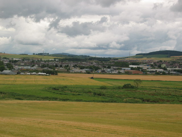
Inverurie is a town of 14,660 people in Scotland, United Kingdom.
Why visit Inverurie
Townapedia lists 11 museums and landmarks, 4 parks and trails, 26 places to eat, 6 places to stay and 3 attractions in and around town.
Highlights include Inveramsay Bridge, Easter Aquhorthies and Kirkton of Bourtie stone circle.
Weather in Inverurie
Forecast from MET Norway (CC BY 4.0). Full forecast
About Inverurie
Inverurie ( in-və-ROO-ree; Scottish Gaelic: Inbhir Uraidh or Inbhir Uaraidh, "mouth of the River Ury") is a market town in Aberdeenshire, Scotland at the confluence of the rivers Ury and Don, about 16 miles (26 km) north-west of Aberdeen. It had a population of 15,106 in 2022.
From the Wikipedia article Inverurie (this version), under CC BY-SA 4.0.
Travel tips from other travellers: Inverurie on Wikivoyage (CC BY-SA 4.0).
Things to do3

Inveramsay Bridge
Bridge · 3.0 mi
2016 bridge in Aberdeenshire, Scotland, UK, carries the A96 road across Aberdeen-Inverness railway line

Museums and landmarks11

Easter Aquhorthies
Monument and historic site · 2.6 mi
Well-preserved recumbent stone circle in north-east Scotland

Kirkton of Bourtie stone circle
Monument and historic site · 2.7 mi
Archaeological site in Aberdeenshire, Scotland, UK


Garioch Heritage Centre
Museum
Museum in Inverurie, Aberdeenshire, Scotland, UK
Loco Works Road, Inverurie

Balquhain stone circle
Monument and historic site · 2.8 mi
Stone circle in Aberdeenshire, Scotland, UK
Parks, trails and playgrounds4


Restaurants and cafes26


Asian Kitchen
Restaurant · Chinese
Constitution Street, Inverurie
Tu-Su 16:30-22:00


14 more on the map.
History
On a nearby hillside the Easter Aquhorthies stone circle dates back to the 3rd millennium BC. On the outskirts of the town the Brandsbutt Stone is a class I Pictish symbol stone with an ogham inscription.
The Bass of Inverurie is said to have been founded by David, Earl of Huntingdon, brother of Malcolm IV, in the late 12th century. However the religious foundation pre-dates this by five centuries with the establishment of the Kirk of Inverurie, now known as St Andrew's Parish Church.
The town's earliest known charter dates from 1558, and its modern development started after the building of the Aberdeenshire Canal linking Port Elphinstone with Aberdeen Harbour in 1806.
the Battle of Harlaw (1411) between Donald of Islay, Lord of the Isles (MacDonald) and an army commanded by Alexander Stewart, Earl of Mar; and
the Battle of Inverurie (1745) during the Jacobite rising of 1745.
The House of Aquahorthies is at Burnhervie on the edge of Inverurie, built around 1797. The house served as a clandestine major seminary until after Catholic Emancipation in 1829, and since then it has been a private family home.
During the Second World War, Luftwaffe planes would have been seen several times, during the Blitz against the nearby city of Aberdeen, but Inverurie itself was not bombed.
Read more of the history
The Inverurie Locomotive Works, which closed in 1969, led to a modest increase in size and prosperity, but much of the growth came from the "Oil boom" in 1970s.
International Paper had a paper mill at Thainstone, which closed in March 2009.
From the History section of Inverurie on Wikipedia, under CC BY-SA 4.0.
More about Inverurie
Geography
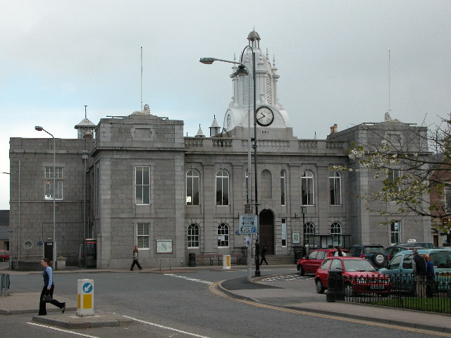
Inverurie is in the strath of the River Don at the centre of Aberdeenshire and is known locally as the Heart of the Garioch. It sits between the River Don and the River Ury and is 10 miles (16 km) from the imposing hill of Bennachie. The town centre is triangular and is dominated by Inverurie Town Hall built in 1863. In the middle of the 'square' (as it is known locally) is the Inverurie and District War Memorial, capped by a lone Gordon Highlander looking out over the town. The main shopping areas include the Market Place and West High Street which branches off from the centre towards the more residential part of the town. South of the River Don is the village of Port Elphinstone, which is part of the Royal Burgh of Inverurie and is so called due to the proximity of the former Aberdeenshire Canal which ran from Inverurie to Aberdeen.
From the Wikipedia article Inverurie, under CC BY-SA 4.0.
Notable people from Inverurie
 Robert LyonCanadian duellist (1812–1833)Photo: Alan L. Brown, Attribution
 Evan Duthiemusical artistPhoto: Madwife18, CC BY-SA 4.0
- Peter NicolBritish squash player
- Alan Ewen DonaldBritish diplomat (1931-2018)
- Mark McDonaldScottish politician (born 1980)
- Darren MackieScottish professional football player (born 1982)
- Ethan RossScottish footballer
- Arthur Keith-Falconer, 10th Earl of KintoreBritish peer
- Sandy MutchScottish footballer (1884-1967)
- Stuart Corsarrugby player
Born in Inverurie, according to Wikidata (CC0). Each name links to its Wikipedia article.
Where to stay6
Churches and places of worship6
Inverurie West Parish Church
Church · Church Of Scotland
West High Street, Inverurie
The Church of the Immaculate Conception
Church · Roman Catholic · 0.5 mi
North Street, Inverurie
Shopping13
Gas and EV charging2
Schools, colleges and libraries7
North East Scotland College - Inverurie Learning Centre
School
West Church Lane, Inverurie
Healthcare4
Map of Inverurie
82 places. The map loads OpenStreetMap tiles when you open it.
Getting there and nearby towns
Aberdeen International Airport (ABZ) is the nearest airport with scheduled flights listed in OpenStreetMap, 9 miles away.
- Kintore 3 mi south, about 6 min by car
- Oldmeldrum 4 mi northeast, about 7 min by car
- Kemnay 4 mi southwest, about 7 min by car
- Blackburn 6 mi southeast, about 10 min by car
- Newmacher 7 mi east, about 12 min by car
- Pitmedden 8 mi northeast, about 13 min by car
- Aberdeen 14 mi southeast, about 23 min by car
- Stonehaven 23 mi south, about 37 min by car
- Peterhead 27 mi northeast, about 43 min by car
- Montrose 39 mi south, about 1 h by car
Drive times are estimates from straight-line distance, not routes.
Towns near Inverurie


Keep exploring
Local news
Headlines from INDB.
Reviews, tips and questions
Loading what members have shared...
Sources and licences
- GeoNames (CC BY 4.0): population, coordinates, regions and time zone
- OpenStreetMap contributors (ODbL 1.0): places, airports, map data
- Wikidata (CC0 1.0): elevation, founding date, time zone, website, landmarks and historic places
- Wikimedia Commons (see each image): photos
- Wikipedia (CC BY-SA 4.0): overview and history text
Photo credits
- Inverurie-Panorama, Lizzie, CC BY-SA 2.0
- Inverurie Town Hall, John Aldersey-Williams, CC BY-SA 2.0
- Inveramsay Bridge Construction, Polar020202, CC BY-SA 4.0
- Easter Aquhorthies Stone Circle 01, Otter, CC BY-SA 3.0
- Kirkton of Bourtie stone circle, stu smith from Hampton Wick / Aberdeen, uk, CC BY-SA 2.0
- Bourtie Church, side angle, Sagaciousphil, CC BY-SA 3.0
- Inverurie Academy, TheBankser, CC BY-SA 4.0
- Brandsbutt Symbol Stone, Inverurie (48852482018), Tom Parnell from Scottish Borders, Scotland, CC BY-SA 2.0

Page built November 10, 2026. Spotted a mistake? Tell us or suggest a place.