


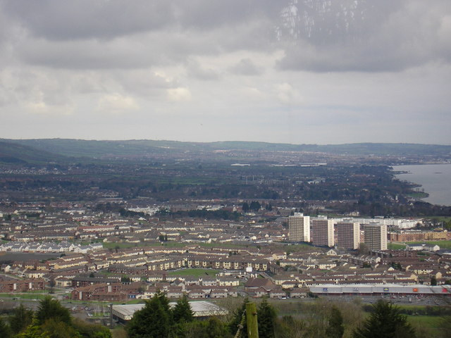


Newtownabbey, United Kingdom
Newtownabbey is a town of 63,860 people in Northern Ireland, United Kingdom.
Why visit Newtownabbey
Townapedia lists 34 museums and landmarks, 17 parks and trails, 64 places to eat, 2 places to stay and 2 attractions in and around town.
Highlights include Belfast Zoo, Aluminum Christmas tree, Stephen Boyd and Alexandra Park, Belfast.
Weather in Newtownabbey
Forecast from MET Norway (CC BY 4.0). Full forecast
About Newtownabbey
Newtownabbey is a large settlement north of Belfast city centre in County Antrim, Northern Ireland. It is separated from the rest of the city by Cavehill and Fortwilliam golf course, but it still forms part of the Belfast metropolitan area. It surrounds Carnmoney Hill, and was formed from the merging of several small villages including Whiteabbey, Glengormley and Carnmoney. At the 2021 census, Metropolitan Newtownabbey Settlement had a population of 67,599, making it the third largest settlement in Northern Ireland and seventh on the Island of Ireland.
From the Wikipedia article Newtownabbey (this version), under CC BY-SA 4.0.
Travel tips from other travellers: Newtownabbey on Wikivoyage (CC BY-SA 4.0).
Photos of Newtownabbey

Things to do2

Belfast Zoo
Zoo and aquarium · 1.4 mi
Zoo in Northern Ireland
Antrim Road, Belfast
Mar 21-Sep 30 10:00-20:00; Oct 01-Mar 20 10:00-16:00

Museums and landmarks34




B-17 WWII Crash Memorial
Monument and historic site · 1.5 mi
A memorial to the ten crew members of a B-17 which crashed into Cave Hill on the 1st June 1944 when flying through cloud while...
22 more on the map.
Parks, trails and playgrounds17




King's Coronation Garden
Park · 0.4 mi
Located in the beautiful setting of Hazelbank Park, The Coronation Garden has been designed by award-winning gardener Diarmuid Gavin and...
Bawnmore Memorial Garden
Park · 0.8 mi
Medium-sized memorial garden enclosed with a wall, railings, and gates. Contains an inscribed rock, two plaques attached to one wall,...

5 more on the map.
Restaurants and cafes64

Bureau by the Lough
Restaurant · Seafood, Steak House, Grill · 1.4 mi
637 Shore Road, Whiteabbey
Mo-Tu 10:00-22:00; We-Th 10:00-23:00; Fr-Sa 10:00-00:00; Su 11:00-22:00


52 more on the map.
History
Newtownabbey Urban District was founded on 1 April 1958 to cover seven villages north of Belfast: Carnmoney, Glengormley, Jordanstown, Monkstown, Whiteabbey, Whitehouse and Whitewell. Before this, the area fell under the jurisdiction of Belfast Rural District.
Newtownabbey Urban District Council was succeeded by Newtownabbey District Council (1973–1977), Newtownabbey Borough Council (1977–2015), and Antrim and Newtownabbey District Council (2015 onwards).
During The Troubles, there were a number of incidents in Newtownabbey, including several gun attacks involving the UFF and UVF.
From the History section of Newtownabbey on Wikipedia, under CC BY-SA 4.0.
More about Newtownabbey
Geography
Newtownabbey is a large dispersed urban area north of Belfast, surrounding Carnmoney Hill. To its east is Belfast Lough, and to its south and west is Cavehill. There are two wooded river glens running through it: the Three Mile Water and the Glas-na-Bradan.
Below is a list of townlands that are within Newtownabbey's urban area, alongside their likely etymologies.
Ballybought (from Irish Baile Bocht, meaning 'poor townland')*
Ballyduff (from Baile Mhic Giolla Dhuibh, "MacElduff's townland")*
Ballygolan (from Baile an Ghabhláin, "townland of the fork")*
Ballyvesey (possibly from Baile an Mheasa, "townland of the mast)*
Ballywonard (from Baile an Mhuine Aird, "townland of the high thicket")*
Collinward (formerly Ballygorinward, possibly from Baile Gorán Bhaird, "townland of the bard's grove")*
Croghfern (formerly Curraghfarny, possibly from Currach Fearnaí, "marsh of the place of alders")*
Drumnadrough (from Droim na gCruach, "ridge of the stacks")*, site of Merville Garden Village
Whitehouse (named after a 16th-century fortified house built by an English adventurer; formerly Ballyrintollard)*
Mossley (named after Mossley, England; in Ballyhenry townland)
Whitewell (named after a former spring; in Ballygolan townland)
From the Wikipedia article Newtownabbey, under CC BY-SA 4.0.
Notable people from Newtownabbey
 Kofi BalmerNorthern Irish footballerPhoto: EchetusXe, CC BY-SA 4.0
- Leah McFallBritish singer and songwriter
- Bernadette Sands McKevittNorthern Irish activist (born 1958)
- Joe Duboisassociation football player (1927-1987)
- Joe EnglishNorthern Irish politician

Born in Newtownabbey, according to Wikidata (CC0). Each name links to its Wikipedia article.
Where to stay2
Churches and places of worship26
Kingdom Hall of Jehovah's Witnesses
Church · Jehovahs Witness · 1.4 mi
319 Whitewell Road, Newtownabbey
Church of the Holy Evangelists
Church · Anglican · 1.6 mi
Church Road, Newtownabbey
Abbots Cross Congregational Church
Church · Congregational · 0.6 mi
Doagh Road, Newtownabbey
Abbots Cross Presbyterian Church
Church · Presbyterian · 0.7 mi
Abbots Road, Newtownabbey
Calvary Pentecostal Church
Church · Pentecostal · 0.7 mi
Doagh Road, Newtownabbey
Shopping20
Gas and EV charging6
Schools, colleges and libraries12
St James's Primary School and Nursery Unit
School · Roman Catholic · 1.2 mi
17 Kings Walk, Newtownabbey
St Mary's Star of the Sea Primary School
School · Roman Catholic · 1.4 mi
730-760 Shore Road, Belfast
Our Lady of Lourdes Primary School
School · Roman Catholic · 1.5 mi
700 Antrim Road, Belfast
Healthcare12
Map of Newtownabbey
195 places. The map loads OpenStreetMap tiles when you open it.
Getting there and nearby towns
George Best Belfast City Airport (BHD) is the nearest airport with scheduled flights listed in OpenStreetMap, 3 miles away.
- Jordanstown 2 mi north, about 3 min by car
- Carnmoney 2 mi northwest, about 4 min by car
- Greenisland 3 mi northeast, about 5 min by car
- Belfast 4 mi south, about 7 min by car
- Holywood 4 mi southeast, about 6 min by car
- Carrickfergus 6 mi northeast, about 9 min by car
- Castlereagh 6 mi south, about 10 min by car
- Dundonald 6 mi southeast, about 10 min by car
- Ballyclare 7 mi northwest, about 12 min by car
- Portadown 27 mi southwest, about 43 min by car
Drive times are estimates from straight-line distance, not routes.
Keep exploring
Local news
Headlines from INDB.
Reviews, tips and questions
Loading what members have shared...
Sources and licences
- GeoNames (CC BY 4.0): population, coordinates, regions and time zone
- Mapillary (see each image): photos
- OpenStreetMap contributors (ODbL 1.0): places, airports, map data
- Wikidata (CC0 1.0): elevation, founding date, time zone, website, landmarks and historic places
- Wikimedia Commons (see each image): photos
- Wikipedia (CC BY-SA 4.0): overview and history text
Photo credits
- Belfast Zoo White Tiger, Quichot, Public domain
- Alexandra Park - the 'Catholic' side - panoramio, Keith Ruffles, CC BY 3.0
- Rathcoole - Newtownabbey, John Pollock, CC BY-SA 2.0
- Jehovah's Witnesses outside the British Museum 02, Philafrenzy, CC BY-SA 4.0
- Stephen Boyd, Hugo van Gelderen / Anefo, CC BY-SA 3.0 nl
- Armagh Cathedral (Church of Ireland), JohnArmagh (shifted & cropped by Rabanus Flavus ), CC BY-SA 4.0
- McCaughey House, Whiteabbey Hospital, Mckyj, CC BY-SA 4.0
- Grandma - 358599174, Paddy McCann, CC BY 2.0
- Street-level photo, laye, CC BY-SA 4.0
- Street-level photo, laye, CC BY-SA 4.0
- Street-level photo, laye, CC BY-SA 4.0
- Street-level photo, laye, CC BY-SA 4.0
- Street-level photo, yannakis, CC BY-SA 4.0

Page built November 10, 2026. Spotted a mistake? Tell us or suggest a place.