
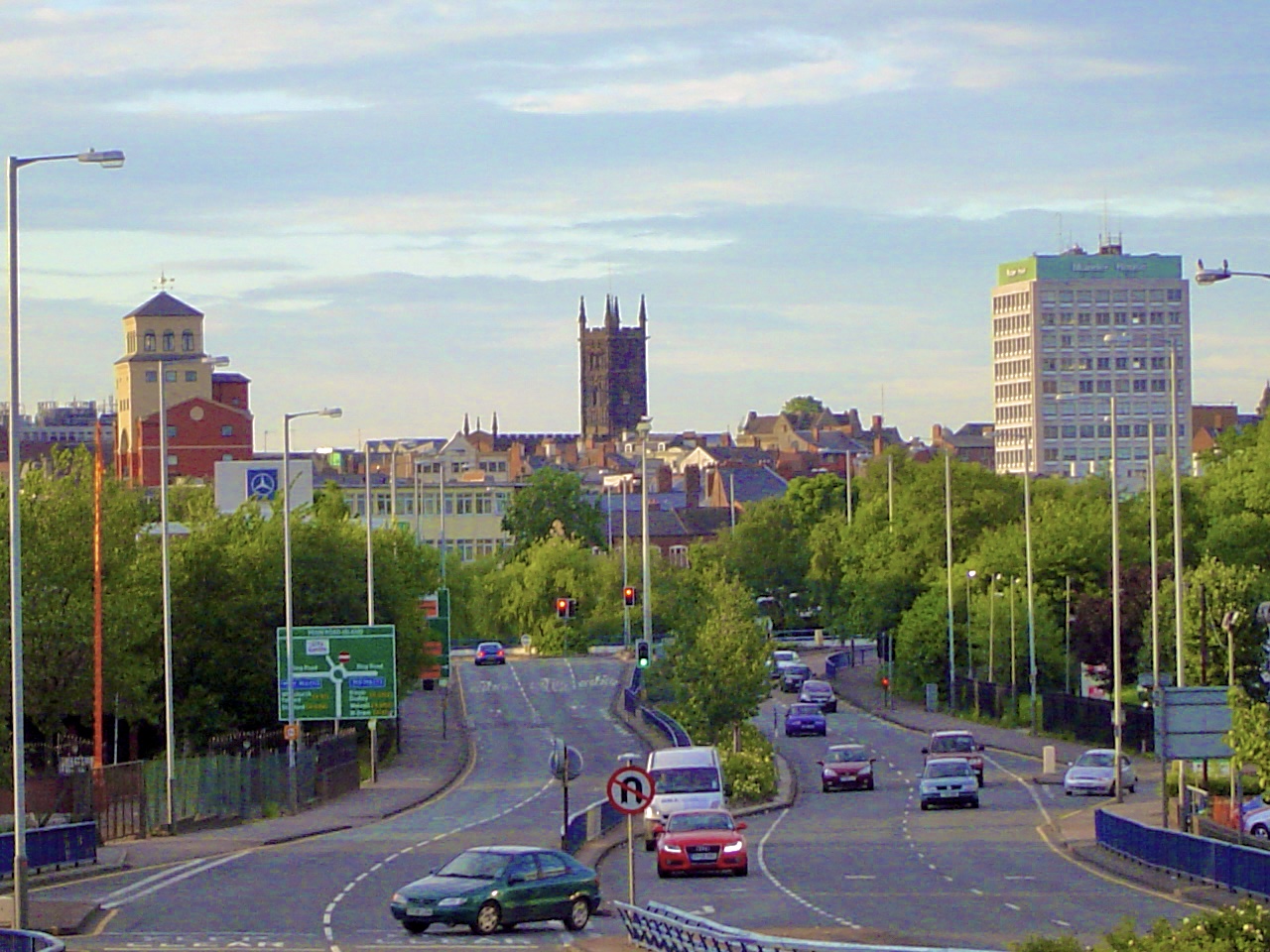


Wolverhampton, United Kingdom
Wolverhampton is a city of 263,700 people in England, United Kingdom, founded in 985.
Why visit Wolverhampton
Townapedia lists 92 museums and landmarks, 87 parks and trails, 142 places to eat, 20 places to stay and 17 attractions in and around town.
Highlights include Grand Theatre, Arena Theatre, Moseley Old Hall and Wolverhampton Art Gallery.
Weather in Wolverhampton
Forecast from MET Norway (CC BY 4.0). Full forecast
About Wolverhampton
Wolverhampton is a city and metropolitan borough, in the West Midlands, England. Located around 12 miles (19 km) north-west of Birmingham, it forms the north-western part of the West Midlands conurbation, with the towns of Willenhall and Walsall to the east, and the towns of Sedgley and Dudley to the south. The population in 2021 was 263,700, making it the third largest city in the county after Birmingham and Coventry.
From the Wikipedia article Wolverhampton (this version), under CC BY-SA 4.0.
Travel tips from other travellers: Wolverhampton on Wikivoyage (CC BY-SA 4.0).
Photos of Wolverhampton


Things to do17

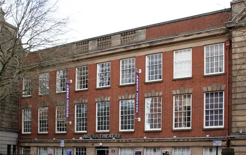
Arena Theatre
Cinema and theater
University theatre in Wolverhampton, England

Dudley Hippodrome
Cinema and theater · 5.3 mi
Former theatre in Dudley, England, later used as a bingo hall


Opera House
Cinema and theater · 5.3 mi
Former theatre in Dudley, England (1899-1936)

5 more on the map.
Museums and landmarks92

Moseley Old Hall
Monument and historic site · 3.7 mi
Historic house and museum in Featherstone, Staffordshire, England, UK
Moseley Old Hall Lane, Fordhouses

Wolverhampton Art Gallery
Museum
Art gallery in West Midlands, United Kingdom
Litchfield Street, Wolverhampton
Mo-Sa 10:30-16:30; Su 11:00-16:00

Wightwick Manor
Monument and historic site · 3.0 mi
Grade I listed historic house museum in the West Midlands, UK


Coal Barque 'Surprise'
Monument and historic site · 4.3 mi
One of four stones excavated from Bentley Hall, surrounding Bentley Cairn, tells the story of King Charles II sheltering here after...

Monarch on the Run
Monument and historic site · 4.3 mi
One of four stones excavated from Bentley Hall, surrounding Bentley Cairn, tells the story of King Charles II sheltering here after...

The Royal Crown
Monument and historic site · 4.3 mi
One of four stones excavated from Bentley Hall, surrounding Bentley Cairn, tells the story of King Charles II sheltering here after...

The Royal Oak
Monument and historic site · 4.3 mi
One of four stones excavated from Bentley Hall, surrounding Bentley Cairn, tells the story of King Charles II sheltering here after...

Wolverhampton Pillar
Monument and historic site
Shaft of an Anglo-Saxon High cross, still standing in its original location in the churchyard of St Peter's Collegiate Church, in...

Bilston Craft Gallery
Museum · 2.5 mi
Museum and library in Bilston, Wolverhampton

Black Country Living Museum
Museum · 4.8 mi
Open-air museum of manufacturing history in Dudley, West Midlands, England, United Kingdom

Chillington Hall
Museum · 6.1 mi
Grade I listed historic house museum in South Staffordshire, England, UK
80 more on the map.
Parks, trails and playgrounds87


Baggeridge Country Park
Park · 3.8 mi
Country park in Staffordshire, England
East Park
Park · 1.1 mi
Park in Wolverhampton, West Midlands, England, UK
West Park
Park · 0.8 mi
Park in Wolverhampton, West Midlands, England, UK
Bantock House Museum
Park · 1.4 mi
Museum and surrounding parkland in Wolverhampton, England
Barrow Hill Local Nature Reserve
Park · 5.5 mi
Park in Pensnett, Dudley, West Midlands, England
Brunswick Park
Park · 5.2 mi
Public park in Wednesbury, West Midlands, England, UK

75 more on the map.
Restaurants and cafes142




Costa
Cafe · Coffee Shop · 2.3 mi
Spring Road, Wolverhampton
Mo-Fr 06:00-20:00; Sa 06:00-19:00; Su 08:00-18:00


The Orange Tree
Restaurant · Indian · 1.7 mi
Reopened as Desi Bar and Grill
Ward Street, Ettingshall
Mo-Fr 15:00-22:30, Sa-Su 13:00-22:30
130 more on the map.
History
A local tradition states that King Wulfhere of Mercia founded an abbey of St Mary at Wolverhampton in 659.
Wolverhampton is recorded as being the site of a decisive battle between the unified Mercian Angles and West Saxons against the raiding Danes in 910, although sources are unclear as to whether the battle itself took place in Wednesfield or Tettenhall. Both places have since been incorporated into Wolverhampton. The Mercians and West Saxons claimed a decisive victory, and the field of Woden is recognised by numerous place names in Wednesfield.
In 985, King Ethelred the Unready granted lands at a place referred to as Heantun to Lady Wulfrun by royal charter, and hence founding the settlement.
St Mary's Church was founded in 966, later named St Peters. It is not known if The Wolverhampton Pillar predates that, but probably does. The Pillar is thought to be a Roman column taken from Wroxeter or Wall (Letocetum). In 994, a monastery was consecrated there in Wolverhampton for which Wulfrun granted land at Upper Arley in Worcestershire, Bilston, Willenhall, Wednesfield, Pelsall, Ogley Hay near Brownhills, Hilton near Wall, Hatherton, Kinvaston, Hilton near Wolverhampton and Featherstone. This became the site for the current St. Peter's Church. A statue of Lady Wulfrun, sculpted by Sir Charles Wheeler, can be seen on the stairs outside the church.
Read more of the history
Wolverhampton is recorded in the Domesday Book in 1086 as being in the Hundred of Seisdon and the county of Staffordshire. The lords of the manor are listed as the canons of St Mary, with the tenant-in-chief being Samson, William the Conqueror's personal chaplain. Wolverhampton at this date is a large settlement of fifty households.
In 1179, there is mention of a market held in the town, and, in 1204, it had come to the attention of King John that the town did not possess a Royal Charter for holding a market. This charter for a weekly market held on a Wednesday was eventually granted on 4 February 1258 by Henry III.
It is held that in the 14th and 15th centuries that Wolverhampton was one of the "staple towns" of the woollen trade, which can be seen today by the inclusion of a woolpack on the city's coat of arms, and by the many small streets, especially in the city centre, called "Fold", as well as Woolpack Street and Woolpack Alley.
In 1512, Sir Stephen Jenyns, a former Lord Mayor of London and a twice Master of the Worshipful Company of Merchant Taylors, who was born in the city, founded Wolverhampton Grammar School, one of the oldest active schools in Britain.
From the 16th century onwards, Wolverhampton became home to a number of metal industries, including lock and key making, and iron and brass working.
Wolverhampton suffered two great fires: the first in April 1590 and the second in September 1696. Both fires started in today's Salop Street. The first fire lasted for five days and left nearly 700 people homeless, whilst the second destroyed 60 homes in the first five hours. This second fire led to the purchase of the first fire engine within the city in September 1703.
On 27 January 1606, two farmers, Thomas Smart and John Holyhead of Rowley Regis, were executed on High Green, now Queen Square, for sheltering two of the Gunpowder Plotters, Robert Wintour and Stephen Littleton, who had fled to the Midlands. The pair played no part in the original plot nevertheless suffered a traitor's death of being hanged, drawn and quartered on butcher's blocks set up in the square a few days before the execution of Guy Fawkes and several other plotters in London.
There is evidence that Wolverhampton may have been the location of the first working Newcomen Steam Engine in 1712.
A few years before she began her reign, Queen Victoria visited Wolverhampton in the 1830s and described it as "a large and dirty town", but one that received her "with great friendliness and pleasure." In Victorian times, Wolverhampton grew to be a wealthy town mainly due to the huge amount of industry that occurred as a result of the abundance of coal and iron deposits in the area. The remains of this wealth can be seen in local houses such as Wightwick Manor and The Mount (both built for the prominent varnish and paint manufacturers, the Mander family) as well as Tettenhall Towers. All three are located in the western fringe of Wolverhampton, in the areas known as Wightwick and Tettenhall. Many other houses of similar stature were demolished in the 1960s and 1970s.
Wolverhampton gained its first parliamentary representation as part of the Reform Act 1832, when it was one of 22 large towns that were allocated two members of Parliament. A local mob attacking electors who voted or intended to vote for the Tory candidate led to the 1835 Wolverhampton riot, with dragoons being called in to end the intimidation. Wolverhampton was incorporated as a municipal borough on 15 March 1848, under the Municipal Corporations Act 1835, before becoming a county borough in 1889. It was represented politically in Victorian times by Charles Pelham Villiers, a Liberal MP and noted free trade supporter who was also the longest-serving MP in parliamentary history. Lord Wolverhampton, Henry Hartley Fowler was MP for Wolverhampton at the turn of the century.
The railways reached Wolverhampton in 1837, with the first station located at Wednesfield Heath, now Heath Town, on the Grand Junction Railway. This station was demolished in 1965, but the area exists as a nature reserve just off Powell Street.
Wolverhampton railway works was established in 1849 for the Shrewsbury and Birmingham Railway and became the Northern Division workshop of the Great Western Railway in 1854.
From the History section of Wolverhampton on Wikipedia, under CC BY-SA 4.0.
More about Wolverhampton
Geography
Wolverhampton lies 13 miles (21 km) north-west of its larger near-neighbour Birmingham and forms the second largest part of the West Midlands conurbation. To the north and west lies the Staffordshire and Shropshire countryside.
Wolverhampton city centre falls outside of the area traditionally known as the Black Country, although some areas such as the town and former borough of Bilston and Heath Town, and the Willenhall side of Wolverhampton, fall within the Black Country coalfields, leading to confusion as to whether the entire city falls within the region. Modern usage has tended towards using the term to refer to the western part of the West Midlands, excluding Birmingham, Solihull and Coventry. Examples would be UK Government regional bodies such as the Black Country Development Corporation, under whose remit the city fell.
The city lies upon the Midlands Plateau at 163 metres (535 ft) above sea level. There are no major rivers within the city, although the rivers Penk and Tame rise in the city, as does Smestow Brook, a tributary of the Stour, and thence the Severn. This means that the city lies astride the main east–west watershed of England.
The geology of the city is complex, with a combination of Triassic and Carboniferous geology; specifically Bunter and Keuper sandstone, and Upper and Middle Coal measures. There is an area of dolerite intrusions.
Economy
Traditionally, Wolverhampton's economy was dominated by iron, steel, automobiles, engineering and manufacturing industries. Many traditional industries in the city closed or dramatically downsized over the years. By 2008 the economy was dominated by the service sector, at 74.9% of the city's employment. The major parts are public administration, education and health (32.8% of total employment), distribution, hotels and restaurants (21.1%), and finance and IT (12.7%). The largest non-service industry was manufacturing (12.9%), and 5.2% of total employment related to tourism.
The largest single employer within the city is Wolverhampton City Council. which has over 12,000 staff Other large employers within the city include:
Education: University of Wolverhampton and City of Wolverhampton College
Construction: Carillion (headquarters), entered liquidation January 2018
Retail: Beatties (bought by House of Fraser 2005, closed 2019)
Manufacturing: Chubb Locks, Jaguar Land Rover (Engine Assembly Plant)
Arts and culture
The rock groups Slade, Cloven Hoof, Sahotas, The Mighty Lemon Drops and Babylon Zoo came from Wolverhampton, as did electronic musician Bibio, soul/R&B singer Beverley Knight, drum and bass guru Goldie, and roots reggae maestro Macka B. Kevin Rowland of Dexys Midnight Runners was born in Wednesfield, Wolverhampton.
Hip hop music producer S-X, who has worked with T.I., J. Cole, Birdman and Lil Wayne, was born and raised and still lives in Wolverhampton. In 2010, Wolverhampton-born singer Liam Payne (1993–2024) came third in the British television music show The X Factor with his boy band One Direction, who in March 2012 became the first British group to go straight to the top of the US music charts with their debut album, Up All Night.
Education
The University of Wolverhampton is the main provider of higher education in the city. The university currently has more than 23,000 students. In 1835, the Wolverhampton Mechanics' Institute was founded, and its lineage can be traced via the Wolverhampton and Staffordshire Technical College (1935), to The Polytechnic, Wolverhampton (1969) to today's University of Wolverhampton, given university status in 1992. The main university campus is in the city centre, with other campuses at Compton, and in the nearby towns of Walsall and Telford.
Wolverhampton Grammar School was founded in 1512, making it one of the oldest active schools in the UK. Old boys include Mervyn King, Governor of the Bank of England between July 2003 and 2013, and Sir David Wright, former British Ambassador to Japan.
Other notably historic schools include The Royal School, Wolverhampton (founded in 1850), and Tettenhall College (1863), which educated the winner of Nobel Prize for Chemistry, Professor Sir Arthur Harden. City of Wolverhampton College is the main further education college in the city.
From the Wikipedia article Wolverhampton, under CC BY-SA 4.0.
Notable people from Wolverhampton
 Ashley WilliamsWelsh association football player (born 1984)Photo: Steindy ( talk ) 16:12, 10 November..., CC BY-SA 3.0
 Anya ChalotraBritish actressPhoto: Gage Skidmore, CC BY-SA 3.0
 Robert JenrickBritish politician (born 1982)Photo: ©House of Commons / photography by..., CC BY 3.0
 Dave HollandBritish jazz musicianPhoto: Dirk Neven, CC BY 2.0
 Jack TaylorEnglish association football referee (1930-2012)Photo: Nationaal Archief, Den Haag,..., CC BY-SA 3.0 nl
 Don HoweEnglish footballer and manager (1935-2015)Photo: Kroon, Ron for Anefo, CC BY-SA 3.0 nl
 William BaylissBritish physiologist (1860–1924)Photo: Unknown author Unknown author, CC BY 4.0
- Liam PayneEnglish singer-songwriter (1993–2024)
- Sam MorsyEgyptian association football player (born 1991)
- Catherine EddowesWhitechapel murder victim (1842-1888)
- Mark DaviesBritish footballer (born 1988)
- Evelyn UnderhillBritish mystic, poet, and novelist (1875–1941)


Born in Wolverhampton, according to Wikidata (CC0). Each name links to its Wikipedia article.
Where to stay20
Holiday Inn Wolverhampton - Racecourse
Motel and hotel · 1.5 mi
Dunstall Park, Wolverhampton
Churches and places of worship73
Church of All Saints
Church · Anglican · 4.2 mi
Walsall Road, Walsall
Shopping68
Gas and EV charging33
Schools, colleges and libraries38
Our Lady and St Chad Catholic Academy
School · Roman Catholic · 1.9 mi
Old Fallings Lane, Wolverhampton
Healthcare35
Map of Wolverhampton
250 places. The map loads OpenStreetMap tiles when you open it.
Getting there and nearby towns
Birmingham Airport (BHX) is the nearest airport with scheduled flights listed in OpenStreetMap, 18 miles away.
- Wednesfield 2 mi northeast, about 3 min by car
- Bilston 2 mi southeast, about 4 min by car
- Willenhall 3 mi east, about 4 min by car
- Featherstone 4 mi north, about 7 min by car
- Essington 4 mi northeast, about 7 min by car
- Wombourne 4 mi southwest, about 7 min by car
- Tipton 5 mi southeast, about 7 min by car
- Codsall 5 mi northwest, about 7 min by car
- Birmingham 12 mi southeast, about 19 min by car
- Worcester 28 mi south, about 45 min by car
Drive times are estimates from straight-line distance, not routes.
Keep exploring
Local news
Headlines from INDB.
Reviews, tips and questions
Loading what members have shared...
Sources and licences
- GeoNames (CC BY 4.0): population, coordinates, regions and time zone
- Mapillary (see each image): photos
- OpenStreetMap contributors (ODbL 1.0): places, airports, map data
- Openverse (see each image): photos
- Wikidata (CC0 1.0): elevation, founding date, time zone, website, landmarks and historic places
- Wikimedia Commons (see each image): photos
- Wikipedia (CC BY-SA 4.0): overview and history text
Photo credits
- Wolverhampton, Statsfan, CC BY-SA 3.0
- Wolverhampton Bus Station (16568602720), Elliott Brown from Birmingham, United Kingdom, CC BY-SA 2.0
- Wolverhampton Bus Station (16548733307), Elliott Brown from Birmingham, United Kingdom, CC BY-SA 2.0
- Wolverhampton Bus Station (16730110366), Elliott Brown from Birmingham, United Kingdom, CC BY-SA 2.0
- Wolverhampton Bus Station (16568417978), Elliott Brown from Birmingham, United Kingdom, CC BY-SA 2.0
- Hippodrome, LivingInMediocrity, CC BY-SA 3.0
- Moseley Old Hall 2015 003, Photograph by Mike Peel ( www.mikepeel.net )., CC BY-SA 4.0
- Wolverhampton Art Gallery, Æthelred, CC BY-SA 3.0
- Wightwick Manor 2016 139, Photograph by Mike Peel ( www.mikepeel.net )., CC BY-SA 4.0
- Wolverhampton Saxon Pillar St Peter's Gardens, Brianboru100, CC BY-SA 4.0
- Blackcountrystreet, Jack1956, Public domain
- Chillington Hall (2), Philip Halling, CC BY-SA 2.0
- Dudley Zoo entrance, pic 2, England, Brian Clift, CC BY-SA 2.0
- Charles II of England in Coronation robes, John Michael Wright, Public domain
- Boscobel - Royal Oak 2011, Sjwells53, CC BY-SA 3.0
- New Cross Hospital Heart and Lung Centre, Brezelsuppe, CC BY-SA 3.0
- The Royal Escape Close-Hauled in a Breeze, Willem van de Velde the Younger, Public domain
- Wolverhampton City Archives, Brianboru100, CC BY-SA 4.0
- Church of St Mary Oxford Street Bilston, Brianboru100, CC BY-SA 3.0
- Holy Trinity Church Heath Town, John Goldring, CC BY-SA 3.0
- St Lawrence Church, KelliW592, CC BY-SA 4.0
- St Michael and All Angels Church, Tettenhall, Æthelred, CC BY-SA 3.0
- Wolverhampton St Jude's Tettenhall Road, Brianboru100, CC BY-SA 4.0
- Edward Hyde, 1st Earl of Clarendon (copy after an original of c.1648–1655) title QS:P1476,en:"Edward Hyde, 1st Earl of Clarendon (copy after an original of c.1648–1655) " label QS:Len,"Edward Hyde..., Adriaen Hanneman (died 1671), Public domain
- Mapillary (197412202205423, esHO FMQTECrGWPgrXHGlg) (edloach) 2018-12-28 12H38M27S000, edloach, CC BY-SA 4.0
- Mapillary (543889586747159, esHO FMQTECrGWPgrXHGlg) (edloach) 2018-12-28 12H38M28S000, edloach, CC BY-SA 4.0
- Mapillary (503804444153808, esHO FMQTECrGWPgrXHGlg) (edloach) 2018-12-28 12H38M26S000, edloach, CC BY-SA 4.0
- Mapillary (283285253502680, esHO FMQTECrGWPgrXHGlg) (edloach) 2018-12-28 12H38M29S000, edloach, CC BY-SA 4.0
- Mapillary (2048685168641122, esHO FMQTECrGWPgrXHGlg) (edloach) 2018-12-28 12H38M24S000, edloach, CC BY-SA 4.0
- Mapillary (924072728133415, esHO FMQTECrGWPgrXHGlg) (edloach) 2018-12-28 12H38M30S000, edloach, CC BY-SA 4.0
- Mapillary (164264932295354, esHO FMQTECrGWPgrXHGlg) (edloach) 2018-12-28 12H38M23S000, edloach, CC BY-SA 4.0
- Grand Theatre Wolverhampton, Andrew W Kerr, CC BY-SA 4.0
- Ian Parker at the Robin 2 (4194403657), Tony Hisgett from Birmingham, UK, CC BY 2.0
- Bilston Craft Gallery and Library - Mount Pleasant, Bilston (27903837899), Elliott Brown from Birmingham, United Kingdom, CC BY-SA 2.0
- Arena Theatre Wolverhampton, ahisgett, CC BY 2.0
- Street-level photo, adam2, CC BY-SA 4.0
- Street-level photo, edloach, CC BY-SA 4.0
- Street-level photo, edloach, CC BY-SA 4.0
- Street-level photo, tallguy, CC BY-SA 4.0
- Street-level photo, edloach, CC BY-SA 4.0
- Street-level photo, southglos, CC BY-SA 4.0
- Street-level photo, southglos, CC BY-SA 4.0
- Street-level photo, adam2, CC BY-SA 4.0
- Street-level photo, adam2, CC BY-SA 4.0
- Street-level photo, adam2, CC BY-SA 4.0
- Street-level photo, edloach, CC BY-SA 4.0
- Street-level photo, tallguy, CC BY-SA 4.0
- Street-level photo, edloach, CC BY-SA 4.0
- Street-level photo, southglos, CC BY-SA 4.0
- Street-level photo, edloach, CC BY-SA 4.0
- Street-level photo, adam2, CC BY-SA 4.0


Page built November 10, 2026. Spotted a mistake? Tell us or suggest a place.