


Golden Valley, Minnesota
Golden Valley is a city of 21,725 people in Hennepin County, Minnesota, founded in 1886.
Why visit Golden Valley
Townapedia lists 76 museums and landmarks, 141 parks and trails, 108 places to eat, 9 places to stay and 13 attractions in and around town.
Highlights include Emagine Willow Creek, Interlachen Bridge, Farmers and Mechanics Savings Bank and Abbott Hospital.
July is the warmest month, with average highs of 82°F; January lows average 7°F, and about 54 inches of snow fall in a normal year.
Weather in Golden Valley
Forecast from the National Weather Service. Full forecast
About Golden Valley
Golden Valley is a western first-ring suburb of Minneapolis in Hennepin County, Minnesota, United States. Its population was 22,552 at the 2020 census, and was estimated to be 21,263 in 2024. The city is mostly residential and is bordered by Interstate 394. Over 15% of it is parks or nature reserves.
From the Wikipedia article Golden Valley, Minnesota (this version), under CC BY-SA 4.0.
Things to do13


Interlachen Bridge
Bridge · National Register of Historic Places · 4.7 mi
Bridge in Minneapolis, Minnesota, United States of America
Orpheum Theatre
Cinema and theater · National Register of Historic Places · 4.1 mi
Theater in Minneapolis, Minnesota
Broadway Avenue Bridge
Bridge · 4.1 mi
Bridge in Minneapolis, Minnesota
Bryant-Lake Bowl
Cinema and theater · 4.4 mi
Bowling alley, restaurant, bar, and theatre in Minnesota
Camden Bridge
Bridge · 4.7 mi
Bridge in Minneapolis, Minnesota, United States
Canadian Pacific Camden Place Rail Bridge
Bridge · 4.7 mi
Bridge in Minneapolis, Minnesota

Dunwoody College of Technology
School · 3.6 mi
Private technology school in Minneapolis, Minnesota
Northern Pacific-BNSF Minneapolis Rail Bridge
Bridge · 4.2 mi
Bridge in Minneapolis, Minnesota
New Hope Cinema Grill
Cinema and theater · 1.7 mi
2749 Winnetka Avenue North, New Hope
Showplace ICON
Cinema and theater · 1.7 mi
1625 West End Boulevard, Saint Louis Park
1 more on the map.
Museums and landmarks76

Farmers and Mechanics Savings Bank
Monument and historic site · National Register of Historic Places · 4.5 mi
Building in Minneapolis, Minnesota

Abbott Hospital
Monument and historic site · National Register of Historic Places · 4.4 mi
Apartment building and former hospital in Minneapolis, Minnesota, USA
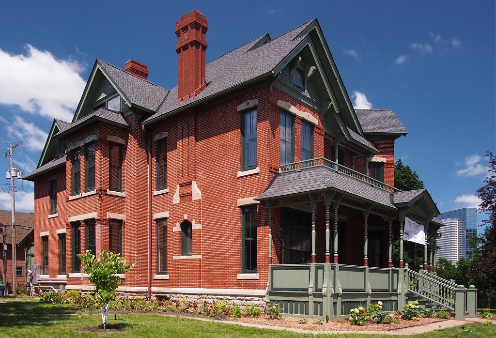
Amos B. Coe House
Monument and historic site · National Register of Historic Places · 4.5 mi
House in Minneapolis, Minnesota

Anne C. and Frank B. Semple House
Monument and historic site · National Register of Historic Places · 4.3 mi
Historic house in Minneapolis, Minnesota, United States

Architects and Engineers Building
Monument and historic site · National Register of Historic Places · 4.4 mi
Office building in downtown Minneapolis, Minnesota, United States

Basilica of Saint Mary
Monument and historic site · National Register of Historic Places · 3.7 mi
Roman Catholic minor basilica and co-cathedral in Minneapolis, Minnesota, USA
Butler Square
Monument and historic site · National Register of Historic Places · 4.2 mi
Office building in Minneapolis, Minnesota

Buzza Company Building
Monument and historic site · National Register of Historic Places · 4.3 mi
Building in Minneapolis, Minnesota, United States

Calhoun Beach Club
Monument and historic site · National Register of Historic Places · 3.5 mi
Historic building in Minnesota, United States of America
Charles J. Martin House
Monument and historic site · National Register of Historic Places · 3.4 mi
Historic house in Minnesota, United States


Chicago, Milwaukee, St. Paul and Pacific Depot
Monument and historic site · National Register of Historic Places · 3.7 mi
Railway station in St. Louis Park, the United States of America
Chicago, Milwaukee, St. Paul and Pacific Depot Freight House and Train Shed
Monument and historic site · National Register of Historic Places · 4.8 mi
Former train station in Minneapolis, Minnesota, since renovated for other uses
64 more on the map.
Parks, trails and playgrounds141


Cedar Lake East Beach
Beach · 2.8 mi
Beach in Minneapolis, Minnesota, United States
2000 Upton Avenue South, Minneapolis
Eloise Butler Wildflower Garden
Park · 2.1 mi
1 Theodore Wirth Parkway, Minneapolis
Apr 15-Oct 15: Tu-Su 07:30-18:00; Apr 15-Aug 31: Th 07:30-20:00;...

Breck School Anderson Ice Arena
Sports field and stadium · 1.3 mi
4210 Olson Memorial Highway, Golden Valley
129 more on the map.
Restaurants and cafes108

Bryn Mawr Pizza & Deli
Restaurant · Pizza · 2.7 mi
404 Cedar Lake Road South, Minneapolis
We-Mo 16:00-22:00
Crave
Restaurant · 1.7 mi
Bustling contemporary haungout featuring an eclectic mix of American fare & sushi.
1603 West End Blvd, St Louis Park, MN 55416
Mo-Th 11:00-22:00; Su 11:00-21:00; Fr, Sa 11:00-23:00
Green and the Grain
Restaurant · 1.7 mi
A quick service eatery serving premium salads + wraps, organic frozen yogurt and acai bowls.
1601 Utica Avenue South
Mo-Th 09:00-20:00; Fr 09:00-15:00; Sa 10:00-15:00
Little Szechuan Chinese Restaurant and Bar
Restaurant · Chinese · 1.6 mi
5377 16th Street West, Saint Louis Park
Mo-Th 11:00-22:00; Fr 11:00-23:00; Sa 11:30-23:00; Su 11:30-21:30
Nautical Bowls
Restaurant · 1.6 mi
Smoothie Bowls, dairy-free, plant-based, gluten-free
5327 West 16th Street
Mo-Su 09:00-19:00
Roti Modern Mediterranean
Restaurant · Mediterranean · 1.7 mi
1620 Park Place Boulevard, Saint Louis Park
Mo-Su 11:00-21:00
Samarkand Restaurant
Restaurant · Uzbek · 2.5 mi
16 Nathan Lane North
Su-Th 11:00-21:00; Fr 11:00-22:00; Sa 11:00-00:00
Song Tea & Poke
Restaurant · Poke, Tea, Milk Tea · 1.8 mi
1677 West End Boulevard, Saint Louis Park
Mo-Su 11:30-20:00
96 more on the map.
History
Golden Valley is located on the ancestral lands of the Dakota people. Ojibwe and Sioux tribes had encampments on nearby Medicine Lake. The first white settlers arrived in the early 1850s. Golden Valley was incorporated on December 17, 1886. In the early 20th century, it was mostly a farming community.
From the History section of Golden Valley, Minnesota on Wikipedia, under CC BY-SA 4.0.
Where to stay9
AC Hotel by Marriott Minneapolis West End
Motel and hotel · 1.6 mi
5075 Wayzata Boulevard, Saint Louis Park
DoubleTree by Hilton Hotel Minneapolis - Park Place
Motel and hotel · 1.5 mi
1500 Park Place Boulevard, Saint Louis Park
Churches and places of worship47
Church of Saint Stephen
Church · National Register of Historic Places · 4.7 mi
Gethsemane Episcopal Church
Church · National Register of Historic Places · 4.6 mi
Minneapolis Scottish Rite Temple
Church · National Register of Historic Places · 3.7 mi
Minneapolis Central Church-Christ
Church · Church Of Christ · 2.7 mi
1922 4th Avenue North, Minneapolis
Speak the Word Church International
Church · Pentecostal · 1.1 mi
515 Jersey Avenue South, Golden Valley
Shopping18
Shanghai Market
Grocery · Chinese · 2.2 mi
7105 Cedar Lake Road, Saint Louis Park
Gas and EV charging21
St. Louis Park Service
Gas station · 2.9 mi
7119 Minnetonka Boulevard, Saint Louis Park
Schools, colleges and libraries66
Benilde-St. Margaret's
School · Catholic · 2.4 mi
2501 Highway 100, Saint Louis Park
Healthcare15
North Memorial Health – Robbinsdale Hospital
Hospital · 2.4 mi
3300 Oakdale Avenue North, Robbinsdale
Park Nicollet Struthers Parkinson's Center
Clinic and pharmacy · 0.5 mi
6701 Country Club Drive, Golden Valley
Vanda Counseling and Psychological Services
Clinic and pharmacy · 0.9 mi
4969 Olson Memorial Highway, Golden Valley
DaVita Dialysis
Clinic and pharmacy · 1.6 mi
7525 Wayzata Boulevard, Saint Louis Park
Northpoint Health & Wellness Center
Clinic and pharmacy · 2.4 mi
1313 North Penn Avenue, Minneapolis
Robbinsdale Clinic P.A.
Clinic and pharmacy · 2.7 mi
3819 West Broadway Avenue, Robbinsdale
Map of Golden Valley
250 places. The map loads OpenStreetMap tiles when you open it.
Climate by month
Monthly table
| Month | High | Low | Rain | Snow |
|---|---|---|---|---|
| Jan | 24°F | 7°F | 0.9 in | 10.1 in |
| Feb | 29°F | 11°F | 1.0 in | 10.1 in |
| Mar | 42°F | 23°F | 1.9 in | 9.0 in |
| Apr | 57°F | 35°F | 3.3 in | 5.1 in |
| May | 69°F | 48°F | 4.5 in | 0.0 in |
| Jun | 78°F | 58°F | 4.6 in | 0.0 in |
| Jul | 82°F | 63°F | 4.5 in | 0.0 in |
| Aug | 80°F | 61°F | 4.2 in | 0.0 in |
| Sep | 72°F | 52°F | 3.5 in | 0.0 in |
| Oct | 57°F | 39°F | 3.0 in | 0.8 in |
| Nov | 41°F | 26°F | 1.9 in | 6.9 in |
| Dec | 28°F | 14°F | 1.4 in | 12.3 in |
U.S. Climate Normals 1991-2020 for New Hope (2 mi away), NOAA NCEI.
People and cost of living
American Community Survey 5-year estimates, 2020-2024, U.S. Census Bureau. Estimates have margins of error, larger for small towns.
Disaster history
Hennepin County has had 10 federal disaster declarations since 2000, most often for floods.
- 2020-04-07: Covid-19 Pandemic (Biological)
- 2020-03-13: Covid-19 (Biological)
- 2016-11-02: Severe Storms And Flooding (Flood)
- 2014-07-21: Severe Storms, Straight-Line Winds, Flooding, Landslides, And Mudslides (Flood)
- 2013-07-25: Severe Storms, Straight-Line Winds, And Flooding (Severe Storm)
- 2011-06-07: Severe Storms And Tornadoes (Severe Storm)
OpenFEMA disaster declarations summaries.
Getting there and nearby towns
Crystal Airport (MIC) is the nearest airport with scheduled flights listed in OpenStreetMap, 5 miles away.
- Crystal 3 mi north, about 5 min by car
- Minneapolis 5 mi southeast, about 8 min by car
- Brooklyn Center 6 mi north, about 9 min by car
- Edina 7 mi south, about 11 min by car
- Columbia Heights 7 mi northeast, about 11 min by car
- Brooklyn Park 8 mi north, about 13 min by car
- Fridley 8 mi northeast, about 13 min by car
- Eden Prairie 11 mi southwest, about 18 min by car
- Bloomington 11 mi south, about 18 min by car
- St. Paul 13 mi east, about 21 min by car
Drive times are estimates from straight-line distance, not routes.
Local news
Headlines from INDB, the NEMICO news database.
Reviews, tips and questions
Loading what members have shared...
Sources and licences
- NCES EDGE (Public domain): public schools
- NOAA NCEI U.S. Climate Normals 1991-2020 (Public domain): climate by month
- OpenFEMA (Public domain): disaster declarations
- OpenStreetMap contributors (ODbL 1.0): places, airports, map data
- U.S. Census Bureau (Public domain): population, income, housing, education, commute
- Wikidata (CC0 1.0): elevation, founding date, time zone, website, landmarks and historic places
- Wikimedia Commons (see each image): photos
- Wikipedia (CC BY-SA 4.0): overview and history text
Photo credits
- 2009-0722-GeneralMills-hq, Bobak Ha'Eri, CC BY 3.0
- CP H21, Golden Valley, chief_huddleston, CC BY 2.0
- Highway 55, Golden Valley (17400146606), Tony Webster from Minneapolis, Minnesota, United States, CC BY 2.0
- Tesla Takedown Protest Golden Valley MN March 8, 2025 (54374072095), Chad Davis, CC BY-SA 2.0
- Golden Valley Library, Paul2520, CC BY-SA 4.0
- Golden Valley Library 2021, McGhiever, CC BY-SA 4.0
- Rainy Strip Mall in Golden Valley, Minnesota (28052568271), Tony Webster from Minneapolis, Minnesota, United States, CC BY-SA 2.0
- 1891 Farmers and Mechanics Savings Bank, McGhiever, CC BY-SA 3.0
- Wesley Methodist Episcopal Church N, McGhiever, CC BY-SA 4.0
- 2008-0705-BasilicaStMary, Bobak Ha'Eri, CC BY 3.0
- Church of Saint Stephen from Washburn Fair Oaks Park, Alvintrusty, CC BY-SA 3.0
- Ripley Memorial Hospital 1, McGhiever, CC BY-SA 4.0
- Amos B. Coe House, McGhiever, CC BY-SA 3.0
- Architects & Engineers Building, McGhiever, CC BY 4.0
- Walker Library 1, Elkman, CC BY-SA 4.0
- Van Dusen Mansion, McGhiever, CC BY-SA 3.0
- Westminster-Minneapolis-20070101, Justin from Minneapolis, MN, CC BY-SA 2.0
- Fournier House 1, Elkman, CC BY-SA 4.0
- StLouisParkStation, Jonathunder, GFDL 1.2
- Calhoun Beach Club 2020, McGhiever, CC BY-SA 4.0
- Oscar Owre, Elkman, CC BY-SA 4.0
- Frieda and Henry J. Neils House, McGhiever, CC BY 4.0
- Northwestern Knitting Company Factory, McGhiever, CC BY-SA 3.0
- 2012-0815-MPLS-BuzzaCoBuilding, Bobak Ha'Eri, CC BY 3.0
- H Alden Smith 1, Elkman, CC BY-SA 4.0
- Swinford Townhouses & Apartments, McGhiever, CC BY-SA 4.0
- Abbott Hospital, McGhiever, CC BY-SA 4.0
- John & Minnie Gluek House & Carriage House, McGhiever, CC BY-SA 4.0
- Lines and Shadows - Flickr - Me in ME, Paul VanDerWerf from Brunswick, Maine, USA, CC BY 4.0
- KYCR and KDIZ Radio Towers, Milonica, CC BY-SA 4.0
- Highway MN-100 (17238595040), Tony Webster from Minneapolis, Minnesota, United States, CC BY 2.0
- Tesla Takedown March 29 Minneapolis (54421238135), Chad Davis, CC BY 2.0
- Tesla Test Drives and Protest Signs Minneapolis (54420001357), Chad Davis, CC BY-SA 2.0
- Protect Democracy Elon Musk Protest March 29, 2025 Minneapolis (54421048159), Chad Davis, CC BY-SA 2.0
- Tesla car in front of protesters in Minneapolis, Chad Davis, CC BY 2.0
- Tesla Takedown Protest Minneapolis March 22, 2025 (54403489195), Chad Davis, CC BY-SA 2.0
- Tesla The Swasticar Minneapolis Protest (54360573536), Chad Davis, CC BY 2.0
- 1972 Buick Skylark Custom (14872388650), Greg Gjerdingen from Willmar, USA, CC BY 2.0
- 1950 Cadillac Series 62 (15059119855), Greg Gjerdingen from Willmar, USA, CC BY 2.0
- 1972 Buick Skylark Custom (14872394500), Greg Gjerdingen from Willmar, USA, CC BY 2.0


Page built October 30, 2026. Spotted a mistake? Tell us or suggest a place.