
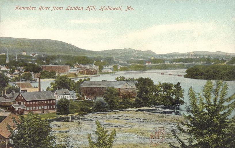


Hallowell, Maine
Hallowell is a city of 2,592 people in Kennebec County, Maine, founded in 1771.
Why visit Hallowell
Townapedia lists 54 museums and landmarks, 16 parks and trails, 36 places to eat, 7 places to stay and 8 attractions in and around town.
Highlights include Ladies Delight Light, Memorial Bridge, Algernon Bangs House and Capitol Complex Historic District.
July is the warmest month, with average highs of 80°F; January lows average 12°F.
Weather in Hallowell
Forecast from the National Weather Service. Full forecast
About Hallowell
Hallowell is a city in Kennebec County, Maine, United States. The population was 2,570 at the 2020 census. Popular with tourists, Hallowell is noted for its culture and old architecture. Hallowell is included in the Augusta, Maine, micropolitan New England City and Town Area.
From the Wikipedia article Hallowell, Maine (this version), under CC BY-SA 4.0.
Things to do8

Ladies Delight Light
Lighthouse · National Register of Historic Places · 4.0 mi
Lighthouse in Maine, United States


University of Maine at Augusta
School · 3.7 mi
University in Augusta, Maine

Museums and landmarks54

Algernon Bangs House
Monument and historic site · National Register of Historic Places · 3.1 mi
Augusta, Maine

Capitol Complex Historic District
Monument and historic site · National Register of Historic Places · 2.3 mi
Historic district in Augusta, Maine, United States

Capt. Nathaniel Stone House
Monument and historic site · National Register of Historic Places · 4.0 mi
House in Farmingdale, Maine

Colonial Theater
Monument and historic site · National Register of Historic Places · 3.1 mi
Former movie theater in Augusta, Maine, United States

Crosby Street Historic District
Monument and historic site · National Register of Historic Places · 3.0 mi
Historic district in Augusta, Maine

Cushnoc Archeological Site
Monument and historic site · National Register of Historic Places · 3.0 mi
Archaeological site in Maine, United States of America

D.V. Adams Co.-Bussell and Weston
Monument and historic site · National Register of Historic Places · 3.0 mi
Historic commercial building at 190 Water Street in downtown Augusta, Maine

Doughty Block
Monument and historic site · National Register of Historic Places · 2.9 mi
Historic commercial building at 265 Water Street in downtown Augusta, Maine

Dr. J.W. Ellis House
Monument and historic site · National Register of Historic Places · 2.9 mi
Historic house in Maine, United States

Ella R. Hodgkins Intermediate School
Monument and historic site · National Register of Historic Places · 3.6 mi
Historic school building Augusta, Maine, USA
Elm Hill Farm
Monument and historic site · National Register of Historic Places · 1.1 mi
Human settlement in Hallowell, Maine, United States of America
Former Augusta City Hall
Monument and historic site · National Register of Historic Places · 3.1 mi
City hall in Augusta, Maine
42 more on the map.
Parks, trails and playgrounds16


Capitol Park
Park · National Register of Historic Places · 2.4 mi
Park in Augusta, United States of America
Capitol Street, Augusta


Camden National Bank Ice Vault
Sports field and stadium · 1.2 mi
203 Whitten Road, Hallowell

4 more on the map.
Restaurants and cafes36

Ground Round Sports Grille
Restaurant · 1.2 mi
215 Whitten Road, Hallowell
Mo-Sa 11:00-18:00; Su 11:00-21:00




Begel Mania
Restaurant · Sandwich · 2.1 mi
190 Western Avenue, Augusta
Belle Boulangerie
Bakery · 1.4 mi
156 Water Street, Hallowell
We-Fr 08:00-14:00; Sa 09:00-12:30
24 more on the map.
History
The city is named for Benjamin Hallowell, a Boston merchant and one of the Kennebec Proprietors, holders of land originally granted to the Plymouth Company by the British monarchy in the 1620s.
The first settler of European descent was Deacon Pease Clark, who emigrated with his wife and son Peter from Attleborough, Massachusetts, in the spring of 1762. Legend has it that after disembarking on the west side of the Kennebec, near present-day Water Street, the Clarks took shelter in their overturned cart. On a riverfront lot measuring 50 rods (275 yards, about 250 meters), the Clark family raised corn, rye and other crops. The first land they cleared was occupied by the fire department in 1859.
In 1797, Harrington (later the city of Augusta) split from Hallowell to be a separate town. The part of Hallowell that is the current city was then known as "The Hook". Today, the city's population (2,467) is only slightly smaller than it was in 1820, the year Maine was separated from Massachusetts and became a state. Around 1830, Hallowell's inhabitants enjoyed the services of 71 stores along Water Street (a greater number than Augusta, which had a population of 1,000 and just 20 merchants).
From the History section of Hallowell, Maine on Wikipedia, under CC BY-SA 4.0.
Where to stay7
Churches and places of worship12
Alls Souls Church
Church · National Register of Historic Places · 2.9 mi
South Parish Congregational Church and Parish House
Church · National Register of Historic Places · 2.9 mi
St. Mark's Episcopal Church
Church · National Register of Historic Places · 2.8 mi
St. Mary's Church
Church · National Register of Historic Places · 2.4 mi
Saint Mary of the Assumption Catholic Church
Church · Roman Catholic · 2.4 mi
41 Western Avenue, Augusta
Sacred Heart Catholic Church
Church · Roman Catholic · 1.3 mi
14 Summer Street, Hallowell
Kennebec Valley Assembly of God
Church · Protestant · 2.2 mi
44 Hallowell Road, Chelsea
Maine Conference United Church of Christ
Church · 1.9 mi
337 State Street, Augusta
Shopping12
Gas and EV charging6
Schools, colleges and libraries25
Healthcare2
Map of Hallowell
178 places. The map loads OpenStreetMap tiles when you open it.
Climate by month
Monthly table
| Month | High | Low | Rain |
|---|---|---|---|
| Jan | 29°F | 12°F | 2.6 in |
| Feb | 32°F | 14°F | 2.3 in |
| Mar | 41°F | 23°F | 3.2 in |
| Apr | 54°F | 34°F | 3.8 in |
| May | 66°F | 45°F | 3.3 in |
| Jun | 74°F | 54°F | 4.0 in |
| Jul | 80°F | 60°F | 3.2 in |
| Aug | 79°F | 59°F | 3.4 in |
| Sep | 71°F | 51°F | 3.9 in |
| Oct | 58°F | 40°F | 4.7 in |
| Nov | 46°F | 30°F | 4.0 in |
| Dec | 35°F | 20°F | 3.4 in |
U.S. Climate Normals 1991-2020 for Augusta State Ap (3 mi away), NOAA NCEI.
People and cost of living
American Community Survey 5-year estimates, 2020-2024, U.S. Census Bureau. Estimates have margins of error, larger for small towns.
Disaster history
Kennebec County has had 15 federal disaster declarations since 2000, most often for severe storms.
- 2024-01-30: Severe Storm And Flooding (Severe Storm)
- 2023-09-14: Hurricane Lee (Hurricane)
- 2023-07-06: Severe Storm And Flooding (Flood)
- 2020-04-04: Covid-19 Pandemic (Biological)
- 2020-03-13: Covid-19 (Biological)
- 2018-01-02: Severe Storm And Flooding (Severe Storm)
OpenFEMA disaster declarations summaries.
Getting there and nearby towns
Augusta State Airport (AUG) is the nearest airport with scheduled flights listed in OpenStreetMap, 2 miles away.
- Farmingdale 3 mi southeast, about 5 min by car
- Augusta 5 mi northeast, about 9 min by car
- Gardiner 6 mi south, about 10 min by car
- Greene 18 mi west, about 28 min by car
- Waterville 19 mi northeast, about 31 min by car
- Lewiston 22 mi southwest, about 36 min by car
- Fairfield 23 mi northeast, about 38 min by car
- Bath 25 mi south, about 40 min by car
- Auburn 26 mi southwest, about 41 min by car
- Brunswick 28 mi south, about 46 min by car
Drive times are estimates from straight-line distance, not routes.
Local news
Headlines from INDB, the NEMICO news database.
Reviews, tips and questions
Loading what members have shared...
Sources and licences
- NCES EDGE (Public domain): public schools
- NOAA NCEI U.S. Climate Normals 1991-2020 (Public domain): climate by month
- OpenFEMA (Public domain): disaster declarations
- OpenStreetMap contributors (ODbL 1.0): places, airports, map data
- U.S. Census Bureau (Public domain): population, income, housing, education, commute
- Wikidata (CC0 1.0): elevation, founding date, time zone, website, landmarks and historic places
- Wikimedia Commons (see each image): photos
- Wikipedia (CC BY-SA 4.0): overview and history text
Photo credits
- Kennebec River from London Hill, Hallowell, ME, Unknown author Unknown author, Public domain
- Hallowell Powder House, BTVPhoto, CC BY-SA 4.0
- HallowellME ElmHillFarm, Magicpiano, CC BY-SA 4.0
- HallowellME MaineIndustrialSchoolForGirls 1, Magicpiano, CC BY-SA 4.0
- HallowellME MaineIndustrialSchoolForGirls 3, Magicpiano, CC BY-SA 4.0
- HallowellME MaineIndustrialSchoolForGirls 2, Magicpiano, CC BY-SA 4.0
- HallowellME SouthCongregationalChurch, Magicpiano, CC BY-SA 4.0
- HallowellME CityHall, Magicpiano, CC BY-SA 4.0
- HallowellME FireStation, Magicpiano, CC BY-SA 4.0
- HallowellME SecondStreet, Magicpiano, CC BY-SA 4.0
- HallowellME RowHouse, Magicpiano, CC BY-SA 4.0
- Rowhouse in Hallowell, Stanley Schwartz, Public domain
- HallowellME VaughanHomestead, Magicpiano, CC BY-SA 4.0
- Hallowell, Maine At Dusk, Paul VanDerWerf, CC BY 2.0
- SW Entrance into Capitol Park ( Augusta, Maine), Jim Roberts, CC BY-SA 4.0
- Ladies Delight Light, 2005, Lmichaud, CC BY-SA 3.0
- George Crosby House, Augusta ME, John Phelan, CC BY-SA 3.0
- Governor Hill Mansion 5, AlexiusHoratius, CC BY-SA 3.0
- St. Mary's Church, Augusta, Maine, Doug Kerr, CC BY-SA 2.0
- 180 Water Street, Augusta ME, John Phelan, CC BY-SA 3.0
- Old Post Office Augusta Maine 2013, Kenneth C. Zirkel, CC BY-SA 4.0
- 113 Winthrop Street, Augusta ME, John Phelan, CC BY-SA 3.0
- 188 Water Street, Augusta ME, John Phelan, CC BY-SA 3.0
- 265 Water Street, Augusta ME, John Phelan, CC BY-SA 3.0
- Old Cony High School Augusta Maine 2013, Kenneth C. Zirkel, CC BY-SA 4.0
- AugustaME StMarksChurch, Doug Kerr, CC BY-SA 2.0
- Restoration of Fort Western, Augusta, ME IMG 2046, Billy Hathorn, CC BY-SA 3.0
- 190 Water Street, Augusta ME, John Phelan, CC BY-SA 3.0
- Guy P Gannett House, Jim Roberts, CC BY-SA 4.0
- FarmingdaleME CaptNathanielStoneHouse, Magicpiano, CC BY-SA 4.0
- Cushnoc Trading Post, Maine Commemorative Tablet, Terry Ross, CC BY 2.0
- Vickery Building, Augusta ME, John Phelan, CC BY-SA 3.0
- Blaine House at Augusta, ME IMG 2041, Billy Hathorn, CC BY-SA 3.0
- 62 State Street, Augusta ME, John Phelan, CC BY-SA 3.0
- South Parish Congregational Church and Parish House, Kenneth C. Zirkel, CC BY-SA 4.0
- 11 Summer Street, Augusta ME, John Phelan, CC BY-SA 3.0
- 70 State Street, Augusta ME, John Phelan, CC BY-SA 3.0
- AugustaME ColonialTheater, Doug Kerr, CC BY-SA 2.0
- 154 State Street, Augusta ME, John Phelan, CC BY-SA 3.0
- The Algermon Bangs House, Jim Roberts, CC BY-SA 3.0


Page built October 30, 2026. Spotted a mistake? Tell us or suggest a place.