


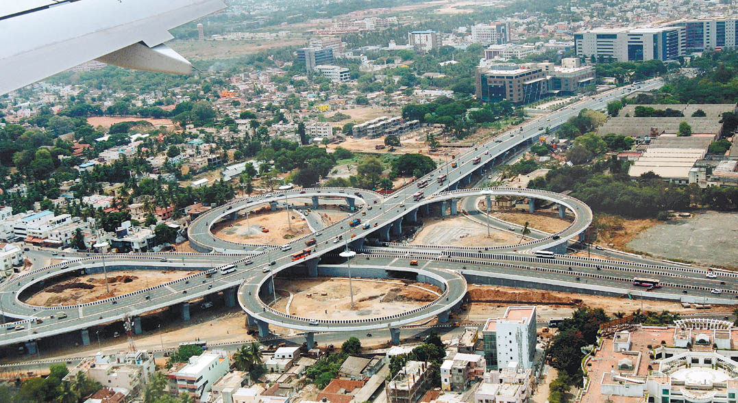


Saint Thomas Mount, India
Saint Thomas Mount is a town of 43,795 people in Tamil Nadu, India.
Why visit Saint Thomas Mount
Townapedia lists 10 museums and landmarks, 6 parks and trails, 56 places to eat, 10 places to stay and 10 attractions in and around town.
Highlights include Anna University, Central Polytechnic Chennai, Birla Planetarium and Tamilnadu Science and Technology Center.
Weather in Saint Thomas Mount
Forecast from MET Norway (CC BY 4.0). Full forecast
About Saint Thomas Mount
St. Thomas Mount (also known as Parangimalai) is a small hillock in the Chennai district of Tamil Nadu, India, near the neighbourhood of Guindy and close to Chennai International Airport. By extension, it is also the name of the neighbourhood surrounding the hillock.
From the Wikipedia article St. Thomas Mount (this version), under CC BY-SA 4.0.
Things to do10

Anna University
School · 4.5 km
State-run university in Guindy, Tamil Nadu

Central Polytechnic Chennai
School · 5.5 km
Government polytechnic college in Chennai, Tamil Nadu, India


Indian Institute of Technology Madras
School · 4.3 km
Autonomous public engineering and research institution located in Chennai, Tamil Nadu

Tamil Nadu Open University
School · 3.8 km
Open university based in Chennai



Museums and landmarks10

Birla Planetarium
Museum · 5.2 km
Planetarium museum in Chennai, India.

Tamilnadu Science and Technology Center
Museum · 5.0 km
The Tamil Nadu Science and Technology Centre (TNSTC) is a science museum and educational institution in Chennai, India. Established in...


Lt. Col. Samuel Dalrymple (Madras Artillery) Cupola
Monument and historic site · 0.6 km
Parks, trails and playgrounds6





Restaurants and cafes56

Sukkubhai Biryani
Restaurant · 0.6 km
14 Railway Station Road, Chennai
Mo-Su 10:00-22:00
Open in Google Maps · +91 44 2233 0444;+91 44 2233 0666;+91 44 2233 0888
Masaledaar Desi Rasoi
Restaurant · Indian · 2.0 km
11:30-15:30, 18:30-23:00
Hotel Om Muruga
Restaurant · 2.3 km
டிபன் - சாப்பாடு - வெரைட்டி ரைஸ் - பாஸ்ட் புட் சைவம் - அசைவம்
1325, LIG II TNHB Main Road, Chennai

Kanchi Singu Aiyyar Bhavan
Restaurant · 2.3 km
Parthasarathy Koil Street, Ekkaatuthangal
44 more on the map.
History
Historically, St. Thomas Mount was also known as Periya Malai (பெரிய மலை, meaning “Great Hill or Mount”) in Tamil and Monte Grande (“Great Mount”) in Portuguese, distinguishing it from the nearby Chinna Malai (“Little Mount”).The hill is also known locally as Parangimalai (பரங்கிமலை). The Madras Journal of Literature and Science (1887–1888) explains this name as “the Mountain of the Franks or Europeans,” associating it with the early Portuguese settlement.
The area is closely associated with local traditions. According to Hindu tradition, the sage Bhringi resided and meditated on the hillock in his quest to see Shiva. The locality thus came to be known as Bhringi malai, or "the hill of Bhringi", which over time morphed into "Parangimalai". It is also said that this connects several other regions in the city with the origin of their names. For instance, the place where he laid his pitcher, known in Tamil as kindi while performing worship, has now come to be known as "Guindy".
From the History section of St. Thomas Mount on Wikipedia, under CC BY-SA 4.0.
Where to stay10
Jai Ganesha Bhavan
Motel and hotel · 0.8 km
7/20 Police office road, St. Thomas mount, Chennai-650016
Churches and places of worship55
Viswaroopa Anjaneya Temple
Place of worship · Hindu · 1.9 km
3rd Main Road, chennai
Devi Karumari Amman Temple
Place of worship · Orthodox · 1.6 km
24th Street, Chennai
Shri Raghavendra Swamy Mutt (Mrithike Brindavana)
Place of worship · Madhwa · 2.0 km
16 10th Street, Nanganallur, Chennai
Shopping8
Gas and EV charging10
Schools, colleges and libraries26
District Branch Library, Maduvankarai
Library · 2.0 km
9 Five furlong road, Maduvankarai, Guindy, Chennai
District Branch Library, Velachery
Library · 2.4 km
Brindavan Nagar, Velachery West, Chennai
Healthcare46
MIOT International
Hospital · 2.3 km
4/112, Mount Poonamalle High Rd, Sathya Nagar, Manapakkam, Chennai, Tamil Nadu 600089
Star Pharmacy Adambakkam
Clinic and pharmacy · 1.7 km
64/1 Kakkan Nagar Main Road, chennai
Madras Heart Centre and Super Speciality Hospitals Pvt Ltd
Hospital · 2.4 km
Plot No: C138, C139, C140 Nanganallur 1st Main Road, Chennai
Military Hospital
Hospital · 1.0 km
Mount Poonamalle High Rd, Seven Wells, St.Thomas Mount, Tamil Nadu 600016
Map of Saint Thomas Mount
237 places. The map loads OpenStreetMap tiles when you open it.
Getting there and nearby towns
Chennai International Airport (MAA) is the nearest airport with scheduled flights listed in OpenStreetMap, 3 km away.
- Manapakkam 3 km northwest, about 3 min by car
- Meenambakkam 3 km southwest, about 3 min by car
- Pallāvaram 6 km southwest, about 6 min by car
- Ambattur 11 km north, about 11 min by car
- Tambaram 12 km southwest, about 12 min by car
- Chennai 13 km northeast, about 13 min by car
- Avadi 16 km northwest, about 16 min by car
- Vandalūr 18 km southwest, about 18 min by car
- Tiruvottiyūr 21 km northeast, about 21 min by car
- Kanchipuram 57 km west, about 57 min by car
Drive times are estimates from straight-line distance, not routes.
Local news
Headlines from INDB.
Reviews, tips and questions
Loading what members have shared...
Sources and licences
- GeoNames (CC BY 4.0): population, coordinates, regions and time zone
- OpenStreetMap contributors (ODbL 1.0): places, airports, map data
- Wikidata (CC0 1.0): elevation, founding date, time zone, website, landmarks and historic places
- Wikimedia Commons (see each image): photos
- Wikipedia (CC BY-SA 4.0): overview and history text
Photo credits
- Annadurai statue, Srinath1905, CC BY-SA 3.0
- IITMmensa, Mzwirlein, CC0
- Kathipara, Guru coolguy ( talk ), Public domain
- Saidapet Bridges Adyar River Chennai Jul18 DSC05378, Timothy A. Gonsalves, CC BY-SA 4.0
- Tamil Virtual Academy, Thamizhpparithi Maari, CC BY-SA 4.0
- Periyar Science and Technology Centre and Birla Planetarium, Chennai 46, Sivahari, CC BY-SA 4.0
- Guindy national park, abhidg, CC BY 2.0
- St. Thomas Garrison's church1, Ssriram mt, CC BY-SA 4.0
- St.Anne's Church OuterView, Mariya Ronald, CC0
- Aerial SE St Thomas Mount Chennai Jul25 R16 07931, Timothy A. Gonsalves, CC BY-SA 4.0
- Nanganallur Hanuman Temple 2005 12 29, No machine-readable author provided. Ganeshk assumed (based on copyright claims)., CC BY-SA 2.5
- Chennai Trade Centre, Tamilnadu Trade Promotion Organisation (Govt of Tamilnadu, India), CC BY-SA 4.0
- St. Patrcik's Chennai2, Ssriram mt, CC BY-SA 4.0
- HIET-Main-Block, Hietchennai, CC BY-SA 4.0
- Side St Thomas Mount Church Chennai Aug22 A7C 02292, This Photo was taken by Timothy A. Gonsalves . Feel free to use my photos, but please mention me as the author. I would much appreciate if you send me an email [email protected] or write on my talk..., CC BY-SA 4.0
- St Patricks Church Chennai, This Image was created by User:PlaneMad . If you are using the image under the creative commons share alike license please credit the photo CC-by-sa PlaneMad/Wikimedia and include a link to this..., CC BY-SA 3.0
- RadissonBluChennai1, Rasnaboy, CC0
- Main Entrance St Thomas Mount Church Chennai Aug22 A7C 02249, This Photo was taken by Timothy A. Gonsalves . Feel free to use my photos, but please mention me as the author. I would much appreciate if you send me an email [email protected] or write on my talk..., CC BY-SA 4.0
- ST. THOMAS MT. - panoramio (1), RAJUKHAN SR RAJESH, CC BY-SA 3.0
- Random Bush Macro click, Gopikrishnancs, CC BY-SA 4.0
- ST. THOMAS MT. - panoramio (11), RAJUKHAN SR RAJESH, CC BY-SA 3.0
- Panorama Chennai Airport Runway 0725 Aug22 A7C 02299-Pano-2, This Photo was taken by Timothy A. Gonsalves . Feel free to use my photos, but please mention me as the author. I would much appreciate if you send me an email [email protected] or write on my talk..., CC BY-SA 4.0
- St. Thomas Mount Shrine Altar, Tj Tini, CC0
- Chennai skyline mt2, Ajayy99, CC BY-SA 3.0
- Chennai st.thomas mount skyline, Ajayy99, CC BY-SA 3.0
- ST. THOMAS MT. - panoramio (3), RAJUKHAN SR RAJESH, CC BY-SA 3.0
- ST. THOMAS MT. - panoramio (4), RAJUKHAN SR RAJESH, CC BY-SA 3.0
- ST. THOMAS MT. - panoramio (2), RAJUKHAN SR RAJESH, CC BY-SA 3.0
- Statue Mary Untier Knots Thomas Mount Chennai Aug22 A7C 02267, This Photo was taken by Timothy A. Gonsalves . Feel free to use my photos, but please mention me as the author. I would much appreciate if you send me an email [email protected] or write on my talk..., CC BY-SA 4.0
- Indigo A321 VT-IMS Landing6 Chennai Aug22 D72 24892, This Photo was taken by Timothy A. Gonsalves . Feel free to use my photos, but please mention me as the author. I would much appreciate if you send me an email [email protected] or write on my talk..., CC BY-SA 4.0
- Indigo A321 VT-IMS Landing1 Chennai Aug22 D72 24885, This Photo was taken by Timothy A. Gonsalves . Feel free to use my photos, but please mention me as the author. I would much appreciate if you send me an email [email protected] or write on my talk..., CC BY-SA 4.0
- Indigo ATR72 VT-IYG Approach Chennai Aug22 A7C 02270, This Photo was taken by Timothy A. Gonsalves . Feel free to use my photos, but please mention me as the author. I would much appreciate if you send me an email [email protected] or write on my talk..., CC BY-SA 4.0
- Station Cross XIV Thomas Mount Chennai Aug22 R16 06211, This Photo was taken by Timothy A. Gonsalves . Feel free to use my photos, but please mention me as the author. I would much appreciate if you send me an email [email protected] or write on my talk..., CC BY-SA 4.0
- Interior Nave Thomas Church Mount Chennai Aug22 A7C 02257, This Photo was taken by Timothy A. Gonsalves . Feel free to use my photos, but please mention me as the author. I would much appreciate if you send me an email [email protected] or write on my talk..., CC BY-SA 4.0
- Relic 8 Apostle Thomas Mount Chennai Aug22 A7C 02260, This Photo was taken by Timothy A. Gonsalves . Feel free to use my photos, but please mention me as the author. I would much appreciate if you send me an email [email protected] or write on my talk..., CC BY-SA 4.0
- Statue Mother Teresa Thomas Mount Chennai Aug22 A7C 02284, This Photo was taken by Timothy A. Gonsalves . Feel free to use my photos, but please mention me as the author. I would much appreciate if you send me an email [email protected] or write on my talk..., CC BY-SA 4.0
- Pilgrim Mary St Thomas Mount Aug22 A7C 02293, This Photo was taken by Timothy A. Gonsalves . Feel free to use my photos, but please mention me as the author. I would much appreciate if you send me an email [email protected] or write on my talk..., CC BY-SA 4.0
- Indigo A321 VT-IMS Landing4 Chennai Aug22 D72 24890, This Photo was taken by Timothy A. Gonsalves . Feel free to use my photos, but please mention me as the author. I would much appreciate if you send me an email [email protected] or write on my talk..., CC BY-SA 4.0
- Statue Thomas Infant Jesus Mount Chennai Aug22 A7C 02264, This Photo was taken by Timothy A. Gonsalves . Feel free to use my photos, but please mention me as the author. I would much appreciate if you send me an email [email protected] or write on my talk..., CC BY-SA 4.0
- Last Supper Mural Thomas Mount Chennai Aug22 A7C 02287, This Photo was taken by Timothy A. Gonsalves . Feel free to use my photos, but please mention me as the author. I would much appreciate if you send me an email [email protected] or write on my talk..., CC BY-SA 4.0


Page built November 3, 2026. Spotted a mistake? Tell us or suggest a place.