


Rāmsar, Iran
رامسر
Rāmsar is a town of 35,997 people in Māzandarān, Iran, founded in 1943.
Why visit Rāmsar
Townapedia lists 7 museums and landmarks, 5 parks and trails, 27 places to eat, 14 places to stay and 1 attraction in and around town.
Highlights include hayat._.hayat, Marble Palace, Amusement Park and Old Ramsar Hotel.
Weather in Rāmsar
Forecast from MET Norway (CC BY 4.0). Full forecast
About Rāmsar
Ramsar (Persian: رامسر) is a city in the Central District of Ramsar County, Mazandaran province, Iran, serving as capital of both the county and the district. It also serves as the administrative center for Sakht Sar Rural District.
From the Wikipedia article Ramsar, Iran (this version), under CC BY-SA 4.0.
Travel tips from other travellers: Rāmsar on Wikivoyage (CC BY-SA 4.0).
Things to do1

Museums and landmarks7

hayat._.hayat
Museum · 0.8 km
کافه گالریچای، قهوه و انواع نوشیدنی به همراه شیرینی محلی
194 بلوار مطهری, رامسر
10:00-13:30,16:00-22:30

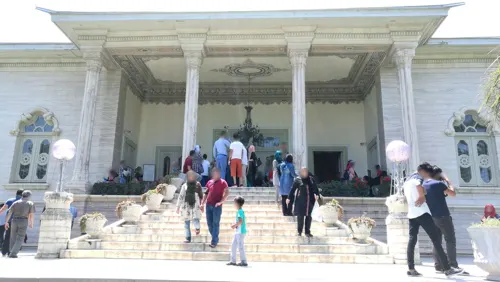
Marble Palace
Museum · 1.7 km
Palace in Ramsar, Iranian national heritage site
Parks, trails and playgrounds5





Restaurants and cafes27

Bakhshian Restaurant
Restaurant · 0.7 km
کباب ترش، جوجه کباب، کباب کوبیده، شیشلیگ، دل، قلوه، جگر
بلوار مطهری
Mo-Su 07:00-23:00
DIO Cafe
Cafe · Cake, Coffee Shop, Crepe, Ice Cream · 2.0 km
بلوار شهید باهنر
Mo-Su 09:00-00:00

Gusto resturante
Cafe · Italian Pizza, Cake, Pasta, Coffee Shop · 2.5 km
بلوار رزاقی
Mo-Su 09:00-00:00
Ocafe اُکافه
Cafe · Coffee Shop, Coffee · 0.6 km
1 بلوار مطهری, رامسر
Mo-Su 09:00-23:00
hayat e hayat
Cafe · Tea, Coffee, Pastry, Cookies, Snacks · 0.8 km
194 بلوار مطهری, رامسر
10:00-13:30,16:00-22:30



15 more on the map.
History
In 1971, Ramsar hosted the Ramsar Convention on Wetlands of International Importance, also known as the Convention on Wetlands. This international treaty for the conservation and sustainable use of designated wetlands (which under the treaty are known as Ramsar sites) was signed in and named after the city of Ramsar.
From the History section of Ramsar, Iran on Wikipedia, under CC BY-SA 4.0.
Where to stay14
Churches and places of worship1
Shopping12
Gas and EV charging1
Schools, colleges and libraries5
Healthcare8
Map of Rāmsar
81 places. The map loads OpenStreetMap tiles when you open it.
Getting there and nearby towns
Ramsar International Airport (RZR) is the nearest airport with scheduled flights listed in OpenStreetMap, 4 km away.
- Katālem va Sādāt Shahr 5 km southeast, about 5 min by car
- Sefīd Tameshk 7 km northwest, about 7 min by car
- Chāboksar 9 km northwest, about 9 min by car
- Sarvelāt 10 km northwest, about 10 min by car
- Gīlāndeh 11 km northwest, about 11 min by car
- Līmāk 12 km southeast, about 12 min by car
- Tonekābon 23 km southeast, about 23 min by car
- Lāhījān 65 km northwest, about 1 h by car
- Kalārdasht 65 km southeast, about 1 h by car
- Chālūs 75 km southeast, about 1 h 15 min by car
Drive times are estimates from straight-line distance, not routes.
Local news
Headlines from INDB.
Reviews, tips and questions
Loading what members have shared...
Sources and licences
- GeoNames (CC BY 4.0): population, coordinates, regions and time zone
- Mapillary (see each image): photos
- OpenStreetMap contributors (ODbL 1.0): places, airports, map data
- Wikidata (CC0 1.0): elevation, founding date, time zone, website, landmarks and historic places
- Wikimedia Commons (see each image): photos
- Wikipedia (CC BY-SA 4.0): overview and history text
Photo credits
- Ramsar skyline 2019, Behnam Yousefi, CC BY 4.0
- اتاق مهمان کاخ رامسر, R. Rasoole Mehrabani, CC BY-SA 4.0
- Old Hotel Ramsar, hannaneh710, CC BY 2.0
- Palais ramsar, Fabienkhan, CC BY-SA 2.5
- Royal Palace Ramsar 1, سعید اشتری, CC BY-SA 4.0
- Ramsar - panoramio (2), Ali Safdarian, CC BY 3.0
- Ramsar Alleys - panoramio, Ali Safdarian, CC BY 3.0
- Ramsar, Mazandaran Province, Iran - panoramio, هاوبەشی مامە دارا, CC BY 3.0
- Ramsar, A heavenly City - panoramio, Ali Safdarian, CC BY 3.0
- Wonderful^ - panoramio, Ali Safdarian, CC BY 3.0
- Ramsar, Mazandaran Province, Iran - panoramio (2), هاوبەشی مامە دارا, CC BY 3.0
- Amazing Green - panoramio, Ali Safdarian, CC BY 3.0
- حوض کاخ موزه شاه در رامسر - panoramio, Omid Jafarnezhad (om…, CC BY 3.0
- کاخ شاه - panoramio, Mehrdad Sarhangi, CC BY 3.0
- رامسر - panoramio, Mehrdad Sarhangi, CC BY 3.0
- Ficus carica 449599427, portioid, CC BY-SA 4.0
- Ramsar - panoramio (3), Ali Safdarian, CC BY 3.0
- (((مناظر رامسر ))) - panoramio, auoob farabi, CC BY-SA 3.0
- Casino Boulevard - panoramio, Ali Safdarian, CC BY 3.0
- Casino - panoramio (14), Ali Safdarian, CC BY 3.0
- Casino Path - panoramio, Ali Safdarian, CC BY 3.0
- Ramsar, Mazandaran, Iran - panoramio, saeedk6400, CC BY 3.0
- Casino Park - panoramio (1), Ali Safdarian, CC BY 3.0
- Ramsar Big Hotel and Old Hotel - panoramio (4), Ali Safdarian, CC BY 3.0
- Green Plants that the municipality has shaped - panoramio, Ali Safdarian, CC BY 3.0
- Casino Park - panoramio, Ali Safdarian, CC BY 3.0
- Such a nice place - panoramio, Ali Safdarian, CC BY 3.0
- Casino Path - panoramio (1), Ali Safdarian, CC BY 3.0
- Ramsar Old Hotel - panoramio (7), Ali Safdarian, CC BY 3.0
- Ramsar Old Hotel - panoramio (6), Ali Safdarian, CC BY 3.0
- Ramsar Big Hotel and Old Hotel - panoramio (1), Ali Safdarian, CC BY 3.0
- Ramsar Hotel Site - panoramio, Ali Safdarian, CC BY 3.0
- Ramsar Big Hotel and Old Hotel - panoramio (3), Ali Safdarian, CC BY 3.0
- Ramsar Big Hotel and Old Hotel - panoramio (2), Ali Safdarian, CC BY 3.0
- بلوار معلم من عدسة عقيل - panoramio, khazali aqeel, CC BY-SA 3.0
- Hotelramsar2.tayefi, E.tayefi, CC BY-SA 4.0
- Beautiful City of Ramsar - panoramio, Ali Safdarian, CC BY 3.0
- Ramsar Big Hotel and Old Hotel - panoramio, Ali Safdarian, CC BY 3.0
- Ramsar Old Hotel - panoramio (5), Ali Safdarian, CC BY 3.0
- Lion Statue - panoramio (1), Ali Safdarian, CC BY 3.0
- Street-level photo, pilsa, CC BY-SA 4.0
- Street-level photo, pilsa, CC BY-SA 4.0
- Street-level photo, pilsa, CC BY-SA 4.0
- Street-level photo, chenabeel, CC BY-SA 4.0
- Street-level photo, pilsa, CC BY-SA 4.0
- Street-level photo, pilsa, CC BY-SA 4.0
- Street-level photo, pilsa, CC BY-SA 4.0
- Street-level photo, pilsa, CC BY-SA 4.0
- Street-level photo, pilsa, CC BY-SA 4.0
- Street-level photo, pilsa, CC BY-SA 4.0


))_-_panoramio.jpg)


Page built November 8, 2026. Spotted a mistake? Tell us or suggest a place.