


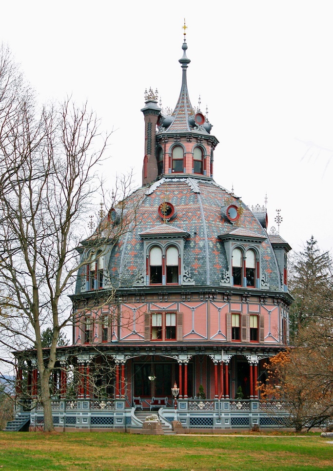
Irvington, New York
Irvington is a village of 6,531 people in Westchester County, New York.
Why visit Irvington
Townapedia lists 58 museums and landmarks, 20 parks and trails, 30 places to eat, 2 places to stay and 5 attractions in and around town.
Highlights include Mercy University, New Tappan Zee Bridge, Villa Lewaro and Washington Irving Memorial.
July is the warmest month, with average highs of 86°F; January lows average 23°F, and about 33 inches of snow fall in a normal year.
Weather in Irvington
Forecast from the National Weather Service. Full forecast
About Irvington
Irvington, sometimes known as Irvington-on-Hudson, is a suburban village of the town of Greenburgh in Westchester County, New York, United States. It is a suburb of New York City, 20 miles (32 km) north of Midtown Manhattan in New York City, and is served by a station stop on the Metro-North Hudson Line. To the north of Irvington is the village of Tarrytown, to the south the village of Dobbs Ferry, and to the east unincorporated parts of Greenburgh, including East Irvington. Irvington includes within its boundaries the community of Ardsley-on-Hudson, which has its own ZIP code and Metro-North station, but which should not be confused with the nearby village of Ardsley.
From the Wikipedia article Irvington, New York (this version), under CC BY-SA 4.0.
Things to do5

Mercy University
School · 0.9 mi
University in Dobbs Ferry, USA
555 Broadway, Dobbs Ferry

New Tappan Zee Bridge
Bridge · 2.8 mi
Bridge across the Hudson River, New York, United States of America
St. Thomas Aquinas College
School · 3.6 mi
Liberal arts college in New York
Tappan Zee Bridge
Bridge · 2.8 mi
Former road bridge in the State of New York

Museums and landmarks58

Villa Lewaro
Monument and historic site · National Register of Historic Places · 0.6 mi
Historic house in New York, United States

Washington Irving Memorial
Monument and historic site · National Register of Historic Places · 1.0 mi
Memorial in Irvington, New York, United States

Abner Concklin House
Monument and historic site · National Register of Historic Places · 3.4 mi
Historic house in Palisades, New York
Armour-Stiner House
Monument and historic site · National Register of Historic Places
Historic house in Irvington, New York, United States

Big House
Monument and historic site · National Register of Historic Places · 2.8 mi
Historic house in New York, United States

Christ Episcopal Church
Monument and historic site · National Register of Historic Places · 2.8 mi
Church building in Tarrytown, New York, United States

Church of St. Barnabas
Monument and historic site · National Register of Historic Places · 0.4 mi
Church in Irvington, New York
Cliffside
Monument and historic site · National Register of Historic Places · 2.7 mi
Listed on the National Register of Historic Places

Closter Road-Oak Tree Road Historic District
Monument and historic site · National Register of Historic Places · 3.0 mi
Historic house in New York, United States

Dederer Stone House-Stonehurst
Monument and historic site · National Register of Historic Places · 2.9 mi
Historic house in New York, United States

East Irvington School
Monument and historic site · National Register of Historic Places · 1.3 mi
School building in New York, United States of America
Edward Harden Mansion
Monument and historic site · National Register of Historic Places · 3.4 mi
Historic house in New York, United States
46 more on the map.
Parks, trails and playgrounds20


Patriot's Park
Park · National Register of Historic Places · 3.3 mi
Westchester County, New York




8 more on the map.
Restaurants and cafes30

Ardsley Cucina
Restaurant · Italian · 1.5 mi
935 Saw Mill River Road, Ardsley
Mo-Sa 11:00-21:00; Su 11:00-20:00
Ardsley Diner
Restaurant · Diner · 1.8 mi
731 Saw Mill River Road, Ardsley
Mo-Th 10:00-21:00; Fr 10:00-22:00; Sa 08:00-22:00; Su 08:00-21:00
Half Moon
Restaurant · American, Seafood · 1.8 mi
1 High Street, Dobbs Ferry
Mo-Th 11:30-15:00,17:30-22:00; Fr 11:30-15:00, 16:00-23:00; Sa...

Harper's Restaurant & Bar
Diner · American · 1.4 mi
92 Main Street, Dobbs Ferry
Tu-Fr 05:00-21:15; Sa, Su 11:30-14:30, 17:00-21:15
La Catena
Restaurant · Italian · 1.6 mi
871 Saw Mill River Road, Ardsley
Mo-Th 15:00-21:45; Fr 15:00-22:45; Sa 12:00-22:45; Su 12:00-21:45
Sam's Italian Ristorante
Restaurant · Italian, Pizza · 1.3 mi
128 Main Street, Dobbs Ferry
11:30-21:30
Sushi Mike's
Restaurant · Sushi · 1.3 mi
146 Main Street, Dobbs Ferry
Tu-Th, Su 15:00-21:00; Fr, Sa 15:00-21:30
Sushi Niji
Restaurant · Sushi · 1.5 mi
73 Main Street, Dobbs Ferry
Mo, We, Th 11:15-15:15, 16:15-22:00; Fr 11:15-15:15, 16:15-22:30;...
The Brick Oven Pizza
Restaurant · Pizza · 1.3 mi
147 Main Street, Dobbs Ferry
Mo-Sa 10:00-22:00; Su 10:00-21:00
The Cookery
Restaurant · Italian, Gastropub · 1.5 mi
39 Chestnut Street, Dobbs Ferry
We-Th 17:00-21:00; Fr 17:00-22:00; Sa 11:30-14:30, 17:00-22:00; Su...
Tomatillo
Restaurant · Mexican · 1.3 mi
13 Cedar Street, Dobbs Ferry
Tu-Th 11:30-20:30; Sa 11:00-21:30; Su 11:00-20:30; Fr 12:00-21:30
18 more on the map.
History
Before the area where Irvington is now located was settled by Europeans, it was inhabited by the Wickquasgeck, a band of the Wappingers, related to the Lenape (Delaware) tribes which dominated lower New York state and New Jersey. The Wickquasgeck still lived in the area as late as 1775.
After the Dutch came to the area in the 1600s, the land was part of the Bisightick tract of the Adrian Van der Donck grant. Early settlers in the Irvington area were Stephen Ecker, Jan Harmes, Captain John Buckhout, and Barent Dutcher. The Van der Donck grant was purchased by Frederick Philipse in 1682, after the British had taken over the area in 1664. At first it was settled by tenant farmers, but by the 1700s, most of the settlers were artisans. The King's Highway – later the Albany Post Road, and now Broadway – which connected New York City with Albany, was built through the settlement by the 1720s, which created a need for inns and taverns to supplement Odell's Tavern, which was built in 1690.
From the History section of Irvington, New York on Wikipedia, under CC BY-SA 4.0.
Where to stay2
Churches and places of worship10
Christ Church
Church · National Register of Historic Places · 3.1 mi
Church of St. Joseph of Arimathea
Church · National Register of Historic Places · 1.4 mi
First Reformed Church
Church · National Register of Historic Places · 2.6 mi
South Presbyterian Church
Church · National Register of Historic Places · 1.4 mi
Greenburgh Hebrew Center
Place of worship · Conservative · 1.1 mi
515 Broadway, Dobbs Ferry
Shopping3
Gas and EV charging4
Schools, colleges and libraries52
Irvington Middle & Highs School Campus
School · 0.6 mi
40 North Broadway, Irvington
Healthcare5
Saint John's Riverside Hospital - Dobbs Ferry Pavilion
Hospital · 1.4 mi
128 Ashford Avenue, Dobbs Ferry
Map of Irvington
189 places. The map loads OpenStreetMap tiles when you open it.
Climate by month
Monthly table
| Month | High | Low | Rain | Snow |
|---|---|---|---|---|
| Jan | 40°F | 23°F | 3.9 in | 9.4 in |
| Feb | 43°F | 24°F | 3.3 in | 10.9 in |
| Mar | 51°F | 31°F | 4.4 in | 5.8 in |
| Apr | 63°F | 40°F | 4.3 in | 0.7 in |
| May | 73°F | 50°F | 4.3 in | 0.0 in |
| Jun | 81°F | 59°F | 4.6 in | 0.0 in |
| Jul | 86°F | 64°F | 4.5 in | 0.0 in |
| Aug | 84°F | 63°F | 4.4 in | 0.0 in |
| Sep | 77°F | 56°F | 4.6 in | 0.0 in |
| Oct | 65°F | 45°F | 4.4 in | 0.0 in |
| Nov | 54°F | 36°F | 3.9 in | 0.3 in |
| Dec | 44°F | 29°F | 4.7 in | 5.6 in |
U.S. Climate Normals 1991-2020 for Dobbs Ferry-Ardsley Hcn (3 mi away), NOAA NCEI.
People and cost of living
American Community Survey 5-year estimates, 2020-2024, U.S. Census Bureau. Estimates have margins of error, larger for small towns.
Disaster history
Westchester County has had 21 federal disaster declarations since 2000, most often for hurricanes.
- 2024-01-30: Severe Storm And Flooding (Flood)
- 2021-09-05: Remnants Of Hurricane Ida (Hurricane)
- 2021-09-02: Remnants Of Hurricane Ida (Hurricane)
- 2021-08-22: Hurricane Henri (Hurricane)
- 2020-10-02: Tropical Storm Isaias (Hurricane)
- 2020-03-20: Covid-19 Pandemic (Biological)
OpenFEMA disaster declarations summaries.
Getting there and nearby towns
Westchester County Airport (HPN) is the nearest airport with scheduled flights listed in OpenStreetMap, 9 miles away.
- Dobbs Ferry 2 mi south, about 3 min by car
- Tarrytown 2 mi north, about 3 min by car
- Ardsley 2 mi southeast, about 3 min by car
- Elmsford 3 mi northeast, about 5 min by car
- Hastings-on-Hudson 3 mi south, about 5 min by car
- Sparkill 3 mi west, about 6 min by car
- Greenville 4 mi southeast, about 6 min by car
- Hartsdale 4 mi east, about 6 min by car
- Fairview 4 mi east, about 6 min by car
- Sleepy Hollow 4 mi north, about 7 min by car
Drive times are estimates from straight-line distance, not routes.
Local news
Headlines from INDB, the NEMICO news database.
Reviews, tips and questions
Loading what members have shared...
Sources and licences
- NCES EDGE (Public domain): public schools
- NOAA NCEI U.S. Climate Normals 1991-2020 (Public domain): climate by month
- OpenFEMA (Public domain): disaster declarations
- OpenStreetMap contributors (ODbL 1.0): places, airports, map data
- U.S. Census Bureau (Public domain): population, income, housing, education, commute
- Wikidata (CC0 1.0): landmarks and historic places
- Wikimedia Commons (see each image): photos
- Wikipedia (CC BY-SA 4.0): overview and history text
Photo credits
- Washington Irving Memorial Irvington, Beyond My Ken, CC BY-SA 4.0
- Villa-lewaro crop, Dmadeo ; cropped by Beyond My Ken ( talk ) 19:28, 23 March 2011 (UTC), CC BY-SA 4.0
- East Irvington School, Beyond My Ken, CC BY 3.0
- ABNER CONCKLIN HOUSE, PALISADES, ROCKLAND COUNTY, NY, JERRYE & ROY KLOTZ, M.D., CC BY-SA 4.0
- 2 and 8 North Grove Street, Tarrytown, NY, Daniel Case, CC BY-SA 3.0
- Armour-Stiner House (1), csouza_79, CC BY 2.0
- Patriot's Park, Tarrytown-Sleepy Hollow, NY, Daniel Case, CC BY-SA 3.0
- CHRIST CHURCH, SPARKILL, ROCKLAND COUNTY, NY, JERRYE & ROY KLOTZ, M.D., CC BY-SA 4.0
- Lyndhurst Tarrytown NY - front facade, Unknown author, CC BY-SA 3.0
- Dobbs Ferry, NY, post office, Daniel Case, CC BY-SA 3.0
- Estherwood, Dobbs Ferry, NY, Daniel Case, CC BY-SA 3.0
- HartsdaleNY LeoFriedlanderStudio, User:Magicpiano, CC BY-SA 4.0
- Church of St. Joseph of Arimathea, Oct 2012, DK Big Fish, CC0
- Piermont Drawbridge, Alexisrael, CC BY-SA 3.0
- First Baptist Church of Tarrytown, NY, Daniel Case, CC BY-SA 3.0
- ROCKLAND ROAD BRIDGE HISTORIC DISTRICT, PIERMONT, ROCKLAND COUNTY, NY, JERRYE AND ROY KLOTZ, M.D., CC BY-SA 4.0
- NEIDERHURST, PALISADES, ROCKLAND COUNTY, NY, JERRYE & ROY KLOTZ, M.D., CC BY-SA 4.0
- HenryDraperObservatory, Daniel Case, CC BY-SA 3.0
- FIRST REFORMED CHURCH, PIEDMONT, ROCKLAND COUNTY NY, JERRYE & ROY KLOTZ, M.D., CC BY-SA 4.0
- Tarrytown Music Hall 2010, Ed from Queens, USA. Cropped and color-corrected slightly prior to upload by Daniel Case, CC BY 2.0
- McVickar House, Irvington, NY, Daniel Case, CC BY-SA 3.0
- BIG HOUSE, PALISADES, ROCKLAND COUNTY, NY, JERRYE & ROY KLOTZ, M.D., CC BY-SA 4.0
- HADDOCK'S HALL, PIERMONT, ROCKLAND COUNTY, NY, JERRYE & ROY KLOTZ, M.D., CC BY-SA 4.0
- Lord and Burnham Building, Daniel Case, CC BY-SA 3.0
- LITTLE HOUSE, PALISADES, ROCKLAND COUNTY NY, JERRYE & ROY KLOTZ, M.D., CC BY-SA 4.0
- Nuits, Ardsley-on-Hudson, NY, Daniel Case, CC BY-SA 3.0
- WASHINGTON SPRING ROAD-WOODS ROAD HISTORIC DISTRICT, ROCKLAND COUNTY, NY, JERRYE & ROY KLOTZ, M.D., CC BY-SA 4.0
- Rockland ROAD BRIDGE, PIERMONT, ROCKLAND COUNTY, NY, JERRYE & ROY KLOTZ, M.D., CC BY-SA 4.0
- Trolley exploring - an electric railroad guide to historic and picturesque places about New York, New Jersey, and New England (1904) (14574250168), Internet Archive Book Images, No restrictions
- Philipsburg Manor 3, Gryffindor, CC BY-SA 3.0
- Church of St Barnabas, Irvington, NY, Daniel Case, CC BY-SA 3.0
- PalisadesNY HaringEberleHouse, Magicpiano, CC BY-SA 4.0
- TarrytownNY GlenwoldeParkHD 1, Magicpiano, CC BY-SA 4.0
- CLOSTER ROAD-OAK TREE ROAD HISTORIC DISTRICT, PALISADES, ROCKLAND COUNTY, NY, JERRYE & ROY KLOTZ, M.D., CC BY-SA 4.0
- DEDERER STONE HOUSE, ORANGETOWN, ROCKLAND COUNTY, NY, JERRYE & ROY KLOTZ, M.D., CC BY-SA 4.0
- Spanish American War Monument to the 71st Infantry Regiment, Oct 2012, DK Big Fish, Public domain
- 352 Piermont Avenue - Piermont NY, Adam Moss, CC BY-SA 2.0
- Foster Memorial AME Zion Church, Daniel Case, CC BY-SA 3.0
- TarrytownNY FormerWashingtonIrvingHighSchool, Magicpiano, CC BY-SA 4.0
- ONDERDONK HOUSE, PIERMONT, ROCKLAND COUNTY, NY, JERRYE & ROY KLOTZ, M.D., CC BY-SA 4.0


Page built October 30, 2026. Spotted a mistake? Tell us or suggest a place.