
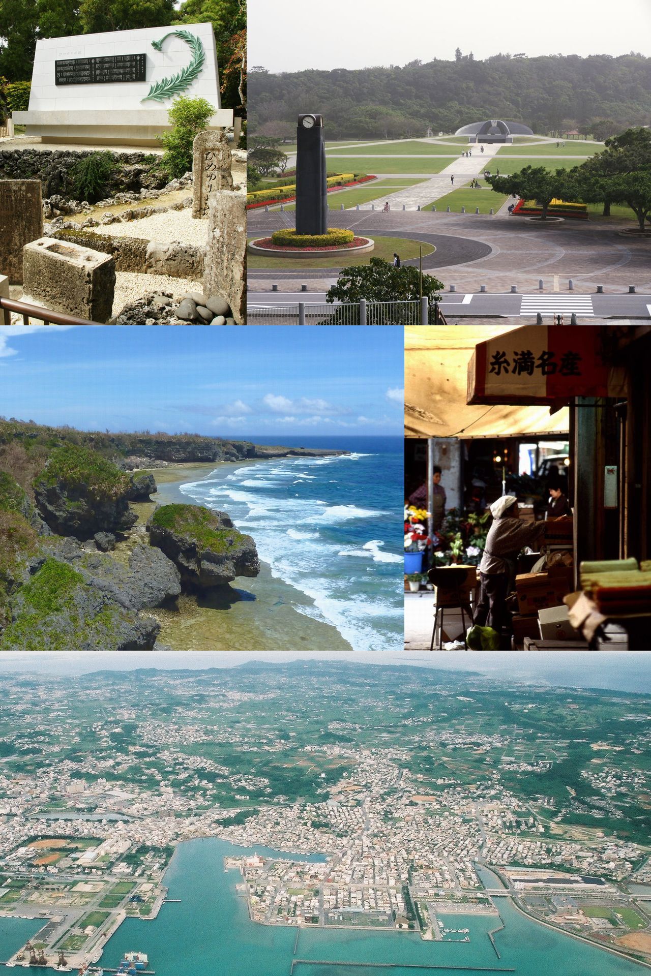


Itoman, Japan
糸満市
Itoman is a town of 61,007 people in Okinawa, Japan, founded in April 1, 1908.
Why visit Itoman
Townapedia lists 59 museums and landmarks, 51 parks and trails, 78 places to eat, 6 places to stay and 10 attractions in and around town.
Highlights include DMM KARIYUSHI AQUARIUM, Okinawa University, Himeyuri Peace Museum and Cornerstone of Peace.
Weather in Itoman
Forecast from MET Norway (CC BY 4.0). Full forecast
About Itoman
Itoman (糸満市, Itoman-shi; Japanese pronunciation: [ì.tó̞.mä́ɴ́, -mä́ɰ̃̀.ɕì]; Okinawan: いちゅまん ʔIcuman) is a city located in Okinawa Prefecture, Japan. The city occupies the southern tip of Okinawa Island. As of 1 October 2020, the city has an estimated population of 61,007 and a population density of 1,308.32 inhabitants per square kilometre (3,388.5/sq mi). The total area is 46.63 km2 (18.00 sq mi).
From the Wikipedia article Itoman, Okinawa (this version), under CC BY-SA 4.0.
Travel tips from other travellers: Itoman on Wikivoyage (CC BY-SA 4.0).
Things to do10

Okinawa University
School · 8.8 km
Higher education institution in Okinawa Prefecture, Japan




Museums and landmarks59

Cornerstone of Peace
Monument and historic site · 6.6 km
Monument in the Okinawa island, Japan

Okinawa Prefectural Peace Memorial Museum
Museum · 6.5 km
Museum and memorial monument in Japan

Yamashita First Cave Site Park
Monument and historic site · 8.3 km
Urban park in Naha, Okinawa, Japan




47 more on the map.
Parks, trails and playgrounds51



39 more on the map.
Restaurants and cafes78






66 more on the map.
History
Itoman has a long history as a fishing port. In the pre-modern period, its fisherman ventured as far as the Indian Ocean. Records indicate that the fisherman made contact with Australia and New Guinea. By 1908 the village of Itoman numbered 8,000 residents, almost all involved in the fishing industry. Men of Itoman worked on fishing boats, and women worked at the transport and sale of fish in the prefectural capital of Naha. In 1918 Naha and Itoman were connected by a horse-drawn tram. The line spanned 12 kilometres (7.5 mi). The Okinawa Prefectural Railways Itoman Line was established in 1924 and operated until 1945.
Itoman was the final front of the Battle of Okinawa in World War II. The area saw enormous casualties to both military forces and civilians. Itoman is noted for the Himeyuri Butai, a field hospital nursing corps of 221 high-school students who committed suicide at the end of the battle.
From the History section of Itoman, Okinawa on Wikipedia, under CC BY-SA 4.0.
Where to stay6
Churches and places of worship10
Shopping50
Gas and EV charging17
Schools, colleges and libraries35
Healthcare23
Map of Itoman
250 places. The map loads OpenStreetMap tiles when you open it.
Getting there and nearby towns
Naha Airport (OKA) is the nearest airport with scheduled flights listed in OpenStreetMap, 8 km away.
- Tomigusuku 7 km north, about 7 min by car
- Naha 10 km north, about 10 min by car
- Kanegusuku 10 km northeast, about 10 min by car
- Yonabaru 12 km northeast, about 12 min by car
- Urasoe 16 km north, about 16 min by car
- Nishihara 16 km northeast, about 16 min by car
- Ginowan 18 km northeast, about 18 min by car
- Kadena 28 km north, about 28 min by car
- Uruma 34 km northeast, about 34 min by car
- Onna 45 km northeast, about 45 min by car
Drive times are estimates from straight-line distance, not routes.
Local news
Headlines from INDB.
Reviews, tips and questions
Loading what members have shared...
Sources and licences
- GeoNames (CC BY 4.0): population, coordinates, regions and time zone
- OpenStreetMap contributors (ODbL 1.0): places, airports, map data
- Wikidata (CC0 1.0): elevation, founding date, time zone, website, landmarks and historic places
- Wikimedia Commons (see each image): photos
- Wikipedia (CC BY-SA 4.0): overview and history text
Photo credits
- Itoman Montage, File:Himeyuri Cenotaph05n3104.jpg by 663highland File:Okinawa Heiwakinen Memorial Park01n3104.jpg by 663highland File:Kiyan misaki.jpg by ぺ有家音 File:糸満の市場Img559.jpg by 倶楽部オータム File:Port of Itoman.jpg..., CC BY-SA 3.0
- Itoman post office, ぺ有家音, CC BY-SA 3.0
- Pasco Space Mapping Technology in Itoman, Okinawa, そらみみ, CC BY-SA 4.0
- Okinawauniv, Hykw-a4 at ja.Wikipedia, CC BY-SA 3.0
- Himeyuri Peace Museum02n3104, 663highland, CC BY 2.5
- Cornerstone of Peace, ja:user:SANDO, CC BY-SA 3.0
- Okinawa prefectural Peace memorial Museum-2007-06-27 1, Syohei Arai, CC BY-SA 4.0
- Entryway to Yamashita First Cave Site Park in Naha Okinawa JA, OkiRef, CC BY-SA 4.0
- Himeyuri Monument-2, A-gota, CC BY 2.5
- SAN-A SHIOZAKI CITY, Kugel, CC BY-SA 3.0
- San-A Tomishiro Wing City, Abasaa, Public domain
- Historic sites of Gushikawa Castle 01 at Itoman city, Captain76, Public domain
- Okinawa Fisheries High School, Abasaa, Public domain
- Itoman High School, Abasaa, Public domain
- Mount Yoza 202007 01, Kugel~commonswiki, CC BY-SA 4.0
- 白梅の塔, Lequios-star, CC BY-SA 4.0
- DMM Kariyushi Aquarium 202006, Kugel~commonswiki, CC BY-SA 4.0
- 魂魄の塔, Lequios-star, CC BY-SA 4.0
- Iias okinawa, Sky1do, CC BY-SA 4.0
- Nanbukoghohs, Kattin, CC BY-SA 3.0
- 高下駄 竹雪駄 (25172710907), american_rugbier, CC BY-SA 2.0
- Raund tijo, Nori033, CC BY-SA 4.0
- Tomb of Tarumi 01, Kugel~commonswiki, CC BY-SA 4.0
- Raund uekara, Nori033, CC BY-SA 4.0
- Monument of the runner-up at the National High School Baseball Championship in Okinawa Fisheries High School, Kugel~commonswiki, CC BY-SA 4.0
- 上原ヒデオ 後援会事務所 2009 (3943251201), konitomo1027, CC BY 2.0
- 紅いもナントゥー (40701016512), Hajime NAKANO from Tokyo, Japan, CC BY 2.0
- Black Toyota Corolla Fielder (E160) front 1, User3204, CC BY-SA 4.0
- Black Toyota Corolla Fielder (E160) rear, User3204, CC BY-SA 4.0
- バクナー中将慰霊碑, Nori033, CC BY-SA 3.0
- 沖縄糸滿市 - panoramio, chiyuen, CC BY-SA 3.0
- MemorialOfBrigGenEasleyOfUSArmy, Doricono, CC BY-SA 4.0
- KIA place of LtGen Simon Bucker of USArmy, Doricono, CC BY-SA 3.0
- 沖縄糸滿市 - panoramio (1), chiyuen, CC BY-SA 3.0
- Black Toyota Corolla Fielder (E160) front 2, User3204, CC BY-SA 4.0
- Monument of 32nd Regiment of IJA, Doricono, CC BY-SA 3.0
- Shiraume Cenotaph, Doricono, CC BY-SA 4.0
- Wadokina, Kugel~commonswiki, CC BY-SA 4.0
- Southern Beach Hotel ^ Resort - panoramio, chiyuen, CC BY-SA 3.0
- Nishizaki Waterside Park 20150317, そらみみ, CC BY-SA 4.0
- Entrance of Arasaki Coast, Kugel~commonswiki, CC BY-SA 4.0
- Toyosaki Seaside Park 20150318-5, そらみみ, CC BY-SA 4.0


Page built November 5, 2026. Spotted a mistake? Tell us or suggest a place.