


Kasamatsuchō, Japan
笠松町
Kasamatsuchō is a town of 22,273 people in Gifu, Japan, founded in July 1, 1889.
Why visit Kasamatsuchō
Townapedia lists 18 museums and landmarks, 22 parks and trails, 57 places to eat, 1 place to stay and 4 attractions in and around town.
Highlights include Aquatotto Gifu, Gifu Shotoku Gakuen University, Gifu City Science Museum and The Museum of Fine Arts, Gifu.
Weather in Kasamatsuchō
Forecast from MET Norway (CC BY 4.0). Full forecast
About Kasamatsuchō
Kasamatsu (笠松町, Kasamatsu-chō) is a town located in Hashima District, Gifu, Japan. As of 31 October 2018, the town had an estimated population of 22,273 and a population density of 2200 persons per km2, in 8944 households. The total area of the town was 10.30 square kilometres (3.98 sq mi).
From the Wikipedia article Kasamatsu, Gifu (this version), under CC BY-SA 4.0.
Things to do4

Aquatotto Gifu
Monument and historic site · 4.0 km
Zoo in Gifu, Japan
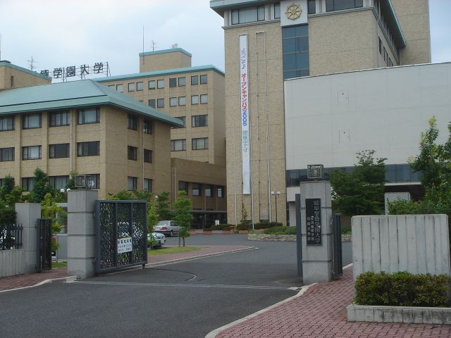
Gifu Shotoku Gakuen University
School · 5.5 km
Higher education institution in Gifu Prefecture, Japan


Museums and landmarks18


The Museum of Fine Arts, Gifu
Museum · 5.1 km
Art museum in Gifu, Gifu, Japan



6 more on the map.
Parks, trails and playgrounds22



10 more on the map.
Restaurants and cafes57


45 more on the map.
History
The area around Kasamatsu was part of traditional Owari Province until the course of the Kiso River shifted in 1586, after which time it was part of Mino Province. It was an ancient settlement on the important river crossing connecting Nagoya with Gifu. During the Edo period, it was mostly tenryō territory controlled by Tokugawa shogunate through a bugyō. During the post-Meiji restoration cadastral reforms, the area was organised into Haguri District, Gifu Prefecture, which was subsequently transferred to Hashima District, Gifu. The modern town of Kasamatsu was formed on July 1, 1889. In expanded by annexing the neighbouring village of Matsueda on August 1, 1950, and the village of Shimoharugi on April 1, 1955. Plans to merge with the neighbouring city of Gifu were rejected by a referendum in June 2004.
From the History section of Kasamatsu, Gifu on Wikipedia, under CC BY-SA 4.0.
Where to stay1
Churches and places of worship7
Shopping15
Gas and EV charging10
Schools, colleges and libraries22
Healthcare15
Map of Kasamatsuchō
171 places. The map loads OpenStreetMap tiles when you open it.
Getting there and nearby towns
Gifu Airbase (QGU) is the nearest airport with scheduled flights listed in OpenStreetMap, 10 km away.
- Gifu 6 km north, about 6 min by car
- Ichinomiya 8 km south, about 8 min by car
- Kōnan 10 km east, about 10 min by car
- Kakamigahara 11 km northeast, about 11 min by car
- Kitagata 11 km northwest, about 11 min by car
- Inazawa 13 km south, about 13 min by car
- Iwakura 13 km southeast, about 13 min by car
- Ōguchi 13 km east, about 13 min by car
- Ōgaki 14 km west, about 14 min by car
- Komaki 16 km southeast, about 16 min by car
Drive times are estimates from straight-line distance, not routes.
Local news
Headlines from INDB.
Reviews, tips and questions
Loading what members have shared...
Sources and licences
- GeoNames (CC BY 4.0): population, coordinates, regions and time zone
- OpenStreetMap contributors (ODbL 1.0): places, airports, map data
- Wikidata (CC0 1.0): elevation, founding date, time zone, website, landmarks and historic places
- Wikimedia Commons (see each image): photos
- Wikipedia (CC BY-SA 4.0): overview and history text
Photo credits
- Kasamatsucho-Yakuba01, Monami, CC BY-SA 3.0
- アクア・トトぎふ 外観, 世界淡水魚園水族館, CC BY-SA 4.0
- Gifu City Science Museum 1, Hide-sp, CC BY-SA 3.0
- THE MUSEUM OF FINE ARTS,GIFU 1, Hide-sp, CC BY-SA 3.0
- Apita kisogawa, ハヤカワ, Public domain
- Aeon yanaizu, Opqr, CC BY-SA 4.0
- Ohmatsu Art Museum01, Monami, CC BY-SA 3.0
- Ginantyou rekisiminzoku siryoukan, Opqr, CC BY-SA 3.0
- Ginankitasyou, Opqr, CC BY-SA 3.0
- Ginan Junior High School2008-1, Monami, CC BY-SA 3.0
- Yanaidu syougakkou, Opqr, CC BY-SA 3.0
- 岐阜市立茜部小学校, Opqr, CC BY-SA 4.0
- Seibikougennkan, nsi, CC BY-SA 3.0
- Simo-haguri elementary school, Kasamatsu, 2015, 大野 一将, CC BY-SA 4.0
- Matsueda elementary school, Kasamatsu, 2015, 大野 一将, CC BY-SA 4.0
- 岐阜市立鶉小学校, Opqr, CC BY-SA 4.0
- Bairinpark, Douggers at English Wikipedia, CC BY 2.5
- Gifu Shotoku Gakuen University1, The original uploader was Monami at Japanese Wikipedia ., CC BY-SA 3.0
- Kasamatsu Town Shimohaguri Elementary School ac, Asturio Cantabrio, CC BY-SA 4.0
- Ichinomiya City Kisogawa Nishi Elementary School, Psjk2106, CC BY-SA 4.0
- Ichinomiya City Kisogawa Middle School, Psjk2106, CC BY-SA 4.0
- Ichinomiya City Gyokudo Memorial Kisogawa Library 2020-10 ac (1), Asturio Cantabrio, CC BY-SA 4.0
- 岐阜県羽島郡笠松町(駐車場入り口) - panoramio, gundam2345, CC BY 3.0
- 笠松町の駐車場 - panoramio, gundam2345, CC BY 3.0
- 岐阜県羽島郡笠松町(桜並木) - panoramio, gundam2345, CC BY 3.0
- 岐阜県羽島郡笠松町若葉町(笠松春まつり臨時駐車場) - Panoramio 34269053, gundam2345, CC BY 3.0
- 2021-11-20 Sunset Train, シュポじ(ししまる), CC0
- 羽島郡笠松町上本町(だるまや薬局前) - panoramio, gundam2345, CC BY 3.0
- Gifu City Livestock Center, Earthbound1960, CC0
- 岐阜県羽島郡笠松町 - panoramio - gundam2345, gundam2345, CC BY 3.0
- 岐阜県羽島郡笠松町八幡町 - panoramio, gundam2345, CC BY 3.0
- 岐阜県羽島郡笠松町八幡町 - panoramio - gundam2345, gundam2345, CC BY 3.0
- 羽島郡笠松町八幡町 - panoramio, gundam2345, CC BY 3.0
- 柿本神社 - panoramio - gundam2345, gundam2345, CC BY 3.0
- 羽島郡笠松町上本町 - panoramio, gundam2345, CC BY 3.0
- 岐阜県羽島郡笠松町 - panoramio, gundam2345, CC BY 3.0
- 岐阜県羽島郡笠松町 - panoramio - gundam2345 (1), gundam2345, CC BY 3.0
- Shōun Inari, Kasamatsu Racecource 勝運稲荷 Oct 26, 2013 (2), Yuya Tamai, CC BY 2.0
- Shōun Inari, Kasamatsu Racecource 勝運稲荷 Oct 26, 2013 (1), Yuya Tamai, CC BY 2.0
- 2004.4.29 Mitsuaki Turbine, D.herios, CC BY-SA 4.0


Page built November 4, 2026. Spotted a mistake? Tell us or suggest a place.