


Kawagoe, Japan
川越市
Kawagoe is a town of 354,571 people in Saitama, Japan, founded in April 1, 1889.
Why visit Kawagoe
Townapedia lists 73 museums and landmarks, 32 parks and trails, 284 places to eat, 8 places to stay and 9 attractions in and around town.
Highlights include Bunri University of Hospitality, Kagawa Nutrition University, Kawagoe Festival Museum and Mizuko Shell Mound.
Weather in Kawagoe
Forecast from MET Norway (CC BY 4.0). Full forecast
About Kawagoe
Kawagoe (川越市, Kawagoe-shi) is a city in Saitama Prefecture, Japan. As of 1 February 2021, the city had an estimated population of 353,214 in 162,210 households and a population density of 3200 persons per km2. The total area of the city is 109.13 square kilometres (42.14 sq mi). The city is known locally as "Little Edo" (小江戸, Koedo) after the old name for Tokyo, due to its many historic buildings.
From the Wikipedia article Kawagoe, Saitama (this version), under CC BY-SA 4.0.
Travel tips from other travellers: Kawagoe on Wikivoyage (CC BY-SA 4.0).
Things to do9

Bunri University of Hospitality
School · 6.3 km
Higher education institution in Saitama Prefecture, Japan

Kagawa Nutrition University
School · 8.3 km
Private university in Japan with campuses in Saitama Prefecture and Tokyo
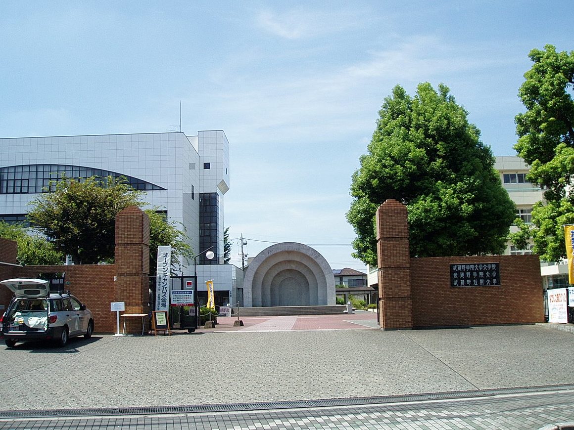
Musashino Gakuin University
School · 10.0 km
Higher education institution in Saitama Prefecture, Japan

Seigakuin University
School · 10.5 km
Higher education institution in Saitama Prefecture, Japan


Toho College of Music
School · 3.7 km
Private university in Tokyo, Japan

Tokyo International University
School · 4.7 km
Private university in Tokyo, Japan

Museums and landmarks73


Mizuko Shell Mound
Monument and historic site · 9.8 km
Shell midden, settlement in Saitama, Japan

Tōyama Memorial Museum
Museum · 8.8 km
Museum in Kawajima, Saitama, Japan




Kawagoe Ichibangai shopping street - Warehouse District
Monument and historic site · 1.7 km
61 more on the map.
Parks, trails and playgrounds32




20 more on the map.
Restaurants and cafes284


二代目笑堂
Restaurant · Japanese, Chinese · 1.2 km
World famous ramen group Owner is an entertainer and it is super interesting There is a DJ booth
8, 川越市
11:30-22:00

LUCKRUSH
Bar and pub · Japanese
12一3
Mo-We 18:00-03:00; Th 18:00-01:00; Fr-Sa 12:00-15:00, 18:00-02:00

272 more on the map.
History
Kawagoe is part of ancient Musashi Province. In the medieval period, the Kawagoe area was associated with the Uesugi and Hōjō clans. Kawagoe Castle was built in 1457 by Ōta Dōshin and Ōta Dōkan on behalf of Uesugi Mochitomo, and the castle and surrounding area later came under Hōjō control. In the 1450s, Kawagoe was held by the Yamanouchi branch of the Uesugi Clan. Decades later, Hōjō Ujitsuna seized Kawagoe Castle in 1537, and the city served as an important base of operations when the Later Hōjō clan sought to gain control of the Kantō. For roughly two decades after that, the Uesugi launched a number of attempts to regain the region. This culminated in the 1545 Battle of Kawagoe, as the heavily outnumbered Hōjō garrison of Kawagoe defeated an attempted siege of Kawagoe Castle. This victory would lead to the end of Uesugi power in the region, and the near-total destruction of the clan. The Hōjō having secured themselves in the region, Kawagoe served for another forty-five years as a satellite castle town defending Edo, and the clan's central castle at Odawara. Kawagoe's location on the Arakawa River and near the Edo River were important elements of its tactical significance in defending the Kantō region from potential attacks from the north.
From the History section of Kawagoe, Saitama on Wikipedia, under CC BY-SA 4.0.
Where to stay8
Churches and places of worship62
Shopping56
Gas and EV charging5
Schools, colleges and libraries21
Healthcare28
Map of Kawagoe
250 places. The map loads OpenStreetMap tiles when you open it.
Getting there and nearby towns
Yokota Air Base (OKO) is the nearest airport with scheduled flights listed in OpenStreetMap, 22 km away.
- Tokorozawa 12 km south, about 12 min by car
- Nishi-Tokyo-shi 21 km south, about 21 min by car
- Kokubunji 23 km south, about 23 min by car
- Kawaguchi 23 km southeast, about 23 min by car
- Musashino 23 km south, about 23 min by car
- Kazo 25 km northeast, about 25 min by car
- Ōme 26 km southwest, about 26 min by car
- Kumagaya 27 km north, about 27 min by car
- Koshigaya 27 km east, about 27 min by car
- Tokyo 31 km southeast, about 31 min by car
Drive times are estimates from straight-line distance, not routes.
Local news
Headlines from INDB.
Reviews, tips and questions
Loading what members have shared...
Sources and licences
- GeoNames (CC BY 4.0): population, coordinates, regions and time zone
- OpenStreetMap contributors (ODbL 1.0): places, airports, map data
- Wikidata (CC0 1.0): elevation, founding date, time zone, website, landmarks and historic places
- Wikimedia Commons (see each image): photos
- Wikipedia (CC BY-SA 4.0): overview and history text
Photo credits
- Kurazukuri Street in Little Edo, Dandy1022, CC BY-SA 4.0
- Kawagoe Station from above east exit Nov 15 2020 03-11PM, Nesnad, CC BY 4.0
- Atre Kawagoe at night, Tyuvc, CC BY-SA 3.0
- Kawagoe Station east entrance 20160320, DAJF, CC BY-SA 4.0
- Kawagoe stn east exit - Jan 19 2018, nesnad, CC BY 3.0
- Kawagoe station east exit, Tyuvc This photo was taken with Nexus 5, CC BY-SA 3.0
- JR Kawagoe - panoramio, kcomiida, CC BY-SA 3.0
- Sumitomo Mitsui Banking Corporation Kawagoe Branch, Suikotei, CC BY 4.0
- TJ Liner ticket machine Kawagoe Station 20160331, DAJF, CC BY-SA 4.0
- Kawagoe Station Tobu concourse 20160223, DAJF, CC BY-SA 4.0
- Kawagoe Station tobutojo line platform 1 - Nov 15 2020 various 16 11 34 904000, Nesnad, CC BY 4.0
- Tobu Kawagoe 20161223, 小田原 (Odawara), CC BY-SA 4.0
- Kawagoe Station tobutojo line platform 1 - Nov 15 2020 various 16 12 04 917000, Nesnad, CC BY 4.0
- Kawagoe Station tobutojo line platform 1 - Nov 15 2020 various, Nesnad, CC BY 4.0
- Kawagoe city tourist office, Tyuvc, CC BY-SA 3.0
- Kawagoe Station Tobutojo line platform 2 Nov 15 2020 various 16 17 45 033000, Nesnad, CC BY 4.0
- 51095 TJ Liner 4 Kawagoe Station 20160331, DAJF, CC BY-SA 4.0
- Kawagoe stn - tobu tojo ticket gates- Jan 19 2018, nesnad, CC BY-SA 3.0
- Kawagoe Station Tobutojo line platform 2 Nov 15 2020 various 16 17 25 465000, Nesnad, CC BY 4.0
- JR Kawagoe Station (38143460121), Kzaral, CC BY 2.0
- Tobu-Kawagoe-st-gate, E231-Tobucchi, Public domain
- Kawagoe Station Monju soba 20160223, DAJF, CC BY-SA 4.0
- 51094 TJ Liner 1 Kawagoe 20080624, DAJF, CC BY-SA 3.0
- Kawagoe Station JR ticket barriers 20160223, DAJF, CC BY-SA 4.0
- Kawagoe Station JR ticket machines 20160223, DAJF, CC BY-SA 4.0
- Kawagoe Dashi, Emmanuel Bastien, CC BY-SA 3.0
- Tobu 51092 Kawagoe 20080726, DAJF, CC BY-SA 3.0
- JR-Kawagoe-st-gate, E231-Tobucchi, Public domain
- Kawagoe Station tobutojo line platform 1 - Nov 15 2020 various 16 11 47 277000, Nesnad, CC BY 4.0
- Kawagoe Station 20160212, DAJF, CC BY-SA 4.0
- Kawagoe stn west exit taxis - Jan 19 2018, nesnad, CC BY 3.0
- Kawagoe Station West exit 20120608, DAJF, CC BY-SA 3.0
- Kawagoe stn west exit - Jan 19 2018, nesnad, CC BY 3.0
- Kawagoe Station west exit 20140328, DAJF, CC BY-SA 3.0
- Kawagoe Station 20100429, Kzaral, CC BY 2.0
- Bunri University of Hospitality, Abasaa, Public domain
- Kagawa Nutrition University (Joshi Eiyō Daigaku), Mj-bird, CC BY-SA 4.0
- Musashino-Gakuin-Univ-MainGate01, Hasec, CC0
- Shobi-Univ-20120901, Hasec, CC0
- Toho College of Music Kawagoe Campus, Abasaa, Public domain
- Tokyo International University campus1, TIU kouhou, CC BY-SA 3.0
- Fujimi Mizukokaiduka Park 3, 京浜にけ (Keihin-Nike), CC BY-SA 3.0
- The Toyama Memorial Museum 2015-2, PekePON, CC BY-SA 4.0
- Kawagoe Athletics Stadium-1 edited-1, Chiba ryo, CC BY-SA 3.0
- Kawagoe Kitain Main Hall 202011, tak1701d, CC BY-SA 3.0
- Atre Kawagoe, Abasaa, Public domain
- Semba-Toshogu, Abasaa, Public domain
- Kawagoe Girls High School, Abasaa, Public domain
- Kawagoe Technical High School, Abasaa, Public domain
- Kawagoe Comprehensive High School, Abasaa, Public domain
- Saitama Prefectural Kawagoe High School, Abasaa, Public domain
- Kawagoe Festival Museum, Abasaa, Public domain
- Kawagoe Kuratsukuri Museum, Abasaa, Public domain
- NaritasanKawagoeBetsuin20131014, 三人日, CC BY-SA 4.0
- Kawagoe Hie Shrine 201711, Tak1701d, CC BY-SA 3.0
- Q86496833, Vanbasten 23, CC BY-SA 3.0
- Hon-Kawagoe Station east 20160223, DAJF, CC BY-SA 4.0
- Old Yamazaki villa 02, 妖精書士, CC0
- 長喜院 Chōkiin, Kawagoe 2019-12-21, Wei-Te Wong from Taipei City, Taiwan, Republic of China, CC BY-SA 2.0
- 熊野神社拝殿 川越市 2019-12-21, Wei-Te Wong from Taipei City, Taiwan, Republic of China, CC BY-SA 2.0
- Q134736681, Vanbasten 23, CC BY-SA 3.0
- Seigakuin-Univ20160927, Keawbunroung, CC BY-SA 4.0


Page built November 4, 2026. Spotted a mistake? Tell us or suggest a place.