


Nishi-Tokyo-shi, Japan
西東京市
Nishi-Tokyo-shi is a town of 207,388 people in Tokyo, Japan, founded in January 21, 2001.
Why visit Nishi-Tokyo-shi
Townapedia lists 30 museums and landmarks, 139 parks and trails, 212 places to eat, 2 places to stay and 18 attractions in and around town.
Highlights include International Christian University, Japan College of Social Work, Tamarokuto Science Center and Edo-Tokyo Open Air Architectural Museum.
Weather in Nishi-Tokyo-shi
Forecast from MET Norway (CC BY 4.0). Full forecast
About Nishi-Tokyo-shi
Nishitokyo (西東京市, Nishitōkyō-shi; "City of West Tokyo") (Japanese pronunciation: [ɲiɕi̥toꜜːkʲoː]) is a city located in the western portion of Tokyo Metropolis, Japan. As of 1 January 2021, the city had an estimated population of 206,047, and a population density of 13,000 persons per km2. The total area of the city is 15.75 square kilometres (6.08 sq mi).
From the Wikipedia article Nishitokyo (this version), under CC BY-SA 4.0.
Travel tips from other travellers: Nishi-Tokyo-shi on Wikivoyage (CC BY-SA 4.0).
Things to do18

International Christian University
School · 4.3 km
University in Tokyo
Japan College of Social Work
School · 5.4 km
Private university in Tokyo, Japan

Japan Lutheran College
School · 4.1 km
Private university in Tokyo, Japan
Nippon Veterinary and Life Science University
School · 2.7 km
Private university in Tokyo

Seikei University
School · 3.5 km
Private university centered in Tokyo, Japan

Tokyo University of Foreign Studies
School · 5.9 km
Universities and colleges in Tokyo



6 more on the map.
Museums and landmarks30


Kodaira Hirakushi Denchu Art Museum
Museum · 5.7 km
Art museum in Tokyo, Japan

Shitanoya Site
Monument and historic site · 2.1 km
Archaeological site in Tokyo, Japan


Suzuki Site
Monument and historic site · 3.8 km
Archaeological site in Kodaira, Japan


18 more on the map.
Parks, trails and playgrounds139



Higashikurumeshi Chikurin Park
Park · 3.3 km
Park in Higashikurume, Japan

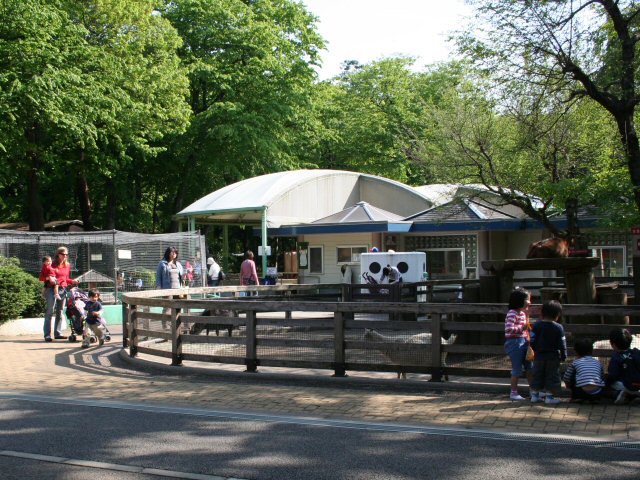


127 more on the map.
Restaurants and cafes212

Bokkakyo
Restaurant · Chinese
1, 西東京市
Mo off; Tu-Su,PH 11:30-15:00,17:00-20:00 || "Tu(next to PH) off"



21 Cave Brew - West Tokyo Brewing
Bar and pub · 2.1 km
7, 西東京市
Tu off
200 more on the map.
History
The area of present-day Nishitokyo was part of ancient Musashi Province. In the post-Meiji Restoration cadastral reform of July 22, 1878, the area became part of Kitadachi District in Saitama Prefecture. The villages of Hoya and Tanashi were created on April 1, 1889, with the establishment of modern municipalities system. The southern portion of Kitaadachi District was transferred to the administrative control of Tokyo Metropolis on April 1, 1907.
The city of Nishitokyo was established on January 21, 2001, by the merger of the cities of Hoya and Tanashi.
From the History section of Nishitokyo on Wikipedia, under CC BY-SA 4.0.
Where to stay2
Churches and places of worship23
Shopping57
Gas and EV charging5
Schools, colleges and libraries62
Healthcare50
Map of Nishi-Tokyo-shi
250 places. The map loads OpenStreetMap tiles when you open it.
Getting there and nearby towns
Yokota Air Base (OKO) is the nearest airport with scheduled flights listed in OpenStreetMap, 17 km away.
- Tokyo 14 km east, about 14 min by car
- Aihara 24 km southwest, about 24 min by car
- Kawasaki 28 km southeast, about 28 min by car
- Yamato 29 km south, about 29 min by car
- Zama 30 km southwest, about 30 min by car
- Sagamihara 32 km southwest, about 32 min by car
- Yokohama 34 km south, about 34 min by car
- Matsudo 33 km east, about 33 min by car
- Atsugi 35 km southwest, about 35 min by car
- Nagareyama 36 km northeast, about 36 min by car
Drive times are estimates from straight-line distance, not routes.
Local news
Headlines from INDB.
Reviews, tips and questions
Loading what members have shared...
Sources and licences
- GeoNames (CC BY 4.0): population, coordinates, regions and time zone
- OpenStreetMap contributors (ODbL 1.0): places, airports, map data
- Wikidata (CC0 1.0): elevation, founding date, time zone, website, landmarks and historic places
- Wikimedia Commons (see each image): photos
- Wikipedia (CC BY-SA 4.0): overview and history text
Photo credits
- Nishitokyo city hall Tanashi building, Altomarina, CC BY-SA 3.0
- ルーテル学院チャペル外観, ルーテル学院大学, CC BY-SA 3.0
- Jyuuitikusanuniv, The original uploader was Hykw-a4 at Japanese Wikipedia ., CC BY-SA 3.0
- Seikei Gakuen Main Building, Kakidai, CC BY-SA 4.0
- Tokyokeizaiuniv, Original uploader was Hykw-a4 at ja.wikipedia, CC BY-SA 3.0
- 東京外国語大学 - panoramio (16), kanesue, CC BY 3.0
- TWCU Main Building2023, Charlie fong, CC BY-SA 4.0
- Tsudajukuuniv, The original uploader was Hykw-a4 at Japanese Wikipedia ., CC BY-SA 3.0
- Tokyo Union Theological Seminary, Evangelical, CC BY-SA 3.0
- Entrance of the Edo-Tokyo Open Air Architectural Museum, Fumiya Fujihara, CC BY 2.0
- Kodaira Hirakushi Denchu Art Museum front, Calton, CC BY-SA 4.0
- Suginami kaikan suginami animation museum 2009, Kamemaru2000, CC BY-SA 3.0
- Suzuki Remains Museum, Nyao148, CC BY-SA 3.0
- Koganei-Park, Itasan, CC BY 3.0
- Chikurin Park in Higashikurume-shi (50547377101), Mikhail Kotykhov from Tokyo, Japan, CC BY 2.0
- Cherry blossoms at Inokashira Park, Fizzerfung, CC BY-SA 4.0
- Inokasira-sizen-bunkaen, No machine-readable author provided. Kazubon~commonswiki assumed (based on copyright claims)., Public domain
- Jindai Plants Park 2, ITA-ATU, CC BY-SA 3.0
- Makino Memorial Garden entrance 2013-11-24, Asanagi, CC0
- Musashinonomori Park 2, っ, CC BY-SA 3.0
- 武蔵関公園「富士見池」(中之橋から北東ボート乗り場方面)練馬区, Guy-aan, CC BY-SA 4.0
- Nerima Syakujii park sampoji pond, Ribbon, CC BY-SA 3.0
- Tonogayato1, Irina Gelbukh, CC BY-SA 3.0
- Asia-University-Japan, The original uploader was Itasan at Japanese Wikipedia ., CC BY-SA 3.0
- Ariake Campus, Musashino University, Kakidai, CC BY-SA 4.0
- Shimonoya iseki park, 妖精書士, CC0
- Musashino Joshi Gakuin, Douglas P. Perkins, CC BY 3.0
- SkyTower NishiTokyo, Kakidai, CC BY-SA 3.0
- Sassa General Hospital 20130503, Waka77, Public domain
- 多摩六都科学館, Fujie0511, CC BY-SA 4.0
- Musashino 2nd Junior High-School, ITA-ATU, Public domain
- Tanashi jinja3, 江戸村のとくぞう (Edomura no Tokuzo), CC BY-SA 4.0
- Souji-ji1, 江戸村のとくぞう (Edomura no Tokuzo), CC BY-SA 4.0
- Hojuin hondo, 河太郎, CC BY-SA 4.0
- Jodonojinja, 河太郎, CC BY-SA 4.0
- Nyoirinji hondo, 河太郎, CC BY-SA 4.0
- Tozenji hondo, 河太郎, CC BY-SA 4.0
- Hokoin sanmon, 河太郎, CC BY-SA 4.0
- Shinmeisya shrine Higashikurume Tokyo, Mizushimasea, CC BY-SA 4.0
- Enjo-in (Kodaira), Abasaa, Public domain
- Kaetsu univ, high190, CC BY 3.0
- 東京都立武蔵高等学校・附属中学校, SANDO, CC BY-SA 3.0
- Musashino 5th Primary School, ITA-ATU, CC BY-SA 3.0
- Ghibli Museum, Mitaka - panoramio, Tomi Mäkitalo, CC BY-SA 3.0


Page built November 4, 2026. Spotted a mistake? Tell us or suggest a place.