
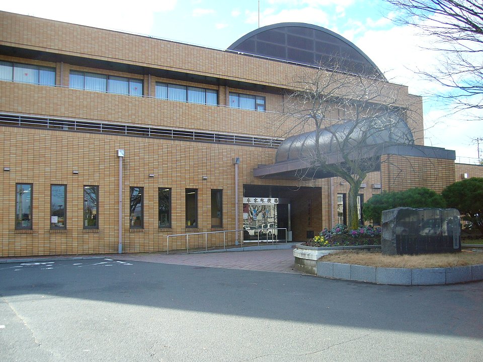


Motomiya, Japan
本宮市
Motomiya is a town of 30,236 people in Fukushima, Japan, founded in January 1, 2007.
Why visit Motomiya
Townapedia lists 6 museums and landmarks, 5 parks and trails, 33 places to eat, 1 place to stay and 8 attractions in and around town.
Highlights include Ohu University, 本宮映画劇場, Nihomatsu Domain Monumental Stele and Obama Castle.
Weather in Motomiya
Forecast from MET Norway (CC BY 4.0). Full forecast
About Motomiya
Motomiya (本宮市, Motomiya-shi) is a city located in north-central Fukushima Prefecture, Japan. As of 1 March 2020, the city had an estimated population of 30,401 in 10,680 households and a population density of 350 persons per km2. The total area of the city was 88.02 square kilometres (33.98 sq mi). It is the smallest city in Fukushima Prefecture, both in terms of population and size.
From the Wikipedia article Motomiya, Fukushima (this version), under CC BY-SA 4.0.
Things to do8

Ohu University
School · 10.9 km
Higher education institution in Fukushima Prefecture, Japan


Museums and landmarks6

Nihomatsu Domain Monumental Stele
Monument and historic site · 9.8 km
Stele in Fukushima, Japan

Obama Castle
Monument and historic site · 10.0 km
Mountain castle in Japan


Parks, trails and playgrounds5






Restaurants and cafes33



21 more on the map.
History
The area of present-day Motomiya was part of ancient Mutsu Province. The oldest known record refers to the area of Motomiya as "Honmoku" (本牧). Later in the Nara period, the characters for Honmoku were rewritten as (本目), also pronounceable as Motome. Motome was then rewritten as (木目). Then in the 11th century, it became the current Motomiya (本宮). The origins of the name Motomiya, literally meaning "Central Shrine," refer to the Adatara Jinja (安達太良神社), a Shinto shrine in the city's northern district.
As a starting point for roads to Aizu, Miharu, Sōma, and many other destinations, Motomiya became well known as an inn town. In addition, with the growth of lesser roads to Aizu, Adachi no Umaya (安達駅), a government-maintained rest stop and messenger station, was established in Motomiya. Currently, the stone marker indicating the start of the Aizu road is preserved at the Motomiya City Historical Folk Museum. Date Masamune (伊達政宗) used Motomiya as a base during the Battle of Hitotoribashi (人取橋の戦い). Afterwards during the Edo period Tokugawa shogunate, Motomiya was part of the holding of Nihonmatsu Domain. During the Boshin War a number of battles were fought within the city limits.
From the History section of Motomiya, Fukushima on Wikipedia, under CC BY-SA 4.0.
Where to stay1
Churches and places of worship14
Shopping7
Gas and EV charging3
Schools, colleges and libraries10
Healthcare9
Map of Motomiya
96 places. The map loads OpenStreetMap tiles when you open it.
Getting there and nearby towns
Fukushima Airport (FKS) is the nearest airport with scheduled flights listed in OpenStreetMap, 32 km away.
- Kōriyama 13 km south, about 13 min by car
- Sukagawa 26 km south, about 26 min by car
- Fukushima 27 km north, about 27 min by car
- Yabuki 36 km south, about 36 min by car
- Aizu-Wakamatsu 40 km west, about 40 min by car
- Yanagawamachi-saiwaichō 41 km northeast, about 41 min by car
- Kitakata 49 km west, about 49 min by car
- Namie 53 km east, about 53 min by car
- Tanagura 54 km south, about 54 min by car
- Nasushiobara 67 km southwest, about 1 h by car
Drive times are estimates from straight-line distance, not routes.
Local news
Headlines from INDB.
Reviews, tips and questions
Loading what members have shared...
Sources and licences
- GeoNames (CC BY 4.0): population, coordinates, regions and time zone
- OpenStreetMap contributors (ODbL 1.0): places, airports, map data
- Wikidata (CC0 1.0): elevation, founding date, time zone, website, landmarks and historic places
- Wikimedia Commons (see each image): photos
- Wikipedia (CC BY-SA 4.0): overview and history text
Photo credits
- Motomiya town-office, Bakkai at Japanese Wikipedia, CC BY-SA 3.0
- Motomiya station001, Vanquish0, CC BY-SA 4.0
- Motomiya Station East Exit View 2021-12-20, Rory trains, CC BY-SA 4.0
- Motomiya Station East Exit 2021-12-20, Rory trains, CC BY-SA 4.0
- Motomiya station december2012 2, マルタ12, CC BY-SA 3.0
- Motomiya station december2012 1, マルタ12, CC BY-SA 3.0
- Motomiya Station New Station building Connecting passage from East side 2021-12-2, Rory trains, CC BY-SA 4.0
- Motomiya Station building Piano 2021-12-20, Rory trains, CC BY-SA 4.0
- Motomiya Station Old Station building 2021-12-20, Rory trains, CC BY-SA 4.0
- Motomiya Station platform for Fukushima 2021-12-20, Rory trains, CC BY-SA 4.0
- Motomiya Station platform for Kōriyama 2021-12-20, Rory trains, CC BY-SA 4.0
- Motomiya Station Ticket gate 2021-12-20, Rory trains, CC BY-SA 4.0
- Motomiya Station West Exit View 2021-12-20, Rory trains, CC BY-SA 4.0
- Motomiya Station New Station building Connecting passage from West side 2021-12-2, Rory trains, CC BY-SA 4.0
- Motomiya Station West Exit 2021-12-20, Rory trains, CC BY-SA 4.0
- Motomiya Station Automatic ticket vending machine 2021-12-20, Rory trains, CC BY-SA 4.0
- Nihonmatsu Domain Kaisekimei-hi 01, Suikotei, CC BY-SA 4.0
- 小浜城石垣, ddsg, Public domain
- 蛇の鼻御殿 入口付近から, Sugikats, CC BY-SA 4.0
- RZ Motomiya Eiga Gekijo (1), Razgrad, CC BY-SA 4.0
- Ohu University 01, あばさー, Public domain
- Mizuiro-park, Ndwebfe0w, CC BY-SA 4.0
- 安達太良神社 - panoramio, Duff Figgy, CC BY-SA 3.0
- 本宮駅旧駅舎 2021-12-20, Rory trains This photo was taken with iPhone 12 Mini, CC BY-SA 4.0
- 日輪寺 - panoramio, Duff Figgy, CC BY-SA 3.0
- 日輪寺供養塔 - panoramio, Duff Figgy, CC BY-SA 3.0
- 日輪寺の枝垂桜 - panoramio, Duff Figgy, CC BY-SA 3.0
- 本宮カボチャ会 - panoramio, Duff Figgy, CC BY-SA 3.0
- 除染作業 福島県本宮市上山田地区 Jul 28, 2014 (1), Atsushi Boulder, CC BY-SA 2.0
- ISS040-E-8124 - View of Earth, Earth Science and Remote Sensing Unit , Lyndon B. Johnson Space Center, Public domain
- ISS027-E-5291 - View of Japan, Earth Science and Remote Sensing Unit , Lyndon B. Johnson Space Center, Public domain
- Adatara-SA-Nobori, D700master, CC BY-SA 3.0


Page built November 4, 2026. Spotted a mistake? Tell us or suggest a place.