
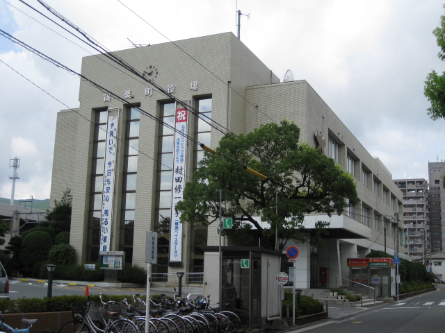


Sasaguri, Japan
篠栗町
Sasaguri is a town of 31,213 people in Fukuoka, Japan, founded in April 1, 1889.
Why visit Sasaguri
Townapedia lists 7 museums and landmarks, 4 parks and trails, 18 places to eat, 5 places to stay and 6 attractions in and around town.
Highlights include 若杉山, Ae Kanga ruins and Daibu temple ruins.
Weather in Sasaguri
Forecast from MET Norway (CC BY 4.0). Full forecast
About Sasaguri
Sasaguri (篠栗町, Sasaguri-machi) is a town in Kasuya District, Fukuoka Prefecture, Japan. As of 31 March 2024, the town had an estimated population of 31,191 in 14041 households, and a population density of 250 persons per km². The total area of the town is 38.93 km2 (15.03 sq mi)
From the Wikipedia article Sasaguri, Fukuoka (this version), under CC BY-SA 4.0.
Things to do6


Museums and landmarks7

Ae Kanga ruins
Monument and historic site · 8.6 km
Archaeological site in Japan
Daibu temple ruins
Monument and historic site · 8.6 km
Temple ruins in Fukuoka, Japan


Mount Shura Site
Monument and historic site · 5.9 km
Archaeological site in Hisayama, Japan

Parks, trails and playgrounds4


Restaurants and cafes18



6 more on the map.
History
The area of Sasaguri was part of ancient Chikuzen Province. During the Edo Period, the area was under the control of Fukuoka Domain. After the Meiji restoration, the villages of Sasaguri and Seto were established with the creation of the modern municipalities system on April 1, 1889. The Sasaguri was raised to town status on January 1, 1927, and annexed Seto on April 1, 1955.
From the History section of Sasaguri, Fukuoka on Wikipedia, under CC BY-SA 4.0.
Where to stay5
Churches and places of worship21
Shopping3
Gas and EV charging5
Schools, colleges and libraries15
Healthcare10
Map of Sasaguri
94 places. The map loads OpenStreetMap tiles when you open it.
Getting there and nearby towns
Fukuoka Airport (FUK) is the nearest airport with scheduled flights listed in OpenStreetMap, 10 km away.
- Umi 6 km southwest, about 6 min by car
- Ōnojō 11 km southwest, about 11 min by car
- Fukuoka 13 km west, about 13 min by car
- Iizuka 13 km east, about 13 min by car
- Kasuga 13 km southwest, about 13 min by car
- Chikushino-shi 14 km south, about 14 min by car
- Shingū 16 km northwest, about 16 min by car
- Tachiarai 25 km south, about 25 min by car
- Kurume 33 km south, about 33 min by car
- Kitakyushu 38 km northeast, about 38 min by car
Drive times are estimates from straight-line distance, not routes.
Local news
Headlines from INDB.
Reviews, tips and questions
Loading what members have shared...
Sources and licences
- GeoNames (CC BY 4.0): population, coordinates, regions and time zone
- OpenStreetMap contributors (ODbL 1.0): places, airports, map data
- Wikidata (CC0 1.0): elevation, founding date, time zone, website, landmarks and historic places
- Wikimedia Commons (see each image): photos
- Wikipedia (CC BY-SA 4.0): overview and history text
Photo credits
- Sasaguri Town Office, ja:user: jihara19, Public domain
- Narufuchi Dam and Sasaguri Line, そらみみ (Soramimi), CC BY-SA 4.0
- Narufuchi Dam on Narufuchigawa River and Sasaguri Line, そらみみ (Soramimi), CC BY-SA 4.0
- Yamate Kannondo Hall in Sasaguri, Kasuya, Fukuoka, そらみみ (Soramimi), CC BY-SA 4.0
- Yamate Yakushido Hall in Sasaguri, Kasuya, Fukuoka, そらみみ (Soramimi), CC BY-SA 4.0
- Sasaguri Line and Ogawa Park, そらみみ (Soramimi), CC BY-SA 4.0
- Yamate Kannondo Hall in Sasaguri, Kasuya, Fukuoka 2, そらみみ (Soramimi), CC BY-SA 4.0
- Sasaguri Line near Chikuzen-Yamate Station, そらみみ (Soramimi), CC BY-SA 4.0
- Kongomon Gate and sculpture of Kukai of Akashidera Temple (Sasaguri), そらみみ (Soramimi), CC BY-SA 4.0
- Shinjiike Pond of Akashidera Temple (Sasaguri), そらみみ (Soramimi), CC BY-SA 4.0
- Taizomon Gate of Akashidera Temple (Sasaguri), そらみみ (Soramimi), CC BY-SA 4.0
- Mount Wakasugiyama from Sakado Station, そらみみ, CC BY-SA 4.0
- Syurasan iseki, Swordman0527, CC BY-SA 3.0
- Polyrhachis moesta, Jonghyun Park, CC BY 4.0
- Japan National Route 201 and Yakiyama Bypass near Chikuzen-Yamate Station, そらみみ (Soramimi), CC BY-SA 4.0
- Japan National Route 201 near Chikuzen-Yamate Station 2, そらみみ (Soramimi), CC BY-SA 4.0
- Japan National Route 201 near Chikuzen-Yamate Station 3, そらみみ (Soramimi), CC BY-SA 4.0
- View of Chikuzen-Yamate Station, そらみみ (Soramimi), CC BY-SA 4.0
- Narufuchi Dam from train of Fukuhoku Yutaka Line 2, そらみみ (Soramimi), CC BY-SA 4.0
- Yakiyama Bypass of Japan National Route 201 near Chikuzen-Yamate Station 2, そらみみ (Soramimi), CC BY-SA 4.0
- Narufuchi Dam from train of Fukuhoku Yutaka Line, そらみみ (Soramimi), CC BY-SA 4.0
- Japan National Route 201 near Chikuzen-Yamate Station, そらみみ (Soramimi), CC BY-SA 4.0
- View of Narufuchi Dam 20160520-1, そらみみ (Soramimi), CC BY-SA 4.0
- Chikuzen-Yamate Station 20160520-2, そらみみ (Soramimi), CC BY-SA 4.0
- Yakiyama Bypass of Japan National Route 201 near Chikuzen-Yamate Station, そらみみ (Soramimi), CC BY-SA 4.0
- View of Narufuchi Dam 20160520-2, そらみみ (Soramimi), CC BY-SA 4.0
- Chikuzen-Yamate Station 20160520-3, そらみみ (Soramimi), CC BY-SA 4.0
- Japan National Route 201 in front of Chikuzen-Yamate Station, そらみみ, CC BY-SA 4.0
- Platform of Chikuzen-Yamate Station, そらみみ (Soramimi), CC BY-SA 4.0
- Platform of Chikuzen-Yamate Station 2, そらみみ (Soramimi), CC BY-SA 4.0
- Yamate Community Center 20160520-2, そらみみ (Soramimi), CC BY-SA 4.0
- Narufuchi Dam and Ogawa Park, そらみみ (Soramimi), CC BY-SA 4.0
- Chikuzen-Yamate Station 20160520-1, そらみみ (Soramimi), CC BY-SA 4.0
- View from platform of Chikuzen-Yamate Station, そらみみ (Soramimi), CC BY-SA 4.0
- Ticket machine of Chikuzen-Yamate Station, そらみみ (Soramimi), CC BY-SA 4.0
- Platform of Chikuzen-Yamate Station 3, そらみみ (Soramimi), CC BY-SA 4.0
- View near Yamate Kannondo Hall, そらみみ (Soramimi), CC BY-SA 4.0
- View from platform of Chikuzen-Yamate Station 2, そらみみ (Soramimi), CC BY-SA 4.0
- Back view of Chikuzen-Yamate Station, そらみみ (Soramimi), CC BY-SA 4.0
- Yamate Community Center 20160520, そらみみ (Soramimi), CC BY-SA 4.0


Page built November 4, 2026. Spotted a mistake? Tell us or suggest a place.