


Umi, Japan
宇美町
Umi is a town of 39,772 people in Fukuoka, Japan, founded in April 1, 1889.
Why visit Umi
Townapedia lists 33 museums and landmarks, 44 parks and trails, 106 places to eat, 8 places to stay and 21 attractions in and around town.
Highlights include Chikushi Jogakuen University, Fukuoka International University, Ae Kanga ruins and Dazaifu Gakkōin Site.
Weather in Umi
Forecast from MET Norway (CC BY 4.0). Full forecast
About Umi
Umi (宇美町, Umi-machi) is a town located in Kasuya District, Fukuoka Prefecture, Japan. As of 31 March 2024, the town had an estimated population of 36,907 in 16691 households, and a population density of 1200 persons per km2. The total area of the town is 30.21 km2 (11.66 sq mi)
From the Wikipedia article Umi, Fukuoka (this version), under CC BY-SA 4.0.
Things to do21

Chikushi Jogakuen University
School · 6.6 km
Higher education institution in Fukuoka Prefecture, Japan
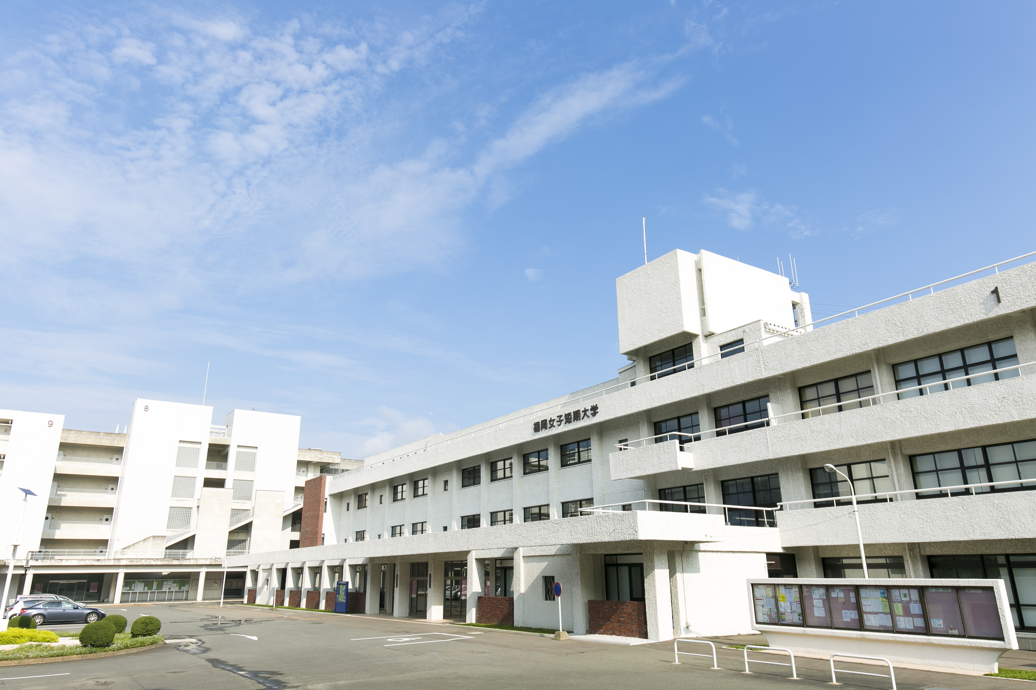
Fukuoka International University
School · 6.8 km
Higher education institution in Fukuoka Prefecture, Japan

Fukuoka Jo Gakuin University
School · 7.5 km
Higher education institution in Fukuoka Prefecture, Japan

Fukuoka Social Medical Welfare University
School · 7.0 km
Higher education institution in Fukuoka Prefecture, Japan

Japan University of Economics
School · 7.1 km
Higher education institution in Fukuoka Prefecture, Japan
Kyushu Institute of Design
School · 7.5 km
Higher education institution in Fukuoka Prefecture, Japan

Kyushu Institute of Information Sciences
School · 5.6 km
Higher education institution in Fukuoka Prefecture, Japan



9 more on the map.
Museums and landmarks33

Ae Kanga ruins
Monument and historic site · 7.0 km
Archaeological site in Japan

Dazaifu Gakkōin Site
Monument and historic site · 6.0 km
Historic university site in Fukuoka, Japan

Itazuke Site
Monument and historic site · 5.3 km
Archaeological site in Japan

Kanenokuma Site
Monument and historic site · 3.6 km
Archeological site in Hakata-ku, Fukuoka, Japan

Kokubu Tile Kiln ruins
Monument and historic site · 5.2 km
Archaeological site in Japan

Kyushu National Museum
Museum · 6.1 km
National museum in Fukuoka, Japan

Sugu-Okamoto Site
Monument and historic site · 6.5 km
Historic site in Kasuga, Fukuoka, Japan


21 more on the map.
Parks, trails and playgrounds44



32 more on the map.
Restaurants and cafes106


94 more on the map.
History
The area of Umi was part of ancient Chikuzen Province. According to the Nihon Shoki and Kojiki, this is the place where Empress Jingū gave birth to Emperor Ōjin on her way back from the conquest of Korea. During the Edo Period, the area was under the control of Fukuoka Domain. After the Meiji restoration, the village of Umi was established with the creation of the modern municipalities system on April 1, 1889. Umi was elevated to town status on October 20, 1920.
From the History section of Umi, Fukuoka on Wikipedia, under CC BY-SA 4.0.
Where to stay8
Churches and places of worship20
Shopping31
Gas and EV charging9
Schools, colleges and libraries45
Healthcare27
Map of Umi
250 places. The map loads OpenStreetMap tiles when you open it.
Getting there and nearby towns
Fukuoka Airport (FUK) is the nearest airport with scheduled flights listed in OpenStreetMap, 6 km away.
- Ōnojō 5 km southwest, about 5 min by car
- Kasuga 7 km southwest, about 7 min by car
- Chikushino-shi 8 km south, about 8 min by car
- Fukuoka 9 km west, about 9 min by car
- Iizuka 18 km northeast, about 18 min by car
- Kurume 28 km south, about 28 min by car
- Kitakyushu 45 km northeast, about 45 min by car
- Yanagawa 46 km south, about 46 min by car
- Yukuhashi 47 km east, about 47 min by car
- Karatsu 52 km west, about 52 min by car
Drive times are estimates from straight-line distance, not routes.
Local news
Headlines from INDB.
Reviews, tips and questions
Loading what members have shared...
Sources and licences
- GeoNames (CC BY 4.0): population, coordinates, regions and time zone
- OpenStreetMap contributors (ODbL 1.0): places, airports, map data
- Wikidata (CC0 1.0): elevation, founding date, time zone, website, landmarks and historic places
- Wikimedia Commons (see each image): photos
- Wikipedia (CC BY-SA 4.0): overview and history text
Photo credits
- Umi-Hachimangu shrine Fukuoka,JAPAN, Si-take. at Japanese Wikipedia This photo was taken with Olympus X-350 / D-575Z / C-360Z, CC BY-SA 3.0
- Warehouse and Treasure Hall of Umi Hachiman Shrine, そらみみ (Soramimi), CC BY-SA 4.0
- Umi Town Firefighting Hall in Umi, Kasuya, Fukuoka 20160726, そらみみ (Soramimi), CC BY-SA 4.0
- Stele of Umi Town Office, そらみみ (Soramimi), CC BY-SA 4.0
- Fukuoka Prefectural Road No.60 near Umi Town Office, そらみみ (Soramimi), CC BY-SA 4.0
- Umi-hommachi Post Office, Jkr2255, CC BY 3.0
- Shimmon Gate of Umi Hachiman Shrine from inner side, そらみみ, CC BY-SA 4.0
- Hondo of Shingyoji Temple in Umi, Kasuya, Fukuoka, そらみみ (Soramimi), CC BY-SA 4.0
- Kuri of Shingyoji Temple in Umi, Kasuya, Fukuoka, そらみみ (Soramimi), CC BY-SA 4.0
- Bell tower of Shingyoji Temple in Umi, Kasuya, Fukuoka, そらみみ (Soramimi), CC BY-SA 4.0
- View of Umi Hachiman Shrine near Shingyoji Temple, そらみみ (Soramimi), CC BY-SA 4.0
- Camphor trees in Umi Hachiman Shrine 3, そらみみ, CC BY-SA 4.0
- Umi Town History and Folklore Museum 20190118, そらみみ, CC BY-SA 4.0
- Umi Town History and Folklore Museum 20190118-2, そらみみ, CC BY-SA 4.0
- Kusumori Inari Shrine in Umi Hachiman Shrine 2, そらみみ, CC BY-SA 4.0
- Kusumori Inari Shrine in Umi Hachiman Shrine, そらみみ (Soramimi), CC BY-SA 4.0
- Emaden Hall of Umi Hachiman Shrine, そらみみ, CC BY-SA 4.0
- Walking street near Umi Hachiman Shrine, そらみみ, CC BY-SA 4.0
- Umi Town History and Folklore Museum 20190118-3, そらみみ, CC BY-SA 4.0
- Shaden of Umi Hachiman Shrine 2, そらみみ, CC BY-SA 4.0
- Yubuta no Mori Camphor Tree and Umi Hachiman Shrine, そらみみ (Soramimi), CC BY-SA 4.0
- Shimmon Gate of Umi Hachiman Shrine 2, そらみみ, CC BY-SA 4.0
- Yubuta no Mori Camphor Tree in Umi Hachiman Shrine 2, そらみみ (Soramimi), CC BY-SA 4.0
- Toriis of Umi Hachiman Shrine and Stele for Emperor Ojin's Birth 3, そらみみ, CC BY-SA 4.0
- Walking street near Umi Station, そらみみ, CC BY-SA 4.0
- Yubuta no Mori Camphor Tree and Umi Hachiman Shrine 2, そらみみ (Soramimi), CC BY-SA 4.0
- Emaden Hall of Umi Hachiman Shrine 2, そらみみ, CC BY-SA 4.0
- Ebisu Shrine in Umi Hachiman Shrine, そらみみ, CC BY-SA 4.0
- Tokinose (shop of wagashi) in Umi Hachiman Shrine, そらみみ (Soramimi), CC BY-SA 4.0
- Sculpture of horse and Yubuta no Mori Camphor Tree in Umi Hachiman Shrine, そらみみ (Soramimi), CC BY-SA 4.0
- Koyasu no Mori Forest of Umi Hachiman Shrine, そらみみ (Soramimi), CC BY-SA 4.0
- Shomo Shrine in Umi Hachiman Shrine, そらみみ, CC BY-SA 4.0
- Yubuta no Mori Camphor Tree in Umi Hachiman Shrine 1, そらみみ (Soramimi), CC BY-SA 4.0
- Shomo Shrine and Ebisu Shrine in Umi Hachiman Shrine, そらみみ (Soramimi), CC BY-SA 4.0
- Haiden of Umi Hachiman Shrine 4, そらみみ, CC BY-SA 4.0
- Umi Hachimangu 2014-08-23 (15019656135), yuki5287 from Fukuoka city, Japan, CC BY 2.0
- Takeuchi Shrine in Umi Hachiman Shrine, そらみみ (Soramimi), CC BY-SA 4.0
- Shimmon Gate of Umi Hachiman Shrine, そらみみ, CC BY-SA 4.0
- View of Umi Station, そらみみ, CC BY-SA 4.0
- Fukuoka Jo Gakuin University, Mattk1964, CC BY-SA 3.0
- 日本経済大学KOROKAN, Maria0402, CC BY-SA 4.0
- Dazaifu (government) gakko-in, Saigen Jiro, CC0
- Itazuke Ruins, Muyo, CC BY-SA 3.0
- Kokubu Kawaragama (Dazaifu), Saigen Jiro, CC0
- Kyushu National Museum 九州国立博物館 01, ノボホショコロトソ, CC BY 4.0
- Warehouses at the Suguokamoto Site, STA3816, CC BY-SA 4.0
- Umi-hachimangu ac (1), Asturio Cantabrio, CC BY-SA 4.0
- Level5 Stadium 02, Waka77, Public domain
- 博多の森陸上競技場, selection, CC BY 3.0
- AEON MALL FUKUOKA LUCLE, わたらせみずほ, CC BY-SA 3.0
- Platform of former Shime Station in Shime Railway Park, そらみみ (Soramimi), CC BY-SA 4.0
- Koshoji Kofun03, Muyo, CC BY-SA 4.0
- Tanabataike Kofun02, Muyo, CC BY-SA 4.0
- Umi Town History and Folklore Museum ac, Asturio Cantabrio, CC BY-SA 4.0
- 福岡女子短期大学, Katsutoshi Sakurai, CC BY-SA 4.0
- Chikushijogakuen University01, Muyo master at ja.wikipedia, CC BY-SA 3.0
- KIIS01, Muyo master at ja.wikipedia, CC BY-SA 3.0
- Mount Wakasugiyama from Sakado Station, そらみみ, CC BY-SA 4.0
- Kanenokuma jar coffins, MChew, CC BY-SA 4.0
- Onojo Ogi Elementary School 2006, Unknown author, CC BY-SA 3.0
- Onojo Shimoori Elementary School, hyolee2, CC BY-SA 4.0
- Sue High School, Hyolee2, CC BY-SA 4.0
- Shime Junior High School, hyolee2, CC BY-SA 4.0
- Fukuoka Tsukiguma Elementary School, hyolee2, CC BY-SA 4.0
- Fukuoka Higashitsukiguma Elementary School, hyolee2, CC BY-SA 4.0


Page built November 4, 2026. Spotted a mistake? Tell us or suggest a place.