
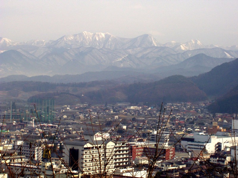


Tendō, Japan
天童市
Tendō is a town of 65,393 people in Yamagata, Japan, founded in April 1, 1889.
Why visit Tendō
Townapedia lists 17 museums and landmarks, 21 parks and trails, 277 places to eat, 27 places to stay and 6 attractions in and around town.
Highlights include Yamagata Prefectural University of Health Sciences, 舞鶴山, Dewazakura Museum of Art and Nishinumata ruins.
Weather in Tendō
Forecast from MET Norway (CC BY 4.0). Full forecast
About Tendō
Tendō (天童市, Tendō-shi) is a city located in Yamagata Prefecture, Japan. As of 1 February 2020, the city had an estimated population of 61,947 in 22392 households, and a population density of 550 persons per km2. The total area of the city is 113.01 square kilometres (43.63 square miles).
From the Wikipedia article Tendō, Yamagata (this version), under CC BY-SA 4.0.
Travel tips from other travellers: Tendō on Wikivoyage (CC BY-SA 4.0).
Things to do6
Yamagata Prefectural University of Health Sciences
School · 6.6 km
Higher education institution in Yamagata Prefecture, Japan



Museums and landmarks17


Nishinumata ruins
Monument and historic site · 2.5 km
Archaeological site in Japan

Shima ruins
Monument and historic site · 8.9 km
Japanese archaeological site
Yamagata Museum of Art
Museum · 11.3 km
Art museum in Yamagata, Yamagata, Japan



5 more on the map.
Parks, trails and playgrounds21



9 more on the map.
Restaurants and cafes277



265 more on the map.
History
During the Edo period, the area of present-day Tendō was part of Tendō Domain, a 20,000 koku feudal domain under the Tokugawa shogunate controlled by the Oda clan, who ruled from 1831 to 1871.
After the start of the Meiji period, the area organized as Tendō Village under Higashimurayama District, Yamagata Prefecture in 1878. It was elevated to town status on April 27, 1892 and became a city on October 1, 1958.
From the History section of Tendō, Yamagata on Wikipedia, under CC BY-SA 4.0.
Where to stay27
Churches and places of worship67
Shopping45
Gas and EV charging19
Schools, colleges and libraries30
Healthcare68
Map of Tendō
250 places. The map loads OpenStreetMap tiles when you open it.
Getting there and nearby towns
Yamagata Airport (GAJ) is the nearest airport with scheduled flights listed in OpenStreetMap, 6 km away.
- Murata 41 km southeast, about 41 min by car
- Takahata 42 km south, about 42 min by car
- Sendai 44 km east, about 44 min by car
- Tomiya 45 km east, about 45 min by car
- Shiroishi 45 km southeast, about 45 min by car
- Shinjō 45 km north, about 45 min by car
- Ōkawara 46 km southeast, about 46 min by car
- Natori-shi 49 km southeast, about 49 min by car
- Rifu 53 km east, about 53 min by car
- Tagajō-shi 55 km east, about 55 min by car
Drive times are estimates from straight-line distance, not routes.
Local news
Headlines from INDB.
Reviews, tips and questions
Loading what members have shared...
Sources and licences
- GeoNames (CC BY 4.0): population, coordinates, regions and time zone
- OpenStreetMap contributors (ODbL 1.0): places, airports, map data
- Wikidata (CC0 1.0): elevation, founding date, time zone, website, landmarks and historic places
- Wikimedia Commons (see each image): photos
- Wikipedia (CC BY-SA 4.0): overview and history text
Photo credits
- Tendō, edsnakahara, CC BY 2.0
- Shima iseki park 02, Yamagata, Suz-b, CC BY-SA 4.0
- Yamagata Museum of Art 2007, No machine-readable author provided. Crown of Lenten rose assumed (based on copyright claims)., Public domain
- Mogami Yoshiaki Historical Museum, Mogami Yoshiaki Historical Museum, CC BY-SA 3.0
- Yamagata Pref. Univ. of Health Sciences, Suz-b, CC BY-SA 3.0
- Dewazakura shuzo, Suz-b, CC BY-SA 3.0
- NDsoftstadium20090628, Waka77, Public domain
- 境内全景 佛向寺 天童市, Bomb55, CC BY-SA 4.0
- Tendo City Hospital, Ebiebi2, CC BY-SA 4.0
- Takeisao-jinja (Tendō city) haiden, Saigen Jiro, CC0
- Maiduruyama Tendou, Yamagata, Suz-b, CC BY-SA 3.0
- Tendo-onsen Shinoda hospital, Tendo, Suz-b, CC BY-SA 4.0
- Yamagata Prefectural Central Hospital, Bakkai, CC BY 3.0
- Tendo City Nishinumata Site Park, Mukasora ( talk ), CC BY-SA 3.0
- Takeisao shrine, Drivephotographer, CC0
- Human shogi board, Drivephotographer, CC0
- Tendo, Yamagata Prefecture 994-0000, Japan - panoramio (1), Fumihiko Ueno, CC BY 3.0
- Atago swamp, Drivephotographer, CC0
- Tendo, Yamagata Prefecture 994-0000, Japan - panoramio, Fumihiko Ueno, CC BY 3.0
- Tendo Station East Exit and Tendo City Shogi Museum, さかおり, CC BY-SA 4.0
- Tendo shogi museum, Drivephotographer, CC0
- Tendo Station 天童站 - panoramio, lienyuan lee, CC BY 3.0
- 天童駅東口駅前郵便ポスト20241116-P1059952, くろふね, CC BY 4.0
- 天童駅 東口 - panoramio, クハ419-5, CC BY-SA 3.0
- Tendo station, Drivephotographer, CC0
- Post box of shogi piece at the east exit of Tendo station, さかおり, CC BY-SA 4.0
- 天童驛 Tendo Station - panoramio, lienyuan lee, CC BY 3.0
- Tendo Eki, Yamagata 天童站 - panoramio, lienyuan lee, CC BY 3.0
- 天童駅 西口 - panoramio, クハ419-5, CC BY-SA 3.0
- Atago swamp-2, Drivephotographer, CC0
- 天童站售票機 Tendo Station TVM - panoramio, lienyuan lee, CC BY 3.0
- 天童站 Tendo Station - panoramio, lienyuan lee, CC BY 3.0
- Tendo park, Drivephotographer, CC0
- Genkids in Tendo, Yamagata, Japan, Yasu ( talk ), CC BY-SA 3.0
- Tendo hotel, Drivephotographer, CC0
- Tendo hotel-2, Drivephotographer, CC0
- Roadside station Tendou onsen , 道の駅 天童温泉 - panoramio (2), z tanuki, CC BY 3.0
- Roadside station Tendou onsen , 道の駅 天童温泉 - panoramio (1), z tanuki, CC BY 3.0
- Roadside station Tendou onsen , 道の駅 天童温泉 - panoramio, z tanuki, CC BY 3.0
- Tohoku-chuoexpwy tendoic gate 170623, E3uematsu, CC BY-SA 4.0


Page built November 5, 2026. Spotted a mistake? Tell us or suggest a place.