


Unzen, Japan
雲仙市
Unzen is a town of 41,096 people in Nagasaki, Japan, founded in October 11, 2005.
Why visit Unzen
Townapedia lists 105 museums and landmarks, 77 parks and trails, 45 places to eat, 44 places to stay and 45 attractions in and around town.
Highlights include Koi Fish Town, 高岩山, Shimabara Castle and Harayama Dolmen Cluster.
Weather in Unzen
Forecast from MET Norway (CC BY 4.0). Full forecast
About Unzen
Unzen (雲仙市, Unzen-shi; Japanese pronunciation: [ɯ̈́ǹ.d͡zè̞ɴ̀, ɯ̈̀ń.d͡zé̞ɰ̃̀.ɕì, ɯ̈́ń.d͡zé̞ɰ̃̀-]) is a city located in Nagasaki Prefecture, Japan. As of 30 June 2024, the city had an estimated population of 40,831 in 17709 households, and a population density of 190 people per km2. The total area of the town is 214.31 km2 (82.75 sq mi).
From the Wikipedia article Unzen, Nagasaki (this version), under CC BY-SA 4.0.
Travel tips from other travellers: Unzen on Wikivoyage (CC BY-SA 4.0).
Things to do45
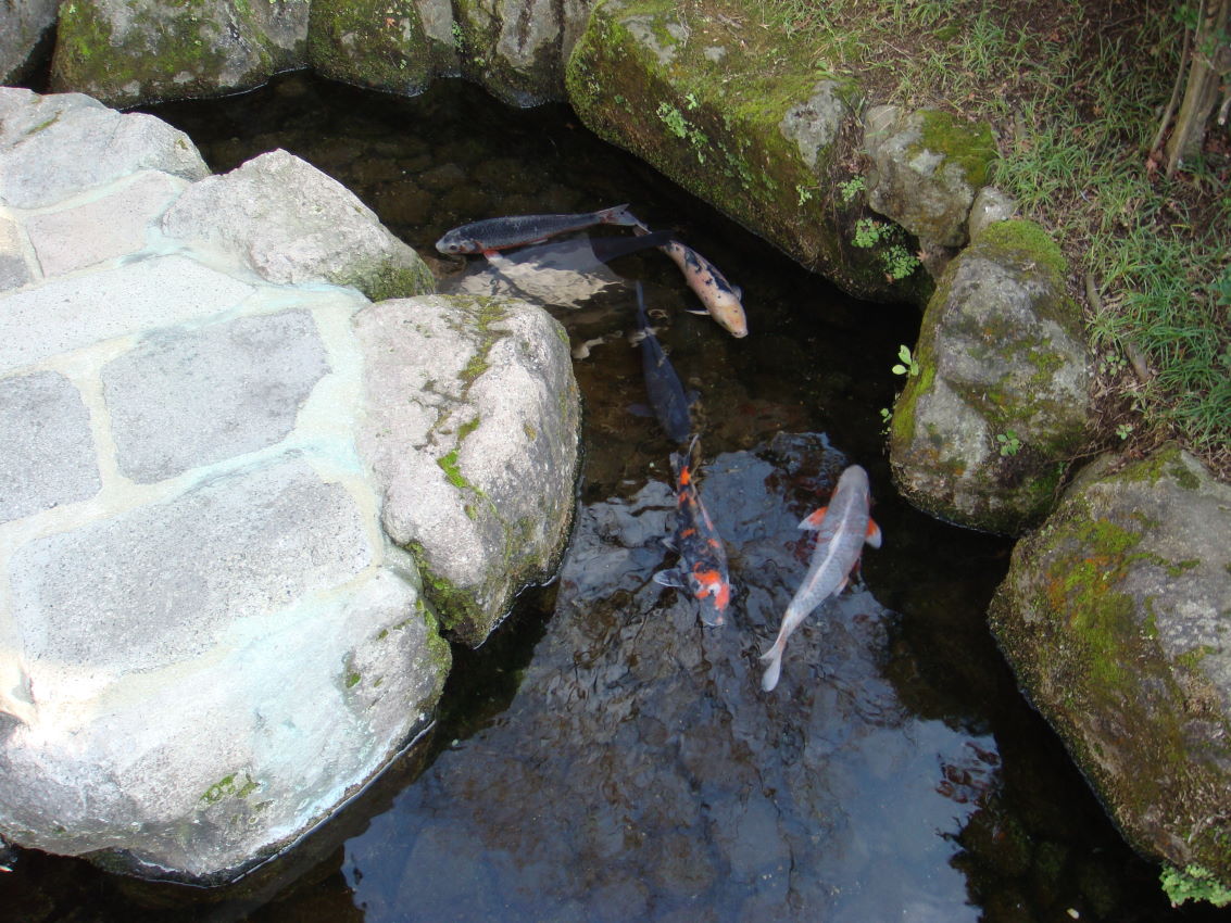
Koi Fish Town
Zoo and aquarium · 11.5 km
鮮やかな鯉が清らかな湧き水の水路で優雅に泳ぎ、島原市に美しい環境を作り出しています。伝統的な町並みが並ぶ魅力的な水路は、訪れる人々がこれらの魚の美しさを楽しむための穏やかな場所を提供します。



33 more on the map.
Museums and landmarks105


Harayama Dolmen Cluster
Monument and historic site · 10.9 km
Archaeological site in Japan


93 more on the map.
Parks, trails and playgrounds77




65 more on the map.
Restaurants and cafes45




33 more on the map.
History
The area of Unzen was part of ancient Hizen Province. During the Edo Period, the area was mostly under the control of Shimabara Domain. After the Meiji restoration, the villages of Tabira, Doguro, Jindai, Furube, Ifuku, Saigo, Moriyama, Yamada Aino, Chijiwa, Obama, Kuchiyama and Minamikushiyama were established in Minamitakaki District, Nagasaki with the creation of the modern municipalities system on April 1, 1889.
April 1, 1954 Moriyama and Yamada merged to form Agatsuma Village
February 1, 1955 Obama and Kitakushiyama villages merged to form Obama Town
September 1, 1956 Tabira and Doguro villages merged to form Kunimi Town
September 25, 1956 Taisho and Saigo village merged to form Mizuho Village
March 22, 1957 Jindai Village was raised to town status, becoming Kunimi Town
April 1, 1969 Mizuho Village → Mizuho Town, Minamikushiyama Village → Minamikushiyama Town
The city of Unzen was established on October 11, 2005, from the merger of the towns of Aino, Azuma, Chijiwa, Kunimi, Minamikushiyama, Mizuho and Obama (all from Minamitakaki District).
From the History section of Unzen, Nagasaki on Wikipedia, under CC BY-SA 4.0.
Where to stay44
Churches and places of worship59
Shopping20
Gas and EV charging19
Schools, colleges and libraries55
Healthcare18
Map of Unzen
250 places. The map loads OpenStreetMap tiles when you open it.
Getting there and nearby towns
Amakusa Airport (AXJ) is the nearest airport with scheduled flights listed in OpenStreetMap, 33 km away.
- Shimabara 11 km east, about 11 min by car
- Isahaya 21 km west, about 21 min by car
- Nagasu 26 km northeast, about 26 min by car
- Arao 30 km northeast, about 30 min by car
- Ōmura 32 km northwest, about 32 min by car
- Obita 34 km west, about 34 min by car
- Ōmuta 35 km northeast, about 35 min by car
- Amakusa 35 km south, about 35 min by car
- Hondomachi-hondo 35 km south, about 35 min by car
- Kumamoto 42 km east, about 42 min by car
Drive times are estimates from straight-line distance, not routes.
Local news
Headlines from INDB.
Reviews, tips and questions
Loading what members have shared...
Sources and licences
- GeoNames (CC BY 4.0): population, coordinates, regions and time zone
- OpenStreetMap contributors (ODbL 1.0): places, airports, map data
- Wikidata (CC0 1.0): elevation, founding date, time zone, website, landmarks and historic places
- Wikimedia Commons (see each image): photos
- Wikipedia (CC BY-SA 4.0): overview and history text
Photo credits
- Unzen Onsen Nagasaki pref banner, file:140322 Unzen Onsen Nagasaki pref Japan01s3.jpg : 663highland derivative work : Barbe-sauvage, CC BY-SA 3.0
- 140321 Azumaen Unzen Nagasaki pref Japan01o, 663highland, CC BY 2.5
- 140321 Azumaen Unzen Nagasaki pref Japan09as, 663highland, CC BY 2.5
- 140322 Azumaen Unzen Nagasaki pref Japan05s5, 663highland, CC BY 2.5
- 140322 Lake Oshidori Unzen Nagasaki pref Japan02o, 663highland, CC BY 2.5
- 140321 Azumaen Unzen Nagasaki pref Japan04s, 663highland, CC BY 2.5
- 140321 Azumaen Unzen Nagasaki pref Japan12s, 663highland, CC BY 2.5
- 140321 Azumaen Unzen Nagasaki pref Japan10ss, 663highland, CC BY 2.5
- 140322 Azumaen Unzen Nagasaki pref Japan02s3, 663highland, CC BY 2.5
- 140321 Azumaen Unzen Nagasaki pref Japan06s, 663highland, CC BY 2.5
- 140321 Azumaen Unzen Nagasaki pref Japan07s, 663highland, CC BY 2.5
- 140322 Azumaen Unzen Nagasaki pref Japan04n, 663highland, CC BY 2.5
- 140322 Azumaen Unzen Nagasaki pref Japan06s, 663highland, CC BY 2.5
- 140321 Azumaen Unzen Nagasaki pref Japan11s, 663highland, CC BY 2.5
- 140321 Azumaen Unzen Nagasaki pref Japan00s3, 663highland, CC BY 2.5
- 140322 Lake Oshidori Unzen Nagasaki pref Japan03o, 663highland, CC BY 2.5
- 140321 Lake Oshidori Unzen Nagasaki pref Japan02o, 663highland, CC BY 2.5
- 140321 Azumaen Unzen Nagasaki pref Japan03s, 663highland, CC BY 2.5
- 140322 Azumaen Unzen Nagasaki pref Japan01s3, 663highland, CC BY 2.5
- 140321 Azumaen Unzen Nagasaki pref Japan02s, 663highland, CC BY 2.5
- 140321 Azumaen Unzen Nagasaki pref Japan08ss, 663highland, CC BY 2.5
- 140322 Azumaen Unzen Nagasaki pref Japan07s, 663highland, CC BY 2.5
- 140321 Lake Oshidori Unzen Nagasaki pref Japan03o, 663highland, CC BY 2.5
- 140321 Lake Oshidori Unzen Nagasaki pref Japan01o, 663highland, CC BY 2.5
- 140321 Azumaen Unzen Nagasaki pref Japan05s, 663highland, CC BY 2.5
- 140321 Azumaen Unzen Nagasaki pref Japan09bs, 663highland, CC BY 2.5
- 140322 Azumaen Unzen Nagasaki pref Japan03s3, 663highland, CC BY 2.5
- Nagasaki Unzen, Jeong Ik Cho, CC BY 3.0
- 雲仙溫泉神社 Onsen Shrine Unzen - panoramio, lienyuan lee, CC BY 3.0
- Unzen Onsen Shrine 雲仙温泉神社 - panoramio (1), lienyuan lee, CC BY 3.0
- Unzen Onsen Shrine 雲仙温泉神社 - panoramio, lienyuan lee, CC BY 3.0
- Unzen Hot Spring 雲仙温泉 - panoramio, lienyuan lee, CC BY 3.0
- 140322 Unzen Onsen Unzen Nagasaki pref Japan13s3, 663highland, CC BY 2.5
- 140322 Unzen Onsen Unzen Nagasaki pref Japan14s3, 663highland, CC BY 2.5
- 140322 Unzen Onsen Unzen Nagasaki pref Japan08s3, 663highland, CC BY 2.5
- 140322 Unzen Onsen Unzen Nagasaki pref Japan09s3, 663highland, CC BY 2.5
- 140322 Unzen Onsen Unzen Nagasaki pref Japan15s3, 663highland, CC BY 2.5
- 140322 Unzen Onsen Unzen Nagasaki pref Japan05s3, 663highland, CC BY 2.5
- 140322 Unzen Onsen Unzen Nagasaki pref Japan19n, 663highland, CC BY 2.5
- 140322 Unzen Onsen Unzen Nagasaki pref Japan16n, 663highland, CC BY 2.5
- 140322 Unzen Onsen Nagasaki pref Japan01s3, 663highland, CC BY 2.5
- 140321 Shimabara Castle Shimabara Nagasaki pref Japan01bs5, 663highland, CC BY 2.5
- Unzen onsen jinja, Opqr, CC BY-SA 3.0
- Manmyo-ji Unzen 2026-07 ac (1), Asturio Cantabrio, CC BY-SA 4.0
- Nagasaki Prefecture Shimabara Hospital, user:Atsasebo, CC BY-SA 3.0
- Shimabara Koya Elementary School, hyolee2, CC BY-SA 4.0
- Shimabara 4th Elementary School, hyolee2, CC BY-SA 4.0
- Shimabara Athletic Stadium, 国土地理院, CC BY 4.0
- Shimabara 02, User: (WT-shared) Shirakawa-yobune at wts wikivoyage 09:24, 7 February 2008 (EST), CC BY-SA 1.0
- 140321 A view from Shimabara Castle Shimabara Nagasaki pref Japan01s3, 663highland, CC BY 2.5
- Unzen CIty Azuma Junior High School, Ackeyyama, CC0
- Unzen City Kitagushi Elementary School, Ackeyyama, CC0
- Minamishimabara Fukae Junior High School, hyolee2, CC BY-SA 4.0
- Minamishimabara Onokoba Elementary School, hyolee2, CC BY-SA 4.0
- Minamishimabara Kobayashi Elementary School, hyolee2, CC BY-SA 4.0
- Unzen City Tsuruta Elementary School, Ackeyyama, CC0
- Unzen City Mizuho Junior High School, Ackeyyama, CC0
- Unzen City Saigo Elementary School, Ackeyyama, CC0
- Unzen City Iwado Elementary School, Ackeyyama, CC0
- Moriyama-Otsuka Kofun, 運動会プロテインパワー, CC BY-SA 4.0


Page built November 5, 2026. Spotted a mistake? Tell us or suggest a place.