


Mission Canyon, California
Mission Canyon is a community of 2,357 people in Santa Barbara County, California.
Why visit Mission Canyon
Townapedia lists 35 museums and landmarks, 20 parks and trails, 32 places to eat, 7 places to stay and 9 attractions in and around town.
Highlights include Fielding Graduate University, Antioch University Santa Barbara, Santa Barbara Museum of Natural History and Allan Herschell 3-Abreast Carousel.
August is the warmest month, with average highs of 78°F; December lows average 46°F.
Weather in Mission Canyon
Forecast from the National Weather Service. Full forecast
About Mission Canyon
Mission Canyon is a census-designated place and an unincorporated suburb of Santa Barbara, California, in Santa Barbara County, United States. The population was 2,540 at the 2020 census, up from 2,381 at the 2010 census.
From the Wikipedia article Mission Canyon, California (this version), under CC BY-SA 4.0.
Things to do9

Fielding Graduate University
School · 1.5 mi
Private university in Santa Barbara, California, United States
Antioch University Santa Barbara
School · 2.6 mi
Private university in Santa Barbara, California, U.S.

Arlington Theatre
Cinema and theater · 2.9 mi
Movie theater in Santa Barbara, California, United States

Lobero Theatre
Cinema and theater · 2.6 mi
Theater and chamber music hall in Santa Barbara, California, United States


Museums and landmarks35

Santa Barbara Museum of Natural History
Museum · 1.1 mi
Natural history museum in Santa Barbara, California
2559 Puesta Del Sol, Santa Barbara
Mo-Su 10:00-17:00; Jan 01 off; Nov Th[4] off; Dec 25 off, Dec 24...

Allan Herschell 3-Abreast Carousel
Monument and historic site · National Register of Historic Places · 3.4 mi
Carousel by Allan Herschell Company

Andalucia Building
Monument and historic site · National Register of Historic Places · 3.1 mi
Commercial building in Santa Barbara, California

Casa de la Guerra
Monument and historic site · National Register of Historic Places · 2.7 mi
Place in California listed on National Register of Historic Places

Hill-Carrillo Adobe
Monument and historic site · National Register of Historic Places · 2.5 mi
Place in California listed on National Register of Historic Places

Hotel Savoy
Monument and historic site · National Register of Historic Places · 3.1 mi
Place in California listed on National Register of Historic Places

Janssens-Orella-Birk Building
Monument and historic site · National Register of Historic Places · 2.5 mi
Place in California listed on National Register of Historic Places

Presidio of Santa Barbara
Monument and historic site · National Register of Historic Places · 2.6 mi
18th-century Spanish fort in Santa Barbara, California, USA

Rafael Gonzalez House
Monument and historic site · National Register of Historic Places · 2.5 mi
Place in California listed on National Register of Historic Places
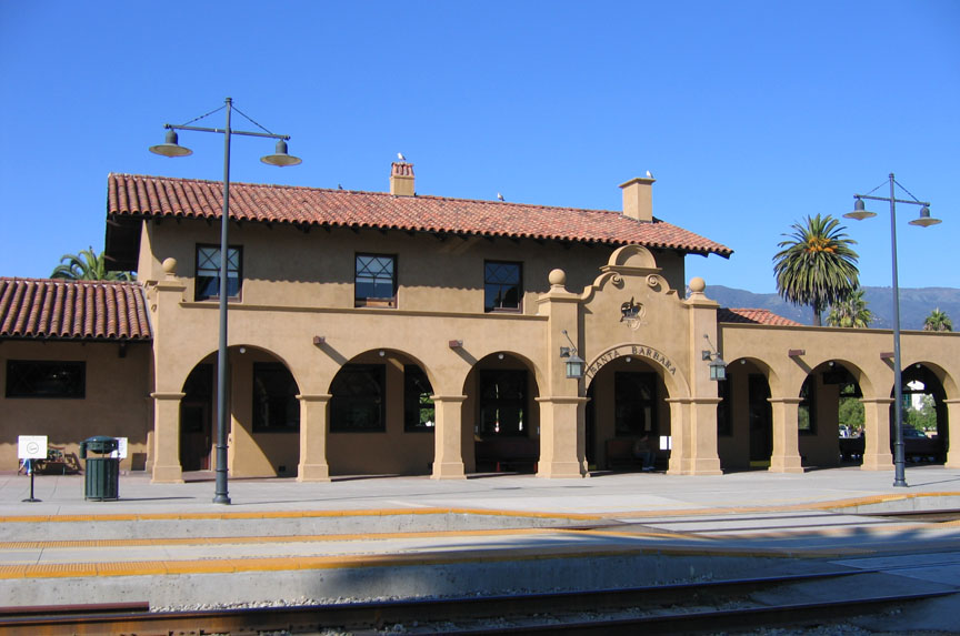
Santa Barbara
Monument and historic site · National Register of Historic Places · 3.3 mi
Train station in California listed on National Register of Historic Places

Santa Barbara County Courthouse
Monument and historic site · National Register of Historic Places · 2.4 mi
Place in California listed on National Register of Historic Places

Thomas Hope House
Monument and historic site · National Register of Historic Places · 3.4 mi
House in Santa Barbara, California
23 more on the map.
Parks, trails and playgrounds20

Mission Historical Park
Park · 1.3 mi
Public park in Santa Barbara, California, United States of America

Skofield Park
Park · 1.3 mi
Park in Santa Barbara, California, United States
1819 Las Canoas Road, Santa Barbara



Alice Keck Park Memorial Gardens
Park · 2.0 mi
Park in California, United States of America
De La Guerra Plaza
Park · 2.7 mi
Park in California, United States of America, United States of America
Elings Park
Park · 3.1 mi
Park in California, United States of America
Franceschi Park
Park · 1.7 mi
Park in Santa Barbara County, California, United States of America
Parma Park
Park · 2.2 mi
Park in Santa Barbara, California, United States of America, United States of America
San Marcos Foothills Preserve
Park · 2.4 mi
Nature reserve in Santa Barbara County, California
8 more on the map.
Restaurants and cafes32

Bree'osh
Cafe · Breakfast, Lunch, Coffee Shop, Pastry, Bread · 1.5 mi
2700 De La Vina Street, Santa Barbara
Mo-Su 06:30-14:00

El Sitio
Restaurant · Mexican · 1.4 mi
2830 De La Vina Street, Santa Barbara
Mo-Sa 08:00-20:30; Su off
Flavor Of India
Restaurant · Indian · 1.3 mi
3026 State Street, Santa Barbara
Mo-Sa 11:00-15:00,17:00-21:30; Su 12:00-15:00,16:30-21:00
Maíz Picante
Restaurant · Mexican · 1.5 mi
2714 De La Vina Street, Santa Barbara
Mo-Sa 11:00-22:00; Su 11:00-21:00
Petrini's Family Restaurant
Restaurant · Italian · 1.3 mi
14 West Calle Laureles, Santa Barbara
11:30-14:30,16:30-20:30
Presto Pasta
Restaurant · Italian · 1.4 mi
2830 De La Vina Street, Santa Barbara
Mo-Th,Su 10:30-21:00; Fr-Sa 10:30-22:00
Renaud's Patisserie and Bistro
Cafe · Pastry, Coffee Shop · 1.6 mi
3315 State Street, Santa Barbara
Mo-Sa 07:00-16:00; Su 07:00-15:00
Santa Barbara Chicken Ranch
Restaurant · Barbecue · 1.5 mi
2618 De La Vina Street, Santa Barbara
10:30-22:00
Starbucks
Cafe · Coffee Shop · 1.3 mi
3052 De La Vina Street, Santa Barbara
Mo-Fr 04:30-21:00; Sa-Su 05:00-21:00
20 more on the map.
Where to stay7
Autocamp Santa Barbara
Motel and hotel · 1.5 mi
2717 De La Vina St, Santa Barbara
Churches and places of worship11
Mission Santa Barbara
Church · Roman Catholic · National Register of Historic Places · 1.2 mi
2201 Laguna Street, Santa Barbara
Shopping6
Gas and EV charging3
Schools, colleges and libraries45
Healthcare4
Santa Barbara Vascular Specialists
Clinic and pharmacy · 1.5 mi
2621 De La Vina Street, Santa Barbara
Map of Mission Canyon
172 places. The map loads OpenStreetMap tiles when you open it.
Climate by month
Monthly table
| Month | High | Low | Rain | Snow |
|---|---|---|---|---|
| Jan | 67°F | 46°F | 4.4 in | 0.0 in |
| Feb | 67°F | 47°F | 4.4 in | 0.0 in |
| Mar | 68°F | 49°F | 3.2 in | 0.0 in |
| Apr | 71°F | 51°F | 1.0 in | 0.0 in |
| May | 72°F | 54°F | 0.4 in | 0.0 in |
| Jun | 73°F | 57°F | 0.1 in | 0.0 in |
| Jul | 76°F | 60°F | 0.0 in | 0.0 in |
| Aug | 78°F | 60°F | 0.0 in | 0.0 in |
| Sep | 78°F | 60°F | 0.1 in | 0.0 in |
| Oct | 76°F | 56°F | 0.8 in | 0.0 in |
| Nov | 71°F | 50°F | 1.4 in | 0.0 in |
| Dec | 66°F | 46°F | 3.1 in | 0.0 in |
U.S. Climate Normals 1991-2020 for Santa Barbara Hcn (3 mi away), NOAA NCEI.
People and cost of living
American Community Survey 5-year estimates, 2020-2024, U.S. Census Bureau. Estimates have margins of error, larger for small towns.
Disaster history
Santa Barbara County has had 29 federal disaster declarations since 2000, most often for fires.
- 2024-04-13: Severe Winter Storms, Tornadoes, Flooding, Landslides, And Mudslides (Severe Storm)
- 2023-04-03: Severe Winter Storms, Straight-Line Winds, Flooding, Landslides, And Mudslides (Severe Storm)
- 2023-03-10: Severe Winter Storms, Flooding, Landslides, And Mudslides (Flood)
- 2023-01-14: Severe Winter Storms, Flooding, Landslides, And Mudslides (Flood)
- 2023-01-09: Severe Winter Storms, Flooding, And Mudslides (Flood)
- 2021-10-13: Alisal Fire (Fire)
OpenFEMA disaster declarations summaries.
Getting there and nearby towns
Santa Barbara Municipal Airport (SBA) is the nearest airport with scheduled flights listed in OpenStreetMap, 7 miles away.
- Santa Barbara 4 mi south, about 6 min by car
- Eastern Goleta Valley 4 mi west, about 6 min by car
- Goleta 8 mi west, about 13 min by car
- University of California-Santa Barbara 8 mi west, about 13 min by car
- Isla Vista 9 mi west, about 14 min by car
- Carpinteria 13 mi east, about 21 min by car
- Meiners Oaks 25 mi east, about 41 min by car
- Los Olivos 27 mi northwest, about 43 min by car
- San Buenaventura (Ventura) 29 mi southeast, about 47 min by car
- Oxnard 34 mi southeast, about 55 min by car
Drive times are estimates from straight-line distance, not routes.
Local news
Headlines from INDB, the NEMICO news database.
Reviews, tips and questions
Loading what members have shared...
Sources and licences
- NCES EDGE (Public domain): public schools
- NOAA NCEI U.S. Climate Normals 1991-2020 (Public domain): climate by month
- OpenFEMA (Public domain): disaster declarations
- OpenStreetMap contributors (ODbL 1.0): places, airports, map data
- U.S. Census Bureau (Public domain): population, income, housing, education, commute
- Wikidata (CC0 1.0): elevation, founding date, time zone, website, landmarks and historic places
- Wikimedia Commons (see each image): photos
- Wikipedia (CC BY-SA 4.0): overview and history text
Photo credits
- SBCA SantaYnez NB 20170912, Niranjan Arminius, CC BY-SA 4.0
- Mission Santa Barbara01, Bernard Gagnon, CC BY-SA 3.0
- Santa Barbara Museum of Natural History - exterior, Jllm06, CC BY-SA 3.0
- Santa Barbara County Courthouse, Konrad Summers from Santa Clarita (Valencia) , California, USA, CC BY-SA 2.0
- Hill-Carrillo Adobe, Ymblanter, CC BY-SA 3.0
- Thomas Hope House, DocFreeman24, CC BY-SA 4.0
- Faith Mission Santa Barbara, Ymblanter, CC BY-SA 3.0
- Andalucia Building Santa Barbara 1, Ymblanter, CC BY-SA 3.0
- USA-Santa Barbara-Post Office, Eugene Zelenko (thanks to my friends Nickolov family for generous help and company), CC BY-SA 4.0
- Rafael Gonzalez House2, Ymblanter, CC BY-SA 3.0
- Presidio Chapel, Ymblanter, CC BY-SA 3.0
- Janssens-Orella-Birk Building, Ymblanter, CC BY-SA 3.0
- Virginia Hotel Santa Barbara, Ymblanter, CC BY-SA 3.0
- Allan Herschell 3-Abreast Carousel, Santa Barbara, California, Nick, CC BY 2.0
- Santa Barbara Station1, Marriedtofilm at English Wikipedia, CC BY-SA 3.0
- Casa de la Guerra right side, Ymblanter, CC BY-SA 3.0
- SantaBarbaraCA SkofieldPark 20170911, Niranjan Arminius, CC BY-SA 4.0
- SB MissionParkEast 20140909, Niranjan Arminius, CC BY-SA 4.0
- Santa Barbara Museum of Art exterior, Jllm06, CC BY-SA 3.0
- Arlington-front, DillyLynn, CC BY-SA 3.0
- AliceKeckParkMG, Summerrrz, CC BY-SA 4.0
- Santa Barbara Botanic Garden kz04, Krzysztof Ziarnek, Kenraiz, CC BY-SA 4.0
- Search Results Web Result with Site Links The Santa Barbara Botanic basket, Britta Gustafson from San Francisco, CA, CC BY-SA 2.0
- Santa Barbara Botanic Garden kz02, Krzysztof Ziarnek, Kenraiz, CC BY-SA 4.0
- Santa Barbara Botanic Garden kz03, Krzysztof Ziarnek, Kenraiz, CC BY-SA 4.0
- Santa Barbara Botanic Garden kz01, Krzysztof Ziarnek, Kenraiz, CC BY-SA 4.0
- Geology and Plants - Flickr - brewbooks, brewbooks from near Seattle, USA, CC BY-SA 2.0
- Eschscholzia californica kz12, Krzysztof Ziarnek, Kenraiz, CC BY-SA 4.0
- Flickr - brewbooks - Santa Cruz Island bush mallow (1), brewbooks from near Seattle, USA, CC BY-SA 2.0
- Asarum caudatum - Flickr - brewbooks, brewbooks from near Seattle, USA, CC BY-SA 2.0
- Flickr - brewbooks - Eriogonum grande var. rubescens (1), brewbooks from near Seattle, USA, CC BY-SA 2.0
- Sequoia sempervirens needles (underside) - Flickr - brewbooks, brewbooks from near Seattle, USA, CC BY-SA 2.0
- Flickr - brewbooks - Eriogonum grande var. rubescens leaf, brewbooks from near Seattle, USA, CC BY-SA 2.0
- Flickr - brewbooks - Eriogonum grande var. rubescens (2), brewbooks from near Seattle, USA, CC BY-SA 2.0
- Dryopteris arguta - Flickr - brewbooks, brewbooks from near Seattle, USA, CC BY-SA 2.0
- Sequoia sempervirens needles - Flickr - brewbooks, brewbooks from near Seattle, USA, CC BY-SA 2.0
- Arctostaphylos edmundsii - Flickr - brewbooks, brewbooks from near Seattle, USA, CC BY-SA 2.0
- Flickr - brewbooks - Eriogonum grande var. rubescens, brewbooks from near Seattle, USA, CC BY-SA 2.0
- Sequoia sempervirens bark - Flickr - brewbooks, brewbooks from near Seattle, USA, CC BY-SA 2.0
- Sequoia sempervirens needles - Flickr - brewbooks (2), brewbooks from near Seattle, USA, CC BY-SA 2.0


Page built October 30, 2026. Spotted a mistake? Tell us or suggest a place.