

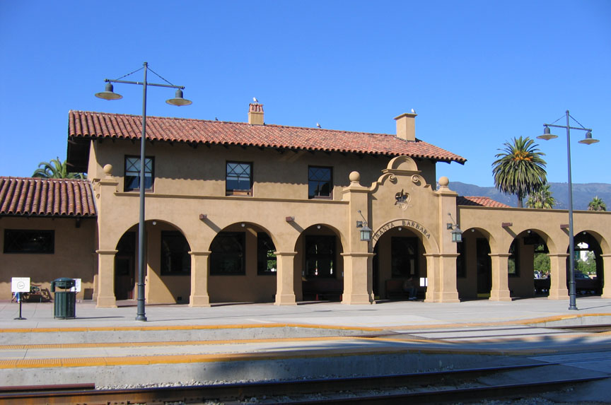


Santa Barbara, California
Santa Barbara is a city of 87,779 people in Santa Barbara County, California, founded in 1847.
Why visit Santa Barbara
Townapedia lists 70 museums and landmarks, 53 parks and trails, 286 places to eat, 47 places to stay and 24 attractions in and around town.
Highlights include Santa Barbara Museum of Natural History Sea Center, Lobero Theatre, Casa de la Guerra and Santa Barbara Historical Museum.
August is the warmest month, with average highs of 78°F; December lows average 46°F.
Weather in Santa Barbara
Forecast from the National Weather Service. Full forecast
About Santa Barbara
Santa Barbara (Spanish: Santa Bárbara, meaning 'Saint Barbara') is a coastal city in Santa Barbara County, California, of which it is also the county seat. Situated on a south-facing section of coastline, the longest such section on the West Coast of the United States excepting Alaska, the city lies between the steeply rising Santa Ynez Mountains and the Pacific Ocean. Santa Barbara's climate is often described as Mediterranean, and the city has been dubbed "The American Riviera". As of the 2020 census, Santa Barbara had a population of 88,665.
From the Wikipedia article Santa Barbara, California (this version), under CC BY-SA 4.0.
Things to do24

Santa Barbara Museum of Natural History Sea Center
Zoo and aquarium · 1.7 mi
211 Stearns Wharf, Santa Barbara
10:00-17:00; PH off

Lobero Theatre
Cinema and theater · 1.5 mi
Theater and chamber music hall in Santa Barbara, California, United States
33 East Canon Perdido Street, Santa Barbara

Antioch University Santa Barbara
School · 1.7 mi
Private university in Santa Barbara, California, U.S.
602 Anacapa Street, Santa Barbara

Arroyo Burro Beach
Beach · 1.7 mi
Public beach located in Santa Barbara, California, United States
Leadbetter Beach
Beach · 0.8 mi
Beach in Santa Barbara, California, U.S
Metropolitan Paseo Nuevo 4 Cinemas
Cinema and theater · 1.3 mi
8 West de la Guerra Street, Santa Barbara

Santa Barbara Light
Lighthouse · 0.8 mi
Lighthouse in California, United States
Arlington Theatre
Cinema and theater · 1.4 mi
Movie theater in Santa Barbara, California, United States
12 more on the map.
Museums and landmarks70

Casa de la Guerra
Museum · National Register of Historic Places · 1.4 mi
Place in California listed on National Register of Historic Places
15 East De la Guerra Street, Santa Barbara
Mo-We off; Th-Su 12:00-16:00

Santa Barbara Historical Museum
Museum · 1.6 mi
Non-profit organization in the USA
136 East De la Guerra Street, Santa Barbara
Mo-Tu off; We,Fr-Su 12:00-17:00; Th 12:00-19:00

Santa Barbara Museum of Art
Museum · 1.5 mi
Museum in Santa Barbara, California
1130 State Street, Santa Barbara
Mo off; Tu-Su 11:00-17:00; Th[1] 11:00-20:00

MOXI, The Wolf Museum of Exploration + Innovation
Museum · 1.4 mi
125 State Street, Santa Barbara
10:00-17:00
Museum Of Contemporary Art Santa Barbara
Museum · 1.3 mi
653 Paseo Nuevo, Santa Barbara
Mo off; Tu-Su 11:00-18:00

Andalucia Building
Monument and historic site · National Register of Historic Places · 1.4 mi
Commercial building in Santa Barbara, California

Trussell-Winchester Adobe
Monument and historic site · 1.0 mi
414 West Montecito Street, Santa Barbara
Acacia Lodge
Monument and historic site · National Register of Historic Places · 5.0 mi
Single-family detached home in Santa Barbara County, California
Allan Herschell 3-Abreast Carousel
Monument and historic site · National Register of Historic Places · 1.8 mi
Carousel by Allan Herschell Company
Casa del Herrero
Monument and historic site · National Register of Historic Places · 4.9 mi
Single-family detached home in Santa Barbara County, California
58 more on the map.
Parks, trails and playgrounds53


La Playa Stadium
Sports field and stadium · 1.0 mi
Park in Santa Barbara County, California, United States of America
Mo-Fr 06:00-22:00; Sa-Su 06:45-22:00

Alice Keck Park Memorial Gardens
Park · 1.8 mi
Park in California, United States of America
1500 Santa Barbara Street, Santa Barbara
Elings Park
Park · 1.4 mi
Park in California, United States of America
1298 Las Positas Road, Santa Barbara
sunrise-sunset
De La Guerra Plaza
Park · 1.4 mi
Park in California, United States of America, United States of America
Douglas Family Preserve
Park · 1.2 mi
Public park in Santa Barbara, California, United States
Arroyo Burro Beach County Park
Park · 1.6 mi
This oceanfront beach with seasonal lifeguards & a grassy area for picnicking allows off-leash dogs.
2981 Cliff Drive, Santa Barbara
Franceschi Park
Park · 2.7 mi
Park in Santa Barbara County, California, United States of America
Mission Historical Park
Park · 2.4 mi
Public park in Santa Barbara, California, United States of America
Parma Park
Park · 3.8 mi
Park in Santa Barbara, California, United States of America, United States of America
San Marcos Foothills Preserve
Park · 4.8 mi
Nature reserve in Santa Barbara County, California
41 more on the map.
Restaurants and cafes286

Mizza
Restaurant · Italian · 1.5 mi
"Artisan pizza & Italian cuisine"
1112 State Street, Santa Barbara
Mo-We,Su 11:00-21:00; Th-Sa 11:00-22:00

Pali Wine Co
Brewery and winery · 1.5 mi
205 Anacapa Street, Santa Barbara
Mo-Th 14:00-19:00; Fr 14:00-21:00; Sa 12:00-21:00; Su 12:00-19:00

Starbucks
Cafe · Coffee Shop · 1.2 mi
208 West Carrillo Street, Santa Barbara
Mo-Sa 04:30-22:30, Su 05:00-22:30
805 Boba
Cafe · Bubble Tea · 1.3 mi
651 Paseo Nuevo, Santa Barbara
Mo-Fr,Su 11:00-19:00; Sa 11:00-20:00
Aegean
Restaurant · Mediterranean · 1.4 mi
731 De la Guerra Place, Santa Barbara
Mo-We off; Th-Fr 17:00-21:00; Sa 16:00-21:00; Su 16:00-20:00
Ah Juice Organics
Cafe · Juice, Breakfast, Brunch · 1.8 mi
432 East Haley Street, Santa Barbara
Mo-Fr 07:30-16:30; Sa 09:00-14:00; Su off
Alcazar Tapas Bar
Restaurant · Spanish · 0.4 mi
1812 Cliff Drive, Santa Barbara
Mo-Sa 16:30-21:00; Su off
Alessia Patisserie & Cafe
Cafe · Breakfast, Brunch · 1.6 mi
134 East Canon Perdido Street, Santa Barbara
Mo off; Tu-Fr 07:00-16:00; Sa-Su 08:00-16:00
Anchor Rose
Restaurant · Seafood · 1.1 mi
113 Harbor Way, Santa Barbara
Mo-Fr 11:30-21:00; Sa-Su 11:00-21:00
Andersen's Danish Bakery and Restaurant
Restaurant · European · 1.5 mi
1106 State Street, Santa Barbara
Mo-Th 08:30-18:00; Fr-Su 08:30-20:00
274 more on the map.
History
Evidence of human habitation of the area begins at least 13,000 years ago. Evidence for a Paleoindian presence includes a fluted Clovis-like point found in the 1980s along the western Santa Barbara County coast, as well as the remains of Arlington Springs Man, found on Santa Rosa Island in the 1960s. At least 25,000 Chumash natives lived in the region prior to Spanish contact. Five Chumash villages flourished in the area. The present-day area of Santa Barbara City College was the village of Mispu; the site of the Los Baños pool (along west beach) was the village of Syukhtun, chief Yanonalit's large village located between Bath and Chapala streets; Amolomol was at the mouth of Mission Creek; and Swetete, above the bird refuge.
From the History section of Santa Barbara, California on Wikipedia, under CC BY-SA 4.0.
Where to stay47
Courtyard by Marriott Santa Barbara Downtown
Motel and hotel · 1.6 mi
1601 State Street, Santa Barbara
Churches and places of worship27
First Church of Christ, Scientist
Church · Christ Scientist · 1.8 mi
120 East Valerio Street, Santa Barbara
Unitarian Society of Santa Barbara
Place of worship · 1.8 mi
1535 Santa Barbara Street, Santa Barbara
St. Vladimir Orthodox Church
Church · Orthodox · 1.1 mi
1328 Castillo Street, Santa Barbara
Shopping45
Gas and EV charging13
Fuel Depot & The Point Market
Gas station · 1.3 mi
101 West Carrillo Street, Santa Barbara
Schools, colleges and libraries54
Healthcare15
Santa Barbara Primary & Specialty Care
Clinic and pharmacy · 1.6 mi
111 East Victoria Street, Santa Barbara
Maternal-Fetal Medicine Specialists of Southern California
Clinic and pharmacy · 1.8 mi
427 West Pueblo Street, Santa Barbara
Pueblo Street Obstetrics & Gynecology
Hospital · 1.8 mi
515 West Pueblo Street, Santa Barbara
Ralphs Pharmacy
Clinic and pharmacy · 1.2 mi
100 West Carrillo Street, Santa Barbara
Map of Santa Barbara
250 places. The map loads OpenStreetMap tiles when you open it.
Climate by month
Monthly table
| Month | High | Low | Rain | Snow |
|---|---|---|---|---|
| Jan | 67°F | 46°F | 4.4 in | 0.0 in |
| Feb | 67°F | 47°F | 4.4 in | 0.0 in |
| Mar | 68°F | 49°F | 3.2 in | 0.0 in |
| Apr | 71°F | 51°F | 1.0 in | 0.0 in |
| May | 72°F | 54°F | 0.4 in | 0.0 in |
| Jun | 73°F | 57°F | 0.1 in | 0.0 in |
| Jul | 76°F | 60°F | 0.0 in | 0.0 in |
| Aug | 78°F | 60°F | 0.0 in | 0.0 in |
| Sep | 78°F | 60°F | 0.1 in | 0.0 in |
| Oct | 76°F | 56°F | 0.8 in | 0.0 in |
| Nov | 71°F | 50°F | 1.4 in | 0.0 in |
| Dec | 66°F | 46°F | 3.1 in | 0.0 in |
U.S. Climate Normals 1991-2020 for Santa Barbara Hcn (2 mi away), NOAA NCEI.
People and cost of living
American Community Survey 5-year estimates, 2020-2024, U.S. Census Bureau. Estimates have margins of error, larger for small towns.
Disaster history
Santa Barbara County has had 29 federal disaster declarations since 2000, most often for fires.
- 2024-04-13: Severe Winter Storms, Tornadoes, Flooding, Landslides, And Mudslides (Severe Storm)
- 2023-04-03: Severe Winter Storms, Straight-Line Winds, Flooding, Landslides, And Mudslides (Severe Storm)
- 2023-03-10: Severe Winter Storms, Flooding, Landslides, And Mudslides (Flood)
- 2023-01-14: Severe Winter Storms, Flooding, Landslides, And Mudslides (Flood)
- 2023-01-09: Severe Winter Storms, Flooding, And Mudslides (Flood)
- 2021-10-13: Alisal Fire (Fire)
OpenFEMA disaster declarations summaries.
Getting there and nearby towns
Santa Barbara Municipal Airport (SBA) is the nearest airport with scheduled flights listed in OpenStreetMap, 7 miles away.
- Mission Canyon 4 mi north, about 6 min by car
- Montecito 5 mi east, about 8 min by car
- Eastern Goleta Valley 5 mi northwest, about 8 min by car
- Summerland 7 mi east, about 12 min by car
- University of California-Santa Barbara 8 mi west, about 12 min by car
- Isla Vista 8 mi west, about 14 min by car
- Goleta 9 mi west, about 14 min by car
- Toro Canyon 9 mi east, about 14 min by car
- Carpinteria 12 mi east, about 19 min by car
- San Buenaventura (Ventura) 28 mi east, about 45 min by car
Drive times are estimates from straight-line distance, not routes.
Local news
Headlines from INDB, the NEMICO news database.
Reviews, tips and questions
Loading what members have shared...
Sources and licences
- NCES EDGE (Public domain): public schools
- NOAA NCEI U.S. Climate Normals 1991-2020 (Public domain): climate by month
- OpenFEMA (Public domain): disaster declarations
- OpenStreetMap contributors (ODbL 1.0): places, airports, map data
- U.S. Census Bureau (Public domain): population, income, housing, education, commute
- Wikidata (CC0 1.0): elevation, founding date, time zone, website, landmarks and historic places
- Wikimedia Commons (see each image): photos
- Wikipedia (CC BY-SA 4.0): overview and history text
Photo credits
- Casa de la Guerra right side, Ymblanter, CC BY-SA 3.0
- Santa Barbara Station1, Marriedtofilm at English Wikipedia, CC BY-SA 3.0
- Santa Barbara Museum of Art exterior, Jllm06, CC BY-SA 3.0
- Historical Adobe Santa Barbara, Ymblanter, CC BY-SA 3.0
- Santa Barbara County Courthouse, Konrad Summers from Santa Clarita (Valencia) , California, USA, CC BY-SA 2.0
- Trinity Episcopal church, Santa Barbara, California (1), Chris06, CC BY-SA 4.0
- Andalucia Building Santa Barbara 1, Ymblanter, CC BY-SA 3.0
- La Playa Stadium, Santa Barbara, California, US, Clyde Charles Brown, CC BY-SA 4.0
Page built October 30, 2026. Spotted a mistake? Tell us or suggest a place.