


Montecito, California
Montecito is a community of 9,031 people in Santa Barbara County, California.
Why visit Montecito
Townapedia lists 35 museums and landmarks, 43 parks and trails, 52 places to eat, 11 places to stay and 9 attractions in and around town.
Highlights include Santa Barbara Zoological Gardens, Antioch University Santa Barbara, Casa del Herrero and Acacia Lodge.
August is the warmest month, with average highs of 78°F; December lows average 46°F.
Weather in Montecito
Forecast from the National Weather Service. Full forecast
About Montecito
Montecito (archaic use of Spanish for woodland or countryside) is an unincorporated town in Santa Barbara County, California, United States. Located in Southern California, Montecito sits between the Santa Ynez Mountains and the Pacific Ocean. Montecito is best known for its concentration of prominent and wealthy residents. In 2024, the median home price was $7.5 million.
From the Wikipedia article Montecito, California (this version), under CC BY-SA 4.0.
Things to do9


Antioch University Santa Barbara
School · 3.6 mi
Private university in Santa Barbara, California, U.S.

Arlington Theatre
Cinema and theater · 3.6 mi
Movie theater in Santa Barbara, California, United States

Leadbetter Beach
Beach · 4.0 mi
Beach in Santa Barbara, California, U.S
Lobero Theatre
Cinema and theater · 3.8 mi
Theater and chamber music hall in Santa Barbara, California, United States


Museums and landmarks35

Casa del Herrero
Museum · National Register of Historic Places · 1.2 mi
Single-family detached home in Santa Barbara County, California
1387 East Valley Road, Santa Barbara

Acacia Lodge
Monument and historic site · National Register of Historic Places · 0.4 mi
Single-family detached home in Santa Barbara County, California

Allan Herschell 3-Abreast Carousel
Monument and historic site · National Register of Historic Places · 3.0 mi
Carousel by Allan Herschell Company

Andalucia Building
Monument and historic site · National Register of Historic Places · 3.5 mi
Commercial building in Santa Barbara, California

Casa de la Guerra
Monument and historic site · National Register of Historic Places · 3.8 mi
Place in California listed on National Register of Historic Places

Hill-Carrillo Adobe
Monument and historic site · National Register of Historic Places · 3.9 mi
Place in California listed on National Register of Historic Places

Hotel Savoy
Monument and historic site · National Register of Historic Places · 3.5 mi
Place in California listed on National Register of Historic Places

Janssens-Orella-Birk Building
Monument and historic site · National Register of Historic Places · 4.0 mi
Place in California listed on National Register of Historic Places

Presidio of Santa Barbara
Monument and historic site · National Register of Historic Places · 3.7 mi
18th-century Spanish fort in Santa Barbara, California, USA

Rafael Gonzalez House
Monument and historic site · National Register of Historic Places · 3.6 mi
Place in California listed on National Register of Historic Places
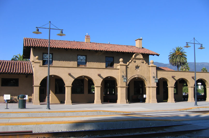
Santa Barbara
Monument and historic site · National Register of Historic Places · 3.4 mi
Train station in California listed on National Register of Historic Places


Santa Barbara County Courthouse
Monument and historic site · National Register of Historic Places · 4.0 mi
Place in California listed on National Register of Historic Places
23 more on the map.
Parks, trails and playgrounds43

Alice Keck Park Memorial Gardens
Park · 4.2 mi
Park in California, United States of America
De La Guerra Plaza
Park · 3.8 mi
Park in California, United States of America, United States of America
Franceschi Park
Park · 3.8 mi
Park in Santa Barbara County, California, United States of America
La Playa Stadium
Park · 3.7 mi
Park in Santa Barbara County, California, United States of America
Mission Historical Park
Park · 4.7 mi
Public park in Santa Barbara, California, United States of America

Parma Park
Park · 3.5 mi
Park in Santa Barbara, California, United States of America, United States of America
Shoreline Park, Santa Barbara
Park · 4.5 mi
Public park in Santa Barbara County, California, United States of America
Skofield Park
Park · 4.4 mi
Park in Santa Barbara, California, United States
31 more on the map.
Restaurants and cafes52

Alma Fonda Fina
Restaurant · Mexican · 1.1 mi
1024 Coast Village Road, Santa Barbara
Mo-Su 08:00-21:00
Ca'Dario Ristorante
Restaurant · Italian · 0.7 mi
1187 Coast Village Road, Montecito
Mo-Th,Su 11:30-20:15; Fr-Sa 11:30-21:00

China Palace
Restaurant · Chinese · 1.0 mi
1070 Coast Village Road, Santa Barbara
11:30-15:00,16:00-21:00
Jeannine's Restaurant & Bakery
Restaurant · Breakfast · 0.5 mi
1253 Coast Village Road, Montecito
07:30-14:00
Lilac Montecito
Restaurant · French · 0.6 mi
1209 Coast Village Road, Montecito
Mo 08:00-15:00; Tu-Su 08:00-21:00
Los Arroyos
Restaurant · Mexican · 0.5 mi
1280 Coast Village Road, Montecito
Mo-Fr 11:00-21:00; Sa-Su 10:00-21:00
Ospi
Restaurant · Italian · 1.4 mi
1801 East Cabrillo Boulevard, Santa Barbara
Mo-Fr 08:00-21:00; Sa-Su 10:00-21:00
40 more on the map.
History
The site of present-day Montecito, along with the entire south coast of Santa Barbara County, was inhabited for over 10,000 years by the Chumash Indians. The Spanish arrived in the 18th century but left the region largely unsettled while they built the Presidio and Mission Santa Barbara farther west.
In the middle of the 19th century, the area was known as a haven for bandits and highway robbers, who hid in the oak groves and canyons, preying on traffic on the coastal route between the towns that developed around the missions. By the end of the 1860s, the bandit gangs were gone, and Italian settlers arrived. Finding an area reminiscent of Italy, they built farms and gardens similar to those they had left behind.
Around the end of the 19th century, wealthy tourists from the eastern and midwestern United States began to buy land in the area. It was near enough to Santa Barbara for essential services while still being secluded. Desirable weather and several nearby hot springs offered the promise of comfortable, healthy living, in addition to the availability of affordable land.
The Montecito Hot Springs Hotel was built near the largest of the springs, in a canyon north of the town center and directly south of Montecito Peak, in Hot Springs Canyon. The hotel burned down in 1920; it was replaced a few years later by the smaller Hot Springs Club.
From the History section of Montecito, California on Wikipedia, under CC BY-SA 4.0.
Where to stay11
Four Seasons Resort: The Biltmore Santa Barbara
Motel and hotel · 0.5 mi
1260 Channel Drive, Santa Barbara
Hilton Santa Barbara Beachfront Resort
Motel and hotel · 2.5 mi
633 East Cabrillo Boulevard, Santa Barbara
Hyatt Santa Barbara
Motel and hotel · 2.1 mi
1111;1039 East Cabrillo Boulevard;Orilla Del Mar Drive, Santa Barbara
Churches and places of worship11
Summerland Presbyterian Church
Church · Presbyterian · 2.1 mi
2400 Valencia Road, Summerland
Shopping13
Gas and EV charging4
Schools, colleges and libraries41
Eastside Branch Santa Barbara Public Library
Library · 2.7 mi
1102 East Montecito Street, Santa Barbara
Healthcare4
Map of Montecito
223 places. The map loads OpenStreetMap tiles when you open it.
Climate by month
Monthly table
| Month | High | Low | Rain | Snow |
|---|---|---|---|---|
| Jan | 67°F | 46°F | 4.4 in | 0.0 in |
| Feb | 67°F | 47°F | 4.4 in | 0.0 in |
| Mar | 68°F | 49°F | 3.2 in | 0.0 in |
| Apr | 71°F | 51°F | 1.0 in | 0.0 in |
| May | 72°F | 54°F | 0.4 in | 0.0 in |
| Jun | 73°F | 57°F | 0.1 in | 0.0 in |
| Jul | 76°F | 60°F | 0.0 in | 0.0 in |
| Aug | 78°F | 60°F | 0.0 in | 0.0 in |
| Sep | 78°F | 60°F | 0.1 in | 0.0 in |
| Oct | 76°F | 56°F | 0.8 in | 0.0 in |
| Nov | 71°F | 50°F | 1.4 in | 0.0 in |
| Dec | 66°F | 46°F | 3.1 in | 0.0 in |
U.S. Climate Normals 1991-2020 for Santa Barbara Hcn (3 mi away), NOAA NCEI.
People and cost of living
American Community Survey 5-year estimates, 2020-2024, U.S. Census Bureau. Estimates have margins of error, larger for small towns.
Disaster history
Santa Barbara County has had 29 federal disaster declarations since 2000, most often for fires.
- 2024-04-13: Severe Winter Storms, Tornadoes, Flooding, Landslides, And Mudslides (Severe Storm)
- 2023-04-03: Severe Winter Storms, Straight-Line Winds, Flooding, Landslides, And Mudslides (Severe Storm)
- 2023-03-10: Severe Winter Storms, Flooding, Landslides, And Mudslides (Flood)
- 2023-01-14: Severe Winter Storms, Flooding, Landslides, And Mudslides (Flood)
- 2023-01-09: Severe Winter Storms, Flooding, And Mudslides (Flood)
- 2021-10-13: Alisal Fire (Fire)
OpenFEMA disaster declarations summaries.
Getting there and nearby towns
Santa Barbara Municipal Airport (SBA) is the nearest airport with scheduled flights listed in OpenStreetMap, 12 miles away.
- Summerland 3 mi east, about 4 min by car
- Toro Canyon 4 mi east, about 6 min by car
- Santa Barbara 5 mi west, about 8 min by car
- Mission Canyon 5 mi northwest, about 9 min by car
- Carpinteria 7 mi east, about 12 min by car
- Eastern Goleta Valley 9 mi west, about 14 min by car
- University of California-Santa Barbara 12 mi west, about 20 min by car
- Goleta 13 mi west, about 21 min by car
- Isla Vista 13 mi west, about 21 min by car
- Mira Monte 20 mi east, about 32 min by car
Drive times are estimates from straight-line distance, not routes.
Local news
Headlines from INDB, the NEMICO news database.
Reviews, tips and questions
Loading what members have shared...
Sources and licences
- NCES EDGE (Public domain): public schools
- NOAA NCEI U.S. Climate Normals 1991-2020 (Public domain): climate by month
- OpenFEMA (Public domain): disaster declarations
- OpenStreetMap contributors (ODbL 1.0): places, airports, map data
- U.S. Census Bureau (Public domain): population, income, housing, education, commute
- Wikidata (CC0 1.0): elevation, founding date, time zone, website, landmarks and historic places
- Wikimedia Commons (see each image): photos
- Wikipedia (CC BY-SA 4.0): overview and history text
Photo credits
- View over Montecito, Grandhiking, CC BY-SA 3.0
- Casa del Herrero (Montecito, CA), Mike Boucher, CC BY 2.0
- Santa Barbara County Courthouse, Konrad Summers from Santa Clarita (Valencia) , California, USA, CC BY-SA 2.0
- Hill-Carrillo Adobe, Ymblanter, CC BY-SA 3.0
- Faith Mission Santa Barbara, Ymblanter, CC BY-SA 3.0
- Andalucia Building Santa Barbara 1, Ymblanter, CC BY-SA 3.0
- USA-Santa Barbara-Post Office, Eugene Zelenko (thanks to my friends Nickolov family for generous help and company), CC BY-SA 4.0
- Rafael Gonzalez House2, Ymblanter, CC BY-SA 3.0
- Santa Barbara County - Acacia Lodge - 20201010155419, Vivalande, CC BY-SA 4.0
- Presidio Chapel, Ymblanter, CC BY-SA 3.0
- Janssens-Orella-Birk Building, Ymblanter, CC BY-SA 3.0
- Virginia Hotel Santa Barbara, Ymblanter, CC BY-SA 3.0
- Allan Herschell 3-Abreast Carousel, Santa Barbara, California, Nick, CC BY 2.0
- Santa Barbara Station1, Marriedtofilm at English Wikipedia, CC BY-SA 3.0
- Casa de la Guerra right side, Ymblanter, CC BY-SA 3.0
- Driftwood (3278407009), Damian Gadal, CC BY 2.0
- We could walk forever (4350464324), Damian Gadal, CC BY 2.0
- Friendship (3854713048), Damian Gadal, CC BY 2.0
- Rosewood Miramar Beach Lifeguard, Brett Morrison, CC BY 2.0
- Rosewood Miramar Beach - 53762224674, Brett Morrison, CC BY 2.0
- Rosewood Miramar Swim Platform - Rick Caruso (53762225174), Brett Morrison, CC BY 2.0
- Rosewood Miramar Beach Lifeguards - 53762224804, Brett Morrison, CC BY 2.0
- Rosewood Miramar Beach Lifeguards - 53762306515, Brett Morrison, CC BY 2.0
- Empty Rosewood Miramar Swim Platform, Brett Morrison, CC BY 2.0
- Rosewood Miramar Swim Platform, Brett Morrison, CC BY 2.0
- Rosewood Miramar Swim Platform - Rick Caruso (53762092978), Brett Morrison, CC BY 2.0
- Tell me nothing's wrong (3367117743), Damian Gadal, CC BY 2.0
- Joe, Don & Simon, Rosewood(51967162681), lamblukas from San Francisco, United States, CC BY 2.0
- Sunset Sisters (4091999539), Damian Gadal, CC BY 2.0
- Rosewood Miramar Swim Platform 1, Brett Morrison, CC BY 2.0
- Rosewood Miramar Swim Platform 3, Brett Morrison, CC BY 2.0
- Rosewood Miramar Beach - 54526002131, Brett Morrison, CC BY 2.0
- Rosewood Miramar Swim Platform - 54526345035, Brett Morrison, CC BY 2.0
- Rosewood Miramar Beach - 54525119812, Brett Morrison, CC BY 2.0
- Rosewood Miramar Swim Platform - 54526239248, Brett Morrison, CC BY 2.0
- Rosewood Miramar Swim Platform 2, Brett Morrison, CC BY 2.0
- Rosewood Miramar Beach - 54526345310, Brett Morrison, CC BY 2.0
- Rosewood Miramar Swim Platform - 54526244393, Brett Morrison, CC BY 2.0
- Rosewood Miramar Beach - 54526339955, Brett Morrison, CC BY 2.0
- Twilight at Rosewood Miramar Beach, Damian Gadal, CC BY 2.0


Page built October 30, 2026. Spotted a mistake? Tell us or suggest a place.