
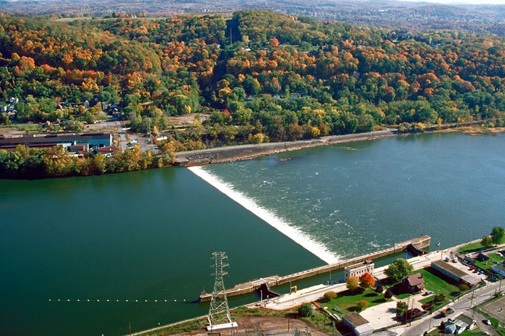

Natrona Heights, Pennsylvania
Natrona Heights is a community of 6,903 people in Pennsylvania.
Why visit Natrona Heights
Townapedia lists 10 museums and landmarks, 3 parks and trails, 10 places to eat and 1 attraction in and around town.
Highlights include George D. Stuart Bridge, Allegheny River Lock and Dam No. 4 and Burtner House.
July is the warmest month, with average highs of 83°F; January lows average 20°F.
Weather in Natrona Heights
Forecast from the National Weather Service. Full forecast
Things to do1


George D. Stuart Bridge
Bridge · 2.4 mi
Bridge over the Allegheny River in Pennsylvania
Museums and landmarks10
Allegheny River Lock and Dam No. 4
Monument and historic site · National Register of Historic Places · 0.8 mi
Gravity dam and lock in Harrison Township, Pennsylvania

Burtner House
Monument and historic site · National Register of Historic Places · 0.6 mi
Historic house in Pennsylvania, United States
Pennsalt Historic District
Monument and historic site · National Register of Historic Places · 0.7 mi
Historic district in Pennsylvania, United States
Esplanade
Monument and historic site · 0.8 mi
The esplanade consists of concrete-paved fill between the former river bank and the lock's land wall.
Lock No. 4
Monument and historic site · 0.8 mi
The lock, 56 by 360 feet, has a lift of 10.6 feet, from 734.8 to 745.4 feet. The sidewalls are steel-armored concrete, and mooring pins...
Parks, trails and playgrounds3


Restaurants and cafes10


Phillippi's
Restaurant · American, Pizza · 0.4 mi
2105 Freeport Road, Natrona Heights
Mo-Sa 08:00-02:00; Su 09:00-02:00
Maddio's Pizza and Subs
Restaurant · Pizza, Sandwich · 1.2 mi
1000 Broadview Boulevard, Brackenridge
Mo-We 11:00-21:00, Th-Sa 11:00-23:00; Su 12:00-21:00

Churches and places of worship10
Faith Lutheran Church
Church · Lutheran · 0.4 mi
1500 Broadview Boulevard, Natrona Heights
Shopping1
Gas and EV charging2
Schools, colleges and libraries23
Healthcare1
Map of Natrona Heights
61 places. The map loads OpenStreetMap tiles when you open it.
Climate by month
Monthly table
| Month | High | Low | Rain |
|---|---|---|---|
| Jan | 36°F | 20°F | 3.1 in |
| Feb | 40°F | 21°F | 2.8 in |
| Mar | 50°F | 27°F | 3.3 in |
| Apr | 62°F | 38°F | 3.6 in |
| May | 72°F | 50°F | 3.9 in |
| Jun | 80°F | 59°F | 4.3 in |
| Jul | 83°F | 63°F | 4.3 in |
| Aug | 82°F | 62°F | 3.5 in |
| Sep | 76°F | 55°F | 4.0 in |
| Oct | 64°F | 43°F | 3.1 in |
| Nov | 52°F | 33°F | 3.1 in |
| Dec | 41°F | 26°F | 3.3 in |
U.S. Climate Normals 1991-2020 for Natrona Lock 4 (1 mi away), NOAA NCEI.
People and cost of living
American Community Survey 5-year estimates, 2020-2024, U.S. Census Bureau. Estimates have margins of error, larger for small towns.
Getting there and nearby towns
Pittsburgh-Butler Regional Airport (BTP) is the nearest airport with scheduled flights listed in OpenStreetMap, 16 miles away.
- Brackenridge 1 mi southwest, about 2 min by car
- Lower Burrell 3 mi south, about 5 min by car
- New Kensington 4 mi south, about 6 min by car
- Arnold 4 mi southwest, about 6 min by car
- Freeport 5 mi northeast, about 8 min by car
- West Leechburg 6 mi east, about 9 min by car
- Russellton 6 mi west, about 10 min by car
- Leechburg 7 mi east, about 10 min by car
- Cheswick 7 mi southwest, about 11 min by car
- Plum 8 mi south, about 14 min by car
Drive times are estimates from straight-line distance, not routes.
Local news
Headlines from INDB, the NEMICO news database.
Reviews, tips and questions
Loading what members have shared...
Sources and licences
- NCES EDGE (Public domain): public schools
- NOAA NCEI U.S. Climate Normals 1991-2020 (Public domain): climate by month
- OpenStreetMap contributors (ODbL 1.0): places, airports, map data
- U.S. Census Bureau (Public domain): population, income, housing, education, commute
- Wikidata (CC0 1.0): landmarks and historic places
- Wikimedia Commons (see each image): photos
Photo credits
- Allegheny River Lock and Dam No.4, U.S. Army Corps of Engineers, Public domain
- Tarentumbridge, Mr. Vitale ( talk ), Public domain
Page built October 30, 2026. Spotted a mistake? Tell us or suggest a place.