


Why visit Badagry
Townapedia lists 13 museums and landmarks, 1 park or trail, 1 place to eat, 2 places to stay and 2 attractions in and around town.
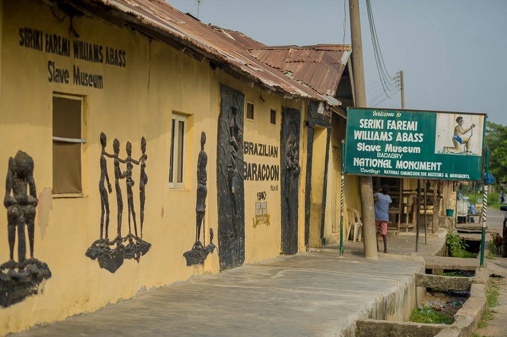
Highlights include Suntan Beach, Agiya Tree Monument, Seriki William Abass Slave Museum and Suntan Beach.
Weather in Badagry
Forecast from MET Norway (CC BY 4.0). Full forecast
About Badagry
Badagry, also spelled Badagri, (Gun: Gbagli) is a coastal city and Local Government Area (LGA) in the Badagry Division of Lagos State, Nigeria. It is quite close to the city of Lagos, and located on the north bank of Porto Novo Creek, an inland waterway that connects Lagos (Nigeria's largest city and economic capital) to the Beninese capital of Porto-Novo. The same route connects Lagos, Ilaro, and Porto-Novo, and shares a border with the Republic of Benin. As of the preliminary 2006 census results, the municipality had a population of 241,093.
From the Wikipedia article Badagry (this version), under CC BY-SA 4.0.
Travel tips from other travellers: Badagry on Wikivoyage (CC BY-SA 4.0).
Things to do2


Museums and landmarks13

Agiya Tree Monument
Monument and historic site
Place where Christianity was first preached in Nigeria


Mobee Royal Family Slave Relics Museum
Museum
Museum in Badagry, Nigeria




1 more on the map.
Parks, trails and playgrounds1
Restaurants and cafes1

History
There is a traditional Yoruba narrative that the first settlement within the area was an Awori group originally from Ile-Ife who lived at a nearby settlement. Robin Law, a scholar of West African history, notes an origin that sprouted out of a resettlement for displaced peoples of varied ethnic groups, mostly Ogu people, Ewe people and Oyo Yorubas. Another source links the people living at a settlement called Gberefu as the Ewe's of Oyo, an island along the Atlantic coast.
One of the recorded notable events in the history of Badagry was the acquisition of land by a European trader who was locally known as Yovo Huntɔkonu. Yovo or Yevu means a white person in Gbe languages. Many sources identify the European to be a Dutch trader called Hendrik Hertogh. Huntɔkonu meaning(laughing or smiling priest)arrived from the west, settling in the area after fleeing the wrath of an African chief. He reached the settlement called Apa under the Obaship of Alapa and he was given farmland to use for trading.
From the History section of Badagry on Wikipedia, under CC BY-SA 4.0.
Where to stay2
Churches and places of worship3
Schools, colleges and libraries14
Healthcare3
Adebayo Living Tower Hospital
Hospital · 11.5 km
8 Adebayo Ojajuni Street, Off Kemuye Bus-Stop,, Imeke-Badagry
Map of Badagry
39 places. The map loads OpenStreetMap tiles when you open it.
Getting there and nearby towns
Murtala Mohammed International Airport (LOS) is the nearest airport with scheduled flights listed in OpenStreetMap, 52 km away.
- Tube 17 km northwest, about 17 min by car
- Ado-Odo 21 km north, about 21 min by car
- Irewe 29 km east, about 29 min by car
- Alasia 32 km east, about 32 min by car
- Surulere 54 km east, about 54 min by car
- Agege 55 km northeast, about 55 min by car
- Ikeja 55 km east, about 55 min by car
- Lagos 57 km east, about 57 min by car
- Shomolu 56 km east, about 56 min by car
- Obalende 59 km east, about 59 min by car
Drive times are estimates from straight-line distance, not routes.
Local news
Headlines from INDB.
Reviews, tips and questions
Loading what members have shared...
Sources and licences
- GeoNames (CC BY 4.0): population, coordinates, regions and time zone
- OpenStreetMap contributors (ODbL 1.0): places, airports, map data
- Wikidata (CC0 1.0): elevation, founding date, time zone, website, landmarks and historic places
- Wikimedia Commons (see each image): photos
- Wikipedia (CC BY-SA 4.0): overview and history text
Photo credits
- BADAGRY ROUNDABOUT Lagos state Nigeria, Photogbeleyi, CC BY-SA 4.0
- The fisherman statue in Badagry, Layefa805, CC BY-SA 4.0
- The great fisherman statue in Badagry, Layefa805, CC BY-SA 4.0
- Image of Christmas in Badagry, Layefa805, CC BY-SA 4.0
- Zangbeto Display in Badagry Lagos, Nigeria 06, Olabinjo, CC BY-SA 4.0
- Zangbeto Display in Badagry Lagos, Nigeria 17, Olabinjo, CC BY-SA 4.0
- Zangbeto Display in Badagry Lagos, Nigeria 19, Olabinjo, CC BY-SA 4.0
- Zangbeto Display in Badagry Lagos, Nigeria 01, Olabinjo, CC BY-SA 4.0
- Zangbeto Display in Badagry Lagos, Nigeria 16, Olabinjo, CC BY-SA 4.0
- Zangbeto Display in Badagry Lagos, Nigeria 09, Olabinjo, CC BY-SA 4.0
- Zangbeto Display in Badagry Lagos, Nigeria 08, Olabinjo, CC BY-SA 4.0
- Zangbeto Display in Badagry Lagos, Nigeria 18, Olabinjo, CC BY-SA 4.0
- Zangbeto Display in Badagry Lagos, Nigeria 12, Olabinjo, CC BY-SA 4.0
- Zangbeto Display in Badagry Lagos, Nigeria 13, Olabinjo, CC BY-SA 4.0
- Zangbeto Display in Badagry Lagos, Nigeria 14, Olabinjo, CC BY-SA 4.0
- CHRIST WAS FIRST PREACHED HERE, BADAGRY. THE AGIA TREE, Samuel Tobbytex007, CC BY-SA 4.0
- Seriki Abass Slave Museum, T Cells, CC BY-SA 4.0
- Beautiful Suntan Beach, Badagry, Ajisafe Victor, CC BY-SA 4.0
- 230738130 Mobee Royal Family Museum, Solasly, CC BY-SA 4.0
- 231108321 Point of No Return, Badagry, Solasly, CC BY-SA 4.0
- Slave Market Vlekete, Fellyx, CC BY-SA 4.0
- After School Wikipedia Editing, Badagry, Lagos 15, Samatics, CC BY-SA 4.0
- Aerial view of Ajara Grammar School, Yemi festus, CC BY 4.0
- Front view of Vlekete slave market, Gabeto22, CC BY-SA 4.0
- Badagry Slave Museum, Badagry, Yemi festus, CC BY-SA 4.0
- Suntan beach resort Badagry 03, MediaMOF, CC BY-SA 4.0
- The canon gun, Layefa805, CC BY-SA 4.0
- The dungeon, Layefa805, CC BY-SA 4.0
- Image found in slave market museum, Layefa805, CC BY-SA 4.0
- Cenotaph of Seriki Abass, Samatics, CC BY-SA 4.0
- Building of slave market in Nigeria, Layefa805, CC BY-SA 4.0
- Image of selling slave, Layefa805, CC BY-SA 4.0
- Image of a shrine, Layefa805, CC BY-SA 4.0
- Street food vendor, Dophonkovi, CC BY-SA 4.0
- Seriki Faremi Williams Abass Slave Museum, Explora20, CC BY-SA 4.0
- Cannon guns, Samatics, CC BY-SA 4.0
- The first naira note, Layefa805, CC BY-SA 4.0
- Image of the first story building in Nigeria, Layefa805, CC BY-SA 4.0
- Frame found inside the first story building, Layefa805, CC BY-SA 4.0
- The first well dug in Nigeria, Layefa805, CC BY-SA 4.0


Page built November 3, 2026. Spotted a mistake? Tell us or suggest a place.