


North Adams, Massachusetts
North Adams is a city of 12,606 people in Berkshire County, Massachusetts, founded in 1745.
Why visit North Adams
Townapedia lists 62 museums and landmarks, 33 parks and trails, 39 places to eat, 9 places to stay and 21 attractions in and around town.
Highlights include Mohawk Theater, Bald Mountain, Hillside Cemetery and Church Street Historic District.
July is the warmest month, with average highs of 81°F; January lows average 14°F.
Weather in North Adams
Forecast from the National Weather Service. Full forecast
About North Adams
North Adams is a city in Berkshire County, Massachusetts, United States. It is part of the Pittsfield, Massachusetts Metropolitan Statistical Area. Its population was 12,961 as of the 2020 census. Best known as the home of the largest contemporary art museum in the United States, the Massachusetts Museum of Contemporary Art, North Adams has in recent years become a center for tourism, culture and recreation.
From the Wikipedia article North Adams, Massachusetts (this version), under CC BY-SA 4.0.
Things to do21



9 more on the map.
Museums and landmarks62

Hillside Cemetery
Monument and historic site · National Register of Historic Places · 1.7 mi
Cemetery in North Adams, Massachusetts
Church Street Historic District
Monument and historic site · National Register of Historic Places · 1.6 mi
Listed on the NRHP in Massachusetts
Massachusetts Museum of Contemporary Art
Museum · 1.8 mi
Museum in North Adams, Massachusetts
1040 MASS MoCA Way, North Adams

Adams
Monument and historic site · National Register of Historic Places · 3.7 mi
Former train station in Adams, Massachusetts
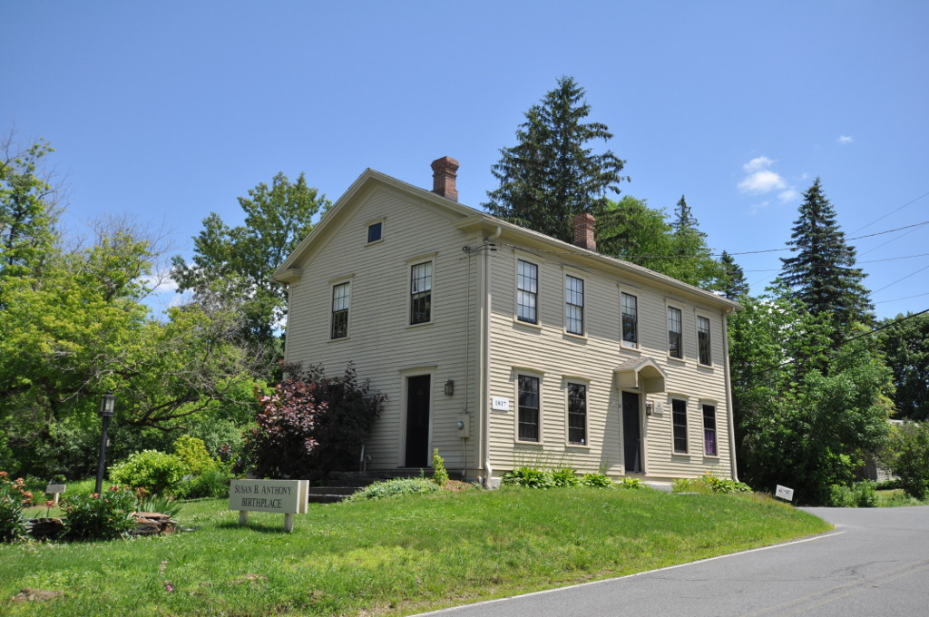
Anthony House
Museum · National Register of Historic Places · 4.2 mi
House in Adams, Massachusetts

Armory Block
Monument and historic site · National Register of Historic Places · 3.7 mi
United States historic place

Armstrong House
Monument and historic site · National Register of Historic Places · 2.2 mi
Historic house in Massachusetts, United States

Beaver Mill
Monument and historic site · National Register of Historic Places · 2.2 mi
Mill in North Adams, Massachusetts

Berkshire Mill No. 1
Monument and historic site · National Register of Historic Places · 3.5 mi
Factory in Adams, Massachusetts, United States

Blackinton Historic District
Monument and historic site · National Register of Historic Places · 1.3 mi
Historic district in North Adams, Massachusetts

Boston Finishing Works
Monument and historic site · National Register of Historic Places · 4.7 mi
Building in Massachusetts, United States


Charles Browne House
Monument and historic site · National Register of Historic Places · 1.1 mi
Historic house in Massachusetts, United States
50 more on the map.
Parks, trails and playgrounds33


Boston Aquarial and Zoological Gardens
Park · 5.6 mi
Public exhibit in Boston, Massachusetts

Forest Park Country Club
Golf course · 3.9 mi
Forest Park Avenue, Adams

Peter W. Foote Vietnam Veterans Memorial Skating Rink
Sports field and stadium · 1.1 mi
1267 Church Street, North Adams
21 more on the map.
Restaurants and cafes39

Trail House Kitchen & Bar
Restaurant · American, Grill, Italian · 3.0 mi
896 State Road
Fr-Sa 11:00-21:00; Su-Th 11:00-20:00

Korean Garden
Restaurant · Asian, Japanese, Korean, Sushi · 3.9 mi
240 Main St, Williamstown, MA 01267
Tu-Fr 11:00-21:00; Sa-Su 11:00-21:30



Angelina's Subs
Restaurant · Sandwich · 1.5 mi
152 American Legion Drive
Angelina's Subs
Restaurant · Sandwich · 3.3 mi
34 Columbia Street
27 more on the map.
Where to stay9
Churches and places of worship17
Quaker Meeting House
Place of worship · National Register of Historic Places · 3.4 mi
74 Valley Street
Saint Stanislaus Kostka Roman Catholic Church
Church · Catholic · 3.5 mi
25 Hoosac Street
Saint Thomas Aquinas Roman Catholic Church
Church · Catholic · 3.5 mi
2 Columbia Street
St. Elizabeth of Hungary Church
Church · Roman Catholic · 1.8 mi
68 Marshall Street
Shopping9
Gas and EV charging8
Schools, colleges and libraries30
Healthcare5
Map of North Adams
234 places. The map loads OpenStreetMap tiles when you open it.
Climate by month
Monthly table
| Month | High | Low | Rain |
|---|---|---|---|
| Jan | 32°F | 14°F | 2.5 in |
| Feb | 35°F | 16°F | 2.0 in |
| Mar | 44°F | 24°F | 3.1 in |
| Apr | 57°F | 34°F | 3.1 in |
| May | 69°F | 44°F | 3.7 in |
| Jun | 76°F | 53°F | 4.4 in |
| Jul | 81°F | 58°F | 4.1 in |
| Aug | 79°F | 56°F | 4.5 in |
| Sep | 72°F | 49°F | 4.2 in |
| Oct | 60°F | 38°F | 4.3 in |
| Nov | 48°F | 30°F | 3.2 in |
| Dec | 38°F | 22°F | 3.1 in |
U.S. Climate Normals 1991-2020 for North Adams Harriman Ap (3 mi away), NOAA NCEI.
People and cost of living
American Community Survey 5-year estimates, 2020-2024, U.S. Census Bureau. Estimates have margins of error, larger for small towns.
Disaster history
Berkshire County has had 19 federal disaster declarations since 2000, most often for severe storms.
- 2023-09-15: Hurricane Lee (Hurricane)
- 2020-03-27: Covid-19 Pandemic (Biological)
- 2020-03-13: Covid-19 (Biological)
- 2013-04-19: Severe Winter Storm, Snowstorm, And Flooding (Severe Storm)
- 2012-10-28: Hurricane Sandy (Hurricane)
- 2012-01-06: Severe Storm And Snowstorm (Severe Storm)
OpenFEMA disaster declarations summaries.
Getting there and nearby towns
Pittsfield Municipal Airport (PSF) is the nearest airport with scheduled flights listed in OpenStreetMap, 19 miles away.
- Baby Dragon map
- Adams 3 mi south, about 5 min by car
- Greenfield 27 mi east, about 43 min by car
- Albany 35 mi west, about 56 min by car
- Easthampton 36 mi southeast, about 59 min by car
- Amherst Town 38 mi southeast, about 1 h by car
- Holyoke 40 mi southeast, about 1 h by car
- Chicopee 44 mi southeast, about 1 h 15 min by car
- Agawam Town 48 mi southeast, about 1 h 15 min by car
- Springfield 49 mi southeast, about 1 h 15 min by car
- Longmeadow 52 mi southeast, about 1 h 30 min by car
Drive times are estimates from straight-line distance, not routes.
Local news
Headlines from INDB, the NEMICO news database.
Reviews, tips and questions
Loading what members have shared...
Sources and licences
- NCES EDGE (Public domain): public schools
- NOAA NCEI U.S. Climate Normals 1991-2020 (Public domain): climate by month
- OpenFEMA (Public domain): disaster declarations
- OpenStreetMap contributors (ODbL 1.0): places, airports, map data
- U.S. Census Bureau (Public domain): population, income, housing, education, commute
- Wikidata (CC0 1.0): elevation, founding date, time zone, website, landmarks and historic places
- Wikimedia Commons (see each image): photos
- Wikipedia (CC BY-SA 4.0): overview and history text
Photo credits
- Main Street North Adams, Beyond My Ken, CC BY-SA 4.0
- Quaker Meetinghouse, Adams MA, John Phelan, CC BY-SA 3.0
- Hillside Cemetery North Adams 1, Beyond My Ken, CC BY-SA 4.0
- MassMoCa, N-Lange.de, CC BY-SA 3.0
- WareMA ChurchStreetHD 03, User:Magicpiano, CC BY-SA 4.0
- Blackinton Company, North Adams MA, John Phelan, CC BY 3.0
- Windsor Print Works North Adams, Beyond My Ken, CC BY-SA 4.0
- US Post Office, Williamstown MA, John Phelan, CC BY 3.0
- The Boardman North Adams 2, Beyond My Ken, CC BY-SA 4.0
- Adams Railway Station, Ymblanter, CC BY-SA 3.0
- Williamstown station postcard, Unknown author Unknown author, Public domain
- Severance Block, Williamstown MA, John Phelan, CC BY 3.0
- AdamsMA SBAnthonyBirthplace, User:Magicpiano, CC BY-SA 4.0
- St. Joseph's School North Adams, Beyond My Ken, CC BY-SA 4.0
- Charles Browne House 932 South Church Street North Adams, Beyond My Ken, CC BY-SA 4.0
- Adams Park Street Firehouse, Ymblanter, CC BY-SA 3.0
- Maple Street Cemetery, Adams MA, John Phelan, CC BY-SA 3.0
- Armstrong House, North Adams MA, John Phelan, CC BY 3.0
- North Adams, MA - Inn on East Main Street 01 (9375725626), Joe Mabel from Seattle, US, CC BY-SA 2.0
- Sykes House, North Adams MA, John Phelan, CC BY 3.0
- Eber Sherman Farm, North Adams MA, John Phelan, CC BY 3.0
- Beaver Mill, North Adams MA, John Phelan, CC BY 3.0
- Hathaway Tenement, North Adams MA, John Phelan, CC BY 3.0
- AdamsMA FormerPhillipsWoolenMill, User:Magicpiano, CC BY-SA 4.0
- Crowley House 365 West Main North Adams, Beyond My Ken, CC BY-SA 4.0
- Adams, Massachusetts - 8297307158, Dougtone, CC BY-SA 2.0
- Bracewell Avenue, North Adams MA, John Phelan, CC BY 3.0
- 30Summer Street Adams, Ymblanter, CC BY-SA 3.0
- Armory Block, Adams MA, John Phelan, CC BY-SA 3.0
- Wells House, North Adams MA, John Phelan, CC BY 3.0
- Sherman Burbank Memorial Chapel, Williamstown MA, John Phelan, CC BY 3.0
- Hoosac Tunnel east portal, April 2013, Doug Kerr from Albany, NY, United States, CC BY-SA 2.0
- Norad Mill 60 Roberts Drive North Adams from west, Beyond My Ken, CC BY-SA 4.0
- WilliamstownMA BostonFinishingWorks1, Magicpiano, CC BY-SA 4.0
- William B. Sherman Farm, North Adams MA, John Phelan, CC BY 3.0
- P. J. Barrett Block, Adams MA, John Phelan, CC BY-SA 3.0
- NorthAdamsMA MCLA MurdockHall SmithHouse, Magicpiano, CC BY-SA 3.0
- Hoosac Street School, Adams MA, John Phelan, CC BY-SA 3.0
- 86 Park Street, Adams MA, John Phelan, CC BY-SA 3.0
- Mausert Block, Adams MA, John Phelan, CC BY-SA 3.0


Page built October 30, 2026. Spotted a mistake? Tell us or suggest a place.