


Meriden, Connecticut
Meriden is a city of 60,545 people in Connecticut, founded in 1867.
Why visit Meriden
Townapedia lists 50 museums and landmarks, 53 parks and trails, 129 places to eat, 21 places to stay and 23 attractions in and around town.
Highlights include Powder Ridge Ski Area, Wadsworth Falls State Park, Highland Historic District and Red Bridge.
July is the warmest month, with average highs of 84°F; January lows average 19°F.
Weather in Meriden
Forecast from the National Weather Service. Full forecast
About Meriden
Meriden is a city in New Haven County, Connecticut, United States, located halfway between the regional cities of New Haven and Hartford. The city is part of the South Central Connecticut Planning Region. In 2020, the population of the city was 60,850.
From the Wikipedia article Meriden, Connecticut (this version), under CC BY-SA 4.0.
Things to do23


Wadsworth Falls State Park
Waterfall · 5.7 mi
State park in Connecticut, United States

Holiday Cinemas Stadium 14
Cinema and theater · 3.5 mi
970 North Colony Road, Wallingford

11 more on the map.
Museums and landmarks50

Highland Historic District
Monument and historic site · National Register of Historic Places · 3.6 mi
Human settlement in Connecticut, United States of America

Red Bridge
Bridge · National Register of Historic Places · 2.5 mi
Bridge in Meriden, Connecticut, United States

Avery Clark House
Monument and historic site · National Register of Historic Places · 3.6 mi
House in Southington, Connecticut

Capt. Samuel Woodruff House
Monument and historic site · National Register of Historic Places · 5.0 mi
House in Southington, Connecticut
Center Street Cemetery
Monument and historic site · National Register of Historic Places · 5.8 mi
Cemetery in Wallingford, Connecticut
Charter Oak Firehouse
Monument and historic site · National Register of Historic Places · 0.6 mi
Fire station in Meriden, United States of America
Clark Brothers Factory No. 2
Monument and historic site · National Register of Historic Places · 5.8 mi
Historic building in Southington, Connecticut, United States
Colony Street-West Main Street Historic District
Monument and historic site · National Register of Historic Places · 0.5 mi
Historic district in Connecticut, United States
Curtis Memorial Library
Monument and historic site · National Register of Historic Places
Historic building in Meriden, Connecticut, United States
David Lyman II House
Monument and historic site · National Register of Historic Places · 5.1 mi
Middlefield, Connecticut, listed on the NRHP in Middlesex County
Dr. Henry Skelton House
Monument and historic site · National Register of Historic Places · 6.0 mi
House in Southington, Connecticut
Dr. J. Porter House
Monument and historic site · National Register of Historic Places · 5.1 mi
In Southington CT, listed on the NRHP in Connecticut
38 more on the map.
Parks, trails and playgrounds53
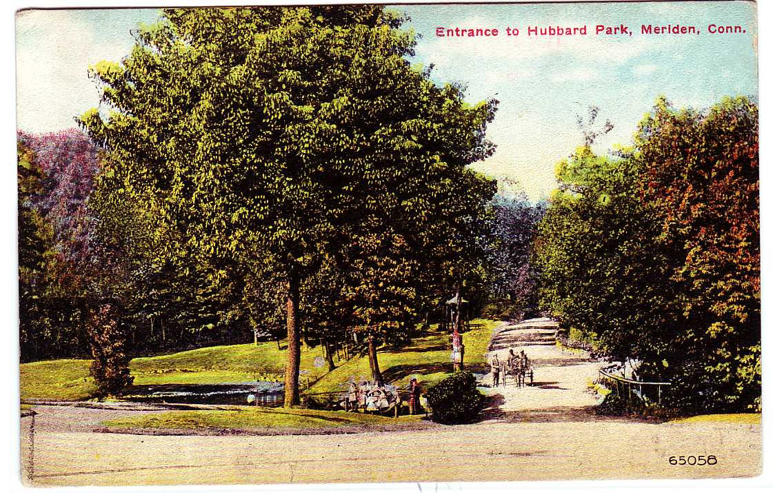


Hubbard Park
Park · National Register of Historic Places · 2.7 mi
Which extends into adjacent town Southington, and is listed on the NRHP in Connecticut

North End Field
Park · 1.0 mi
Municipal, Open To Public Without Fee
234 Britannia Street, Meriden
Smith Park
Park · 4.6 mi
Park in Connecticut, United States of America, United States of America


41 more on the map.
Restaurants and cafes129

Ted's Restaurant Steamed Cheeseburgers
Restaurant · Burger · 0.9 mi
1046 Broad Street, Meriden
Mo-We 11:00-21:00; Th-Sa 11:00-22:00; Su 11:00-21:00

Back 9 Social
Bar and pub · 4.2 mi
This place features golf simulation
805 North Colony Road, Wallingford
Mo-Tu off; We-Th 16:00-22:00; Fr-Sa 10:00-23:00; Su 10:00-18:00
Silver Sands Pizza
Restaurant · Pizza · 3.3 mi
994 N Colony Rd
Mo-Th 10:00-21:00; Fr, Sa 10:00-10:00; Su 11:00-21:00
Hubbard Park Pizza
Restaurant · Pizza · 3.3 mi
Restaurant - Pizza Place
262 Meriden-Waterbury Turnpike, Southington

The Wine Cellar Outlet Wallingford
Brewery and winery · 4.1 mi
42 Capital Dr, Wallingford
Mo-We 11:00-18:00; Th-Fr 10:00-19:00; Sa 10:00-18:00; Su 11:00-18:00
Pho Ethan
Restaurant · Vietnamese · 2.6 mi
North Colony Road
Su-Th 10:00-22:00; Fr-Sa 10:00-23:00

Blackbird Tavern
Bar and pub · 4.0 mi
6 Way Road, Middlefield
Tu 16:00-24:00; We-Sa 00:00-12:00,16:00-24:00; Su 00:00-12:00,15:00-21:00
117 more on the map.
Where to stay21
Four Points by Sheraton Meriden
Motel and hotel · 2.0 mi
275 Research Parkway, Meriden
Hawthorn Suites by Wyndham Hartford Meriden
Motel and hotel · 1.7 mi
1149 East Main Street, Meriden
Churches and places of worship40
First Congregational Church of Meriden
Church · United Church Of Christ · 0.4 mi
62 Colony Street, Meriden
Iglesia Cristiana Alpha y Omega Asambleas de Dios
Church · Assemblies Of God · 0.8 mi
134 Springdale Avenue, Meriden
Shopping34
Gas and EV charging23
Schools, colleges and libraries52
Healthcare11
Hartford HealthCare-GoHealth Urgent Care
Clinic and pharmacy · 2.0 mi
482 South Broad Street, Meriden
Department of Developmental Services Meriden Center
Clinic and pharmacy · 1.6 mi
Map of Meriden
250 places. The map loads OpenStreetMap tiles when you open it.
Climate by month
Monthly table
| Month | High | Low | Rain |
|---|---|---|---|
| Jan | 37°F | 19°F | 3.0 in |
| Feb | 39°F | 20°F | 2.9 in |
| Mar | 48°F | 28°F | 4.0 in |
| Apr | 60°F | 38°F | 4.1 in |
| May | 70°F | 48°F | 3.5 in |
| Jun | 79°F | 57°F | 4.0 in |
| Jul | 84°F | 62°F | 3.4 in |
| Aug | 82°F | 61°F | 3.5 in |
| Sep | 75°F | 54°F | 4.3 in |
| Oct | 64°F | 42°F | 4.5 in |
| Nov | 52°F | 32°F | 3.4 in |
| Dec | 42°F | 24°F | 4.1 in |
U.S. Climate Normals 1991-2020 for Meriden Markham Muni Ap (3 mi away), NOAA NCEI.
People and cost of living
American Community Survey 5-year estimates, 2020-2024, U.S. Census Bureau. Estimates have margins of error, larger for small towns.
Disaster history
The county has had 27 federal disaster declarations since 2000, most often for severe storms.
- 2024-10-24: Hawthorne Fire (Fire)
- 2024-09-20: Severe Storm, Flooding, Landslides, And Mudslides (Severe Storm)
- 2024-08-21: Severe Storms, Flooding, Landslides, And Mudslides (Severe Storm)
- 2021-10-30: Remnants Of Hurricane Ida (Hurricane)
- 2021-08-22: Hurricane Henri (Hurricane)
- 2021-01-12: Tropical Storm Isaias (Hurricane)
OpenFEMA disaster declarations summaries.
Getting there and nearby towns
Hartford–Brainard Airport (HFD) is the nearest airport with scheduled flights listed in OpenStreetMap, 16 miles away.
- Wallingford Center 6 mi south, about 10 min by car
- Middletown 7 mi east, about 12 min by car
- New Britain 10 mi north, about 16 min by car
- Newington 11 mi north, about 18 min by car
- North Haven 11 mi south, about 18 min by car
- Waterbury 13 mi west, about 20 min by car
- Bristol 13 mi northwest, about 20 min by car
- Wethersfield 13 mi northeast, about 21 min by car
- Naugatuck 14 mi west, about 22 min by car
- West Hartford 16 mi north, about 26 min by car
Drive times are estimates from straight-line distance, not routes.
Local news
Headlines from INDB, the NEMICO news database.
Reviews, tips and questions
Loading what members have shared...
Sources and licences
- NCES EDGE (Public domain): public schools
- NOAA NCEI U.S. Climate Normals 1991-2020 (Public domain): climate by month
- OpenFEMA (Public domain): disaster declarations
- OpenStreetMap contributors (ODbL 1.0): places, airports, map data
- U.S. Census Bureau (Public domain): population, income, housing, education, commute
- Wikidata (CC0 1.0): elevation, founding date, time zone, website, landmarks and historic places
- Wikimedia Commons (see each image): photos
- Wikipedia (CC BY-SA 4.0): overview and history text
Photo credits
- Augusta Curtis Cultural Center, Meriden, Connecticut, Kenneth C. Zirkel, CC BY-SA 4.0
- Masjid al Rawdah mosque, Meriden, Connecticut, Kenneth C. Zirkel, CC BY-SA 4.0
- Christopher Columbus memorial in Meriden, Connecticut, Kenneth C. Zirkel, CC BY-SA 4.0
- Saint Paul's Universalist Church, Meriden, Connecticut, Kenneth C. Zirkel, CC BY-SA 4.0
- First United Methodist Church, Meriden, Connecticut, Kenneth C. Zirkel, CC BY-SA 4.0
- Old Meriden High School, corner view, Kenneth C. Zirkel, CC BY-SA 4.0
- Soldiers Monument in Meriden, Connecticut, Kenneth C. Zirkel, CC BY-SA 4.0
- Old Meriden High School, Connecticut, Kenneth C. Zirkel, CC BY-SA 4.0
- The Walking Bridge At The Hub Park In Meriden, Mark Balcher, CC BY 3.0
- J.J. Ferry & Sons Funeral Home in Meriden, Connecticut, Kenneth C. Zirkel, CC BY-SA 4.0
- (241 365) Tower One Meriden CT 2015 (17086027265), Marcus Balcher from Sharon, CT, United States, CC BY-SA 2.0
- Moon Over Western Skies Meriden, CT Storm Anna (24330213680), Marcus Balcher from Daytona, FL, United States, CC BY-SA 2.0
- Victoria Towers Meriden In January, Mark Balcher, CC BY 3.0
- CT Transit route C5 bus at Meriden station, December 2016, Pi.1415926535, CC BY-SA 3.0
- Meriden station panorama, December 2015, Pi.1415926535, CC BY-SA 3.0
- (361 365) The Meriden Green. Meriden, CT State Street Side. (29442548550), Marcus Balcher from Sharon, CT, United States, CC BY-SA 2.0
- The Hub In Downtown Meriden Ct, Mark Balcher, CC BY 3.0
- New pedestrian bridge at Meriden station under construction, December 2016, Pi.1415926535, CC BY-SA 3.0
- Temporary platform at Meriden station, December 2016, Pi.1415926535, CC BY-SA 3.0
- New platforms at Meriden station under construction, December 2016, Pi.1415926535, CC BY-SA 3.0
- Northbound platform at Meriden station, December 2017, Pi.1415926535, CC BY-SA 3.0
- Meriden station from platform, December 2015, Pi.1415926535, CC BY-SA 3.0
- New parking lot and bus stops at Meriden station, December 2017, Pi.1415926535, CC BY-SA 3.0
- North ends of platforms at Meriden station, December 2017, Pi.1415926535, CC BY-SA 3.0
- CT Transit bus at Meriden station, December 2017, Pi.1415926535, CC BY-SA 3.0
- Pedestrian overpass at Meriden station, December 2017, Pi.1415926535, CC BY-SA 3.0
- Curved platforms at Meriden station, December 2017, Pi.1415926535, CC BY-SA 3.0
- Former platform edge at Meriden station, December 2017, Pi.1415926535, CC BY-SA 3.0
- Meriden station platforms and overpass, December 2017, Pi.1415926535, CC BY-SA 3.0
- Miller Memorial Barn on Olive St. Meriden, CT - Flickr - Pentax K-x Connecticut Man, Marcus Balcher from Daytona, FL, United States, CC BY-SA 2.0
- Meriden station postcard, Unknown author Unknown author, Public domain
- MeridenCT MeridenCurtainFixtureCompanyFactory, Magicpiano, CC BY-SA 4.0
- PostcardMeridenCTWestMainStreetBirdsEyeView1912, Unknown author Unknown author, Public domain
- East Main Street with streetcars, Meriden - postcard, Unknown author Unknown author, Public domain
- PostcardHubbardParkEntranceMeridenCT1913, Unknown author Unknown author, Public domain
- Red Bridge 2012-09-20 22-07-04, danard99, CC BY-SA 3.0
- HIGHLAND HISTORIC DISTRICT, MIDDLETOWN, MIDDLESEX COUNTY, CT, JERRYE & ROY KLOTZ.M.D., CC BY-SA 4.0
- Wallingford Amtrak station, November 2013, Adam Moss from Highland Park, NJ, United States, CC BY-SA 2.0
- SouthingtonCT CaptSamuelWoodruffHouse, Magicpiano, CC BY-SA 4.0
- MiddlefieldCT WIlliamWardJrHouse, Magicpiano, CC BY-SA 3.0


Page built October 30, 2026. Spotted a mistake? Tell us or suggest a place.