
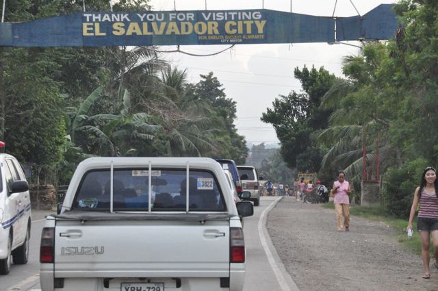


El Salvador, Philippines
El Salvador is a town of 6,904 people in Northern Mindanao, Philippines, founded in June 15, 1948.
Why visit El Salvador
Townapedia lists 1 park or trail, 14 places to eat, 3 places to stay and 3 attractions in and around town.
Weather in El Salvador
Forecast from MET Norway (CC BY 4.0). Full forecast
About El Salvador
El Salvador, officially the City of El Salvador (Cebuano: Dakbayan sa El Salvador; Filipino: Lungsod ng El Salvador), is a component city in the province of Misamis Oriental, Philippines. According to the 2024 census, it has a population of 62,126 people.
From the Wikipedia article El Salvador, Misamis Oriental (this version), under CC BY-SA 4.0.
Things to do3


Parks, trails and playgrounds1

Restaurants and cafes14


ABL Resturant
Restaurant · Barbecue, Regional · 5.4 km
Butuan-Cagayan de Oro-Iligan Road, Alubijid




2 more on the map.
Where to stay3

History
During Spanish colonial era, a soldier named Alejandro Acusar sailed with his family from Bohol to the area what is now El Salvador to seek a new life. From a distance while sailing, they sighted a place and decided to dock. They found a place to have abundant nipa huts, in which they named it Taganipa, Tagnipa or Taguipa. Acusar and his small family had then established themselves through farming and fishing. A wave of migrants from Bohol later followed as well as settlers from Luzon, other parts of Visayas and neighboring areas surrounding Taganipa settled in the area following years later, establishing themselves as farmers and fisherfolks.
El Salvador was created from the barrios of El Salvador and Molugan with their sitios known as Sala, Sambulawan, Sinaloc, Lagtang, Talaba, Kalabaylabay and Hinigdaan, formerly part of Cagayan de Misamis, Misamis Oriental, in 1948.
From the History section of El Salvador, Misamis Oriental on Wikipedia, under CC BY-SA 4.0.
Churches and places of worship6
Iglesia ni Cristo
Church · Iglesia Ni Cristo · 1.8 km
Butuan-Cagayan de Oro-Iligan Road
Shopping3
Gas and EV charging16
Schools, colleges and libraries41
Alubijid National Comprehensive High School
School · 5.3 km
Bonifacio Street, Alubijid
Bukidnon State University - Alubijid Campus
School · 5.5 km
Santa Cruz Street, Alubijid
Healthcare5
El Salvador City Health Center
Clinic and pharmacy · 0.7 km
Feliciano O. Ayudtud Street
OWWA Misamis Oriental Provincial Hospital
Hospital · 6.1 km
National Highway, Alubijid
Map of El Salvador
92 places. The map loads OpenStreetMap tiles when you open it.
Getting there and nearby towns
Laguindingan Airport (CGY) is the nearest airport with scheduled flights listed in OpenStreetMap, 9 km away.
- Opol 7 km southeast, about 7 min by car
- Cagayan de Oro 16 km southeast, about 16 min by car
- Tagoloan 26 km east, about 26 min by car
- Initao 25 km west, about 25 min by car
- Villanueva 28 km east, about 28 min by car
- Naawan 29 km southwest, about 29 min by car
- Libona 34 km southeast, about 34 min by car
- Iligan City 37 km south, about 37 min by car
- Manolo Fortich 43 km southeast, about 43 min by car
- Iligan 48 km southwest, about 48 min by car
Drive times are estimates from straight-line distance, not routes.
Local news
Headlines from INDB.
Reviews, tips and questions
Loading what members have shared...
Sources and licences
- GeoNames (CC BY 4.0): population, coordinates, regions and time zone
- Mapillary (see each image): photos
- OpenStreetMap contributors (ODbL 1.0): places, airports, map data
- Wikidata (CC0 1.0): elevation, founding date, time zone, website
- Wikimedia Commons (see each image): photos
- Wikipedia (CC BY-SA 4.0): overview and history text
Photo credits
- El Salvador City Marker, Marienicolelim, CC BY-SA 3.0
- Divine Mercy Shrine, Sepherine13100, CC0
- Barangay Health Station of Baybay, Alubijid, Ahri.boy, CC BY 4.0
- Barangay Hall of Baybay, Alubijid, Ahri.boy, CC BY 4.0
- Isolation building of Baybay, Alubijid, Ahri.boy, CC BY 4.0
- Alubijid National Comprehensive High School, Ahri.boy, CC BY 4.0
- Alubijid National Comprehensive High School 2, Ahri.boy, CC BY 4.0
- Alubijid Public Market ruins 02, Ahri Boy, CC BY 4.0
- Alubijid Public Market ruins 01, Ahri Boy, CC BY 4.0
- Alubijid National Comprehensive High School Covered Court, Ahri Boy, CC BY 4.0
- Patintero in Alubijid, Ahri Boy, CC BY 4.0
- Dancesport at Alubijid National Comprehensive High School 3, Ahri Boy, CC BY 4.0
- Dancesport at Alubijid National Comprehensive High School 5, Ahri Boy, CC BY 4.0
- Buwan ng Wika at the Alubijid National Comprehensive High School Covered Court, Ahri Boy, CC BY 4.0
- Dancesport at Alubijid National Comprehensive High School 4, Ahri Boy, CC BY 4.0
- Dancesport at Alubijid National Comprehensive High School 6, Ahri Boy, CC BY 4.0
- Buwan ng Wika at the Alubijid National Comprehensive High School Covered Court 2, Ahri Boy, CC BY 4.0
- Dancesport at Alubijid National Comprehensive High School 2, Ahri Boy, CC BY 4.0
- Dancesport at Alubijid National Comprehensive High School, Ahri Boy, CC BY 4.0
- Piaggio Ape City, Ahri.boy, CC BY 4.0
- Interior of a Piaggio Ape City, Ahri.boy, CC BY 4.0
- Toyota Raize 2021 Red, Ahri.boy, CC BY 4.0
- B&G Merlot back, Ahri.boy, CC BY 4.0
- B&G Merlot, Ahri.boy, CC BY 4.0
- Barangay Hall of Poblacion, Alubijid, Ahri.boy, CC BY 4.0
- Bukidnon State University Alubijid Campus, Ahri.boy, CC BY 4.0
- Minute Burger Double Cheesy Burger, Ahri Boy, CC BY 4.0
- DJ setup at the Bukidnon State University Alubijid Campus, Ahri.boy, CC BY 4.0
- Booths at the Bukidnon State University Alubijid Campus, Ahri.boy, CC BY 4.0
- RUSI Caruza 200i, Ahri Boy, CC BY 4.0
- Iced coffee (with special milk), Ahri.boy, CC BY 4.0
- Basketball at the Alubijid Municipal Covered Court, Ahri.boy, CC BY 4.0
- Bukidnon State University Alubijid Campus 2, Ahri.boy, CC BY 4.0
- Booths at the Alubijid Municipal Covered Court, Ahri.boy, CC BY 4.0
- Alubijid Municipal Covered Court at night 7, Ahri Boy, CC BY 4.0
- RUSI Caruza 200i 2, Ahri Boy, CC BY 4.0
- Alubijid Municipal Covered Court 2, Ahri.boy, CC BY 4.0
- Alubijid Municipal Covered Court, Ahri.boy, CC BY 4.0
- Alubijid Municipal Covered Court at night 5, Ahri.boy, CC BY 4.0
- Alubijid Municipal Covered Court at night 4, Ahri.boy, CC BY 4.0
- Street-level photo, dp24ph, CC BY-SA 4.0
- Street-level photo, dp24ph, CC BY-SA 4.0
- Street-level photo, dp24ph, CC BY-SA 4.0


Page built November 7, 2026. Spotted a mistake? Tell us or suggest a place.