


Pines Lake, New Jersey
Pines Lake is a community of 2,882 people in Passaic County, New Jersey.
Why visit Pines Lake
Townapedia lists 43 museums and landmarks, 30 parks and trails, 37 places to eat and 3 attractions in and around town.
Highlights include Packanack Mountain, Ackerman-Boyd House, Demarest House and Pompton Aquatic Park.
July is the warmest month, with average highs of 84°F; January lows average 20°F.
Weather in Pines Lake
Forecast from the National Weather Service. Full forecast
About Pines Lake
Pines Lake is an unincorporated community and census-designated place (CDP) located on a lake in Wayne, in Passaic County, in the U.S. state of New Jersey. As of the 2020 census, Pines Lake had a population of 3,033. Pines Lake was started in the 1920s as a vacation community around a man-made lake approximately 1.5 miles (2.4 km) long and 0.5 miles (0.80 km) wide. Many of the original homes were modified log cabins.
From the Wikipedia article Pines Lake, New Jersey (this version), under CC BY-SA 4.0.
Things to do3


StageWorks at Studio 237
Cinema and theater · Catholic · 1.2 mi
237 Paterson-Hamburg Turnpike, Pompton Lakes
Museums and landmarks43

Ackerman-Boyd House
Monument and historic site · National Register of Historic Places · 1.4 mi
United States historic place

Demarest House
Monument and historic site · National Register of Historic Places · 1.5 mi
Historic house in Oakland, New Jersey, USA

Demarest-Hopper House
Monument and historic site · National Register of Historic Places · 0.9 mi
Historic house in Bergen County, New Jersey

Jacobus Demarest House
Monument and historic site · National Register of Historic Places · 1.6 mi
Historic house in Oakland, New Jersey

Martin Berry House
Monument and historic site · National Register of Historic Places · 2.4 mi
Historic house in Morris County, New Jersey

Mead-Van Duyne House
Monument and historic site · National Register of Historic Places · 1.8 mi
Historic house in Passaic County, New Jersey

Pompton Plains
Monument and historic site · National Register of Historic Places · 2.5 mi
Railway station in Pequannock Township, the United States of America
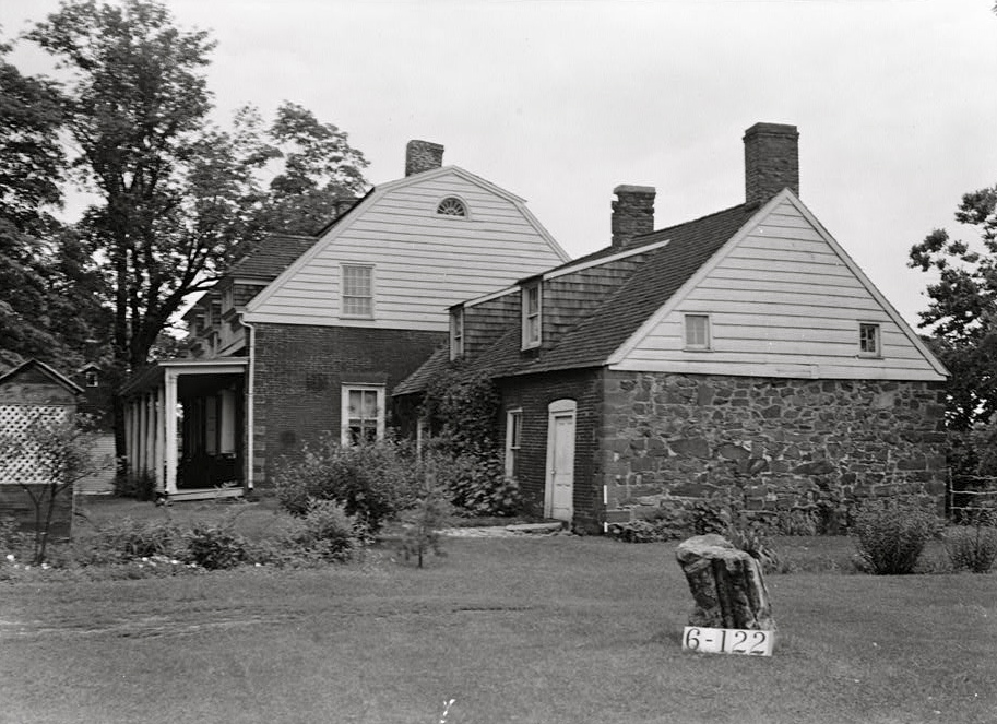
Schuyler-Colfax House
Monument and historic site · National Register of Historic Places · 1.1 mi
Historic house in New Jersey, United States

Storms House
Monument and historic site · National Register of Historic Places · 1.5 mi
Historic house in Franklin Lakes, New Jersey

Van Allen House
Monument and historic site · National Register of Historic Places · 2.6 mi
Historic house in New Jersey, United States

Van Blarcom House
Monument and historic site · National Register of Historic Places · 2.6 mi
Historic house in New Jersey, United States


Van Houten-Ackerman House
Monument and historic site · National Register of Historic Places · 1.1 mi
United States historic house in New Jersey
31 more on the map.
Parks, trails and playgrounds30

Pompton Aquatic Park
Park · 1.7 mi
Park in New Jersey, United States of America


18 more on the map.
Restaurants and cafes37


Jardín Latino
Restaurant · Latin American · 1.5 mi
118 Wanaque Avenue, Pompton Lakes

Mack's American Bar & Grill
Diner · American · 1.5 mi
300 Wanaque Avenue, Pompton Lakes
Monica's Restaurant
Restaurant · Italian · 1.5 mi
1 Lakeside Avenue, Pompton Lakes
Mr. Ramen + Miss Korea
Restaurant · Asian · 1.5 mi
1 Cannonball Road, Pompton Lakes
Nicky G's Pizzeria & Restaurant
Restaurant · Pizza · 1.5 mi
4 Colfax Avenue, Pompton Lakes
25 more on the map.
Churches and places of worship8
Christ Episcopal Church
Church · Episcopal · 1.2 mi
400 Ramapo Avenue, Pompton Lakes
St Mary's Roman Catholic Church
Church · Catholic · 1.4 mi
17 Pompton Avenue, Pompton Lakes
St. Michael's Russian Orthodox Church
Church · Russian Orthodox · 1.5 mi
171 Colfax Road, Wayne
Al-Mustafa Islamic Center
Place of worship · 1.3 mi
21 Passaic Avenue, Pompton Lakes
Shopping15
Home Field Advantage Sporting Goods
Shop · 1.5 mi
219 Wanaque Avenue, Pompton Lakes
Jersey Pride Deli & Catering
Shop · 1.0 mi
715 Paterson-Hamburg Turnpike, Pompton Lakes
Gas and EV charging4
Schools, colleges and libraries49
Franklin Avenue Middle School
School · 3.5 mi
755 Franklin Avenue, Franklin Lakes
Healthcare8
Orthopedic Surgery-Sports Center
Clinic and pharmacy · 1.5 mi
2035 Paterson-Hamburg Turnpike, Wayne
Riverview Pharmacy
Clinic and pharmacy · 1.1 mi
2405 Paterson-Hamburg Turnpike, Wayne
Shoppers Pharmacy
Clinic and pharmacy · 1.0 mi
750 Paterson-Hamburg Turnpike, Pompton Lakes
TruYou Dental Wayne
Clinic and pharmacy · 1.5 mi
2035 Paterson-Hamburg Turnpike, Wayne
ValuRx Pharmacy
Clinic and pharmacy · 1.4 mi
2075 Paterson-Hamburg Turnpike, Wayne
Map of Pines Lake
197 places. The map loads OpenStreetMap tiles when you open it.
Climate by month
Monthly table
| Month | High | Low | Rain |
|---|---|---|---|
| Jan | 38°F | 20°F | 3.4 in |
| Feb | 40°F | 20°F | 2.7 in |
| Mar | 48°F | 29°F | 3.9 in |
| Apr | 60°F | 39°F | 4.2 in |
| May | 71°F | 50°F | 3.6 in |
| Jun | 79°F | 58°F | 5.1 in |
| Jul | 84°F | 64°F | 4.7 in |
| Aug | 83°F | 63°F | 4.6 in |
| Sep | 76°F | 56°F | 4.0 in |
| Oct | 64°F | 43°F | 4.4 in |
| Nov | 53°F | 35°F | 3.8 in |
| Dec | 43°F | 27°F | 4.0 in |
U.S. Climate Normals 1991-2020 for Wanaque Raymond Dam (4 mi away), NOAA NCEI.
People and cost of living
American Community Survey 5-year estimates, 2020-2024, U.S. Census Bureau. Estimates have margins of error, larger for small towns.
Disaster history
Passaic County has had 20 federal disaster declarations since 2000, most often for hurricanes.
- 2021-09-05: Remnants Of Hurricane Ida (Hurricane)
- 2021-09-02: Remnants Of Hurricane Ida (Hurricane)
- 2020-03-25: Covid-19 Pandemic (Biological)
- 2020-03-13: Covid-19 (Biological)
- 2018-06-08: Severe Winter Storm And Snowstorm (Severe Storm)
- 2012-10-30: Hurricane Sandy (Hurricane)
OpenFEMA disaster declarations summaries.
Getting there and nearby towns
Essex County Airport (CDW) is the nearest airport with scheduled flights listed in OpenStreetMap, 9 miles away.
- Pompton Lakes 1 mi west, about 2 min by car
- Oakland 3 mi northeast, about 4 min by car
- Pompton Plains 3 mi southwest, about 5 min by car
- Franklin Lakes 3 mi east, about 5 min by car
- Wanaque 3 mi northwest, about 5 min by car
- Packanack Lake 4 mi south, about 7 min by car
- Butler 4 mi west, about 7 min by car
- Preakness 5 mi southeast, about 7 min by car
- Bloomingdale 5 mi northwest, about 7 min by car
- North Haledon 5 mi southeast, about 8 min by car
Drive times are estimates from straight-line distance, not routes.
Local news
Headlines from INDB, the NEMICO news database.
Reviews, tips and questions
Loading what members have shared...
Sources and licences
- NCES EDGE (Public domain): public schools
- NOAA NCEI U.S. Climate Normals 1991-2020 (Public domain): climate by month
- OpenFEMA (Public domain): disaster declarations
- OpenStreetMap contributors (ODbL 1.0): places, airports, map data
- U.S. Census Bureau (Public domain): population, income, housing, education, commute
- Wikidata (CC0 1.0): elevation, founding date, time zone, website, landmarks and historic places
- Wikimedia Commons (see each image): photos
- Wikipedia (CC BY-SA 4.0): overview and history text
Photo credits
- ACKERMAN-BOYD HOUSE, FRANKLIN LAKES, BERGEN COUNTY, NJ, JERRYE & ROY KLOTZ MD, CC BY-SA 4.0
- VAN BLARCOM HOUSE, FRANKLIN LAKES, BERGEN COUNTY, NJ, JERRYE & ROY KLOTZ MD, CC BY-SA 4.0
- MARTIN BERRY HOUSE, POMPTON PLAINS, MORRIS COUNTY, Jerrye & Roy Klotz, MD, CC BY-SA 3.0
- HENDRICK VAN ALLEN HOUSE, OAKLAND, BERGEN COUNTY, NJ, JERRYE & ROY KLOTZ M.D., CC BY-SA 4.0
- VanRiper-Hopper House, Lithium6ion, Public domain
- STORMS HOUSE, FRANKLIN LAKES, BERGEN COUNTY, NJ, JERRYE & ROY KLOTZ MD, CC BY-SA 4.0
- VAN WINKLE HOUSE, FRANKLIN LAKES, BERGEN COUNTY, NJ, JERRYE & ROY KLOTZ MD, CC BY-SA 4.0
- Schuyler-Colfax House, Nathaniel R. Ewan, Public domain
- Pompton Plains Station - September 2014, Adam Moss, CC BY-SA 2.0
- DEMAREST-HOPPER HOUSE, OAKLAND, BERGEN COUNTY, NJ, JERRYE & ROY KLOTZ M.D., CC BY-SA 4.0
- Demarest House, Oakland, Bergen County, NJ, JERRYE & ROY KLOTZ M.D., CC BY-SA 4.0
- JACOBUS S. DEMAREST HOUSE, OAKLAND, BERGEN COUNTY, NJ, JERRYE & ROY KLOTZ M.D., CC BY-SA 4.0
- VAN HOUTON-ACKERMAN HOUSE, FRANKLIN LAKES, BERGEN COUNTY, NJ, JERRYE & ROY KLOTZ MD, CC BY-SA 4.0
- VAN WINKLE-FOX HOUSE, OAKLAND, BERGEN COUNTY, NJ, JERRYE & ROY KLOTZ M.D., CC BY-SA 4.0
- REACTION MOTORS ROCKET TEST FACILITY, FRANKLIN LAKES, BERGEN COUNTY, NY, JERRYE & ROY KLOTZ MD, CC BY-SA 4.0
- 2018-07-25 10 32 39 View north along U.S. Route 202 (Terhune Drive) at Circle Avenue in Wayne Township, Passaic County, New Jersey, Famartin, CC BY-SA 4.0
- 2018-07-20 14 00 42 View east along Bergen County Route 502 (Breakneck Road) just west of Bergen County Route 93 (Long Hill Road) in Oakland, Bergen County, New Jersey, Famartin, CC BY-SA 4.0
- 2018-07-20 13 52 47 View west along Bergen County Route 502 (Breakneck Road) just west of Bergen County Route 93 (Long Hill Road) in Oakland, Bergen County, New Jersey, Famartin, CC BY-SA 4.0
- 2018-07-25 10 41 15 View south along U.S. Route 202 (Terhune Drive) at Passaic County Route 689 (Hamburg Turnpike) in Wayne Township, Passaic County, New Jersey, Famartin, CC BY-SA 4.0
- 2018-07-20 13 49 52 View east along Bergen County Route 502 (Long Hill Road) just east of Bauer Drive in Oakland, Bergen County, New Jersey, Famartin, CC BY-SA 4.0
- 2018-07-20 13 49 32 View west along Bergen County Route 502 (Long Hill Road) just east of Bauer Drive in Oakland, Bergen County, New Jersey, Famartin, CC BY-SA 4.0
- Schuyler-Colfax House 2024, RomeImagesPhoto, CC BY-SA 4.0
- WayneNJ SchuylerColfaxHouse, Magicpiano, CC BY-SA 4.0
- Snowed in with the mini. Yay for installed snow tires. (5295505052), William J Sisti from Morristown, NJ, USA, CC BY-SA 2.0
- Digging out the mini (5296798474), William J Sisti from Morristown, NJ, USA, CC BY-SA 2.0
- 2018-07-19 17 45 03 View south along U.S. Route 202 (Ramapo Valley Road) just south of Dotty Road in Oakland, Bergen County, New Jersey, Famartin, CC BY-SA 4.0
- 2018-07-19 17 49 44 View north along U.S. Route 202 (Ramapo Valley Road) just south of Plaza Road in Oakland, Bergen County, New Jersey, Famartin, CC BY-SA 4.0
- 2018-07-25 10 49 22 View south along U.S. Route 202 and east along Passaic County Route 689 (Hamburg Turnpike) just northwest of Black Oak Ridge Road in Wayne Township, Passaic County, New Jersey, Famartin, CC BY-SA 4.0
- 2018-07-25 10 26 42 View north along U.S. Route 202 and west along Passaic County Route 689 (Hamburg Turnpike) just northwest of Black Oak Ridge Road in Wayne Township, Passaic County, New Jersey, Famartin, CC BY-SA 4.0
- Pompton Lakes, NJ Municipal Building, Nov. 2025, Mr. Matté (if there is an issue with this image, contact me using this image's Commons talk page , my Commons user talk page , or my English Wikipedia user talk page ; I'll know about it a lot faster), CC BY-SA 4.0
- 2018-07-20 14 05 48 View west along Bergen County Route 502 (Franklin Lake Road) at Bergen County Route 117 (Colonial Road) in Franklin Lakes, Bergen County, New Jersey, Famartin, CC BY-SA 4.0
- WGHT-studio, Kether83, CC BY-SA 4.0


Page built October 30, 2026. Spotted a mistake? Tell us or suggest a place.